
Mori Atlas logo
Nature reserveNaturschutzgebiet Der Spieß – An der Spießbrücke

A preserved wetland mosaic and historic oxbow channel within the Upper Rhine lowland landscape

Naturschutzgebiet Der Spieß An der Spießbrücke Nature Reserve and Rhine Floodplain Geography

The Naturschutzgebiet Der Spieß An der Spießbrücke nature reserve encompasses a rare, silted Rhine oxbow near Worms, representing a vital segment of the Upper Rhine floodplain. This protected area features a mosaic of reedbeds, sedge stands, and wet meadows that serve as essential habitat for wetland birds. By maintaining a landscape character reflective of pre-drainage conditions, the site offers a unique window into the historical hydrology and ecological restoration efforts defining this part of Rhineland-Palatinate.

wetlandnature reserveNaturschutzgebietformer Rhine oxbowAltrheinreedbeds
A stylized vector illustration of a sunny nature scene featuring a winding river, trees, a small island with reeds, and cliffs with a waterfall in the background.

Naturschutzgebiet Der Spieß – An der Spießbrücke

Nature reserve

Park overview

Structured park overview, official facts, and landscape profile for Der Spieß, An der Spießbrücke Nature Reserve

Der Spieß, An der Spießbrücke Nature Reserve park facts, protected area profile, and essential visitor context

Review the core facts for Der Spieß, An der Spießbrücke Nature Reserve, including designation, size, terrain, visitor scale, habitats, and operating context in one park-focused overview.

About Der Spieß, An der Spießbrücke Nature Reserve

The Der Spieß – An der Spießbrücke Nature Reserve is a small but ecologically focused protected area in the northern outskirts of the city of Worms, in the state of Rhineland-Palatinate. Despite occupying only about 9 hectares, it carries meaningful conservation weight because it preserves a segment of an old Rhine arm that has evolved into a shallow wetland complex of exactly the type that once characterized much of the Upper Rhine lowlands. The roughly rectangular reserve sits north of the Worms district of Rheindürkheim and lies within the wider Rheinhessisches Rheingebiet landscape protection area, integrating a small wetland sanctuary into a much broader buffer of protected Rhine-side scenery.

The wetland itself is shaped by a sunken former Rhine channel that was never deeply channelized and that now hosts a mosaic of open water, drainage ditches, reedbeds, sedge stands, and wet meadows. This habitat combination is highly valued because it provides both shelter and feeding conditions for bird species that depend on open wetland landscapes, many of which are increasingly rare in the intensively used agricultural plains of the Upper Rhine. As a result, the reserve functions less as a standalone green island and more as a key node in the regional network of Rhine floodplain habitats for birds.

The neighboring landscape adds important context to the reserve's identity. To the southwest runs the Seegraben, a ditch that branches off from the Seebach stream and drains toward the Rhine via Eich, and immediately north of the protected area lies the Mückenhäuser Hof. These surroundings explain the historical pressure on the site: the broader old Rhine channel here was deeply modified by a general drainage plan in 1936 and then converted to farmland, leaving today's nature reserve as a comparatively undisturbed remnant of the former floodplain character. The progressive rewetting of adjacent fields and the renaturalization of the Seegraben from 2002 onward further link Der Spieß to ongoing floodplain restoration efforts in the region.

Quick facts and research context for Der Spieß, An der Spießbrücke Nature Reserve

Der Spieß – An der Spießbrücke is a nature reserve covering about 9 hectares in the north of Worms, in Rhineland-Palatinate, Germany. It lies in a silted-up former arm of the Rhine and protects a wetland habitat complex of water ditches, reedbeds (Röhricht), sedge stands (Seggenrieder), and wet meadows. The site was formally designated as a nature reserve on 26 September 1985 under the authority of the Bezirksregierung Rheinhessen-Pfalz, with the conservation aim of protecting species and biotopes. It also belongs to the surrounding Rheinhessisches Rheingebiet landscape protection area. The habitat mosaic makes the site a recognized resting and feeding area for rare bird species in the Upper Rhine lowlands.

Protection and recognition

Review documented terrestrial protection scope and official recognition sources for this protected area.

Naturschutzgebiet Der Spieß – An der Spießbrücke Protection Status and Mapped Designation Record

Naturschutzgebiet Der Spieß – An der Spießbrücke maintains a documented terrestrial protection scope within the regional conservation network. Structured designation facts provide clear context on official management parameters and recognized status.

Protection details

Protection scope
Terrestrial
Park context

Deeper park guide and search-rich context for Der Spieß, An der Spießbrücke Nature Reserve

Der Spieß, An der Spießbrücke Nature Reserve history, landscape, wildlife, and travel context

Explore Der Spieß, An der Spießbrücke Nature Reserve through its history, landscape character, ecosystems, wildlife, conservation priorities, cultural context, and seasonal travel timing in a structured park guide built for atlas discovery and search intent.

Why Der Spieß, An der Spießbrücke Nature Reserve stands out

Der Spieß, An der Spießbrücke is best known as a small but ecologically valuable Rhine oxbow wetland near Worms, where a combination of reedbeds, sedge communities, and wet meadows provides important resting habitat for rare bird species along the Upper Rhine corridor. It is also distinctive for representing the historical character of the old Rhine channel before its 20th-century drainage and agricultural conversion. Because the reserve still broadly reflects the pre-drainage state of the Altrhein arm here, while neighboring former farmland has been progressively returned to wetland through rewetting and renaturalization of the Seegraben ditch, the site stands as a quiet but meaningful example of Rhine floodplain habitat restoration in a densely cultivated agricultural landscape.
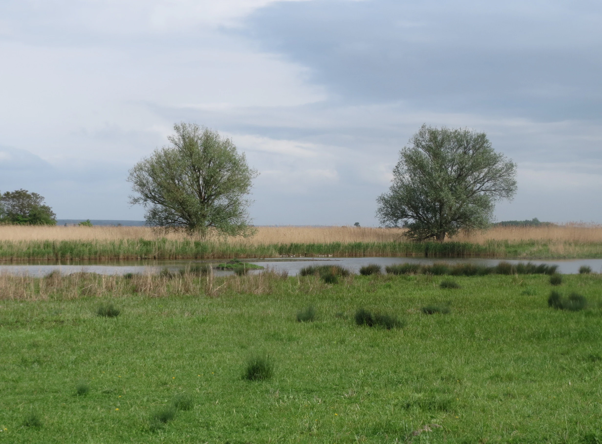
A peaceful landscape view of a marshy wetland area with a small pool of water, patches of grass, and two prominent trees under an overcast sky.
A view of the wetland area within the Der Spieß nature reserve.

Der Spieß, An der Spießbrücke Nature Reserve history and protected-area timeline

The legal protection of Der Spieß – An der Spießbrücke dates to 26 September 1985, when the Bezirksregierung Rheinhessen-Pfalz issued the formal Re Right Ordinance establishing the area as a Naturschutzgebiet for the purpose of species and biotope protection. Its designation came well after the dramatic transformation of the surrounding floodplain: in 1936 a general drainage plan had set out the drying of the old Rhine arm in this part of the Upper Rhine to free up land for agriculture, replacing the natural wetland mosaic with fields.

Those drained fields continued to suffer from high groundwater tables and recurring waterlogging during heavy rainfall, so from 2002 onward, plots neighboring the nature reserve were taken out of agricultural use on Rheindürkheim municipal land. The Seegraben was renaturalized, and the area of land now used for habitat protection was expanded to roughly 20 hectares of former cropland. As a result, today's reserve sits at the center of an actively restored floodplain landscape rather than standing in isolation, and it reflects both the protection history of 1985 and the long-running rewetting story of the surrounding old Rhine corridor.

Der Spieß, An der Spießbrücke Nature Reserve landscape and geographic character

The reserve lies in a verlandeter, or silted-up, former arm of the Rhine, producing a shallow, low-lying floodplain landscape characteristic of the Upper Rhine lowlands. The protected area itself is approximately rectangular in shape and is dominated by a gentle mosaic of wet terrain rather than dramatic relief. Open water is present but thread-like, defined by drainage ditches and the slow, meandering character of the old channel.

The hydrology of the site is shaped by the Seegraben, which branches off from the Seebach and runs along the southwest side of the reserve before draining toward the Rhine via Eich. To the north, beyond the protected boundary, the Mückenhäuser Hof farmstead anchors the transition between the wetland and the surrounding agricultural plain. Together these features give the reserve a setting that reads visually as a quiet pocket of floodplain wetland embedded in a flatter, cultivated Rhine-side landscape.

Der Spieß, An der Spießbrücke Nature Reserve ecosystems, habitats, and plant life

Ecologically, the reserve is defined by its wetland plant communities, which together recreate the classic vegetation mosaic of a former Rhine oxbow. The biotope mapping carried out in 2007 documented three principal plant communities across the site: a reed canary-grass-dominated Phalaridetum arundinaceae stand, a tall-reed Phragmition australis community typical of deeper water margins, and a Cicuto-Caricetum pseudocyperi sedge community associated with fluctuating water levels and wet meadows.

Alongside these dominant communities, the reserve contains a network of water-filled ditches, extensive reedbeds (Schilfröhricht), sedge stands (Seggenrieder), and open wet meadows (Feuchtwiesen). Together they build up a structurally diverse wetland that combines open water, emergent vegetation, and grassy marshland, which is precisely the habitat combination that many water-dependent bird species need for roosting and feeding. The presence of reconnecting wet features on former cropland in the wider Rheindürkheim area further strengthens the ecological continuity of this wetland landscape.

Der Spieß, An der Spießbrücke Nature Reserve wildlife and species highlights

The reserve's primary wildlife significance lies in its role as a resting and feeding area for rare bird species along the Upper Rhine. The combination of reedbeds, sedge stands, and wet meadows arranged around shallow open water makes Der Spieß a stopping point where birds can find cover, food resources, and relatively undisturbed roosting conditions amid an otherwise heavily agricultural landscape.

Ornithological observations published in 'Pflanzen und Tiere in Rheinland-Pfalz' (volume 18, 2007) by Matthias Bösl specifically highlight the development of the site into a significant wetland for birds in the Worms area, underscoring the reserve's recognized importance for wetland avifauna. While the source material focuses on birdlife rather than other animal groups, the largely undisturbed, water-rich character of the habitat also supports the typical invertebrate, amphibian, and small-mammal communities expected of an old Rhine oxbow wetland of this type.

Der Spieß, An der Spießbrücke Nature Reserve conservation status and protection priorities

The reserve was established specifically for species and biotope protection, reflecting the recognition that even very small wetlands in an intensively used region can carry disproportionate ecological value. By safeguarding a relict segment of an old Rhine arm with its associated reedbeds, sedge stands, and wet meadows, the site helps preserve habitat types that have largely disappeared from the surrounding Upper Rhine plain under decades of drainage and agricultural conversion.

Beyond its own boundaries, the reserve's conservation role is reinforced by its inclusion in the broader Rheinhessisches Rheingebiet landscape protection area, which buffers the core wetland with additional landscape-level protections. The adjacent rewetting of roughly 20 hectares of former cropland on Rheindürkheim land, beginning in 2002 and accompanied by the renaturalization of the Seegraben, has further strengthened the conservation context, gradually restoring a more continuous wetland system around the protected core.

Top sights and standout views in Der Spieß, An der Spießbrücke Nature Reserve

The defining qualities of the reserve are the small but unusually intact wetland mosaic of reedbeds, sedge stands, and wet meadows within a former Rhine oxbow north of Worms; its formal species- and biotope-protection designation dating from 1985; its role as a recognized resting site for rare wetland birds; and its integration into the ongoing Rhine floodplain rewetting story, in which neighboring farmland has been progressively restored to wetland habitat since 2002.

Equally notable is the reserve's character as a living reference for the pre-1936 state of the old Rhine channel here, before large-scale drainage reshaped the floodplain. That historical depth, combined with active habitat restoration in the surrounding Rheindürkheim area, gives the site a strong sense of place despite its compact size.

Best time to visit Der Spieß, An der Spießbrücke Nature Reserve

Because the reserve is a small wetland, visit timing is best understood through the seasonal rhythm of Rhine floodplain birdlife and vegetation rather than through access logistics. Spring and early summer tend to bring vigorous growth in the reedbeds and sedge stands, and many wetland birds are most actively present in and around the reserve during these months. Late summer and autumn often coincide with the post-breeding gathering of waterbirds and with broader migration traffic along the Upper Rhine, while winter can bring quieter conditions and a more open, frost-edged view of the wetland structure. Any visit that aims to experience the site's character as a bird refuge will benefit from choosing the seasons when wetland bird activity in the Upper Rhine is at its peak.


Monthly climate preview

Long-term representative point measurements of annual temperature and precipitation

Naturschutzgebiet Der Spieß – An der Spießbrücke Climate Normals and Weather by Month

Representative coordinate records show measured monthly temperature ranges and steady precipitation averages across the protected area. Examining the complete twelve-month profile reveals detailed baseline climate patterns for the location.
Annual mean10 °C
0 °C20 °C
Jan
Feb
Mar
Apr
May14°
Jun18°
Jul20°
Aug20°
Sep15°
Oct10°
Nov
Dec
Warmest month
July

20.4 °C

Coolest month
January

0.3 °C

Wettest month
July

2.2 mm/day

Driest month
April

1.4 mm/day

Park location guide

Geography guide, regional context, and park location map for Der Spieß, An der Spießbrücke Nature Reserve

Der Spieß, An der Spießbrücke Nature Reserve park geography, regions, and map view in Germany

Understand where Der Spieß, An der Spießbrücke Nature Reserve sits in Germany through a broader geographic reading of the surrounding landscape, nearby location context, and its mapped position within the national park landscape.

How Der Spieß, An der Spießbrücke Nature Reserve fits into Germany

Germany is a federal republic in Western and Central Europe with a population of over 83 million across sixteen constituent states. It is Europe's largest economy by nominal GDP and a major global exporter and importer. The capital is Berlin, and the country borders Denmark, Poland, Czech Republic, Austria, Switzerland, France, Luxembourg, Belgium, and the Netherlands.

Wider geography shaping Der Spieß, An der Spießbrücke Nature Reserve in Germany

Germany is located in Western and Central Europe, spanning 357,022 km². It borders Denmark to the north, Poland and the Czech Republic to the east, Austria and Switzerland to the south, and France, Luxembourg, Belgium, and the Netherlands to the west. The country has coastlines on the Baltic Sea and North Sea to the north, with the Alps located in the southern region.

Map view of Der Spieß, An der Spießbrücke Nature Reserve

Use this park location map to pinpoint Der Spieß, An der Spießbrücke Nature Reserve in Germany, understand its exact geographic position, and read its mapped placement within the surrounding landscape more clearly.

Pigeon | © OpenStreetMap contributors

Location context for Der Spieß, An der Spießbrücke Nature Reserve

Rhineland-Palatinate

Visual exploration of wetland habitats, reedbeds, and protected floodplain terrain

Naturschutzgebiet Der Spieß – An der Spießbrücke Photos and Landscape Scenery

Visual documentation captures the shallow wetland mosaic, open water channels, and wet meadows that define the protected nature reserve. Examining these photographic records reveals the ecological character of the old Rhine oxbow and its surrounding floodplain environment.

A peaceful landscape view of a marshy wetland area with a small pool of water, patches of grass, and two prominent trees under an overcast sky.

Park atlas

Compare regional wetland habitats and connected floodplain reserves across the Upper Rhine corridor

Parks Near Naturschutzgebiet Der Spieß – An der Spießbrücke and Surrounding Protected Areas

Browsing other parks near Naturschutzgebiet Der Spieß – An der Spießbrücke reveals broader ecological patterns across the regional floodplain landscape. Expanding the protected-area comparison helps contextualize local wetland habitats within the wider Upper Rhine valley network.
A horizontal watercolor painting showing a soft green landscape with meadows, low-lying trees, and distant hills under a light sky.
Nature reserveHesse
About 5.8 km away#1 closest

Southeast

Lochwiesen von Biblis Nature Reserve: Geographic Overview and Protected Landscape Mapping

Rhine valley meadow conservation in the Hessisches Ried of southern Hesse.

Lochwiesen von Biblis serves as a protected sanctuary for riverine ecosystems in the Upper Rhine lowlands. This nature reserve provides essential habitat for lowland meadows and wet grassland species, offering a window into the natural floodplain dynamics that once defined the entire Hessian Rhine corridor. Explore the structural boundaries of this conservation area and its place in the larger regional landscape.

Area
0.511 km²
Established
1992
IUCN
IV
A soft watercolor painting of a winding river flowing through a lush green floodplain with distant hills under a pale sky.
Nature reserveHessen
About 7.6 km away#2 closest

Northeast

Kühkopf-Knoblochsaue Nature Reserve: A Detailed Look at Hessian Rhine Floodplain Geography

Protected river island terrain, alluvial forests, and floodplain dynamics

Examine the geographic characteristics of Kühkopf-Knoblochsaue, the premier nature reserve in the Hessian Ried. This site provides an in-depth atlas perspective on the Rhine floodplain, featuring the iconic inland island structure, softwood and hardwood forest transitions, and the ongoing influence of the Stockstadt-Erfelder Altrhein on the local terrain.

Area
24.4 km²
Established
1952
Relief
Lowland
Climate
Temperate
Nature reserveRhineland-Palatinate
About 13 km away#3 closest

South

Wormser Ried Nature Reserve: Mapped Landscape and Protected Area Context

A wetland mosaic in the Rhineland-Palatinate floodplain

Situated in the southern periphery of Worms, the Wormser Ried is a compact, embanked nature reserve defined by its history as an industrial settling area. The site represents a distinct, internally managed wetland system comprising ponds, reed belts, and softwood alluvial forest fragments that support regional biodiversity within an otherwise developed landscape.

Area
0.353 km²
Established
1968
Relief
Lowland
Climate
Temperate
Nature reserveRheinland-Pfalz
About 14 km away#4 closest

Northwest

Gau-Köngernheimer Ried Nature Reserve: Map and Protected Landscape Geography

A protected wetland mosaic in the Selz river valley of Rheinland-Pfalz

Gau-Köngernheimer Ried represents an ecologically vital nature reserve in the Alzey-Worms district. Its landscape is defined by a low-lying floodplain, featuring reed-fringed ditches, pollarded trees, and moist hay meadows that follow the course of the Selz river. The site functions as a key component of the regional habitat network within the agricultural landscape of southwestern Germany.

Area
0.29 km²
Established
1990
Relief
Lowland
Climate
Temperate
A soft watercolor painting showing a winding river through a green landscape with soft, rolling hills in the background under a pale sky.
Nature reserveHessen
About 14 km away#5 closest

South

Naturschutzgebiet Lampertheimer Altrhein: Mapped Wetland Nature Reserve in Hessen Germany

Historic Rhine meander and protected bird sanctuary landscape

The Naturschutzgebiet Lampertheimer Altrhein stands as a landmark of floodplain conservation in Hessen, protecting a large-scale former Rhine meander. This reserve integrates shallow oxbow lakes, extensive wet grasslands, and riparian forest into a coherent mosaic of habitats, offering a detailed glimpse into the ecological evolution of the Upper Rhine valley.

Area
5.156 km²
Established
1937
IUCN
IV
Relief
Lowland
A soft, painterly watercolor illustration depicting a winding river flowing through a lush green valley with rolling hills in the background.
Nature reserveRheinland-Pfalz
About 15 km away#6 closest

Northwest

Im Briehl/Schafwiese Nature Reserve: Selz River Floodplain and Wetland Geography

A restored riverine landscape in Rheinland-Pfalz

The Im Briehl/Schafwiese nature reserve is a protected fragment of the Selz river floodplain in Rheinland-Pfalz. This site is defined by its 2020 to 2021 renaturation, which replaced straight channels with a meandering course, creating a mosaic of damp meadows, reed beds, and still-water biotopes within an agricultural landscape.

Area
0.23 km²
Established
1990
A soft, delicate watercolor painting depicting a meandering river flowing through a lush, grassy wetland landscape with rolling hills in the background.
Nature reserveHessen
About 16 km away#7 closest

East

Altneckarlachen von Alsbach, Hähnlein und Bickenbach: Protected Wetland and River Geography

A rare mosaic of prehistoric river loops in the Hessian Rhine plain

Altneckarlachen von Alsbach, Hähnlein und Bickenbach protects a unique sequence of prehistoric Neckar meanders featuring shallow water zones, reed belts, and black-alder swamp forest. This nature reserve in the Darmstadt-Dieburg district remains a critical wetland sanctuary, preserving a vital ecological cross-section of the ancient Rhine-Neckar landscape and its associated peatland soils.

Area
0.892 km²
Established
1990
IUCN
IV
Relief
Lowland
A watercolor painting showing a soft, stylized landscape of green meadows, sparse trees, and distant rolling hills against a white background.
Nature reserveHesse
About 17 km away#8 closest

East

Im Dulbaum bei Alsbach Nature Reserve: Mapped Inland Dunes and Grassland Geography

A vital protected sandy terrain in the Hessian Rhine Plain

Im Dulbaum bei Alsbach protects a remnant of the historic Rhine graben sand dune belt in southern Hesse. This nature reserve provides essential habitat connectivity for heat-loving species through its distinct calcareous sand grasslands and former quarry terrain, offering a look into the region's complex ecological history.

Area
0.092 km²
Established
1994
IUCN
IV
Relief
Lowland

Common questions about visiting, size, designation, and location context for Der Spieß, An der Spießbrücke Nature Reserve

Der Spieß, An der Spießbrücke Nature Reserve FAQs for park facts, access, geography, and protected area context

Find quick answers about Der Spieß, An der Spießbrücke Nature Reserve, including protected-area facts, park geography, trail and visitor context, and how the park fits into its surrounding country and regional landscape.
MoriAtlas Explorer

Continue Your Protected Areas Search Across the Global Atlas

Deepen your exploration by continuing the structured search for national parks and protected areas worldwide. Utilize the comprehensive filtering capabilities to compare different conservation landscapes and refine your understanding of global park geography. Discover more about the distribution and characteristics of protected natural areas.

Global natural geography