
Mori Atlas logo
Nature reserveDie Heck bei Hohenroth

Tracing the high-elevation deciduous forest mosaic within the Hoher Westerwald regional upland

Die Heck bei Hohenroth Nature Reserve: Mapped Protected Landscapes in Hessen, Germany

(Naturschutzgebiet Die Heck bei Hohenroth)

Die Heck bei Hohenroth stands as a significant nature reserve within the Hohen Westerwald region of Hessen, representing a compact 20-hectare block of protected broadleaf forest. Situated at an elevation of 550 metres, this area showcases a complex micro-topography where dry ridges contrast with saturated hollows. As part of the wider Natura 2000 network, this site preserves near-natural woodland processes and essential deadwood habitats in the central German Mittelgebirge.

broadleaf forestMittelgebirgehighland woodlanddeadwood habitatsHessenLahn-Dill-Kreis
A stylized vector illustration of a forested landscape featuring a waterfall cascading down a cliff face, a dirt trail in the foreground, and a communications tower on a distant hillside under a sunset sky.

Die Heck bei Hohenroth

Nature reserve

Park overview

Structured park overview, official facts, and landscape profile for Die Heck bei Hohenroth

Die Heck bei Hohenroth park facts, protected area profile, and essential visitor context

Review the core facts for Die Heck bei Hohenroth, including designation, size, terrain, visitor scale, habitats, and operating context in one park-focused overview.

About Die Heck bei Hohenroth

Die Heck bei Hohenroth is a small but ecologically focused nature reserve in the Hohen Westerwald, part of the broader German Mittelgebirge landscape in central Hesse. Although its area is modest at roughly 20 hectares, the reserve protects a coherent block of broadleaf forest that reflects the natural forest character of the higher Westerwald ridges.

The woodland sits at elevations typical of the upper Westerwald, averaging around 550 metres above sea level. This height produces a distinctly cool and moist forest climate, with annual precipitation above 1,000 millimetres, conditions that shape both the tree species composition and the understorey vegetation. Within the small area, the ground varies from dry ridges through intermittently wet zones to permanently waterlogged hollows, producing a fine-grained mosaic of forest habitats.

Beyond its intrinsic value, the reserve is embedded in a much larger European conservation framework. Its full surface lies within the FFH site "Hoher Westerwald" (5314-301) and the corresponding European Birds Directive site (5314-450), making it part of a continuous protected forest landscape shared with neighbouring reserves in the Lahn-Dill district. While the site is small, its inclusion in these networks gives it relevance for forest development, woodland bird conservation and the protection of deadwood-rich habitats typical of old-growth broadleaf forests in the region.

Quick facts and research context for Die Heck bei Hohenroth

Die Heck bei Hohenroth is a Hessian nature reserve (Naturschutzgebiet) in the Lahn-Dill district, officially designated on 12 August 1998 under identifier 1532040. It is administered by the Regierungspräsidium Giessen as the higher nature protection authority.

The site covers about 20.43 hectares of closed deciduous forest at around 550 metres elevation within the Hohen Westerwald, near the Krombach reservoir and the Höllberg peak. It forms part of the EU-protected FFH site "Hoher Westerwald" (5314-301) and the associated European Bird Directive area with the same name (5314-450). Its IUCN category is IV, denoting a habitat and species management area focused on natural woodland processes.

Protection and recognition

Documented conservation records and official protected area attributes

Die Heck bei Hohenroth Protection Status and International Recognition Data

Die Heck bei Hohenroth protection status and recorded administrative boundaries offer structured insight into documented conservation parameters. Official database registry records outline the available protection metrics and administrative context for this protected landscape.

Protection details

WDPA ID
318291
Park context

Deeper park guide and search-rich context for Die Heck bei Hohenroth

Die Heck bei Hohenroth history, landscape, wildlife, and travel context

Explore Die Heck bei Hohenroth through its history, landscape character, ecosystems, wildlife, conservation priorities, cultural context, and seasonal travel timing in a structured park guide built for atlas discovery and search intent.

Why Die Heck bei Hohenroth stands out

The reserve is best known for being a compact, high-elevation stand of broadleaf forest in the Hohen Westerwald, where dry ridges, intermittent wet hollows and permanently saturated ground come together within a single small woodland block. It is also recognised for its position within the larger Hoher Westerwald FFH and Birds Directive complex, linking it into the European network of protected woodland habitats. The combination of cool, wet Mittelgebirge climate and a varied micro-topography gives the area a structurally rich broadleaf woodland with old trees and abundant deadwood, providing habitat for fungi, lichens, insects and forest birds.
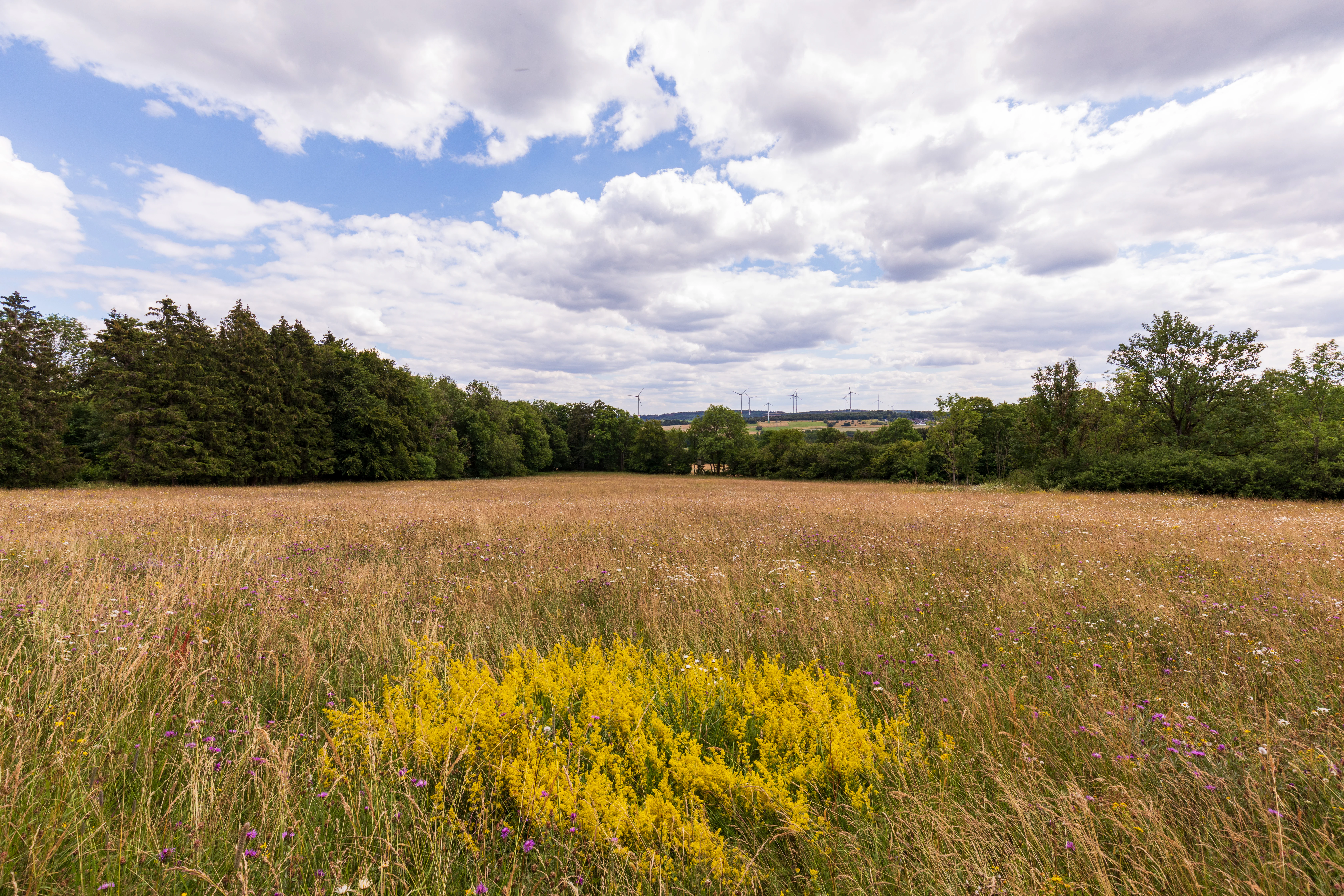
A wide view of a sunlit meadow with tall, dry grass and a cluster of bright yellow wildflowers in the foreground, backed by a dense line of deciduous trees under a cloudy sky.
A meadow in Die Heck bei Hohenroth nature reserve, featuring wild grasses, wildflowers, and bordering forest.

Die Heck bei Hohenroth history and protected-area timeline

Die Heck bei Hohenroth was formally placed under nature protection on 12 August 1998 under Hessian state regulation, receiving the official identifier 1532040. From the start, the reserve was conceived not as an isolated patch but as part of the broader landscape-level conservation effort in the Hohen Westerwald.

Its full integration into the FFH site "Hoher Westerwald" (5314-301) and the European Birds Directive area "Hoher Westerwald" (5314-450) reflects the wider Natura 2000 strategy for the region. In 2013, a management plan was drawn up for the FFH area, prescribing for this nature reserve a course of natural woodland development without active forestry or further management interventions, allowing ecological processes to drive the forest's future structure.

Die Heck bei Hohenroth landscape and geographic character

The reserve sits in the Hohen Westerwald, a high rolling upland that forms part of the German Mittelgebirge. To the north rises the Höllberg at about 643 metres above sea level, a notable local peak, while the Krombach reservoir lies to the southwest. Between these features, the protected woodland occupies a gently sloping block at around 550 metres elevation.

The terrain of the reserve itself is shaped by small-scale changes in drainage and soil moisture. Dry upper slopes contrast with seasonally wet depressions and permanently damp hollows, producing a varied micro-topography even within the compact forest footprint. Near-natural forest edges frame the woodland, transitioning outward into open agricultural grassland pastures that border the protection area on several sides.
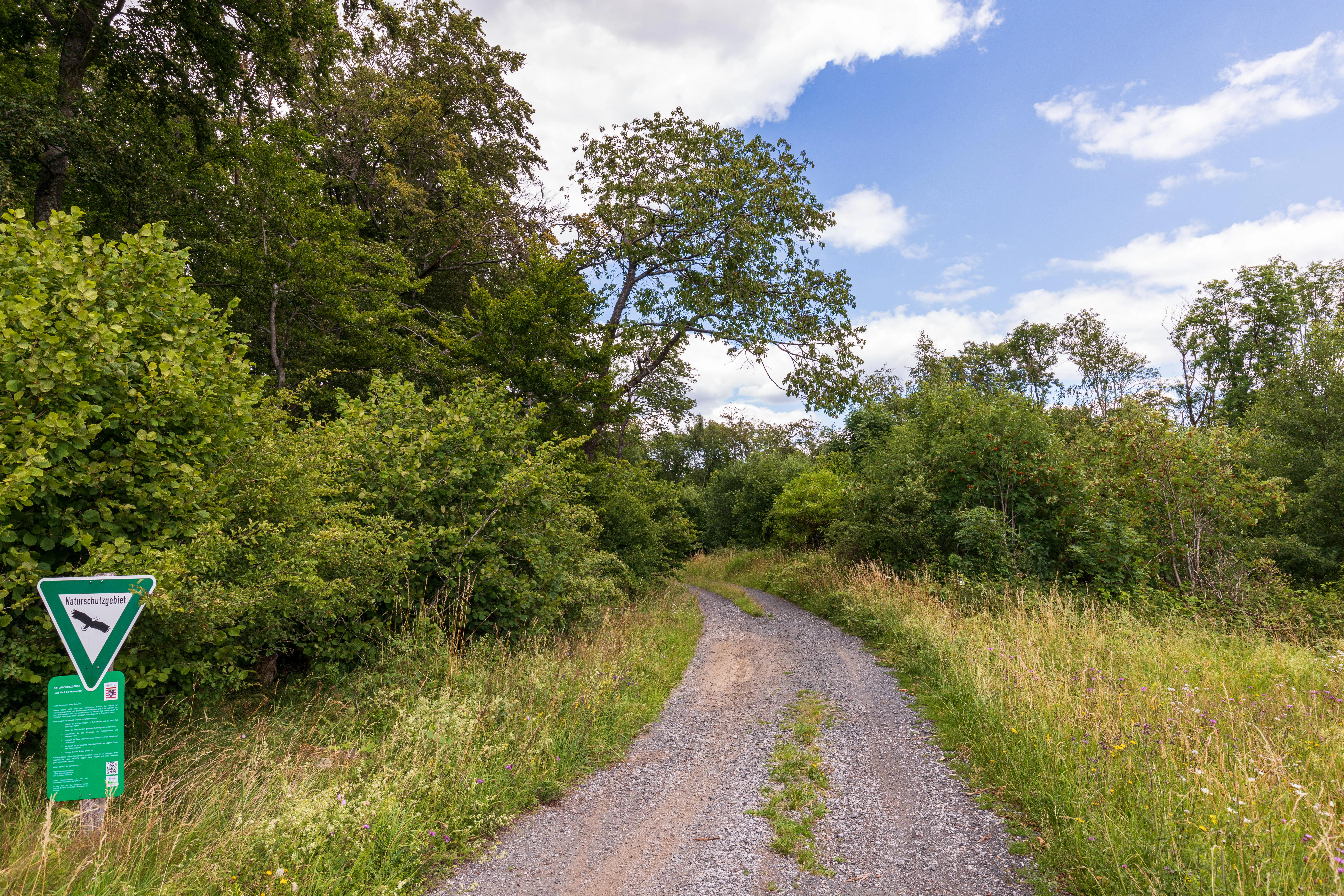
A gravel path winds into a deciduous forest, with a green nature reserve sign on a post in the left foreground.
A gravel trail leading into the forest at Die Heck bei Hohenroth nature reserve.

Die Heck bei Hohenroth ecosystems, habitats, and plant life

Ecologically, Die Heck bei Hohenroth is a closed broadleaf forest (Laubwald) reserve whose character is defined by the combination of high elevation, abundant rainfall and a wet-cool Mittelgebirge climate. Annual precipitation above 1,000 millimetres sustains consistently moist soils and supports a moss- and herb-rich forest interior.

The site's particular ecological interest lies in its habitat diversity within a small area. Dry, intermittently wet and permanently saturated stands occur side by side, each supporting different plant communities. Retained deadwood and old trees are integral to the reserve's nature value, providing critical habitats for woodland fungi, lichens, saproxylic insects and cavity-nesting or deadwood-dependent bird species that rely on undisturbed, structurally rich forest environments.
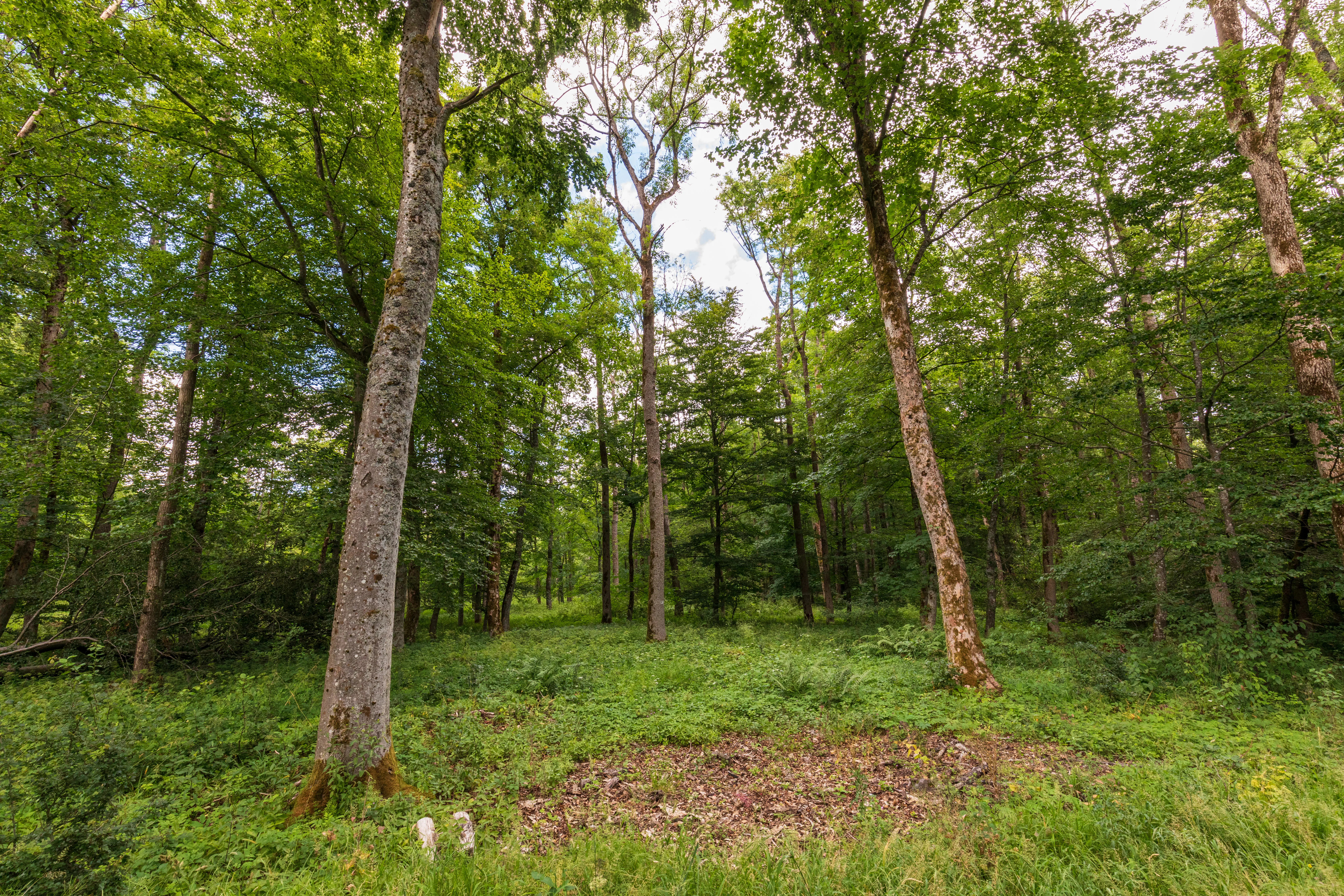
Eye-level shot looking into a lush green deciduous forest with tall tree trunks and dense foliage.
A view into the dense, deciduous forest of the Die Heck bei Hohenroth nature reserve.

Die Heck bei Hohenroth wildlife and species highlights

The reserve's wildlife profile is shaped by its character as a moist, mature broadleaf forest with abundant deadwood. Such conditions support a community of woodland species rather than open-country fauna, and the emphasis in the source material is on functional habitat provision rather than headline species lists.

Old trees and standing or fallen deadwood within the reserve create habitats for fungi, lichens and insects, which in turn sustain forest birds that depend on old-growth structural features. The integration of the area into the Hoher Westerwald Birds Directive site underscores the landscape's role for woodland and forest-edge bird communities at a European scale.

Die Heck bei Hohenroth conservation status and protection priorities

From a conservation perspective, Die Heck bei Hohenroth is significant not for its size but for the integrity of its forest processes within a broader protected landscape. Its full inclusion in the FFH site "Hoher Westerwald" and the corresponding Birds Directive area places it firmly within the Natura 2000 network and links its small woodland block to continuous protected forest across the region.

The 2013 management plan for the FFH area formalises a hands-off approach: the reserve is designated for natural forest development, with no further forestry use and no regular active management interventions. This strategy prioritises the long-term accumulation of deadwood, the aging of the tree stands and the natural regeneration of the broadleaf forest, which in turn sustains the fungi, lichens, insects and forest birds that depend on these processes.

Top sights and standout views in Die Heck bei Hohenroth

One of the reserve's standout qualities is the concentration of dry, intermittently wet and permanently wet forest micro-habitats into a small, high-elevation woodland block, unusual within such a compact area.

Equally distinctive is its governance approach: rather than active forestry, the area is being allowed to develop as a natural broadleaf forest with old trees and abundant deadwood. Combined with its full inclusion in the Hoher Westerwald FFH and Birds Directive sites, the reserve functions as a small but ecologically meaningful node within a much larger European forest protection network.

Monthly climate preview

Long-term representative monthly temperature and precipitation rhythm

Die Heck bei Hohenroth Climate Normals and Annual Weather Patterns

Die Heck bei Hohenroth sustains measured monthly temperature variations alongside steady daily precipitation patterns across the recorded baseline period. Analyzing the complete twelve-month climatology dataset reveals broader seasonal trends and detailed baseline averages for this Hessen location.
Annual mean9 °C
0 °C19 °C
Jan
Feb
Mar
Apr
May12°
Jun16°
Jul19°
Aug18°
Sep14°
Oct
Nov
Dec
Warmest month
July

18.5 °C

Coolest month
January

-0.4 °C

Wettest month
December

2.5 mm/day

Driest month
April

1.6 mm/day

Park location guide

Geography guide, regional context, and park location map for Die Heck bei Hohenroth

Die Heck bei Hohenroth park geography, regions, and map view in Germany

Understand where Die Heck bei Hohenroth sits in Germany through a broader geographic reading of the surrounding landscape, nearby location context, and its mapped position within the national park landscape.

How Die Heck bei Hohenroth fits into Germany

Germany is a federal republic in Western and Central Europe with a population of over 83 million across sixteen constituent states. It is Europe's largest economy by nominal GDP and a major global exporter and importer. The capital is Berlin, and the country borders Denmark, Poland, Czech Republic, Austria, Switzerland, France, Luxembourg, Belgium, and the Netherlands.

Wider geography shaping Die Heck bei Hohenroth in Germany

Germany is located in Western and Central Europe, spanning 357,022 km². It borders Denmark to the north, Poland and the Czech Republic to the east, Austria and Switzerland to the south, and France, Luxembourg, Belgium, and the Netherlands to the west. The country has coastlines on the Baltic Sea and North Sea to the north, with the Alps located in the southern region.

Map view of Die Heck bei Hohenroth

Use this park location map to pinpoint Die Heck bei Hohenroth in Germany, understand its exact geographic position, and read its mapped placement within the surrounding landscape more clearly.

Pigeon | © OpenStreetMap contributors

Location context for Die Heck bei Hohenroth

Hessen

Visualizing highland woodland habitats and protected forest terrain in the German uplands

Die Heck bei Hohenroth Photos and Landscape Scenery

Visual records illustrate the complex mosaic of dry ridges, wet hollows, and dense broadleaf canopies defining the terrain of Die Heck bei Hohenroth. Detailed photographic coverage reveals the ecological character of high-elevation woodland habitats across the protected Mittelgebirge landscape.

A wide view of a sunlit meadow with tall, dry grass and a cluster of bright yellow wildflowers in the foreground, backed by a dense line of deciduous trees under a cloudy sky.

A wide, golden-grass meadow in the foreground leads to a dense line of coniferous forest; a tall communications tower is visible in the distant background under a bright, cloudy sky.

A gravel path winds into a deciduous forest, with a green nature reserve sign on a post in the left foreground.

Eye-level shot looking into a lush green deciduous forest with tall tree trunks and dense foliage.

Park atlas

Compare adjacent highland woodland reserves and regional protected areas in the central German uplands.

Other Parks Near Die Heck bei Hohenroth and Surrounding Protected Landscapes

Explore nearby protected areas sharing the upland terrain and broadleaf woodland characteristics of Die Heck bei Hohenroth. Comparing these adjacent nature reserves reveals how regional geography shapes forest habitats across the surrounding Mittelgebirge uplands.
Watercolor painting of a soft, hazy landscape featuring gentle green hills, clusters of trees, and open fields against a white background.
Nature reserveHessen
About 1.5 km away#1 closest

North

Bermershube bei Heisterberg Protected Area: Geography and Landscape Atlas

Nature reserve in the Hoher Westerwald region of Hessen

Located in the Lahn-Dill district, Bermershube bei Heisterberg represents a concentrated mosaic of upland natural features. The protected landscape combines deciduous slope forests with spring-fed wetlands and meadows, creating an essential ecological corridor within the Hoher Westerwald plateau. Detailed geographic insights reveal the interplay between the Amdorf brook drainage and the surrounding undisturbed forest ecosystems.

Area
0.449 km²
Established
1984
IUCN
IV
Relief
Upland
A horizontal watercolor painting depicting a soft, impressionistic landscape with rolling hills in the background and a line of green trees and meadow in the foreground.
Nature reserveHessen
About 3.4 km away#2 closest

Northwest

Feuerheck bei Waldaubach Nature Reserve: Upland Forest and Habitat Geography in Hessen

Protected broadleaf woodland landscapes and high-elevation habitat patterns.

Located in the German central highlands of Hessen, Feuerheck bei Waldaubach stands as a meticulously protected 24-hectare nature reserve. The site features a sophisticated interplay of deciduous woodland and moist meadow clearings, driven by high annual rainfall and varied soil conditions. This atlas entry provides essential data on the reserve's topography, forest management status, and its role as a key habitat for specialized invertebrates and woodland birds.

Area
0.244 km²
Established
1984
IUCN
IV
A soft watercolor painting showing green rolling hills in the foreground and faded purple and yellow mountain silhouettes against a white background.
Nature reserveRhineland-Palatinate
About 4.4 km away#3 closest

Northwest

Fuchskaute Nature Reserve: Topographic Atlas and Protected Landscape Overview

Highland basalt summit of the Westerwald range in Rhineland-Palatinate

Fuchskaute represents a primary geographic landmark and nature reserve in the Hoher Westerwald. The site features an ancient, erosion-resistant basalt cap that supports rare upland heaths and species-rich meadows, distinct from the surrounding Devonian sediments. Our atlas data tracks its complex overlapping conservation status and provides a clear view of its summit plateau and surrounding hydrographic networks.

Area
0.402 km²
Established
1984
Relief
Mountain
Climate
Temperate
Nature reserveRheinland-Pfalz
About 4.4 km away#4 closest

Southwest

Wacholderheide bei Westernohe Nature Reserve Protected Area Atlas and Geographic Map Context

Juniper heathland mosaic in the German Westerwald region

Spanning 14 hectares, Wacholderheide bei Westernohe acts as a vital protected pocket of open heathland framed by dense spruce forests. The reserve supports a specialized community of arnica, common heather, and juniper, sustained by decades of consistent grazing and mechanical mowing that define its unique regional character.

Area
0.14 km²
Established
1967
IUCN
IV
Watercolor painting of a soft, hazy landscape featuring rolling green hills, distant mountains, and water in the foreground.
Nature reserveWesterwaldkreis
About 4.5 km away#5 closest

West

Breitenbachtalsperre Nature Reserve: Geography and Protected Habitat Mapping in Westerwaldkreis

Managed wetland and reservoir landscape in western Germany

Breitenbachtalsperre protects an important reservoir ecosystem, including shallow margins and wet meadows near Waigandshain. This nature reserve provides a focused look at habitat management in the Westerwald, where stream-fed waters sustain diverse plant societies and wildlife in a compact, protected basin.

Area
0.47 km²
Established
1988
IUCN
IV
A watercolor illustration of a forest edge with trees, mossy rocks, and ferns, featuring a soft, bright, and airy color palette.
Nature reserveHessen
About 5.5 km away#6 closest

North

Rabenscheider Holz Nature Reserve: Protected Landscapes and Stream Valleys in Hessen

Westerwald upland terrain and diverse woodland habitats

Rabenscheider Holz preserves a vital cross-section of Westerwald habitats, integrating mature broadleaf forests and traditionally managed grasslands. This nature reserve serves as an ecological anchor within the Ketzerbach stream valley, maintaining important woodland and meadow biodiversity in the state of Hessen.

Area
0.573 km²
Established
1994
IUCN
IV
A soft, painterly watercolor illustration of a rolling green landscape with a gentle stream or wetland area in the foreground and rounded hills in the background.
Nature reserveHessen
About 6.3 km away#7 closest

North

Aubachtal bei Rabenscheid Nature Reserve: Mapped Geography and Protected Area Data

A primary stream-valley habitat within the Hessen region

Aubachtal bei Rabenscheid offers a detailed look at a high-quality nature reserve in the Lahn-Dill-Kreis area of Hessen. The landscape is defined by the narrow valley of the Aubach, which supports a complex mosaic of wet meadows, alder swamp woodlands, and sedge mires. This site functions as a significant ecological refuge, contributing to the broader European network of protected areas through its distinct biodiversity and clean-water stream ecosystems.

Area
0.63 km²
Established
1984
IUCN
IV
Relief
Upland
Watercolor illustration of a winding stream flowing through a lush green valley with rolling hills in the background.
Nature reserveRheinland-Pfalz
About 12 km away#8 closest

Southwest

Holzbachdurchbruch: Basalt Gorge and Protected Nature Reserve in the Westerwald Highlands

Geological landscapes and protected stream valleys in Rheinland-Pfalz.

The Holzbachdurchbruch nature reserve is a focused, high-relief landscape defined by its classic breakthrough valley where the Holzbach cuts through resistant basalt bedrock. This protected area offers a look at the volcanic terrain and forest-stream mosaics that define the Westerwald, serving as a landmark site for understanding the regional geography and geological heritage of Germany.

Area
0.21 km²
Established
1961
IUCN
IV
Relief
Upland

Common questions about visiting, size, designation, and location context for Die Heck bei Hohenroth

Die Heck bei Hohenroth FAQs for park facts, access, geography, and protected area context

Find quick answers about Die Heck bei Hohenroth, including protected-area facts, park geography, trail and visitor context, and how the park fits into its surrounding country and regional landscape.
MoriAtlas Explorer

Continue Your Protected Areas Search Across the Global Atlas

Deepen your exploration by continuing the structured search for national parks and protected areas worldwide. Utilize the comprehensive filtering capabilities to compare different conservation landscapes and refine your understanding of global park geography. Discover more about the distribution and characteristics of protected natural areas.

Global natural geography