Mori Atlas logo
Nature reserveFerbitzer Bruch

Mapping the sandy lowland terrain and ecological mosaic of this protected area in the Havelland region

Ferbitzer Bruch Nature Reserve and Protected Landscape Geography in Brandenburg, Germany

(Naturschutzgebiet Ferbitzer Bruch)

Ferbitzer Bruch represents a significant nature reserve located within the German state of Brandenburg, serving as a vital component of the broader Sielmanns Naturlandschaft Döberitzer Heide. This protected area occupies a mosaic of lowland sandy terrain, characterized by a mix of moist woodland, open ground, and transitional wetland edges. Situated between the Havel Canal and major transport corridors, it acts as a critical habitat island that preserves the distinctive ecological features of the western Brandenburg sand plains.

Brandenburgnature reserveNaturschutzgebietlowlandsandy habitatbroom

Ferbitzer Bruch

Nature reserve

Park overview

Structured park overview, official facts, and landscape profile for Ferbitzer Bruch

Ferbitzer Bruch park facts, protected area profile, and essential visitor context

Review the core facts for Ferbitzer Bruch, including designation, size, terrain, visitor scale, habitats, and operating context in one park-focused overview.

About Ferbitzer Bruch

Ferbitzer Bruch is one of the smaller but strategically placed nature reserves of western Brandenburg, anchoring a corridor of protected terrain that links the outskirts of Potsdam with the rural Havelland. Although it shares much of its ecological character with the larger Döberitzer Heide to its east, Ferbitzer Bruch has its own identity as a separately designated Naturschutzgebiet and plays a complementary role in the regional network of protected sites managed around the capital region.

The reserve sits in a transitional landscape where glacial sand plains of the Berlin-Potsdam area meet pockets of moister, more sheltered ground. This combination of dry sandy substrates and small wetter depressions supports a mix of plant communities that is typical of the Havelland lowlands, including flowering shrub communities such as broom that give the area a distinctive spring character. Visitors encounter broad open vistas interspersed with copses and shrubby thickets, threaded by walking paths that form part of the broader Naturerlebnis Ringzone experience.

Because the area lies close to major roads and the western edge of the Berlin agglomeration, Ferbitzer Bruch is also an example of how protected habitats are maintained in the immediate vicinity of significant urban pressure. The reserve demonstrates how even relatively compact protected sites, when connected to larger initiatives such as Sielmanns Naturlandschaft Döberitzer Heide, can offer meaningful habitat value and accessible nature experiences for residents of the capital region.

Quick facts and research context for Ferbitzer Bruch

Ferbitzer Bruch is a designated Naturschutzgebiet in Brandenburg, Germany, classified under IUCN Category IV as a Habitat/Species Management Area. It lies west of the Döberitzer Heide and is administratively split between the Landkreis Havelland and the city of Potsdam. Originally established by ordinance on 16 April 1996, the reserve covers a sizeable expanse of lowland terrain straddling the boundary between rural Havelland and the outskirts of Potsdam.

Protection and recognition

Documented conservation status and international designation records

Ferbitzer Bruch Protection Status and Natura 2000 Recognition Data

Ferbitzer Bruch maintains recorded protection parameters within official database registries, including Natura 2000 source entries. Structured conservation records outline the documented designation framework and international recognition data associated with this protected area.
Park context

Deeper park guide and search-rich context for Ferbitzer Bruch

Ferbitzer Bruch history, landscape, wildlife, and travel context

Explore Ferbitzer Bruch through its history, landscape character, ecosystems, wildlife, conservation priorities, cultural context, and seasonal travel timing in a structured park guide built for atlas discovery and search intent.

Why Ferbitzer Bruch stands out

Ferbitzer Bruch is best known for being the western portion of Sielmanns Naturlandschaft Döberitzer Heide and for providing accessible lowland nature experiences on the doorstep of Berlin and Potsdam. Its position between motorway, canal, and road corridors makes it a notable example of a protected habitat island preserved amid significant transportation infrastructure in western Brandenburg.
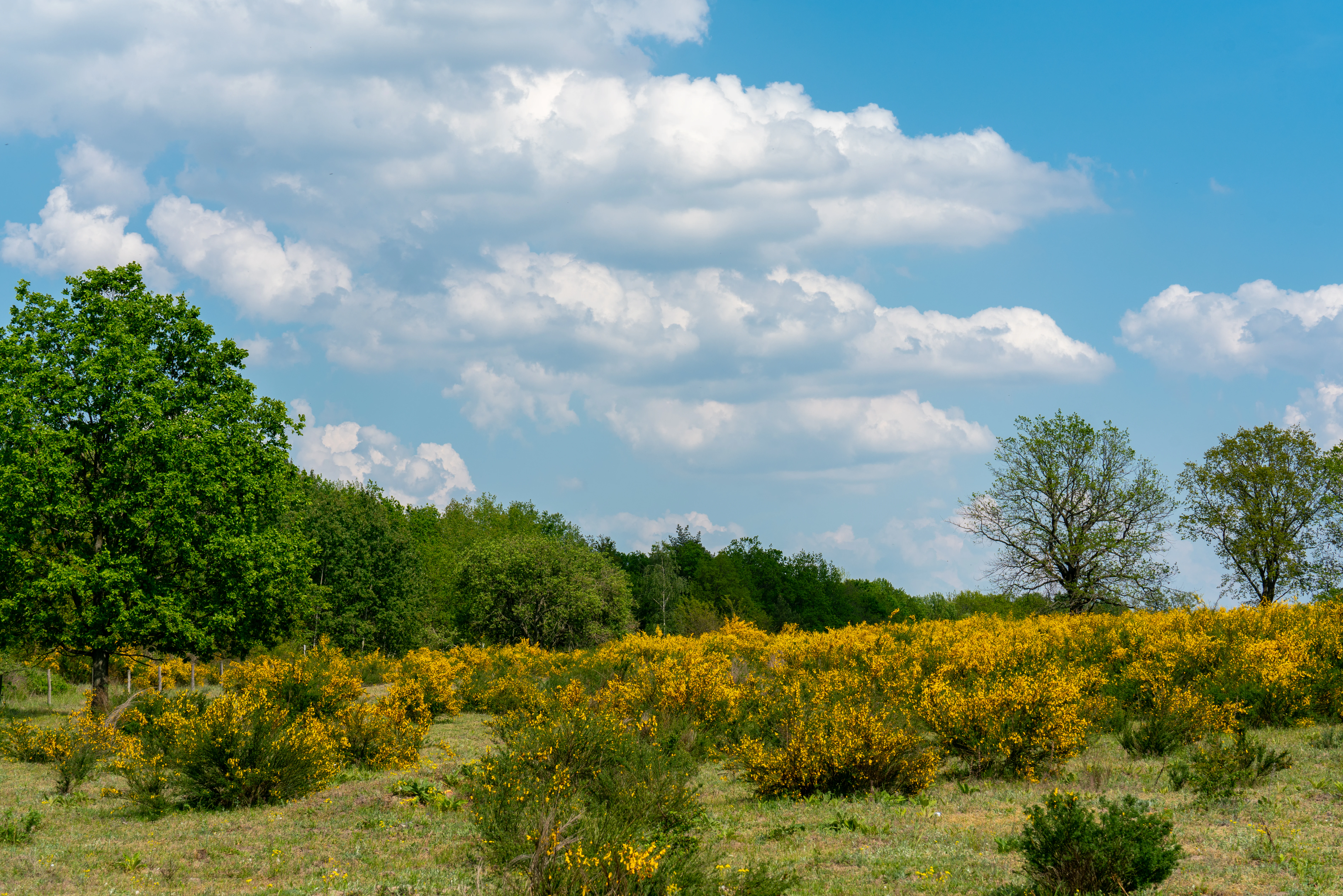
A field filled with yellow flowering broom bushes under a bright blue sky with scattered white clouds, bordered by a line of green trees.
Blooming yellow broom shrubs in Ferbitzer Bruch during spring.

Ferbitzer Bruch history and protected-area timeline

Ferbitzer Bruch was established as a Naturschutzgebiet under § 19 of the Brandenburg Nature Conservation Act of 25 June 1992. The protected-area ordinance was issued by the Minister for Environment, Nature Conservation and Spatial Planning of Brandenburg and entered into force on 16 April 1996, creating a regulated framework for the conservation of the area.

Its naming reflects the historic settlement history of the region: the reserve takes its name from the deserted village site of Ferbitz, a Wüstung lying within the adjacent Döberitzer Heide. This small, long-disappeared settlement left its mark on the local toponymy, and today its name lives on in one of the principal protected sites associated with the larger Döberitzer Heide landscape.

Ferbitzer Bruch landscape and geographic character

The reserve occupies a stretch of the western Brandenburg sand plain, a landscape shaped by glacial and periglacial processes that left behind broad stretches of sandy substrate. The terrain is generally low-lying and flat, characteristic of the lowlands west of Berlin, with subtle variations between drier sandy ridges and slightly damper hollows.

To the north the reserve is bordered by the Bundesstraße 5, while to the west run the Berliner Autobahn A 10 and the Havel Canal, both of which shape the physical and perceptual edges of the protected area. The settlement of Priort lies on its northwestern side and Fahrland on its southern side, framing the reserve between these limits. Within the protected area, paths wind through mixtures of open heath-like ground, scrub, and wooded patches, creating a mosaic that is typical of inland sandy landscapes in the region.

Ferbitzer Bruch ecosystems, habitats, and plant life

Ferbitzer Bruch represents the inland sandy and lightly moistened habitats that characterise the Havelland transition zone between the Berlin suburbs and the more open countryside to the west. The ecological value of the area lies in its combination of dry sandy substrates, scrub communities, and small damp microhabitats that together sustain a variety of plant and animal species typical of Brandenburg lowlands.

Spring in the reserve brings a notable display of broom (Ginster) flowering across open patches, a recurring seasonal feature of such sandy habitats. The vegetation mosaic supports breeding birds, invertebrates, and small mammals that depend on the mix of open ground and shrub cover, contributing to the habitat network of western Brandenburg.

Ferbitzer Bruch wildlife and species highlights

While the source material does not provide a detailed species inventory, the reserve's mosaic of sandy open ground, scrub, and woodland supports the typical fauna of inland Brandenburg lowland habitats. Such landscapes are commonly used by breeding and passage bird species, by invertebrates associated with dry sandy and heathy vegetation, and by woodland and edge species that move between the reserve and the adjoining Döberitzer Heide.

Ferbitzer Bruch conservation status and protection priorities

Ferbitzer Bruch is classified as a Habitat/Species Management Area under IUCN Category IV, a designation that reflects its role in actively protecting particular habitat types and species assemblages rather than serving as a strictly untouched wilderness reserve. Its value lies in maintaining sandy lowland habitat mosaics and connecting these to the much larger Döberitzer Heide and the Sielmanns Naturlandschaft initiative focused on that area.

By preserving a sizeable block of relatively natural terrain between motorway, canal, road, and growing settlements, the reserve also serves as a counterweight to habitat fragmentation around the Berlin-Potsdam metropolitan edge. Its inclusion in the publicly accessible Naturerlebnis Ringzone combines conservation goals with opportunities for low-impact public engagement with nature.

Ferbitzer Bruch cultural meaning and human context

The reserve carries a quiet cultural trace in its very name: Ferbitz is an abandoned medieval or early modern settlement site, a Wüstung, that once lay in or near the area now incorporated into the broader Döberitzer Heide. Although no settlement remains, the place-name persists in the designation of the protected area, anchoring the reserve to the long human history of settlement, abandonment, and land use that has shaped the Havelland landscape over centuries.

Top sights and standout views in Ferbitzer Bruch

Ferbitzer Bruch stands out as a compact but ecologically meaningful component of a much larger protected landscape, anchoring the western edge of Sielmanns Naturlandschaft Döberitzer Heide. Its combination of sandy lowland habitats, spring broom displays, and well-maintained walking paths gives it both ecological and recreational value for visitors from Potsdam, Berlin, and the surrounding Havelland.

Best time to visit Ferbitzer Bruch

Spring is a particularly expressive season in the reserve, when broom comes into flower across open patches and the mix of habitats is most visually distinctive. Cooler months of late autumn and winter can also suit visitors seeking quieter conditions in the sandy lowland terrain, while summer offers warmer walking conditions but more uniform colouration across the landscape.

Monthly climate preview

Track monthly average temperature ranges and precipitation patterns across representative terrain.

Ferbitzer Bruch Climate Normals, Long-Term Temperature and Precipitation Rhythms

Ferbitzer Bruch exhibits a measured annual temperature and precipitation rhythm derived from long-term representative coordinate records spanning multiple decades. Opening the complete monthly profile provides detailed data breakdowns for studying historical climate variations across the protected landscape.
Annual mean9 °C
-1 °C20 °C
Jan-1°
Feb
Mar
Apr
May14°
Jun18°
Jul20°
Aug20°
Sep15°
Oct
Nov
Dec
Warmest month
July

20.3 °C

Coolest month
January

-0.7 °C

Wettest month
July

2.4 mm/day

Driest month
April

1 mm/day

Park location guide

Geography guide, regional context, and park location map for Ferbitzer Bruch

Ferbitzer Bruch park geography, regions, and map view in Germany

Understand where Ferbitzer Bruch sits in Germany through a broader geographic reading of the surrounding landscape, nearby location context, and its mapped position within the national park landscape.

How Ferbitzer Bruch fits into Germany

Germany is a federal republic in Western and Central Europe with a population of over 83 million across sixteen constituent states. It is Europe's largest economy by nominal GDP and a major global exporter and importer. The capital is Berlin, and the country borders Denmark, Poland, Czech Republic, Austria, Switzerland, France, Luxembourg, Belgium, and the Netherlands.

Wider geography shaping Ferbitzer Bruch in Germany

Germany is located in Western and Central Europe, spanning 357,022 km². It borders Denmark to the north, Poland and the Czech Republic to the east, Austria and Switzerland to the south, and France, Luxembourg, Belgium, and the Netherlands to the west. The country has coastlines on the Baltic Sea and North Sea to the north, with the Alps located in the southern region.

Map view of Ferbitzer Bruch

Use this park location map to pinpoint Ferbitzer Bruch in Germany, understand its exact geographic position, and read its mapped placement within the surrounding landscape more clearly.

Pigeon | © OpenStreetMap contributors

Location context for Ferbitzer Bruch

Brandenburg

Explore detailed imagery showcasing the sandy terrain, moist woodland, and habitat mosaic of Brandenburg.

Ferbitzer Bruch Photos and Landscape Scenery: Visualizing the Lowland Protected Area

Visual documentation captures the unique topography and sandy lowland habitats defining Ferbitzer Bruch within the western Brandenburg region. Photographic records reveal the intricate mosaic of open ground and woodland edges shaping this protected nature reserve.

A field filled with yellow flowering broom bushes under a bright blue sky with scattered white clouds, bordered by a line of green trees.

A dirt trail winds through a vibrant green forest under a blue sky with white clouds, with birch trees lining the right side.

Park atlas

Discover other protected areas and lowland nature reserves across the Havelland region.

Parks Near Ferbitzer Bruch and Connected Protected Landscapes in Brandenburg

Browse protected areas near Ferbitzer Bruch to compare sandy lowland habitats and surrounding regional terrain. Expanding the search helps reveal connected conservation landscapes across western Brandenburg.
A soft watercolor painting showing rolling green hills, patches of open land, and trees against a pale sky background.
Nature reserveHavelland
Park boundaries overlap#1 closest

East

Döberitzer Heide Nature Reserve: Geographic Atlas and Protected Landscape Mapping

Glacial sand flats and heathlands in the Havelland region

Döberitzer Heide occupies a unique position on the southeastern Nauener Platte, providing a study of dry heath, grassland, and wetland habitats. Once a restricted military training ground, the area now functions as a vital protected landscape where European bison and wild horses maintain open terrains. This atlas entry focuses on the regional geography and the structural components of this nature reserve situated near the urban centers of Berlin and Potsdam.

Area
34.15 km²
Established
1997
Relief
Upland
Climate
Temperate
A soft, artistic watercolor painting of a river landscape with trees, grassy banks, and rolling hills in the background.
Nature reserveBrandenburg
About 2.8 km away#2 closest

West

Falkenrehder Wublitz Nature Reserve: Brandenburg Wetland Geography and Protected Landscape Atlas

A mapped riparian wetland reserve within the Havel valley floodplain.

Falkenrehder Wublitz is a nature reserve in Brandenburg, Germany, established to safeguard a representative slice of the Havel lowland wetlands. Centered on the Wublitz side arm of the Havel river, this protected area features diverse aquatic habitats, wet meadows, and swamp forests. The reserve plays a functional role in regional conservation by linking smaller wetland pockets into a broader, connected riparian landscape near the Havel Canal.

Area
0.976 km²
Established
2002
IUCN
IV
Nature reserveBerlin
About 8.6 km away#3 closest

East

Windmühlenberg Nature Reserve: Glacial Terrain and Steppe Flora in Berlin

Protected sand-dry grasslands on the Nauen Plateau edge

Windmühlenberg preserves a rare ecological landscape in western Berlin. This glacial hill and nature reserve functions as a protected habitat for steppe-relict flora and specialized insects, serving as a critical point of interest for understanding the geomorphology and sand-based grassland environments of the Havel river valley.

Area
0.051 km²
Established
2002
Relief
Upland
Climate
Temperate
A horizontal watercolor illustration depicting a calm lake surrounded by soft green forest and distant hazy hills.
Protected areaBerlin
About 8.8 km away#4 closest

Southeast

EU-Vogelschutzgebiet Westlicher Düppeler Forst: Protected Area and Regional Geography

Ecological sanctuary and Havel lakeshore landscape in Berlin

Located in the Steglitz-Zehlendorf district, this protected area spans nearly 10 square kilometres of diverse woodland and aquatic terrain. The site combines historical cultural landmarks with essential breeding grounds for migratory birds, including significant woodpecker populations and varied riparian corridors throughout the southwestern Berlin borderlands.

Area
9.44 km²
Established
2003
Watercolor painting of a green wetland area with soft, blurred rolling hills in the background.
Nature reserveBerlin
About 11 km away#5 closest

Southeast

Großes Fenn Nature Reserve: Protected Peatland and Kettle Bog Geography in Berlin

A study of post-glacial landforms and mire environments.

Großes Fenn represents a rare urban kettle bog formed during the last glacial period, now protected within the Berlin region. This reserve showcases the historical peat-forming processes and the fragile ecological balance of small depressions in the Düppeler Forest, offering a compact site for understanding glacial landscape legacies.

Area
0.064 km²
Established
1986
IUCN
IV
Protected landscapeBerlin
About 11 km away#6 closest

East

Tiefwerder-Wiesen Protected Landscape: Berlin Riverine Geography and Floodplain Map

Mapping the historic Havel river floodplains and wetland habitats.

Tiefwerder-Wiesen serves as an important ecological corridor in Berlin, safeguarding the last functional pike spawning grounds within the city. This protected landscape contains a dense network of river arms, ditches, and sedge meadows that illustrate the historical and ongoing geomorphological processes of the Havel river valley.

Area
0.667 km²
Established
1960
Relief
Lowland
Climate
Temperate
Nature reserveBerlin
13 km away#7 closest

East

Fließwiese Ruhleben: A Glacial Nature Reserve and Wetland Mosaic in Berlin

Mapping a unique urban protected area and its peat marsh topography

Fließwiese Ruhleben is a protected nature reserve in western Berlin that preserves a distinct relic of Weichselian glaciation. The site features a narrow, basin-like depression carved by glacial meltwater, supporting a rich diversity of peat-forming marshland and alder swamp forests. This protected area remains a vital node for regional biodiversity, contrasting sharply with the surrounding urban landscape of the Teltow plateau.

Area
0.118 km²
Established
1959
Relief
Lowland
Climate
Temperate
Watercolor illustration of a serene wetland scene with soft green hills and a light pink sky.
Nature reserveBerlin
About 13 km away#8 closest

East

Sandgrube im Jagen 86 Nature Reserve: Mapped Geography and Protected Area Context

A unique habitat mosaic within the Berlin forest region

Sandgrube im Jagen 86 functions as a protected nature reserve in Berlin, characterized by a bowl-shaped terrain of glacial sands. The area provides a critical habitat for specialized wildlife by balancing nutrient-poor grasslands with open water bodies and sun-exposed slopes, illustrating an effective example of managed conservation within an urban forest.

Area
0.135 km²
Established
1992
IUCN
IV
Relief
Lowland

Common questions about visiting, size, designation, and location context for Ferbitzer Bruch

Ferbitzer Bruch FAQs for park facts, access, geography, and protected area context

Find quick answers about Ferbitzer Bruch, including protected-area facts, park geography, trail and visitor context, and how the park fits into its surrounding country and regional landscape.
MoriAtlas Explorer

Continue Your Protected Areas Search Across the Global Atlas

Deepen your exploration by continuing the structured search for national parks and protected areas worldwide. Utilize the comprehensive filtering capabilities to compare different conservation landscapes and refine your understanding of global park geography. Discover more about the distribution and characteristics of protected natural areas.

Global natural geography