Why Forêt classée des Trois Rivières stands out
The Trois Rivières reserve is best known for its role as a watershed protector in northern Benin, preserving the upper catchments of the Sota, Tassiné, and Bouli rivers. It is also recognized for its Sudano-Sahelian savanna landscapes, characterized by open tree savanna, gallery forests along seasonal waterways, and patches of denser dry woodland. The reserve carries additional significance as a wildlife refuge in a heavily cultivated region. It is associated with the continued presence of elephants in the northern Benin savanna belt, despite extensive agricultural encroachment. Beyond its ecological function, the forest is a notable case study in the long history of forest protection in francophone West Africa, having been designated under colonial rule in 1949 and then facing decades of human pressure from farming, grazing, fuelwood harvesting, and urban expansion.
Forêt classée des Trois Rivières history and protected-area timeline
The Forêt classée des Trois Rivières was established as a classified forest in 1949 by the French colonial administration, at a time when France was actively designating forest reserves across its West African territories to safeguard timber resources, watersheds, and soils. In the case of Trois Rivières, the colonial authorities specifically aimed to protect the upper basins of three rivers, the Sota, the Tassiné, and the Bouli, and to act as a buffer against advancing desertification in what was then considered the Sahelian fringe of the colony.
Following Benin's independence, the reserve retained its classified forest status and was progressively recognized not only as a forest management unit but also as a wildlife reserve. Over subsequent decades, however, its condition deteriorated significantly. Aerial photo studies carried out between 1949 and 1986 already documented a reduction of more than 20 percent in tree savanna areas, which had been converted to agricultural fields, fallows, and shrub savanna through farming and livestock keeping.
Between 1987 and 2016, satellite-based studies recorded an acceleration of this trend. Roughly 44 percent of natural vegetation formations were reported as degraded, while close to 39 percent of the landscape shifted to anthropogenic land cover, with cultivated land, fallows, and settlements expanding at the expense of open forest, wooded savanna, gallery forests, and dense dry forest. These changes were attributed to a combination of direct drivers such as slash-and-burn agriculture, transhumance, fuelwood and charcoal use, illegal timber exploitation, urban expansion, and hunting, and indirect drivers such as population growth, poverty, weak governance, unclear land tenure, and limited forest sector funding.
A 2020 World Bank report on Benin's forests examined the Trois Rivières reserve in this broader context and proposed projects, policy instruments, and supporting actions to slow forest degradation and promote more sustainable use of forest resources. Despite these challenges, the reserve's legal classification has never been formally abandoned, and it remains a recognized protected area within Benin's national system and in the World Database on Protected Areas.
Forêt classée des Trois Rivières landscape and geographic character
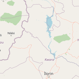
The Trois Rivières reserve lies within the Sudano-Sahelian transition zone of northern Benin, a landscape shaped by seasonal rainfall, long dry periods, and the gradual transition between wetter Sudanian woodland to the south and drier Sahelian formations to the north. The terrain is broadly flat to gently undulating, with shallow river valleys cut by the Sota, Tassiné, and Bouli rivers and their tributaries.
The natural vegetation of the reserve consists of a patchwork of tree savannas with scattered woody species, open shrubby savanna, gallery forests lining the watercourses, and patches of denser dry forest where soil moisture conditions allow. Together, these formations create a mosaic that contrasts sharply with the surrounding agricultural plains, where cropland, fallows, and villages dominate the visible landscape.
The hydrological landscape is central to the reserve's identity. By safeguarding the upper catchments of its three namesake rivers, the Trois Rivières forest influences water flow, sediment transport, and groundwater recharge across a catchment that extends well beyond the reserve's own boundaries. Over decades, however, the visible landscape has changed as woodland has been cleared for cultivation and grazing, leaving fragments of the original mosaic embedded in a much more human-modified setting.
Forêt classée des Trois Rivières ecosystems, habitats, and plant life
Ecologically, the Trois Rivières reserve sits at the interface between Sudanian and Sahelian biomes, where plant communities are adapted to a single pronounced rainy season and a long dry season. The vegetation is dominated by tree and shrub savannas, with woody species distributed in patterns that reflect soil depth, drainage, and the proximity of water. Along the rivers and seasonal streams, gallery forests form narrow but ecologically important corridors of denser, evergreen and semi-deciduous vegetation that stand in stark contrast to the surrounding open savanna.
The reserve's biodiversity value lies in this mosaic character. The combination of open woodland, shrubby savanna, gallery forest, and denser dry forest patches creates a variety of microhabitats, supporting different groups of plants, insects, birds, and mammals within a relatively compact area. The presence of gallery forest corridors is particularly important because these wooded strips maintain connectivity for wildlife movement and preserve humid conditions that allow more mesic plant species to persist in an otherwise dry environment.
Over the past several decades, however, the ecological character of the reserve has shifted as natural formations have given way to cultivated and fallow land. The loss of tree savanna, gallery forest, and dense dry forest cover has reduced the area of continuous natural habitat available to wildlife, while the spread of settlements and farmland has increased the proportion of human-dominated habitat. Despite this, patches of intact vegetation and the protected status of the reserve continue to anchor the ecological identity of the Trois Rivières landscape.
Forêt classée des Trois Rivières wildlife and species highlights
The Trois Rivières reserve has long been valued for its wildlife, alongside its watershed function, and is described as a wildlife reserve in addition to its classification as a forested protected area. Its mix of open savanna, gallery forest, and denser dry woodland historically supported populations of larger mammals typical of the West African Sudano-Sahelian belt.
Elephants are among the most emblematic species associated with the reserve. Reports from local media in 2020 described an elephant leaving the forest and approaching nearby villages, an occurrence that local residents treated with customary respect for wildlife. Such incidents highlight that, despite decades of habitat loss, the reserve and its surroundings still support large mammals, and that human settlements and wildlife habitat continue to overlap in this part of Benin.
Beyond elephants, the reserve's savanna and gallery forest habitats provide living space for a variety of mammals, birds, reptiles, and other animal groups characteristic of the transition between the Sudanian and Sahelian zones. The continued presence of such wildlife, even in reduced numbers, reflects the refuge function that protected status confers on a landscape that has otherwise been heavily transformed by agriculture, grazing, and settlement expansion.
Forêt classée des Trois Rivières conservation status and protection priorities
From a conservation perspective, the Trois Rivières reserve holds importance on several fronts. It is one of the older formally classified forests in Benin, designated in 1949 specifically to safeguard hydrological functions and to act as a barrier against desertification. The reserve's role in protecting the upper basins of the Sota, Tassiné, and Bouli rivers means that its conservation status directly affects water availability, soil stability, and downstream land use in a large part of northern Benin.
At the same time, the reserve is a striking example of the conservation challenges facing West African dryland forests. Documented studies show that between 1949 and 2016, a substantial share of its natural vegetation was lost to agriculture, fallow land, and settlements, with the rate of degradation accelerating after the late 1980s. The reserve has also experienced uncontrolled fires, often linked to hunting and poaching, and has suffered from illegal or poorly regulated timber extraction.
International attention to these dynamics is reflected in the World Bank's 2020 report on Benin's forests, which examined the Trois Rivières reserve alongside other classified forests and proposed policy instruments, projects, and supporting actions to slow degradation and promote more sustainable forest use. The reserve's ongoing legal protection, combined with this policy attention, gives it continued relevance as a conservation site even as its ecological condition has been reshaped by decades of competing pressures.
Forêt classée des Trois Rivières cultural meaning and human context
The Trois Rivières reserve is closely intertwined with the rural communities living along its borders. Forest resources have long played a central role in the local economy, providing fuelwood, charcoal, timber, honey, shea butter, and other non-timber products, as well as hunting grounds. For many households, the forest is also a source of agricultural land, and slash-and-burn shifting cultivation, together with transhumant cattle herding, has historically been among the most important livelihood strategies in the area.
This relationship has produced a long-standing tension between preservation objectives and the practical realities of subsistence in the Sudano-Sahelian zone. Surveys have identified a deep contradiction between the preservation laws governing the reserve and the daily practices of neighboring populations, who clear forest areas for farming and grazing to secure their survival. Local communities are generally familiar with wildlife, including large mammals such as elephants, and have developed customary ways of responding to animals moving out of the forest and into village areas, often framed around respect for and protection of wildlife.
The reserve also reflects broader dimensions of forest governance in Benin: questions of land tenure, the rights of local populations, the weaknesses of participatory forest management, and the budgetary constraints on forest administration have all shaped the trajectory of the Trois Rivières landscape. As such, the reserve is as much a cultural and social landscape, defined by the relationship between people and forest, as it is a strictly ecological one.
Top sights and standout views in Forêt classée des Trois Rivières
The Trois Rivières reserve stands out as one of the largest and oldest formally classified forests in northern Benin, with a designation dating back to 1949. Its defining feature is the protection of the upper basins of the Sota, Tassiné, and Bouli rivers, which gives the reserve both its name and its principal hydrological purpose. The protected area combines watershed protection with wildlife habitat conservation, a dual role that is increasingly rare in heavily cultivated dryland regions of West Africa.
Despite decades of agricultural expansion, the reserve still retains a mosaic of tree savanna, gallery forest, and denser dry woodland, along with a surviving presence of large mammals such as elephants that periodically emerge from the forest into nearby villages. It is also notable as a long-term case study in the pressures facing classified forests in francophone West Africa, and as a focal point for national and international discussions about balancing rural livelihoods, desertification control, and biodiversity protection in the Sudano-Sahelian belt.
Best time to visit Forêt classée des Trois Rivières
Northern Benin, including the Trois Rivières reserve area, follows a strongly seasonal climate with a single rainy season that typically runs from roughly May to October and a long dry season that occupies the rest of the year. The landscape is at its greenest and most photogenic during and shortly after the rains, when trees come into leaf, grasses grow tall, and water is more readily available in the rivers and seasonal streams. This is also typically the period when wildlife is easier to observe near water sources and along gallery forest corridors.
The dry season, by contrast, brings hazier conditions, leafless trees, and more concentrated wildlife activity around remaining water points, but it also coincides with the period of slash-and-burn land preparation, controlled burning, and seasonal transhumance movements, all of which can affect accessibility and the visibility of intact vegetation. For anyone interested in the natural landscape rather than agricultural cycles, the late rainy season and early post-rainy period offer the most favorable conditions for experiencing the reserve's savanna and gallery forest character in a relatively lush state.