

Mori Atlas logo
Wildlife reserveFortification Range Wilderness

A remote Great Basin wilderness defined by dramatic volcanic cliffs and forested ridgelines.

Fortification Range Wilderness: Volcanic Mountain Landscapes and Protected Geography in Eastern Nevada

Fortification Range Wilderness spans over 30,000 acres of protected volcanic terrain in eastern Nevada, offering a distinct study in Basin and Range topography. The landscape transitions from rolling pinyon-juniper highlands in the south to a rugged, cliff-dominated northern end that gives the mountain chain its fortified appearance. This wilderness protects a layered ecosystem ranging from dense woodlands to stands of ponderosa pine and aspen, providing an undeveloped, tranquil setting for observing Great Basin natural history.

wilderness areavolcanic landscapeGreat Basinmountain rangeLincoln County Nevadapinyon-juniper woodland

Fortification Range Wilderness

Wildlife reserve

Park overview

Structured park overview, official facts, and landscape profile for Fortification Range Wilderness

Fortification Range Wilderness park facts, protected area profile, and essential visitor context

Review the core facts for Fortification Range Wilderness, including designation, size, terrain, visitor scale, habitats, and operating context in one park-focused overview.

About Fortification Range Wilderness

Fortification Range Wilderness occupies a remote stretch of eastern Nevada, well off the state's main travel corridors and close to the Utah state line. Although it sits in a region better known for wide-open basins and scattered ranching country, the wilderness is defined by the Fortification Range itself: a long, narrow spine of volcanic mountains that rises above the surrounding desert flats and sagebrush steppe.

The range is unusually long in proportion to its width, stretching roughly 13.5 miles across the wilderness in a roughly north-south orientation. Despite the name's suggestive fortifications, most of the range is composed of relatively gentle ridges and rounded uplands, where pinyon and juniper woodland covers the slopes in a thick, continuous cloak. Toward the north end, however, the character of the mountains changes abruptly; the terrain becomes far more rugged, with steep cliff faces, rock outcrops, and dramatic exposures of volcanic rock that visually anchor the wilderness and give it its most distinctive scenery.

Because the area is administered by the Bureau of Land Management rather than the National Park Service, the visitor experience here is oriented toward self-reliant, low-impact recreation. There are no developed visitor centers or major facilities inside the wilderness, and access is via rough backcountry routes. The result is a quiet, lightly visited landscape, valued primarily for its natural condition, its geological story, and the unbroken sweep of volcanic terrain it preserves. It is the kind of wilderness that rewards visitors prepared for real solitude and a strong sense of Basin and Range geography.

Quick facts and research context for Fortification Range Wilderness

Fortification Range Wilderness is a U.S. federal wilderness area located entirely within Lincoln County, Nevada, in the eastern part of the state near the Utah border. Designated in 2004, the wilderness is managed by the Bureau of Land Management under the U.S. Department of the Interior. The nearest community of any size is the small town of Lund, with the larger town of Ely lying roughly 50 miles to the northwest.

The protected area covers just over 30,000 acres and is built around the Fortification Range, a 13.5-mile-long volcanic mountain system that anchors the wilderness. The area is classified as IUCN Category Ib, recognizing its character as a wilderness managed primarily for the preservation of its natural conditions and limited, low-impact recreation.

Protection and recognition

Explore terrestrial protection metrics and management scope records for Fortification Range Wilderness.

Fortification Range Wilderness Protection Status and Recognition Data

Terrestrial protection status records outline the management framework established for Fortification Range Wilderness. Official documentation details the scope of conservation boundaries without referencing external international recognition sources.

Protection details

Protection scope
Terrestrial
Transboundary protection
No
Park context

Deeper park guide and search-rich context for Fortification Range Wilderness

Fortification Range Wilderness history, landscape, wildlife, and travel context

Explore Fortification Range Wilderness through its history, landscape character, ecosystems, wildlife, conservation priorities, cultural context, and seasonal travel timing in a structured park guide built for atlas discovery and search intent.

Why Fortification Range Wilderness stands out

Fortification Range Wilderness is best known for protecting the full length of the Fortification Range, a long volcanic mountain chain whose sheer cliffs and massive rock outcrops give the range its fortified, wall-like appearance. The dramatic contrast between the range's gentle, rolling southern ridges and its rugged, precipitous northern end is one of its defining visual features. It is also recognized as a representative example of an eastern Great Basin wilderness, combining classic pinyon-juniper woodland with ponderosa pine, aspen, and cottonwood stands in its higher and more sheltered northern reaches. Together with its remoteness and largely undeveloped character, this mix of volcanic terrain and Great Basin vegetation defines the wilderness's identity.
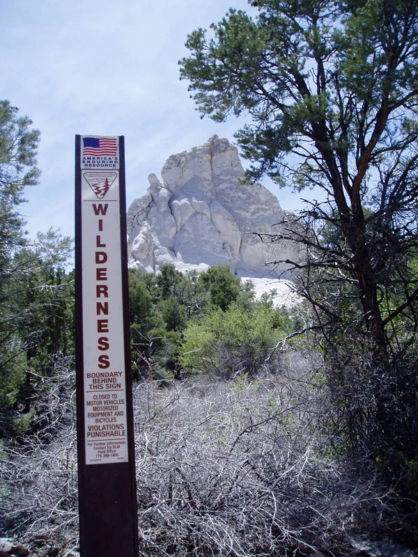
A tall, vertical, brown sign marked Wilderness stands in the foreground, with trees and a prominent light-colored volcanic rock formation in the background.
A wilderness boundary sign marks the entrance to the Fortification Range Wilderness in Nevada.

Fortification Range Wilderness history and protected-area timeline

Fortification Range Wilderness has a comparatively recent formal protection history. The area was designated as a federally recognized wilderness in 2004, becoming one of a generation of new wilderness areas added to the National Wilderness Preservation System through the work of the U.S. Congress and the Bureau of Land Management.

Because the Fortification Range sits in an arid, sparsely populated part of Nevada, the surrounding landscape has historically experienced limited industrial development, and the mountains themselves have never been heavily settled. The land has long been managed by the federal government as part of the broader public domain. Wilderness designation in 2004 formally committed this landscape to long-term preservation in its natural condition, placing it under the stricter use rules that govern U.S. wilderness areas and restricting most forms of development and mechanized travel.

Since its designation, the wilderness has remained under Bureau of Land Management administration, and there is no indication of significant post-designation changes in land status. The protected area is now nationally recognized as a component of the U.S. wilderness system and continues to be managed for wilderness character, primitive recreation, and ecological preservation.

Fortification Range Wilderness landscape and geographic character

The landscape of Fortification Range Wilderness is dominated by the Fortification Range, a long volcanic mountain chain that rises sharply above the lower desert basins around it. The range runs roughly 13.5 miles through the wilderness and represents one of the cleanest expressions of Basin and Range topography in this part of Nevada, with a single, well-defined mountain block standing above broad, gently sloping valley floors.

Geologically, the Fortification Range is built almost entirely of volcanic materials, a legacy of the intense volcanic activity that shaped much of the broader region during the geologic past. The result is a mountain landscape defined by volcanic rock, with a varied topography that shifts noticeably along the length of the range. Across most of its extent, the mountains form smooth, rounded ridges and broad uplands; the slopes are typically gentle, vegetation cover is dense, and the land reads as a continuous wooded highland rather than craggy peaks.

At the northern end of the range, the landscape becomes much more dramatic. Here, the volcanic terrain rises into steep, precipitous slopes, with sheer cliffs and large, exposed rock outcrops that give the range its wall-like, fortified appearance. These northern cliffs are the visual centerpiece of the wilderness and the most recognizable feature of the Fortification Range, contrasting strongly with the softer southern ridges and reinforcing the wilderness's sense of geological variety within a relatively small area.

Fortification Range Wilderness ecosystems, habitats, and plant life

Ecologically, Fortification Range Wilderness sits at a transition zone where Great Basin vegetation patterns meet influences from the Colorado Plateau and the higher mountain systems to the north and west. The result is a diverse vegetation mosaic for such a compact area, ranging from low, dense woodland on arid slopes to cooler, moister forest types in sheltered canyons and at higher elevations.

The southern portion of the wilderness is dominated by pinyon-juniper woodland, one of the most characteristic vegetation communities of the interior American West. In this part of the range, pinyon pine and juniper form a nearly continuous canopy across the slopes, creating a dense, low forest that supports wildlife adapted to dry woodland conditions. The understory here is sparse, and the visual landscape is one of uniformly textured, dark green ridges broken only by occasional rock outcrops.

The northern end of the wilderness supports a richer and more varied mix of trees. Ponderosa pine appears alongside pinyon and juniper, while aspen and cottonwood grow in cooler, wetter sites where elevation, drainage, or canyon shading provide favorable conditions. This northern woodland is more open and structurally diverse, with a mix of conifers and broadleaf trees that supports a broader range of habitat niches and contributes to the wilderness's overall ecological diversity.

Fortification Range Wilderness wildlife and species highlights

The wildlife of Fortification Range Wilderness reflects the typical mix of species found across the eastern Great Basin and the forested ranges of interior Nevada. The combination of dense pinyon-juniper woodland, scattered ponderosa pine forests, aspen stands, and adjacent open basins supports both woodland and open-country species.

Mule deer are among the most widespread and visible large mammals, moving through the woodlands and along the ridgetops where cover is plentiful. Antelope, also known as pronghorn, are present in the wilderness as well, particularly where woodland gives way to more open ground at the edges of the range. These two ungulates form the core of the wilderness's large herbivore community and are central to the area's ecological identity.

Predators, including the mountain lion, roam the range, taking advantage of the cliffs, dense cover, and abundant deer populations. Raptors are also a regular presence in the wilderness, using the cliffs at the northern end of the range and the open airspace above the ridges for hunting. Smaller mammals, songbirds, and reptiles typical of Great Basin woodland and steppe habitats round out the broader wildlife community, although the steep, broken terrain and dense cover mean that much of the wildlife here tends to be seen only by visitors willing to spend extended time quietly in the backcountry.

Fortification Range Wilderness conservation status and protection priorities

Fortification Range Wilderness is a meaningful conservation unit because it preserves an entire volcanic mountain range in a largely undisturbed state within a region where human pressure on the land has historically been relatively low but not absent. Wilderness designation locks in legal protection for the area, limiting any future road construction, mineral development, or mechanized use that could fragment or degrade its natural character.

Ecologically, the wilderness is valuable because it protects the full environmental gradient of the Fortification Range, from the dense pinyon-juniper slopes of the south to the ponderosa pine and aspen communities of the north, along with the cliff and outcrop habitats at the range's northern end. This concentration of varied woodland and cliff habitat within a relatively small, contiguous area gives the wilderness an outsized role in maintaining regional habitat connectivity and ecological representation in the eastern Great Basin.

The wilderness also contributes to conservation at a national scale as part of the National Wilderness Preservation System, one of the strongest legal frameworks for land preservation in the United States. Its IUCN Category Ib classification reflects a management approach centered on protecting wilderness character and ecological processes rather than on developing facilities or accommodating heavy visitor use, and this designation helps ensure that the Fortification Range's landscapes and wildlife habitats remain intact for the long term.

Top sights and standout views in Fortification Range Wilderness

The strongest single highlight of Fortification Range Wilderness is the contrast within the Fortification Range itself. Across most of its length, the wilderness feels like a long, gentle forested mountain, dominated by dense pinyon-juniper woodland and rounded ridges; in the north, the range suddenly becomes steep and dramatic, with sheer cliffs and massive volcanic outcrops that give the wilderness its most striking scenery and its name.

The wilderness also stands out for the diversity of woodland communities packed into a compact area. Ponderosa pine, pinyon pine, juniper, aspen, and cottonwood all appear within the protected landscape, with the more drought-adapted species concentrated in the south and the cooler, moisture-loving species in the north. Combined with the presence of mule deer, antelope, mountain lions, and raptors, this gives the wilderness a layered natural character that contrasts with many of the more uniform Basin and Range landscapes that surround it.

Best time to visit Fortification Range Wilderness

The character of a visit to Fortification Range Wilderness changes meaningfully with the seasons, in large part because the range sits at a relatively high elevation in the eastern Great Basin where winters can be cold and snowy. Late spring through early fall is generally the most forgiving window for travelers, when temperatures are warmer, high-elevation roads are more likely to be passable, and the vegetation is in active growth, making wildlife viewing and photography more productive.

Spring can be a particularly rewarding time for wildflower displays and active wildlife, while summer brings longer days and more reliable conditions for backpacking and horseback riding across the range. Fall tends to be quiet, with cooler nights and changing light across the forested ridges. Winter is the most demanding season, with snow likely at higher elevations and limited access, though it also delivers the greatest solitude for visitors equipped for severe winter conditions. The specific timing of any visit is best shaped by current weather and road conditions rather than by fixed calendar dates.

Monthly climate preview

Long term representative measurements tracking annual temperature and precipitation rhythm

Fortification Range Wilderness Climate Normals, Average Temperature and Precipitation

Representative coordinates record measured monthly temperature and precipitation values across a standard thirty year climatology period. Detailed twelve month breakdowns provide complete meteorological context for understanding regional climate patterns.
Annual mean9 °C
-2 °C23 °C
Jan-2°
Feb
Mar
Apr
May13°
Jun19°
Jul23°
Aug22°
Sep17°
Oct
Nov
Dec-2°
Warmest month
July

23.2 °C

Coolest month
December

-2.3 °C

Wettest month
February

1 mm/day

Driest month
June

0.5 mm/day

Park location guide

Geography guide, regional context, and park location map for Fortification Range Wilderness

Fortification Range Wilderness park geography, regions, and map view in United States of America

Understand where Fortification Range Wilderness sits in United States of America through a broader geographic reading of the surrounding landscape, nearby location context, and its mapped position within the national park landscape.

How Fortification Range Wilderness fits into United States of America

The United States of America is a federal presidential republic and one of the world's largest countries by area and population. It consists of 50 states across a vast territory spanning multiple time zones, with its capital in Washington, D.C. and largest city in New York City. The nation has a diverse economy, influential political system, and significant cultural and military presence globally.

Wider geography shaping Fortification Range Wilderness in United States of America

The United States occupies a vast territory in North America, bordered by Canada to the north and Mexico to the south. The 48 contiguous states stretch from the Atlantic to the Pacific Ocean, while Alaska occupies the northwestern region and Hawaii is an archipelago in the Pacific. The country encompasses diverse terrain including the Rocky Mountains, Appalachian Mountains, Great Plains, and extensive river systems.

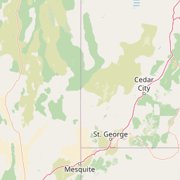
Map view of Fortification Range Wilderness

Use this park location map to pinpoint Fortification Range Wilderness in United States of America, understand its exact geographic position, and read its mapped placement within the surrounding landscape more clearly.

Pigeon | © OpenStreetMap contributors

Location context for Fortification Range Wilderness

Nevada

Visualizing the dramatic cliffs, rolling ridges, and woodland habitats of the eastern Great Basin

Fortification Range Wilderness Photos and Volcanic Mountain Landscapes

Visual documentation captures the stark contrast between gentle southern pinyon-juniper woodlands and sheer northern volcanic cliffs across the protected terrain. Examining these photographs helps researchers and visitors understand the distinctive geology and remote habitat character of the mountain range.

A tall, vertical, brown sign marked Wilderness stands in the foreground, with trees and a prominent light-colored volcanic rock formation in the background.

Park atlas

Compare regional mountain ranges, volcanic terrain, and connected Great Basin habitats.

Explore Parks Near Fortification Range Wilderness and Surrounding Protected Landscapes

Continue browsing other protected areas near Fortification Range Wilderness to examine similar volcanic terrain and remote mountain ranges across the region. Comparing adjacent wildlands provides deeper context for the unique geological formations and woodland ecosystems of the eastern Great Basin.
Wildlife reserveNevada
About 30 km away#1 closest

Northwest

Mount Grafton Wilderness: Protected Mountain Geography and Forested Landscapes in Nevada

High-elevation wilderness within the Schell Creek Range.

Mount Grafton Wilderness offers a deep dive into the high-desert mountain geography of eastern Nevada. This protected area features a striking 10,990-foot peak and a wide range of forest types, including rare bristlecone pine stands. The region provides a critical look at the complex topography and ecological structure of the Schell Creek Range for those researching protected land boundaries and Great Basin habitats.

Area
318.71 km²
Established
2006
IUCN
Ib
Relief
Mountain
National parkNevada
About 32 km away#2 closest

North

Great Basin National Park: Nevada's Protected National Park Geography and Map Details

Understanding its mapped boundaries and regional context.

Delve into the protected landscape of Great Basin National Park, a significant national park located in Nevada. This entry focuses on the park's geographic attributes, providing users with essential map context, details on its protected area boundaries, and an understanding of its place within the broader regional geography. It serves as a focused resource for exploring the park's unique natural terrain and landscape characteristics through an atlas-driven lens.

Area
312.3 km²
Established
1986
IUCN
II
Visitors
144.9K annual
A watercolor painting showing soft green hills, distant pink-hued mountains, and a pale blue lake in a serene, stylized landscape.
Protected landscapeNevada
About 53 km away#3 closest

West

Humboldt, Toiyabe National Forest: Protected Landscape and Regional Mountain Geography

A vast network of Nevada mountain ranges and alpine wilderness

Humboldt, Toiyabe National Forest serves as a defining public land entity across Nevada and eastern California. As the largest national forest in the contiguous United States, it preserves a striking collection of isolated mountain ranges, including the Ruby Mountains and the rugged Jarbidge wilderness, within a broader basin-and-range landscape. Examine the boundaries and terrain that characterize this complex, high-desert ecosystem.

Area
25,454 km²
Established
1908
Relief
Mountain
Access
Easy access
Protected areaNevada
About 82 km away#4 closest

North

Mount Moriah Wilderness: A Geographic Profile of the Northern Snake Range Protected Area

High elevation limestone terrain in eastern Nevada

The Mount Moriah Wilderness represents a significant protected area in eastern Nevada, anchored by the iconic 12,050-foot Mount Moriah and the expansive flat-topped Table plateau. This rugged high-country landscape displays deep limestone exposures, shallow caves, and a rich array of riparian habitats. Spanning an entire elevational gradient of the Great Basin, the wilderness preserves ancient bristlecone pine groves alongside critical archaeological sites that document long-term human use of these mountains.

Area
363.4 km²
Established
1989
Relief
Mountain
Water
Minor water
Wildlife reserveNevada
About 86 km away#5 closest

Northwest

Red Mountain Wilderness: Mapping Protected Volcanic Terrain in Eastern Nevada

High-desert wilderness, ancient pines, and volcanic geography.

Red Mountain Wilderness encompasses a rugged block of protected high-country featuring dramatic, iron-rich volcanic slopes. This arid landscape stands out in the White Pine Range for its deep red coloration and the presence of long-lived bristlecone pine. Analyze the boundaries and geographic context of this significant Great Basin wilderness through our structured atlas and map resources.

Area
82.9 km²
Established
2006
IUCN
Ib
Relief
Mountain
Wildlife reserveNye County
About 106 km away#6 closest

Southwest

Quinn Canyon Wilderness: Exploring Protected Mountain Geography in Central Nevada

High-desert ridges and alpine canyon ecosystems

Quinn Canyon Wilderness serves as a vital protected area for understanding Great Basin geography. Its landscape of deep, V-shaped canyons and high ridgelines supports unique biological gradients from pinyon-juniper forests to rare bristlecone pine, providing a study in extreme solitude and rugged mountain terrain.

Area
106.25 km²
Established
1989
IUCN
Ib
Relief
Mountain
Wildlife reserveUtah
About 155 km away#7 closest

Southeast

Red Mountain Wilderness: Mapped Sandstone Massif and Protected Landscape in Utah

Ecological transitions between the Mojave Desert and Great Basin

Red Mountain Wilderness is a distinct protected landscape in southwestern Utah characterized by its dramatic Navajo sandstone block. Positioned near the Gunlock Fault and Snow Canyon, the area features rugged desert terrain where Mojave and Great Basin ecosystems converge. This wilderness preserves significant archaeological history and diverse plant communities within its sandstone canyons and flats, offering a window into the varied natural environment of the region.

Area
75.8 km²
Established
2009
IUCN
Ib
Relief
Upland
National parkUtah
About 161 km away#8 closest

Southeast

Zion National Park National Park: Detailed Mapped Geography and Protected Landscape Identity

Explore the mapped terrain and regional context of this Utah national park.

Zion National Park represents a key protected area within Utah, ideal for detailed geographic exploration. This canonical page offers insights into the park's specific mapped boundaries, its inherent landscape character, and its regional geographic setting. It is designed for users seeking to understand the atlas-level significance of Zion National Park as a national park entity, focusing on its protected terrain and natural geography.

Area
593.26 km²
Established
1919
IUCN
II
Visitors
4.9M annual

Common questions about visiting, size, designation, and location context for Fortification Range Wilderness

Fortification Range Wilderness FAQs for park facts, access, geography, and protected area context

Find quick answers about Fortification Range Wilderness, including protected-area facts, park geography, trail and visitor context, and how the park fits into its surrounding country and regional landscape.
MoriAtlas Explorer

Continue Your Protected Areas Search Across the Global Atlas

Deepen your exploration by continuing the structured search for national parks and protected areas worldwide. Utilize the comprehensive filtering capabilities to compare different conservation landscapes and refine your understanding of global park geography. Discover more about the distribution and characteristics of protected natural areas.

Global natural geography