
Mori Atlas logo
Nature reserveGamble Creek Ecological Reserve

A strict nature reserve focused on scientific research across coastal hem-lock and subalpine biogeoclimatic zones.

Gamble Creek Ecological Reserve: Mapping the Protected Forest and Bog Landscapes of British Columbia

Gamble Creek Ecological Reserve protects 1,026 hectares of representative north-coastal terrain in British Columbia, Canada. The reserve spans an altitudinal gradient from sea level to 900 metres, encompassing both the Hypermaritime Coastal Western Hemlock and the Mountain Hemlock biogeoclimatic zones. This high-integrity scientific site preserves extensive moss-laden forest and wetland bog complexes essential for longitudinal ecological research.

ecological reservecoastal forestboreal wetlandsbogsmoss-rich foresttemperate rainforest
An artistic, flat-style vector illustration depicting a valley with a winding river, a distant waterfall, and pine trees in the foreground and midground.

Gamble Creek Ecological Reserve

Nature reserve

Park overview

Structured park overview, official facts, and landscape profile for Gamble Creek Ecological Reserve

Gamble Creek Ecological Reserve park facts, protected area profile, and essential visitor context

Review the core facts for Gamble Creek Ecological Reserve, including designation, size, terrain, visitor scale, habitats, and operating context in one park-focused overview.

About Gamble Creek Ecological Reserve

Gamble Creek Ecological Reserve is a protected natural area on the remote North Coast of British Columbia, Canada, dedicated to maintaining ecological integrity and supporting scientific research. Established in 1991 and managed by BC Parks, the reserve encompasses a transect of terrain rising from sea level toward the interior hills, providing a compressed cross-section of the environmental gradients that shape the region's forests and peatlands. The McNeil River runs through or adjacent to this landscape, framing the lowland portion of the reserve with riparian influence.

The protected area is situated within the asserted traditional territory of the Tsimshian First Nations, reflecting the deep and continuing human relationship with this stretch of the North Coast. Administratively, it falls within the North Coast Regional District and is formally recognized as an ecological reserve under British Columbia's Ecological Reserves Act, a designation reserved for sites of high scientific and ecological importance.

A defining characteristic of Gamble Creek is its ecological zonation. The reserve covers both the Hypermaritime Coastal Western Hemlock zone at lower elevations and the Mountain Hemlock zone higher up, capturing the transition from wind-dominated, wet coastal forests to cooler, more montane-influenced stands. This overlap of biogeoclimatic zones, combined with extensive bog and peatland systems, makes the reserve especially valuable for ecosystem classification, long-term vegetation monitoring, and studies of boreal-to-coastal forest dynamics.

Although the area is not oriented toward recreation, its environmental significance is substantial. The continuous forest cover, intact bog complexes, and altitudinal gradient together offer a rare, undisturbed benchmark for understanding how British Columbia's north coast forests function and respond to environmental change.

Quick facts and research context for Gamble Creek Ecological Reserve

Gamble Creek Ecological Reserve is a Class Ia strict nature reserve managed by BC Parks and established in 1991 under the Ecological Reserves Act of British Columbia. It protects 1,026 hectares of north-coastal landscape in the North Coast Regional District, spanning elevations from near sea level to about 900 metres. The reserve safeguards forest and bog vegetation across both the Hypermaritime Coastal Western Hemlock and Mountain Hemlock biogeoclimatic zones, and serves as a long-term reference site for ecosystem classification research on British Columbia's Pacific coast.

Protection and recognition

Explore documented terrestrial protection scopes and official conservation frameworks.

Gamble Creek Ecological Reserve Protection Status and Governance Records

Gamble Creek Ecological Reserve maintains documented terrestrial protection statuses and designated conservation frameworks. Structured records compile available management parameters and international recognition metrics for the protected landscape.

Protection details

Protection scope
Terrestrial
Park context

Deeper park guide and search-rich context for Gamble Creek Ecological Reserve

Gamble Creek Ecological Reserve history, landscape, wildlife, and travel context

Explore Gamble Creek Ecological Reserve through its history, landscape character, ecosystems, wildlife, conservation priorities, cultural context, and seasonal travel timing in a structured park guide built for atlas discovery and search intent.

Why Gamble Creek Ecological Reserve stands out

The reserve is best known for its research-focused protection of north-coastal forest and bog complexes in British Columbia. Its exceptional value lies in spanning the transition between Hypermaritime Coastal Western Hemlock and Mountain Hemlock biogeoclimatic zones, which allows scientists to study how coastal forest ecosystems, bog vegetation, and tree species composition shift from lowland to mid-elevation settings along the North Coast. Gamble Creek is also recognized for preserving characteristic plant communities of the wet coastal region, including Labrador tea, cranberry, lingonberry, cloudberry, mountain heathers, sphagnum moss, and a suite of bog-adapted species such as sundew, deergrass, and beak-rush. Together, these features make the reserve an important natural reference point for understanding Pacific north-coast forest ecology.
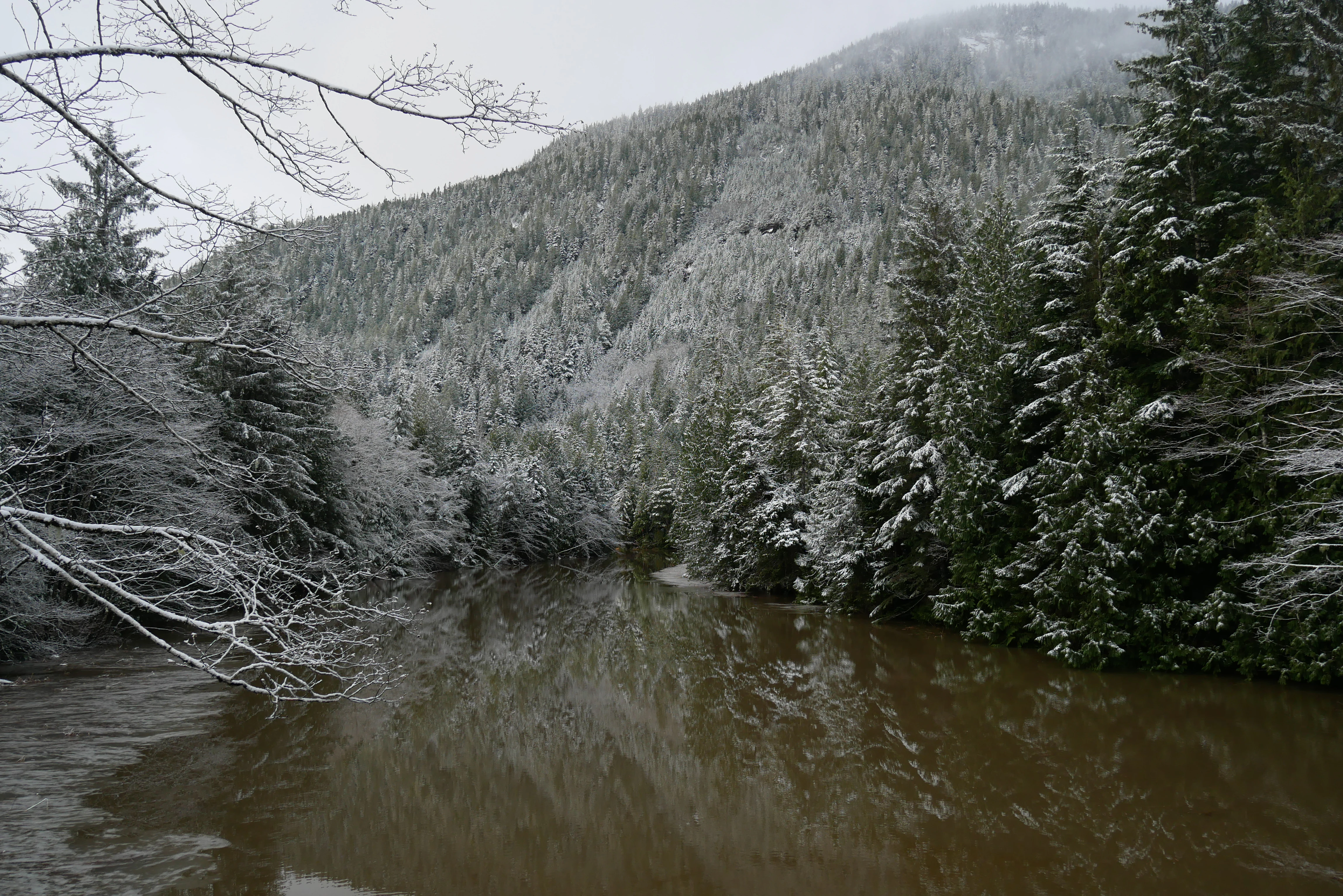
A calm, brown-tinted river winds through a dense, snow-covered coniferous forest with a steep forested mountain slope in the background.
A view of the McNeil River flowing through the snow-dusted forest landscape of Gamble Creek Ecological Reserve.

Gamble Creek Ecological Reserve history and protected-area timeline

Gamble Creek Ecological Reserve was established in 1991 under the Ecological Reserves Act of British Columbia, a provincial framework designed to set aside areas of significant scientific and educational value. The reserve was created specifically to facilitate scientific research on tree species and to support ecosystem classification work for north-coastal forest stands and bog vegetation.

Its selection was tied to the recognition that the site spans multiple biogeoclimatic zones and contains representative examples of lowland and mid-elevation coastal ecosystems that were becoming increasingly rare in an unchanged state. By protecting this transect, British Columbia ensured a long-term reference area for research into how coastal forests and bogs develop across elevation, climate, and moisture gradients.

Since establishment, the reserve has remained under the management of BC Parks and has continued to serve its original purpose: providing a relatively undisturbed natural setting in which ecologists, botanists, and forest scientists can study vegetation patterns, succession, and ecological classification in one of the wettest and most biologically distinctive forested regions of Canada.

The area also sits within the asserted traditional territory of the Tsimshian First Nations, anchoring the protected landscape within a long history of Indigenous presence and stewardship along the North Coast.

Gamble Creek Ecological Reserve landscape and geographic character

The landscape of Gamble Creek Ecological Reserve is shaped by the wet, temperate climate of British Columbia's North Coast and by a substantial altitudinal gradient in a relatively compact area. Elevations within the reserve extend from near sea level to roughly 900 metres, producing visible shifts from low-elevation coastal conditions to cooler, higher-elevation settings that approach subalpine character.

At lower elevations, the terrain is dominated by dense, moist coniferous forest typical of the Hypermaritime Coastal Western Hemlock zone, while higher elevations grade into the cooler, shorter-statured forests of the Mountain Hemlock zone. Between these forested zones, the reserve contains open and partially forested bog systems, where saturated soils support a distinct peatland plant community. Streams and rivulets, including the McNeil River corridor, cut through the landscape and contribute to the wet, moss-rich environment that defines the area.

The combined effect is a layered coastal landscape of forest canopy, bog openings, riparian margins, and montane transition, all bound together by the persistent moisture and fog-influenced climate of the North Coast.

Gamble Creek Ecological Reserve ecosystems, habitats, and plant life

Gamble Creek Ecological Reserve preserves a representative range of ecosystems from a region where forest and bog communities are deeply intertwined. Its two principal biogeoclimatic zones, the Hypermaritime Coastal Western Hemlock zone and the Mountain Hemlock zone, contain overlapping but distinct forest types. The lower-elevation Hypermaritime zone features tall, structurally complex coniferous forest, while the Mountain Hemlock zone above supports shorter, often more open stands adapted to harsher montane conditions.

Bog vegetation is a major ecological feature of the reserve. Sphagnum moss forms much of the ground layer across many of these sites, and characteristic bog species such as deergrass, beak-rush, deer-cabbage, sundew, and gentiana inhabit the wetter, nutrient-poor peatland environments. These peatland complexes are ecologically significant for carbon storage, hydrological regulation, and as habitat for specialized plant species.

The reserve's intact forest cover, undisturbed bog communities, and altitudinal gradient make it a valuable benchmark for understanding the structure, composition, and ecological processes of north-coastal British Columbia ecosystems.

Gamble Creek Ecological Reserve wildlife and species highlights

The wildlife profile of Gamble Creek Ecological Reserve is consistent with the broader character of British Columbia's North Coast, where coastal temperate rainforest and bog complexes support species adapted to persistent moisture, dense coniferous cover, and peatland environments. The reserve is not primarily managed or advertised as a wildlife viewing destination, and detailed species inventories are not extensively documented in public sources.

The ecological integrity of the reserve, combined with its intact forest and bog habitats, suggests habitat value for typical north-coast fauna including small mammals, migratory and resident birds associated with coniferous forest and wetland margins, and other species characteristic of Hypermaritime and Mountain Hemlock environments.

Gamble Creek Ecological Reserve conservation status and protection priorities

Gamble Creek Ecological Reserve holds meaningful conservation value as an IUCN Category Ia strict nature reserve, the highest level of protection focused on preserving ecological processes and scientific reference sites. Its protected status under British Columbia's Ecological Reserves Act indicates that the area has been formally recognized for its ecological and scientific importance, and management prioritizes minimal disturbance and long-term ecological integrity.

The reserve's significance increases because it spans two biogeoclimatic zones and includes substantial bog and forest complexes in a region where such undisturbed transects are increasingly rare. By maintaining a continuous gradient from coastal lowland to upper-elevation forest, the reserve provides a long-term reference point for monitoring how north-coast ecosystems function, how vegetation communities respond to change, and how different biogeoclimatic zones interface along the North Coast.

In this way, Gamble Creek contributes not only to local habitat protection, but also to the broader scientific infrastructure needed to understand and conserve the temperate rainforests and peatland systems of British Columbia's coast.

Gamble Creek Ecological Reserve cultural meaning and human context

The reserve lies within the asserted traditional territory of the Tsimshian First Nations, whose deep historical, cultural, and subsistence connections to the North Coast predate the establishment of the ecological reserve by many centuries. This positioning acknowledges the area as part of a long-standing Indigenous landscape shaped by seasonal use, knowledge, and relationship with coastal rivers, forests, and marine-freshwater interfaces. The reserve's modern protection framework overlays, rather than replaces, the enduring cultural presence and territorial significance of the Tsimshian within this region.

Top sights and standout views in Gamble Creek Ecological Reserve

Gamble Creek Ecological Reserve is distinguished by its altitudinal gradient spanning the Hypermaritime Coastal Western Hemlock and Mountain Hemlock biogeoclimatic zones, allowing direct comparison of forest types within a single protected area. It preserves some of the most representative bog complexes of British Columbia's North Coast, including sphagnum-dominated peatlands with typical species such as sundew, deergrass, beak-rush, and deer-cabbage.

Its establishment in 1991 under the Ecological Reserves Act gives it formal scientific importance, while its IUCN Category Ia strict nature reserve designation reflects an emphasis on ecological integrity over recreation. The combination of coastal forest, montane transition, and bog systems in a relatively compact 1,026-hectare protected landscape makes Gamble Creek a significant natural laboratory for north-coastal ecological research.

Best time to visit Gamble Creek Ecological Reserve

Gamble Creek Ecological Reserve is managed primarily for scientific research and ecological protection rather than recreation, so visits are generally oriented toward research or limited educational purposes. The reserve's wet, moss-laden coastal forests and bog systems are most characteristic and biologically active during the warmer months, when snow has receded from lower elevations and field research on vegetation and classification is most feasible. Winter brings heavy precipitation, snow at higher elevations, and accessibility constraints typical of the North Coast, making the late spring through early fall period the most practical window for any research or authorized activity, though visitors should always observe the conditions set by BC Parks.
Monthly climate preview

Monthly temperature ranges and precipitation averages from NASA data records

Gamble Creek Ecological Reserve Climate Normals and Annual Weather Patterns

Gamble Creek Ecological Reserve records long term temperature and precipitation shifts across representative coordinate sampling points throughout the year. Reviewing the complete monthly climate profile reveals precise weather variations and historical baseline averages.
Annual mean5 °C
-1 °C13 °C
Jan-1°
Feb-1°
Mar
Apr
May
Jun11°
Jul13°
Aug13°
Sep11°
Oct
Nov
Dec-1°
Warmest month
August

13.2 °C

Coolest month
January

-1.3 °C

Wettest month
November

10.7 mm/day

Driest month
May

4.4 mm/day

Park location guide

Geography guide, regional context, and park location map for Gamble Creek Ecological Reserve

Gamble Creek Ecological Reserve park geography, regions, and map view in Canada

Understand where Gamble Creek Ecological Reserve sits in Canada through a broader geographic reading of the surrounding landscape, nearby location context, and its mapped position within the national park landscape.

How Gamble Creek Ecological Reserve fits into Canada

Canada is a federal parliamentary constitutional monarchy spanning North America from the Atlantic to the Pacific and Arctic Oceans. With a population of over 41 million, it is officially bilingual in English and French at the federal level. The country gained independence from the United Kingdom through a gradual process culminating in 1982.

Wider geography shaping Gamble Creek Ecological Reserve in Canada

Canada occupies the northern portion of North America, sharing its longest international border with the United States. The country extends from the Atlantic Ocean to the Pacific Ocean and northward into the Arctic Ocean, giving it the longest coastline of any nation.

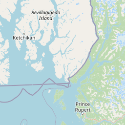
Map view of Gamble Creek Ecological Reserve

Use this park location map to pinpoint Gamble Creek Ecological Reserve in Canada, understand its exact geographic position, and read its mapped placement within the surrounding landscape more clearly.

Pigeon | © OpenStreetMap contributors

Location context for Gamble Creek Ecological Reserve

British Columbia

Visual reference of coastal forests, bog complexes, and altitudinal terrain

Gamble Creek Ecological Reserve Photos, Scenery, and Protected Landscapes

Visual documentation captures the diverse terrain, moss-rich forests, and open peatland complexes of Gamble Creek Ecological Reserve. Exploring these protected area views reveals the shifting plant communities and wet coastal environments spanning the North Coast region.

A calm, brown-tinted river winds through a dense, snow-covered coniferous forest with a steep forested mountain slope in the background.

Park atlas

Compare adjacent coastal forests, peatland reserves, and regional North Coast terrain.

Explore Parks Near Gamble Creek Ecological Reserve and Surrounding Protected Areas

Browsing other parks near Gamble Creek Ecological Reserve reveals a wider network of protected landscapes across the North Coast. Comparing these nearby reserves provides valuable geographic context for understanding regional forest bog complexes and coastal ecosystems.
A watercolor painting showing a lake, a forested shoreline, and distant mountains in a soft palette.
State or regional parkBritish Columbia
About 9.6 km away#1 closest

West

Diana Lake Provincial Park: Mapping Coastal Rainforest and Wetland Geography in British Columbia

An examination of North Coast forest and freshwater ecosystems

Diana Lake Provincial Park represents a significant protected area in British Columbia, showcasing the diverse ecological character of the North Coast. The park boundary encompasses a mosaic of old-growth rainforest, open blanket bogs, and freshwater aquatic systems. By protecting these varied terrains, the region maintains vital habitats for Pacific salmon species while providing a structured landscape for understanding the wet maritime environment of the Pacific Northwest.

Area
2.33 km²
Established
1980
IUCN
II
Relief
Upland
Watercolor painting of a coastal scene with green islands, coniferous trees, and soft, hazy mountains in the background, set against a white background.
Marine protected areaBritish Columbia
About 20 km away#2 closest

West

Kitson Island Marine Provincial Park Map and Coastal Protected Area Atlas

Protected island and estuarine landscape in British Columbia

Kitson Island Marine Provincial Park encompasses a vital coastal island and the adjacent Flora Bank at the mouth of the Skeena River. This protected marine environment provides a rare example of accessible sandy beach terrain on the North Coast. Use this atlas resource to understand the park boundaries, island geography, and estuarine interface within the broader Inside Passage conservation network.

Area
0.45 km²
Established
1993
IUCN
II
Relief
Lowland
A soft watercolor illustration depicting a calm river scene with evergreen trees, a grassy riverbank, and distant rolling hills in pale green and pink tones.
State or regional parkBritish Columbia
About 49 km away#3 closest

East

Exchamsiks River Provincial Park: Protected Old-Growth Forest Geography in British Columbia

A rare maritime Sitka spruce landscape in the Skeena River estuary

Situated at the meeting of the Exchamsiks and Skeena rivers, this provincial park protects a significant stand of unlogged old-growth coastal rainforest. The terrain provides a compact, ecologically essential example of the temperate habitat characteristic of British Columbia's north coast, featuring moisture-loving spruce and salmonberry understory landscapes.

Area
0.182 km²
Established
1956
Relief
Lowland
Climate
Temperate
State or regional parkBritish Columbia
About 50 km away#4 closest

North

Khutzeymateen Provincial Park: Protected Wilderness and Coastal Forest Geography

North Coast British Columbia protected area and estuary map.

Khutzeymateen Provincial Park represents a pivotal conservation achievement on the British Columbia North Coast. This wilderness sanctuary protects a critical estuarine complex where rugged mountain ranges meet a sheltered Pacific inlet. Beyond its designation as a grizzly bear stronghold, the park holds globally significant old-growth Sitka spruce forests, providing a rare look at an intact temperate rainforest landscape.

Area
450.52 km²
Established
1994
IUCN
Ib
Relief
Mountain
A horizontal watercolor painting showing a calm inlet surrounded by forested hills and distant mountains.
State or regional parkBritish Columbia
About 61 km away#5 closest

South

Klewnuggit Inlet Marine Provincial Park: Regional Geography and Protected Area Mapping

Coastal inlet, freshwater lakes, and northern forest ecosystems.

Klewnuggit Inlet Marine Provincial Park showcases the dramatic meeting of mountain, forest, and sea. Spanning from the sheltered waters of the Grenville Channel to inland freshwater systems, the park offers a detailed study of northern coastal geography, fjord-like marine channels, and diverse bird and marine wildlife habitats.

Area
18 km²
Established
1993
IUCN
II
Relief
Mixed relief
State or regional parkBritish Columbia
About 99 km away#6 closest

Northeast

Kitsumkalum Provincial Park: Geography and Landscape Atlas of Northern British Columbia

Mapped protected areas and forest terrain in the Skeena region

Kitsumkalum Provincial Park serves as a compact protected node within the mountainous landscape of northern British Columbia. This record details the park's transition from lake to river outlet, the surrounding coniferous forests, and the geographic significance of the Skeena watershed. Gain spatial insight into the park boundaries and the historical context of its shoreline where early homesteading once flourished.

Area
0.4 km²
Established
1946
IUCN
II
Relief
Lowland
A soft watercolor illustration depicting a winding creek bordered by pine forests, with rolling mountains in the background, set against a plain white background.
State or regional parkBritish Columbia
About 114 km away#7 closest

Northeast

Kleanza Creek Provincial Park: Coast Mountains Canyon and Salmon Protected Landscape

Regional protected geography in northwestern British Columbia

Kleanza Creek Provincial Park offers an intimate look at a rugged Coast Mountains landscape. The area is defined by its deep, forested rock canyons and the cascading waters of Kleanza Creek, which serve as essential habitat for spawning pink salmon. This protected site retains historical significance from nineteenth-century placer mining and provides a compact example of the complex terrain found in this part of British Columbia.

Area
2.69 km²
Established
1956
Relief
Mountain
Climate
Temperate
Protected landscapeBritish Columbia
About 163 km away#8 closest

West

Duu Guusd Heritage Site/Conservancy: Coastal Geography and Protected Land Map

A unified land and sea protected landscape in Haida Gwaii, British Columbia

Spanning over 227,000 hectares, Duu Guusd Heritage Site/Conservancy creates a massive protected corridor along the Pacific coast of British Columbia. This area links terrestrial forest ecosystems with marine waters, preserving complex island landscapes and significant Haida cultural sites throughout the northwestern corner of Graham Island.

Area
2,277.12 km²
Established
2008
IUCN
II
Relief
Mixed relief

Common questions about visiting, size, designation, and location context for Gamble Creek Ecological Reserve

Gamble Creek Ecological Reserve FAQs for park facts, access, geography, and protected area context

Find quick answers about Gamble Creek Ecological Reserve, including protected-area facts, park geography, trail and visitor context, and how the park fits into its surrounding country and regional landscape.
MoriAtlas Explorer

Continue Your Protected Areas Search Across the Global Atlas

Deepen your exploration by continuing the structured search for national parks and protected areas worldwide. Utilize the comprehensive filtering capabilities to compare different conservation landscapes and refine your understanding of global park geography. Discover more about the distribution and characteristics of protected natural areas.

Global natural geography