
Mori Atlas logo
Nature reserveGehspitzweiher bei Neu-Isenburg

A biologically dense sanctuary within the Rhine-Main metropolitan forest terrain of Hesse

Gehspitzweiher bei Neu-Isenburg Nature Reserve: Mapping the Protected Landscape and Regional Geography

Gehspitzweiher bei Neu-Isenburg represents a significant transformation from a former gravel and clay extraction site into a thriving nature reserve. Situated in the forested outskirts of the Rhine-Main region, this protected area features a unique sunken basin landscape that hosts a mosaic of open water, pioneer sandy slopes, and regenerating woodland. The site serves as an essential habitat refuge within a densely populated metropolitan area, providing a study in natural restoration and ecological succession.

nature reserveformer quarrygravel pitwetlandwater bodypost-industrial habitat
A graphic illustration showing a lake in the foreground framed by stylized trees, with a distant city skyline visible against sunset-colored cliffs.

Gehspitzweiher bei Neu-Isenburg

Nature reserve

Park overview

Structured park overview, official facts, and landscape profile for Gehspitzweiher bei Neu-Isenburg

Gehspitzweiher bei Neu-Isenburg park facts, protected area profile, and essential visitor context

Review the core facts for Gehspitzweiher bei Neu-Isenburg, including designation, size, terrain, visitor scale, habitats, and operating context in one park-focused overview.

About Gehspitzweiher bei Neu-Isenburg

Gehspitzweiher bei Neu-Isenburg occupies a remarkable place within the protected landscape of the Rhine-Main region. Although it covers only about 25 hectares, the reserve has become a model of how abandoned extractive sites can regain ecological significance when allowed to regenerate. The pit basin sits roughly 20 meters below the surrounding forest, creating a sheltered, microclimatically distinct environment where open water, sandy slopes, regenerating woodland, and wetland margins interact.

The reserve lies southwest of Neu-Isenburg in the forested area between the B 44 federal road and the Main-Neckar railway line, with the L 3117 running along its northern edge. Its north-south extent is approximately one kilometer, while its width generally varies between 200 and 300 meters. This elongated shape gives the pit a varied cross-section of habitats, from moist margins at the waterline to dry, sun-exposed slopes where pioneer species thrive.

Ecologically, the site functions as a refuge for species that have largely disappeared from the surrounding intensively used landscape. It supports eight amphibian species, including natterjack toad (Kreuzkröte), tree frog (Laubfrosch), agile frog (Springfrosch), and common frog (Grasfrosch), as well as newts and toads adapted to both aquatic and terrestrial phases of their life cycles. The open water and its fringes attract 26 dragonfly species, and the dry ruderal slopes host grasshoppers such as the blue-winged locust (Oedipoda caerulescens) and a community of 18 butterfly species. Birdlife is equally diverse: 98 species have been recorded, among them kingfisher (Eisvogel), little grebe (Zwergtaucher), great crested grebe (Haubentaucher), common sandpiper (Flussuferläufer), hobby (Baumfalke), osprey (Fischadler), snipe (Bekassine), and little ringed plover (Flussregenpfeifer). Bats are also present, exploiting the old pit walls and adjacent woodland for roosting and feeding.

Floristically, around 250 plant species have been documented. These include colonizers of the bare sandy soils as well as species associated with the planted woodland on the southern and eastern slopes. The combination of natural succession and targeted replanting with grey alder, black locust, pine, and sea buckthorn has produced a range of habitats that continue to mature into a rich semi-natural mosaic.

Because the site lies within the immediate orbit of Frankfurt, Gehspitzweiher also illustrates how biodiversity can be conserved in close proximity to major urban and industrial infrastructure. Its accessibility to researchers and naturalists has contributed to a substantial body of documentation, making it one of the better-studied small reserves in the district.

Quick facts and research context for Gehspitzweiher bei Neu-Isenburg

Gehspitzweiher bei Neu-Isenburg is a nature reserve (Naturschutzgebiet) located in the Landkreis Offenbach district of Hesse, southwest of Frankfurt am Main. The protected area covers approximately 24.62 hectares, sits roughly 20 meters below the surrounding terrain, and stretches about 1 kilometer in length with a width of roughly 200 to 300 meters. It has been officially protected since 1981 and is classified as an IUCN Category IV Habitat/Species Management Area.

The site lies in a forested band between the B 44 road and the Main-Neckar railway, south of the L 3117. The land is owned by the City of Frankfurt, and the reserve is administered by the lower nature conservation authority (Untere Naturschutzbehörde) of the Landkreis Offenbach. It is associated with the broader list of protected areas within the district, and its WDPA identifier is 81720.

Protection and recognition

Examine the verified conservation metrics and international designation records.

Gehspitzweiher bei Neu-Isenburg Protection Status and Designated Area Record

Examine the documented protection status and official database records associated with Gehspitzweiher bei Neu-Isenburg. Verified registry entries outline the official conservation parameters and international recognition frameworks linked to this protected natural area.

Protection details

WDPA ID
81720
Park context

Deeper park guide and search-rich context for Gehspitzweiher bei Neu-Isenburg

Gehspitzweiher bei Neu-Isenburg history, landscape, wildlife, and travel context

Explore Gehspitzweiher bei Neu-Isenburg through its history, landscape character, ecosystems, wildlife, conservation priorities, cultural context, and seasonal travel timing in a structured park guide built for atlas discovery and search intent.

Why Gehspitzweiher bei Neu-Isenburg stands out

Gehspitzweiher is best known for the exceptional species richness that has developed in a former quarry pit. Documented records include 98 bird species, eight amphibian species, 25 to 26 dragonfly species (including the regionally notable Leucorrhinia caudalis discovered in 2009), and roughly 250 plant species. This combination of fauna and flora in such a small area is the reserve's defining trait.
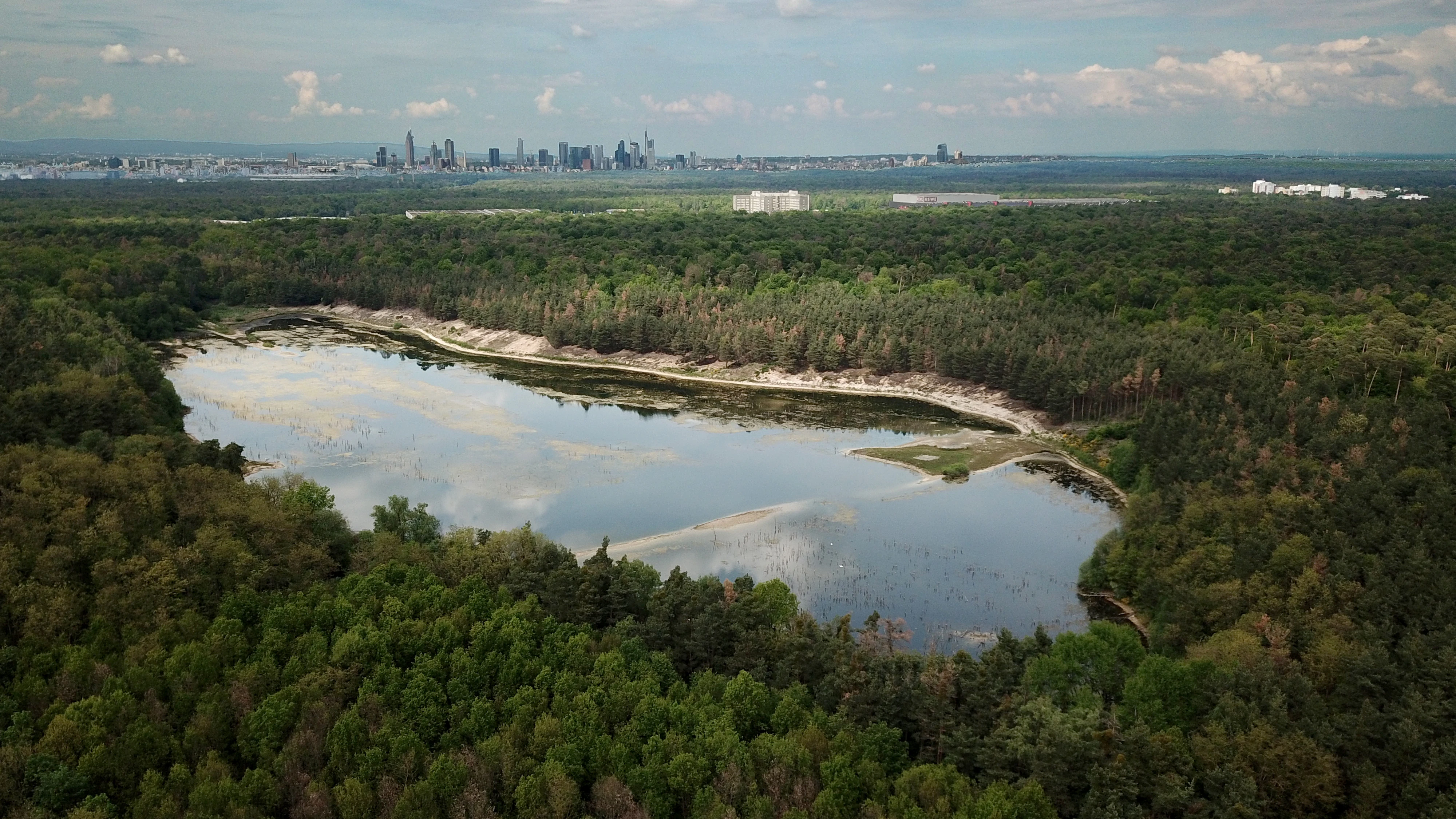
An aerial view of the Gehspitzweiher pond surrounded by a dense forest, with a modern urban skyline on the distant horizon.
Aerial view of the Gehspitzweiher nature reserve with the Frankfurt skyline visible in the distance.

Gehspitzweiher bei Neu-Isenburg history and protected-area timeline

The history of Gehspitzweiher is fundamentally a story of industrial use that gave way to conservation value. Excavation began as early as the 18th century, when clay deposits in the Alten Heegwald were exploited to supply a local brickworks. In 1872 the construction company Philipp Holzmann acquired approximately ten morgen of land along the Sprendlinger Weg, together with the brickmaking facilities. The site expanded into a sizeable industrial operation with its own rail connection to Neu-Isenburg.

From 1945 onward, clay extraction was successively replaced by deeper gravel mining using wet dredging techniques. The resulting pit deepened and widened, and by the early 1960s the water-filled basin was informally used for swimming. Swim areas were eventually demarcated, and during this period the City of Frankfurt even explored plans to build a regatta course and an associated hotel at the site. In 1969, however, a drop of roughly five meters in the groundwater table was recorded, leaving the basin with only fragmented water bodies and exposed sandy ground. Swimming and the city's development plans were abandoned.

Around 1970, gravel extraction was largely halted. The sudden appearance of rare species, including little ringed plover and natterjack toad, drew the attention of ornithologists and conservationists, who produced initial expert assessments. To stabilize fish populations, a small deepening was created in the pit floor in 1976. In 1977 the Hessian Society for Ornithology and Nature Conservation (HGON) formally applied for the area to be designated as a nature reserve. Beginning the same year, reclamation efforts included reforestation of the southern and eastern slopes with grey alder, black locust, pine, and sea buckthorn. The official designation as a Naturschutzgebiet followed by legal ordinance on 20 November 1981, formalizing the site's transition from industrial wasteland to protected natural area.

Since designation, the reserve has continued to be the subject of expert study and management planning, including a 1977 vegetation assessment, a 1980 expert opinion, and a 1995 management plan. In 2016, efforts were made to develop a new conservation concept that better balances ecological protection with public interest and access.

Gehspitzweiher bei Neu-Isenburg landscape and geographic character

The physical landscape of Gehspitzweiher is defined by the contrast between the sunken pit basin and the surrounding level forested terrain. The roughly one-kilometer-long pit lies about 20 meters below the surrounding ground level, with slopes rising from moist margins at the bottom to dry, sun-exposed upper edges. Width generally varies between 200 and 300 meters, giving the basin an elongated, channel-like profile.

Within the basin, the surface is a patchwork of small standing water bodies, exposed sandy and gravelly ground, ruderal vegetation, and patches of woodland. The southern and eastern slopes, planted with grey alder, black locust, pine, and sea buckthorn, provide a transitional zone between open sand and the surrounding mature Alten Heegwald forest.

The site is embedded in a broader wooded landscape between Neu-Isenburg and Zeppelinheim, bordered by transport corridors including the B 44 road and the Main-Neckar railway. This creates a setting in which industrial infrastructure sits only a short distance from forest and protected habitat.

Gehspitzweiher bei Neu-Isenburg ecosystems, habitats, and plant life

Ecologically, Gehspitzweiher is defined by its character as a habitat mosaic in a transitional, successional state. Open pioneer habitats on bare sand and gravel coexist with regenerating woodland, while wet margins and small water bodies support amphibian and aquatic invertebrate communities.

The reserve is significant as a refuge for species that have become rare in the surrounding cultivated and urban landscapes. The combination of dry substrates and small water bodies creates an unusual juxtaposition in which sand-loving grasshoppers and pioneer plants occur close to amphibians and dragonflies that depend on standing water. Around 250 plant species have been recorded, a figure that reflects the wide range of substrate and moisture conditions present within the small area.

Replanting with grey alder, black locust, pine, and sea buckthorn has accelerated the development of woody cover on parts of the slope, producing a forest structure that contrasts with the open pioneer surfaces and enriches the overall habitat diversity.

Gehspitzweiher bei Neu-Isenburg wildlife and species highlights

Gehspitzweiher supports an unusually rich fauna for an area of its size. Bird surveys have documented 98 species, including several that are regionally or nationally notable: little ringed plover, common sandpiper, osprey, hobby, snipe, little grebe, great crested grebe, and kingfisher. The presence of such species helped trigger the original conservation efforts in the 1970s.

Amphibians are another major highlight. Eight species are present, including natterjack toad, tree frog, agile frog, common frog, alpine newt, smooth newt, common toad, and water frog. The breeding population of natterjack toad has been particularly important to the reserve's conservation profile.

The invertebrate fauna is similarly significant. Twenty-six dragonfly species have been recorded, including the rare Leucorrhinia caudalis, first discovered here in 2009. Twenty grasshopper species and 18 butterfly species are present, alongside a wide variety of ground beetles and hymenopterans. The pit walls, old trees, and surrounding forest also support bat communities, adding a further faunal dimension to the reserve.

Gehspitzweiher bei Neu-Isenburg conservation status and protection priorities

Conservation at Gehspitzweiher centers on the protection of a recovering post-industrial landscape with high biodiversity value. The site is classified as an IUCN Category IV Habitat/Species Management Area, reflecting its active role in maintaining habitats and species rather than only preserving untouched nature. The official purpose of protection is the safeguarding of a successional refuge area for threatened amphibian and plant species.

Protection has been effective in stabilizing the area: industrial extraction has ceased, public construction plans for a regatta course and hotel were abandoned, and natural regeneration has been supported by targeted replanting on the most exposed slopes. In 2016, an effort was made to revise the conservation concept with the goal of better reconciling ecological protection with public interest.

The reserve is part of the wider network of protected areas in Landkreis Offenbach and is one of several former quarry or extraction sites in the district that have since become conservation areas, illustrating the role of secondary habitats in regional biodiversity strategies.

Gehspitzweiher bei Neu-Isenburg cultural meaning and human context

Gehspitzweiher's cultural context is closely tied to the industrial history of the Rhine-Main region. The site originated as a brickworks clay pit linked to a local tile factory before being purchased and expanded by the major construction company Philipp Holzmann in 1872. Over more than a century, the land was used successively for clay, sand, and gravel extraction, reflecting the intensive exploitation of local mineral resources during the industrialization of the Frankfurt region.

The transition from industrial extraction to nature protection, formalized in 1981, has its own cultural significance. Early advocates, including the HGON, framed the abandoned pit as a wildlife refuge rather than a wasted industrial site, helping to shift public perception of post-extractive landscapes. Today, the reserve represents both a local industrial heritage landmark and a community-supported conservation success.

Top sights and standout views in Gehspitzweiher bei Neu-Isenburg

The standout feature of Gehspitzweiher is the juxtaposition of habitats in a small area: open pioneer sand surfaces, young planted woodland, and sheltered water margins, all within a sunken basin surrounded by mature forest. Within these compressed habitats, 98 bird species, 8 amphibian species, 26 dragonfly species, and around 250 plant species have been recorded, creating a remarkable biodiversity density for a 25-hectore area in the middle of a metropolitan region.

Equally notable is the ecological arc of the site itself, from 18th-century brickworks clay pit to major industrial extraction operation, to abandoned pit briefly considered for urban resort development, and finally to formally protected nature reserve. Its role as one of many former quarries in Landkreis Offenbach that have become conservation areas also gives it broader regional significance for biodiversity strategies.

Best time to visit Gehspitzweiher bei Neu-Isenburg

Because Gehspitzweiher is a protected nature reserve managed for ecological value rather than active recreation, visit timing is best considered in terms of nature observation rather than seasonal tourism. Late spring and early summer tend to maximize amphibian and dragonfly activity at the water margins, while dawn and dusk typically bring the highest chance of seeing bird species and bats. Autumn can reveal seasonal change in the planted woodland and the transition between open sand habitats and forest. The reserve is an ecological site best appreciated for quiet observation across the milder months of the year.

Monthly climate preview

Long term temperature and precipitation cycles recorded across twelve months

Gehspitzweiher bei Neu-Isenburg Climate Normals and Annual Weather Patterns

Representative coordinate measurements track the annual temperature range and daily precipitation rates for Gehspitzweiher bei Neu-Isenburg from 1991 to 2020. Detailed monthly normals provide deeper insight into the long term climate rhythm established across Hesse.
Annual mean10 °C
0 °C21 °C
Jan
Feb
Mar
Apr10°
May14°
Jun18°
Jul21°
Aug20°
Sep15°
Oct10°
Nov
Dec
Warmest month
July

20.6 °C

Coolest month
January

0.2 °C

Wettest month
July

2.2 mm/day

Driest month
April

1.4 mm/day

Park location guide

Geography guide, regional context, and park location map for Gehspitzweiher bei Neu-Isenburg

Gehspitzweiher bei Neu-Isenburg park geography, regions, and map view in Germany

Understand where Gehspitzweiher bei Neu-Isenburg sits in Germany through a broader geographic reading of the surrounding landscape, nearby location context, and its mapped position within the national park landscape.

How Gehspitzweiher bei Neu-Isenburg fits into Germany

Germany is a federal republic in Western and Central Europe with a population of over 83 million across sixteen constituent states. It is Europe's largest economy by nominal GDP and a major global exporter and importer. The capital is Berlin, and the country borders Denmark, Poland, Czech Republic, Austria, Switzerland, France, Luxembourg, Belgium, and the Netherlands.

Wider geography shaping Gehspitzweiher bei Neu-Isenburg in Germany

Germany is located in Western and Central Europe, spanning 357,022 km². It borders Denmark to the north, Poland and the Czech Republic to the east, Austria and Switzerland to the south, and France, Luxembourg, Belgium, and the Netherlands to the west. The country has coastlines on the Baltic Sea and North Sea to the north, with the Alps located in the southern region.

Map view of Gehspitzweiher bei Neu-Isenburg

Use this park location map to pinpoint Gehspitzweiher bei Neu-Isenburg in Germany, understand its exact geographic position, and read its mapped placement within the surrounding landscape more clearly.

Pigeon | © OpenStreetMap contributors

Location context for Gehspitzweiher bei Neu-Isenburg

Hesse

Visual exploration of sunken quarry waters, pioneer sand slopes, and recovering woodland habitats.

Gehspitzweiher bei Neu-Isenburg Landscape Photos and Protected Area Scenery

Visual documentation of Gehspitzweiher bei Neu-Isenburg reveals the distinct terrain of a former extraction basin enclosed by mature forest. Detailed imagery exposes the ecological transition from industrial quarry to protected wetland sanctuary.

An aerial view of the Gehspitzweiher pond surrounded by a dense forest, with a modern urban skyline on the distant horizon.

A triangular green German nature reserve sign, showing a black raptor silhouette, attached to a pine tree, overlooking a scenic lake and forest landscape.

Park atlas

Compare regional nature reserves and connected post-industrial landscapes

Explore Protected Areas and Parks Near Gehspitzweiher bei Neu-Isenburg

Browse other protected areas and nature reserves located throughout the surrounding Rhine-Main region. Comparing these regional conservation sites provides broader context on post-industrial habitat regeneration and local biodiversity networks.
Nature reserveHessen
About 4.8 km away#1 closest

Southeast

Oberwiesen von Sprendlingen Nature Reserve: Landscape and Protected Area Geography

Wet meadows and seminatural grassland in the Hessen region

Located near Dreieich, Oberwiesen von Sprendlingen occupies seventeen hectares of diverse terrain where flat plains meet rolling hills. This nature reserve protects a documented array of fen fragments, reed beds, and tall herb stands, functioning as an ecological bridge within the regional network of protected Hessen landscapes.

Area
0.17 km²
Established
1996
IUCN
IV
Relief
Lowland
Nature reserveHessen
About 5.6 km away#2 closest

East

Luderbachaue von Dreieich: A Protected Floodplain Forest and Habitat in Hessen, Germany

Mapping the ecological geography of a significant lowland nature reserve

Spanning over 290 hectares, Luderbachaue von Dreieich serves as a major protected floodplain forest. The site preserves a diverse mosaic of oak, beech, and alder-ash woodlands that sustain rare fungal communities and old-growth timber, maintaining a vital green corridor in the urbanized Rhine-Main region.

Area
2.938 km²
Established
1996
IUCN
IV
Relief
Lowland
Nature reserveHessen
About 6.7 km away#3 closest

East

Bruch von Gravenbruch Nature Reserve: Geographic Profile and Protected Wetland Mapping

Hessen lowland moor and wetland habitat analysis

Examine the detailed terrain of Bruch von Gravenbruch, a notable nature reserve in Hessen characterized by its high groundwater table and intricate moisture-dependent ecosystems. The area serves as a key reference for studying lowland moor development, bog woodland structure, and the spatial distribution of protected wetland meadows across the regional landscape.

Area
0.932 km²
Established
1984
IUCN
IV
Nature reserveHessen
About 7.2 km away#4 closest

South

Kammereckswiesen und Herchwiesen von Langen: Protected Nature Reserve in Hessen, Germany

Geographic analysis of meadowland, grassland, and wetland habitat mosaic.

Kammereckswiesen und Herchwiesen von Langen serves as a significant nature reserve within the Rhine-Main area of Hessen. The site is defined by its unusual botanical diversity, derived from a close proximity of dry sandy soil and moisture-retaining clay patches. This atlas entry details the internal terrain structure, highlighting how traditional meadow management sustains rare dragonflies, butterflies, and orchids in this protected lowland landscape.

Area
28.8 km²
Established
1982
IUCN
IV
Nature reserveHesse
About 10 km away#5 closest

South

Faulbruch bei Erzhausen: Protected Wetland Landscapes and Regional Nature Reserve Atlas

Mapping rare fen woodlands and wet meadow habitats in southern Hesse

This nature reserve protects an ecologically distinct combination of black alder fen, mat grass pastures, and calcareous meadows near Erzhausen. Situated on silty, peaty soils within the southern Hessian lowlands, the site serves as a vital refuge for specialized biodiversity, maintained by its unique groundwater hydrology and surrounding anthropogenic borders.

Area
0.658 km²
Established
2001
Relief
Lowland
Climate
Temperate
A horizontal watercolor painting depicting a landscape with calm water, grassy marshlands, and distant rolling hills in soft pastel colors.
Nature reserveHessen
About 11 km away#6 closest

East

Nachtweide von Patershausen: Nature Reserve Geography and Mapped Protected Boundaries

Protected landscape and habitat atlas for the Hessen region

Nachtweide von Patershausen stands as a vital nature reserve in Hessen, characterized by a textured cultural landscape that includes rare nutrient-poor grassland and historical carp ponds. This protected site offers significant insight into the regional ecology of the Rhine-Main area, providing a dense mosaic of habitats that anchor the local natural environment near Heusenstamm.

Area
0.178 km²
Established
1987
IUCN
IV
Watercolor painting of a green wetland landscape with trees, grasses, and distant rolling hills on a white background.
Nature reserveHessen
About 12 km away#7 closest

East

Erlensteg von Bieber Nature Reserve: Geographic Map and Protected Habitat Overview

Compact wetland and forest mosaic in the Hessen region

Erlensteg von Bieber preserves a rare concentration of habitat types within a small footprint. From its moist floodplain meadows and sedge wetlands to its drier forest glades and fallow fields, this reserve showcases vital conservation management in the Rhine-Main area of Germany.

Area
0.752 km²
Established
1996
IUCN
IV
A watercolor painting showing a soft, bright landscape with green rolling hills, distant trees, and scattered yellow wildflowers.
Nature reserveHessen
About 12 km away#8 closest

Southeast

Im Mörsbacher Grund von Darmstadt-Arheilgen: Geography and Protected Wetland Atlas

Nature reserve landscape mapping in Hessen, Germany

Explore the structured landscape of Im Mörsbacher Grund von Darmstadt-Arheilgen. This nature reserve provides essential habitat connectivity through its wet meadows, orchids, and alluvial woodlands along the Hahnwiesenbach stream, representing an important segment of the regional conservation network.

Area
0.681 km²
Established
1987
IUCN
IV
Scope
Terrestrial

Common questions about visiting, size, designation, and location context for Gehspitzweiher bei Neu-Isenburg

Gehspitzweiher bei Neu-Isenburg FAQs for park facts, access, geography, and protected area context

Find quick answers about Gehspitzweiher bei Neu-Isenburg, including protected-area facts, park geography, trail and visitor context, and how the park fits into its surrounding country and regional landscape.
MoriAtlas Explorer

Continue Your Protected Areas Search Across the Global Atlas

Deepen your exploration by continuing the structured search for national parks and protected areas worldwide. Utilize the comprehensive filtering capabilities to compare different conservation landscapes and refine your understanding of global park geography. Discover more about the distribution and characteristics of protected natural areas.

Global natural geography