Mori Atlas logo
Nature reserveFaulbruch bei Erzhausen

Tracing the mapped boundaries of fragmented black alder fen and rare molinia meadows

Faulbruch bei Erzhausen Nature Reserve and Protected Wetland Landscape Geography in Hesse

(Naturschutzgebiet Faulbruch bei Erzhausen)

Faulbruch bei Erzhausen represents a critical protected refuge in southern Hesse, characterized by a complex mosaic of wet meadows, woodland fragments, and bog influenced habitats. This nature reserve serves as an essential ecological nexus, preserving rare submontane mat grass pastures and calcareous molinia meadows on silty, peaty substrates. The area functions as a vital wetland drainage corridor, providing a refuge for specialized flora and fauna within a heavily developed regional landscape.

wetlandnature reserveblack alder fenmolinia meadowmat-grass pasturesouthern hesse

Faulbruch bei Erzhausen

Nature reserve

Park overview

Structured park overview, official facts, and landscape profile for Faulbruch bei Erzhausen

Faulbruch bei Erzhausen park facts, protected area profile, and essential visitor context

Review the core facts for Faulbruch bei Erzhausen, including designation, size, terrain, visitor scale, habitats, and operating context in one park-focused overview.

About Faulbruch bei Erzhausen

Faulbruch bei Erzhausen is a compact but ecologically rich nature reserve in southern Hesse that protects one of the few remaining semi-natural wetland complexes on the eastern edge of Erzhausen, near the boundary with Egelsbach. Although it is a small site in absolute terms, it carries disproportionate importance locally because the surrounding region between Darmstadt, Egelsbach, and the Frankfurt airport corridor is dominated by urban development, transport infrastructure, and intensive agriculture. Within that context, the reserve functions as a relatively undisturbed refugium for bog-edge habitats and species-rich wet grassland that have largely vanished elsewhere in the Rhine-Main lowlands.

The reserve consists of three neighboring parcels, the largest of which lies east of the Frankfurt-Heidelberg railway line and a smaller fragment to the west of the tracks. A very small portion in the north belongs administratively to Egelsbach. The site is crossed by Kreisstraße 167 and is otherwise accessed through a network of forest tracks. The mix of three parcels gives the reserve a fragmented but interconnected character, and the protection regime ensures that the hedgerow and woodland edges between them continue to support moisture-loving vegetation.

The defining ecological identity of the Faulbruch is its combination of two rare habitat types in close proximity: a species-rich, submontane Borstgrasweide (mat-grass pasture) developed on silicate soils, and Molinia caerulea-dominated Pfeifengraswiesen (purple moor-grass meadows) on calcareous, peaty, and clayey-silty substrate. These habitats coexist with woodland fragments, partially drained wet meadows, small temporary pools, reed beds, and remnants of the original black alder fen woodland that the area's name commemorates. The reserve's Natura 2000 status through the FFH site Faulbruch von Erzhausen underlines its role in the European ecological network for the conservation of these habitats.

For visitors and researchers, the Faulbruch offers a representative example of how centuries of gradual drainage, land-use change, and forest succession can transform a once-uniform alder carr landscape into a patchwork of habitats. Although the area is partially drained and the tree cover is today considered to have limited commercial value, the underlying hydrology still produces seasonal flooding in spring and supports a distinctive seasonal cycle of saturation, drying, and renewed growth that underpins the area's botanical richness.

Quick facts and research context for Faulbruch bei Erzhausen

Faulbruch bei Erzhausen is a designated nature reserve (NSG 1432028) in the southern German state of Hesse, on the edge of Erzhausen in the Darmstadt-Dieburg and Offenbach district border area. The reserve covers approximately 65.75 hectares across three adjoining parcels and was legally designated on 2 August 2001. A southeastern portion of the area is additionally protected as the Fauna-Flora-Habitat site Faulbruch von Erzhausen (DE-6017-306), covering about 15.2 hectares.

The reserve lies east of the Frankfurt-Heidelberg railway line, with a small western fragment on the opposite side of the tracks, and is crossed by Kreisstraße 167. Its ecological profile is defined by high, base-rich groundwater that historically supported black alder fen woodland but now maintains a partially drained mosaic of forest, wet grassland, Molinia meadows, and mat-grass pasture.

Protection and recognition

Documented terrestrial protection metrics and official international recognition records

Faulbruch bei Erzhausen Protection Status and Designated Area Record

Faulbruch bei Erzhausen maintains a recorded terrestrial conservation status within global protected area inventories. Official records compile management scope, designation metrics, and international recognition data without external attribution.

Protection details

Protection scope
Terrestrial
Transboundary protection
No
WDPA ID
318383
Park context

Deeper park guide and search-rich context for Faulbruch bei Erzhausen

Faulbruch bei Erzhausen history, landscape, wildlife, and travel context

Explore Faulbruch bei Erzhausen through its history, landscape character, ecosystems, wildlife, conservation priorities, cultural context, and seasonal travel timing in a structured park guide built for atlas discovery and search intent.

Why Faulbruch bei Erzhausen stands out

Faulbruch bei Erzhausen is best known for preserving a fragmented but ecologically distinctive combination of submontane mat-grass pastures on silicate soil and calcareous Molinia caerulea wet meadows, soils that are rare in the surrounding lowlands of southern Hesse. The reserve is also recognized for retaining traces of the original black alder fen woodland (Bruchwald) that once dominated the wetland, set against a landscape otherwise dominated by agricultural and urban land use. Beyond the habitat mosaic, the site is valued as a small-scale refuge for wetland-dependent flora such as mat grass (Nardus stricta), purple moor-grass (Molinia caerulea), grey willow (Salix cinerea), and black alder (Alnus glutinosa), along with characteristic wetland fauna including the Jersey tiger moth (Euplagia quadripunctaria).
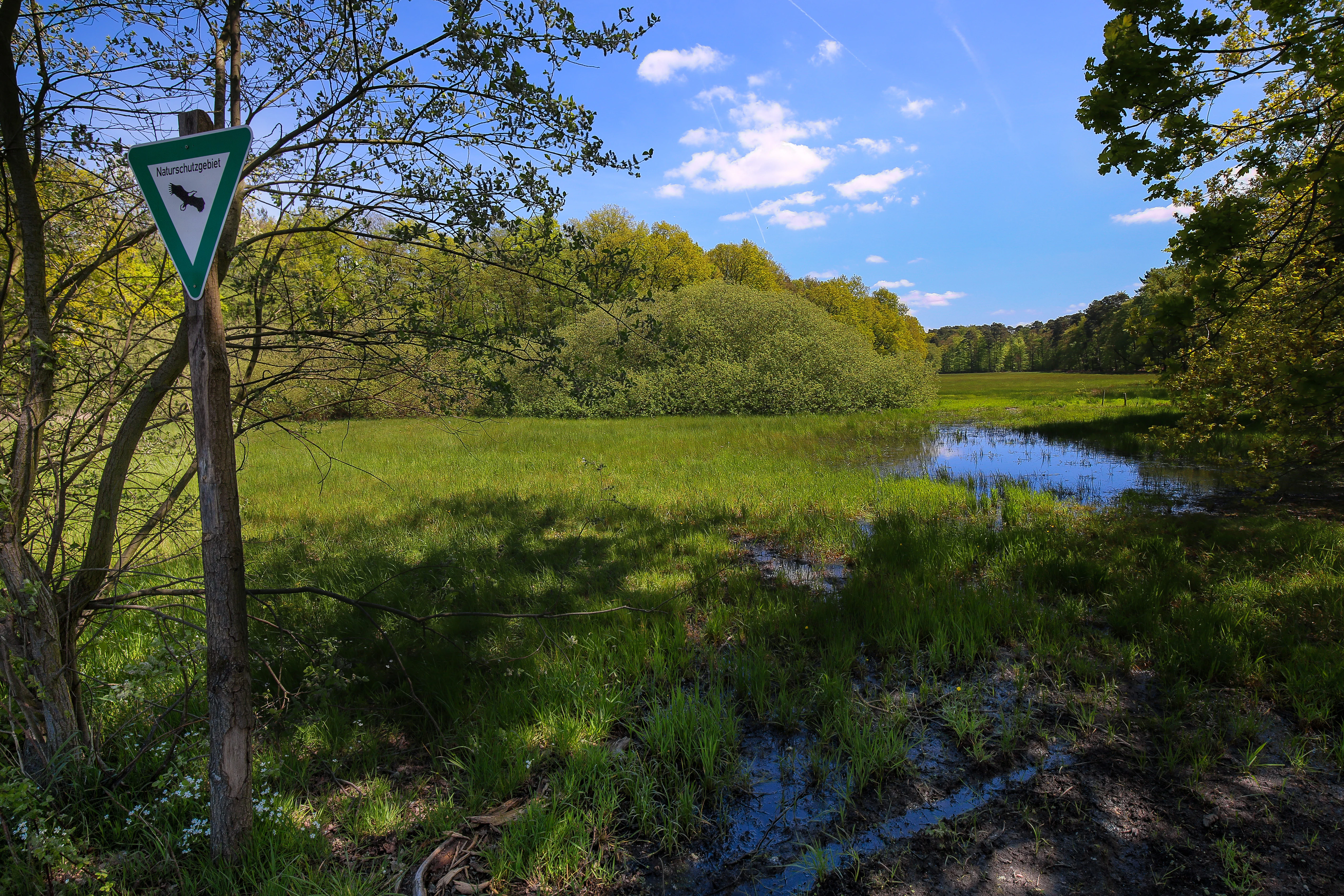
A green, grassy wetland meadow with a small pond surrounded by trees, viewed under a blue sky. A triangular nature reserve sign is mounted on a wooden post in the foreground left.
A green meadow and small pond in the Faulbruch nature reserve near Erzhausen, Germany.

Faulbruch bei Erzhausen history and protected-area timeline

The name of the site reveals a long history of human association with the wetland. Historical forms of the name appear in records from 1497 ("Im faulen bruch"), 1658 ("im fauhl Bruch"), 1767 ("im faulen Bruch"), and the 19th century ("Das Faulbruch"), with the name continuing in use through the 20th and 21st centuries. The German elements both describe unproductive, swampy ground: "Faul" derives from Old High German fûl and Middle High German vûl, meaning rotten or decayed, while "Bruch" from Old High German bruoch refers to boggy moorland and swampy meadow soil. The name thus reflects centuries of local recognition of the area as a distinctive wet, poorly drained zone.

Until modern drainage efforts gradually altered the water balance, the Faulbruch is believed to have been a near-pure black alder and grey willow fen woodland, sustained by high, base-rich groundwater slowly moving through the substrate. Over time, partial drainage converted much of the original alder carr into a mixed wetland forest interspersed with forest meadows and wet grassland.

The area's modern conservation history began on 2 August 2001, when it was formally designated as a nature reserve (Naturschutzgebiet) under the identifier 1432028 through a regulatory ordinance. The designation covered 65.75 hectares and aimed to secure the remaining habitat mosaic for long-term protection. A southeastern portion of the reserve was subsequently recognized within the European Natura 2000 network as the Fauna-Flora-Habitat site Faulbruch von Erzhausen (DE-6017-306), covering approximately 15.2 hectares and integrating the reserve into broader European conservation planning for these habitat types.

Faulbruch bei Erzhausen landscape and geographic character

The Faulbruch occupies a low-lying position in the southern Hessian landscape at around 50 degrees north and just under 9 degrees east, set on soils with a high, slowly moving groundwater table. The terrain is flat to gently undulating and is shaped primarily by hydrology rather than dramatic relief. The reserve sits at about 65 meters elevation and is crossed by local transportation corridors that help define its boundaries.

The most striking physical feature of the area is its soil and water system. A thick layer of fen-peat (Bruchwaldtorf or Bruchwaldfehn), built up from wood and cone residues, lies beneath parts of the reserve. In spring, before the vegetation period begins, the combination of high groundwater and runoff produces prolonged flooding and surface saturation across large parts of the site. Later in the year, near-surface drying becomes an important ecological factor, supporting nitrogen mineralization and oxygen supply that allow regeneration of the shallow-rooted black alder.

Above the wetland substrate, the reserve presents a visually varied mosaic of forest stands, wet meadows, reed beds, and small temporary pools, with the railway embankment and Kreisstraße 167 providing clear anthropogenic edges. The interplay between saturated low-lying areas and neighboring drier forest patches gives the reserve its distinctive landscape character.

Faulbruch bei Erzhausen ecosystems, habitats, and plant life

Ecologically, the Faulbruch is anchored by two rare and contrasting grassland habitats that occur side by side: a submontane Borstgrasweide on silicate soils, and Molinia caerulea Pfeifengraswiesen on calcareous, peaty, and clayey-silty soils. These habitats are of high conservation interest because they reflect a transitional submontane character uncommon in the surrounding lowlands.

Where the original hydrology persists, the woodland takes the form of alder carr (Bruchwald) dominated by black alder (Alnus glutinosa) and grey willow (Salix cinerea), belonging to the Alnetea glutinosae community. In the understory of these wet woodlands, the high water table suppresses typical broadleaf forest species and encourages the establishment of swamp plants normally associated with wet meadows and reed beds. The thick fen-peat horizon contains preserved wood and cone fragments, reflecting the long history of organic accumulation in the wetland.

A century of partial drainage has shifted parts of the reserve toward plant communities generally associated with drier or more disturbed conditions. Recent vegetation surveys classify the reserve as a mosaic dominated by acidophilic beech forest, mixed stands that include coniferous plantings, and fragmented open wetlands. Wet grassland, Molinion meadows, reed beds, wet braches, tall-herb vegetation, and small patches of mat-grass turf each contribute to the ecological texture of the site, while the network of forest tracks and small drainage channels influences how these habitats interconnect.

Faulbruch bei Erzhausen wildlife and species highlights

The wildlife interest of the Faulbruch is closely tied to its mosaic of wetland, woodland, and meadow habitats. The reserve's species inventory reflects the importance of small, structurally varied protected areas for maintaining invertebrate and plant diversity in heavily developed regions.

Among the most notable fauna documented for the site is the Jersey tiger moth (Euplagia quadripunctaria), a striking day-flying moth whose presence in the reserve is recognized as regionally significant. Historical records also document the dusky large blue butterfly (Maculinea nausithous), a highly specialized species tied to wet meadows with great burnet (Sanguisorba officinalis) host plants, as having been present in the Faulbruch until 2001, illustrating both the conservation value of the site and the vulnerability of meadow specialists to drainage and land-use change.

The wet woodland, reed beds, and small temporary pools provide habitat for a broader community of wetland-associated invertebrates, amphibians, and birds typical of southern Hessian lowland wetlands, although detailed species lists are limited. The continued importance of the reserve for such wildlife lies in its combination of structurally varied habitats within a small footprint.

Faulbruch bei Erzhausen conservation status and protection priorities

Faulbruch bei Erzhausen is a small but strategically placed contribution to nature conservation in southern Hesse, where the surrounding landscape has been transformed by urban expansion, transport infrastructure, and intensive agriculture. The 2001 designation of the 65.75-hectare reserve secured the legal protection of a habitat mosaic that would otherwise be highly vulnerable to further drainage, intensification, or land conversion.

A southeastern portion of the reserve has been integrated into the European Natura 2000 network as the Fauna-Flora-Habitat site Faulbruch von Erzhausen (DE-6017-306), covering about 15.2 hectares. This dual designation reflects the high conservation value of the area's mat-grass pastures, Molinia wet meadows, and wet woodland for European habitat types that have become scarce across much of central Europe.

Conservation management challenges at the site are typical of small lowland wetland reserves: partial drainage continues to affect parts of the area, leading to gradual loss of the most valuable wet habitats. The presence of mixed forest stands of limited timber value, alongside planted conifers, suggests that balancing hydrological restoration with the maintenance of existing open habitats will be central to the site's long-term conservation strategy. The reserve's profile as a habitat for specialized species such as Maculinea nausithous underscores the high stakes of maintaining appropriate management practices.

Faulbruch bei Erzhausen cultural meaning and human context

The cultural context of the Faulbruch is rooted in the long-standing relationship between local communities and the unproductive, swampy ground that defines the site. The continuity of the name from the late 15th century through to the present day reflects recognition of the area as a distinctive and economically marginal piece of land within the agrarian landscape south of Darmstadt, where wet, peaty soils were traditionally avoided for cultivation and instead used as pasture, woodland, or rough grazing.

The reserve fits into the broader pattern of southern Hessian nature protection, sitting within both the Darmstadt-Dieburg and Offenbach administrative regions. Its historical woodland meadows (Waldwiesen), including the named Bauerswiese, Sauwiese, and Faulbruchwiese, preserve traces of traditional open-land systems embedded within the forested wetland. Modern protection designations in 2001 and subsequent Natura 2000 recognition brought this long-standing cultural landscape into a new framework of ecological conservation rather than economic land use.

Top sights and standout views in Faulbruch bei Erzhausen

The reserve's standout quality is its compact combination of three habitat types rarely found together in such close proximity at this latitude: submontane mat-grass pasture on silicate soils, calcareous Molinia wet meadows, and remnant black alder fen woodland. This habitat triumvirate, sustained by the area's distinctive groundwater hydrology, sets the Faulbruch apart from the majority of surrounding lowland sites in southern Hesse.

Further standout features include the reserve's role in the European Natura 2000 network through the Faulbruch von Erzhausen FFH site, its designation as a state-level nature reserve in 2001, and its function as a refuge for specialized wetland species such as Euplagia quadripunctaria in a landscape dominated by transport corridors and settlement.

Best time to visit Faulbruch bei Erzhausen

The Faulbruch is a low-lying wetland reserve whose character shifts strongly with the seasons. In early spring, before the vegetation period is fully underway, the high groundwater table combined with snowmelt and rainfall produces prolonged surface flooding and saturation across much of the site, a dynamic that is central to the area's ecological identity. As the year progresses, surface drying allows the soils to aerate, supporting the growth of mat-grass pastures and Molinia meadows.

For visitors interested in experiencing the habitat mosaic and the seasonal hydrological cycle, late spring through early autumn generally offers the most accessible combinations of flowering meadows, drier forest paths, and active invertebrate life. Winter and early spring visits can reveal the saturated character of the landscape but require appropriate footwear and tolerance for wet conditions on forest tracks.


Monthly climate preview

Long-term representative monthly temperature and precipitation patterns across the protected coordinate

Faulbruch bei Erzhausen Climate Normals and Annual Temperature Rhythm

Faulbruch bei Erzhausen exhibits a measured annual temperature and precipitation rhythm derived from long-term representative coordinate records spanning multiple decades. Examining the complete monthly climate profile reveals detailed temperature extremes and precipitation averages across the protected area.
Annual mean10 °C
0 °C21 °C
Jan
Feb
Mar
Apr10°
May14°
Jun18°
Jul21°
Aug20°
Sep15°
Oct10°
Nov
Dec
Warmest month
July

20.6 °C

Coolest month
January

0.2 °C

Wettest month
July

2.2 mm/day

Driest month
April

1.4 mm/day

Park location guide

Geography guide, regional context, and park location map for Faulbruch bei Erzhausen

Faulbruch bei Erzhausen park geography, regions, and map view in Germany

Understand where Faulbruch bei Erzhausen sits in Germany through a broader geographic reading of the surrounding landscape, nearby location context, and its mapped position within the national park landscape.

How Faulbruch bei Erzhausen fits into Germany

Germany is a federal republic in Western and Central Europe with a population of over 83 million across sixteen constituent states. It is Europe's largest economy by nominal GDP and a major global exporter and importer. The capital is Berlin, and the country borders Denmark, Poland, Czech Republic, Austria, Switzerland, France, Luxembourg, Belgium, and the Netherlands.

Wider geography shaping Faulbruch bei Erzhausen in Germany

Germany is located in Western and Central Europe, spanning 357,022 km². It borders Denmark to the north, Poland and the Czech Republic to the east, Austria and Switzerland to the south, and France, Luxembourg, Belgium, and the Netherlands to the west. The country has coastlines on the Baltic Sea and North Sea to the north, with the Alps located in the southern region.

Map view of Faulbruch bei Erzhausen

Use this park location map to pinpoint Faulbruch bei Erzhausen in Germany, understand its exact geographic position, and read its mapped placement within the surrounding landscape more clearly.

Pigeon | © OpenStreetMap contributors

Location context for Faulbruch bei Erzhausen

Hesse

Visual reference for wetland habitats, black alder fen terrain, and protected protected-area character

Faulbruch bei Erzhausen Photos and Landscape Scenery Exploration

Visual records document the distinct mosaic of wet meadows, woodland fragments, and bog-influenced habitats defining the protected area. Examining these environmental details provides clear insight into the rare lowland ecosystems and hydrology sustaining the reserve.

A green, grassy wetland meadow with a small pond surrounded by trees, viewed under a blue sky. A triangular nature reserve sign is mounted on a wooden post in the foreground left.

Park atlas

Compare regional wetland reserves and surrounding lowland ecosystems

Explore Protected Areas and Parks Near Faulbruch bei Erzhausen

Browsing parks near Faulbruch bei Erzhausen reveals the wider network of protected wetland habitats and lowland nature reserves across southern Hesse. Comparing adjacent conservation areas provides essential context on regional biodiversity patterns and remnant fen landscapes.
Nature reserveHessen
About 3.2 km away#1 closest

North

Kammereckswiesen und Herchwiesen von Langen: Protected Nature Reserve in Hessen, Germany

Geographic analysis of meadowland, grassland, and wetland habitat mosaic.

Kammereckswiesen und Herchwiesen von Langen serves as a significant nature reserve within the Rhine-Main area of Hessen. The site is defined by its unusual botanical diversity, derived from a close proximity of dry sandy soil and moisture-retaining clay patches. This atlas entry details the internal terrain structure, highlighting how traditional meadow management sustains rare dragonflies, butterflies, and orchids in this protected lowland landscape.

Area
28.8 km²
Established
1982
IUCN
IV
A watercolor painting showing a soft, bright landscape with green rolling hills, distant trees, and scattered yellow wildflowers.
Nature reserveHessen
About 4 km away#2 closest

East

Im Mörsbacher Grund von Darmstadt-Arheilgen: Geography and Protected Wetland Atlas

Nature reserve landscape mapping in Hessen, Germany

Explore the structured landscape of Im Mörsbacher Grund von Darmstadt-Arheilgen. This nature reserve provides essential habitat connectivity through its wet meadows, orchids, and alluvial woodlands along the Hahnwiesenbach stream, representing an important segment of the regional conservation network.

Area
0.681 km²
Established
1987
IUCN
IV
Scope
Terrestrial
A pale, soft watercolor landscape painting of a quiet lake with shoreline reeds, trees in the background, and branches framing the scene on the sides.
Nature reserveHesse
About 4.4 km away#3 closest

Southwest

Am Kleewoog von Gräfenhausen Nature Reserve: Geography and Protected Area Landscape Overview

A regional sanctuary of sand habitats and former gravel pits in Hesse

Examine the distinct ecological geography of Am Kleewoog von Gräfenhausen. This reserve showcases the transition between rugged, water-filled gravel excavations and stable pine-oak forest stands on acidic inland dunes. Gain insight into the regional importance of this protected mosaic as an amphibian refuge and a remnant of the unique geological substrate found across the Darmstadt sand sheet.

Area
0.209 km²
Established
1985
IUCN
IV
Relief
Lowland
Nature reserveHessen
About 8.8 km away#4 closest

North

Oberwiesen von Sprendlingen Nature Reserve: Landscape and Protected Area Geography

Wet meadows and seminatural grassland in the Hessen region

Located near Dreieich, Oberwiesen von Sprendlingen occupies seventeen hectares of diverse terrain where flat plains meet rolling hills. This nature reserve protects a documented array of fen fragments, reed beds, and tall herb stands, functioning as an ecological bridge within the regional network of protected Hessen landscapes.

Area
0.17 km²
Established
1996
IUCN
IV
Relief
Lowland
Watercolor painting of a rolling wetland landscape featuring green fields, soft hills in the background, and marshy foreground vegetation.
Nature reserveHessen
About 9.1 km away#5 closest

Southeast

Scheftheimer Wiesen Nature Reserve: Geographic Overview and Protected Landscape Mapping

Hessen wetland ecosystems and prehistoric heritage sites

Situated along the Ruthsenbach stream in Hessen, Scheftheimer Wiesen is a 166-hectare nature reserve known for its recovery of wet meadow habitats after decades of agricultural use. The area integrates natural terrain with cultural heritage, featuring reconstructed granite menhirs and historic burial mounds within a broader forest-framed environment near Darmstadt.

Area
1.661 km²
Established
1993
IUCN
IV
Relief
Lowland
A horizontal watercolor illustration depicting a soft, pastel-colored meadow with wildflowers in the foreground and a gentle forest line in the background against a white background.
Nature reserveLandkreis Darmstadt-Dieburg
About 9.2 km away#6 closest

East

Neuwiese von Messel Nature Reserve: Mapped Geography and Protected Landscape Context

Essential nature reserve located in Landkreis Darmstadt-Dieburg

Neuwiese von Messel consists of open meadow islands surrounded by mature deciduous forest, creating a representative forest-meadow mosaic in the Messeler Hügelland. This nature reserve functions as a vital conservation site for specialized plants and habitat types, protected within the European Natura 2000 network. Gain insight into its terrain, soil-based biodiversity, and the centuries-old traditional management that sustains this protected German landscape.

Area
1.072 km²
Established
1986
IUCN
IV
Relief
Lowland
Nature reserveHessen
About 9.4 km away#7 closest

Northeast

Luderbachaue von Dreieich: A Protected Floodplain Forest and Habitat in Hessen, Germany

Mapping the ecological geography of a significant lowland nature reserve

Spanning over 290 hectares, Luderbachaue von Dreieich serves as a major protected floodplain forest. The site preserves a diverse mosaic of oak, beech, and alder-ash woodlands that sustain rare fungal communities and old-growth timber, maintaining a vital green corridor in the urbanized Rhine-Main region.

Area
2.938 km²
Established
1996
IUCN
IV
Relief
Lowland
Soft watercolor illustration of a calm, marshy wetland scene with reeds, a lone bare tree on the left, and a soft forest line in the background.
Nature reserveHessen
About 9.6 km away#8 closest

Southwest

Löserbecken von Weiterstadt Nature Reserve in Hessen: A Detailed Geographic Overview

Protected landscape within the Upper Rhine Plain

Löserbecken von Weiterstadt protects a distinct basin landscape characterized by the interaction between former sand extraction slopes and naturally forming rainwater wetlands. This reserve showcases the transformation of post-industrial ground into a high-value habitat for crested newts and other species. Explore the boundaries and topographic features of this compact, protected Hessen nature area.

Area
0.08 km²
Established
1983
IUCN
IV

Common questions about visiting, size, designation, and location context for Faulbruch bei Erzhausen

Faulbruch bei Erzhausen FAQs for park facts, access, geography, and protected area context

Find quick answers about Faulbruch bei Erzhausen, including protected-area facts, park geography, trail and visitor context, and how the park fits into its surrounding country and regional landscape.
MoriAtlas Explorer

Continue Your Protected Areas Search Across the Global Atlas

Deepen your exploration by continuing the structured search for national parks and protected areas worldwide. Utilize the comprehensive filtering capabilities to compare different conservation landscapes and refine your understanding of global park geography. Discover more about the distribution and characteristics of protected natural areas.

Global natural geography