
Mori Atlas logo
Protected landscapeGengenbachtal und Dolinenlandschaft südlich Göbrichen

Mapping the distinctive stream valley meadows and unique karst sinkhole geography of the Enzkreis district

Gengenbachtal und Dolinenlandschaft südlich Göbrichen: A Regional Protected Landscape in Baden-Württemberg

(Landschaftsschutzgebiet "Gengenbachtal und Dolinenlandschaft südlich Göbrichen")

Gengenbachtal und Dolinenlandschaft südlich Göbrichen preserves two ecologically significant settings within the Enzkreis district. The protected area features the wooded Gengenbach valley, characterized by stream-side meadows and steep slopes, alongside a sinkhole-rich karst basin in the Kraichgau region. This landscape mosaic highlights the transition between the northern Black Forest foothills and the limestone plateau of the Gäu, offering a valuable record of regional karst morphology.

landscape protection areaprotected landscapeIUCN Category Vbrooks and valleysmeadow valleywooded valley slopes
A flat-style digital illustration depicting a valley with steep canyon walls, a waterfall, and a winding river surrounded by simplified trees and clouds.

Gengenbachtal und Dolinenlandschaft südlich Göbrichen

Protected landscape

Park overview

Structured park overview, official facts, and landscape profile for Gengenbachtal und Dolinenlandschaft südlich Göbrichen

Gengenbachtal und Dolinenlandschaft südlich Göbrichen park facts, protected area profile, and essential visitor context

Review the core facts for Gengenbachtal und Dolinenlandschaft südlich Göbrichen, including designation, size, terrain, visitor scale, habitats, and operating context in one park-focused overview.

About Gengenbachtal und Dolinenlandschaft südlich Göbrichen

Gengenbachtal und Dolinenlandschaft südlich Göbrichen is one of many regional landscape protection areas that together form the backbone of countryside preservation in the Enzkreis of Baden-Württemberg. Although modest in size at roughly 340 hectares, it packs considerable landscape diversity into its two part-areas, and it is mainly through this combination of valley and doline landscape that the site is locally distinctive.

The Gengenbach valley section lies southeast of Königsbach-Stein, where the small Gengenbach stream flows through a narrow, traditionally used meadow valley. The slopes on either side remain forested, giving the valley the impression of an intact, almost untouched Wiesental, a meadow valley of the kind that has become increasingly rare in the densely settled landscapes of Baden-Württemberg. The protection ordinance specifically calls out the unspoiled character of this valley and the forested hillsides that enclose it as the reason for protection.

The second part-area is set roughly four kilometers away and lies south of Göbrichen, within the natural region of the Kraichgau and the greater naturräumliche unit of the Neckar- und Tauber-Gäuplatten. Here, the focus of protection shifts from a valley landscape to a karst phenomenon: a closed basin in which numerous dolines, or sinkholes, are scattered across a network of meadows, reed beds, scrub and trees of differing moisture regimes. This part of the landscape protection area functions as a buffer and complement to the small but ecologically important Naturschutzgebiet Neulinger Dolinen, which it surrounds.

More broadly, the protection area reflects how local and regional authorities in the Enzkreis have used the landscape protection designation to maintain the visual character and ecological value of small-scale countryside features, often bridging the gap between strict nature reserve protection and ordinary agricultural land use.

Quick facts and research context for Gengenbachtal und Dolinenlandschaft südlich Göbrichen

Gengenbachtal und Dolinenlandschaft südlich Göbrichen is a Landscape Protection Area (Landschaftsschutzgebiet) with the official designation number 2.36.009, classified under IUCN Category V (Protected Landscape/Seascape) and recorded in the World Database on Protected Areas under WDPA ID 321017. It lies in the Enzkreis district of Baden-Württemberg, around the 48° 57′ N, 8° 43′ E coordinate range, and covers approximately 339.8 hectares across two part-areas and six municipalities.

The site was established on 31 July 1952 by an ordinance of the former Landratsamt Pforzheim and is now administered by the Landratsamt Enzkreis. It protects both the wooded Gengenbach valley southeast of Königsbach-Stein and a doline-rich meadow basin south of Göbrichen in the Kraichgau natural region. Parts of the area overlap with the Natura 2000 FFH site Pfinzgau Ost (site number 7017-341) and it borders the Eisinger Gäulandschaft Landscape Protection Area on both of its sections.

Protection and recognition

Examine the official protection status, management framework, and recognized designation records.

Gengenbachtal und Dolinenlandschaft südlich Göbrichen Protection Status and Designated Area Record

Gengenbachtal und Dolinenlandschaft südlich Göbrichen maintains a recorded protected area designation linked through international conservation databases. Archival records provide verified baseline metrics concerning the established conservation framework and regulatory oversight.

Protection details

WDPA ID
321017
Park context

Deeper park guide and search-rich context for Gengenbachtal und Dolinenlandschaft südlich Göbrichen

Gengenbachtal und Dolinenlandschaft südlich Göbrichen history, landscape, wildlife, and travel context

Explore Gengenbachtal und Dolinenlandschaft südlich Göbrichen through its history, landscape character, ecosystems, wildlife, conservation priorities, cultural context, and seasonal travel timing in a structured park guide built for atlas discovery and search intent.

Why Gengenbachtal und Dolinenlandschaft südlich Göbrichen stands out

The protected landscape is known for two contrasted but ecologically linked landscapes. Its first part preserves the Gengenbach valley as an unspoiled meadow valley framed on both sides by wooded slopes, a classic example of the small, forested brook valleys of the northwestern Black Forest foothills. Its second part, around Göbrichen in the Kraichgau, is valued above all for its striking karst features, particularly the dolines, or sinkholes, that punctuate a closed meadow basin around the Neulinger Dolinen nature reserve. Together these features make the site a representative example of how valley meadows and doline wetlands coexist in the transition zone between the Black Forest and the Gäu plateaus.
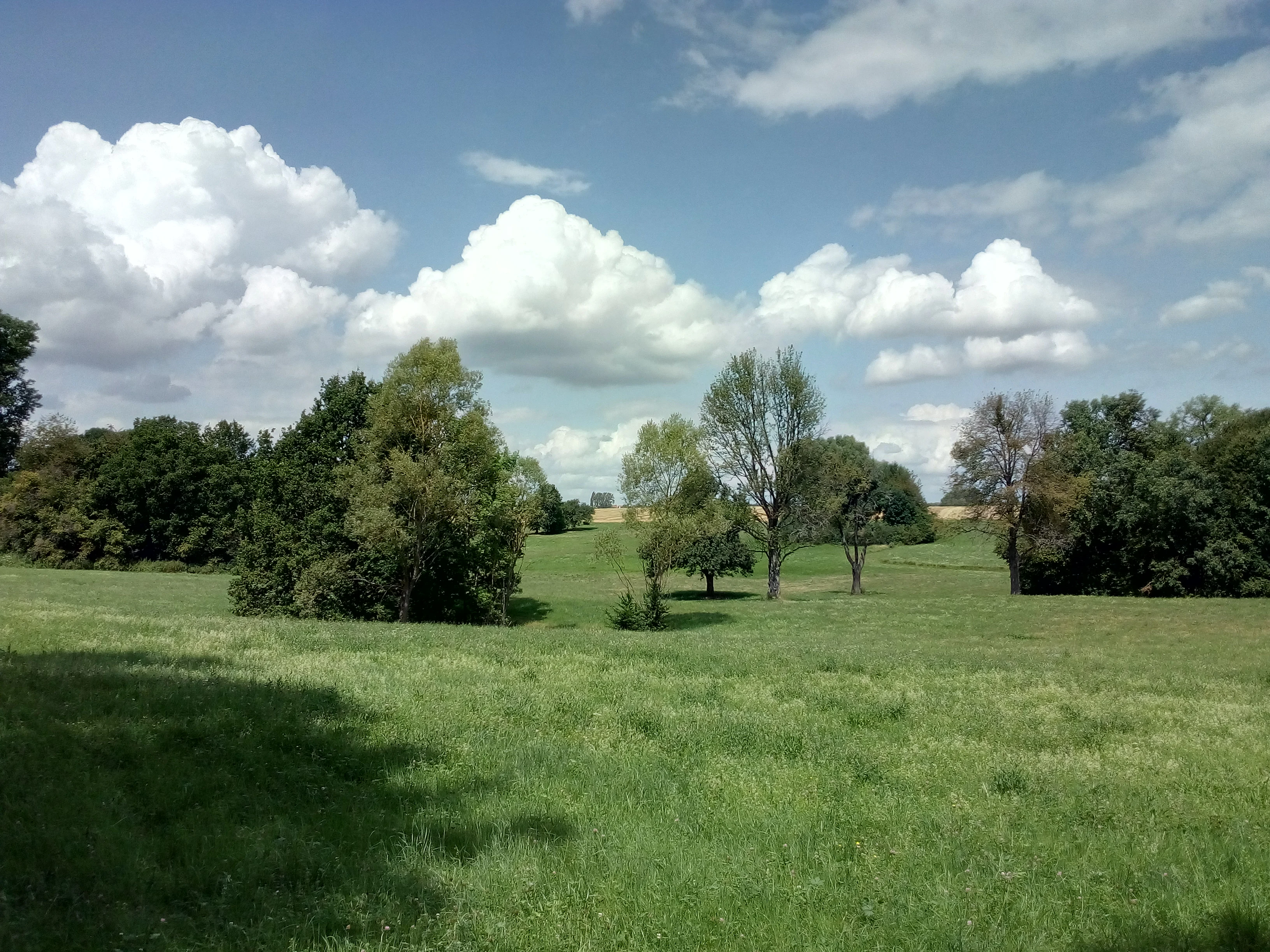
A green, open meadow with scattered trees and shrubs under a sky with fluffy cumulus clouds.
View of the open landscape in the Neulinger Dolinen area.

Gengenbachtal und Dolinenlandschaft südlich Göbrichen history and protected-area timeline

The protected landscape was established on 31 July 1952 by an ordinance (Verordnung) of the Landratsamt Pforzheim, the district office then responsible for the area. Its formation came during the broader post-war push in Germany to systematically protect representative countryside features through the Landschaftsschutzgebiet instrument, an older category in German nature conservation law designed to safeguard larger but less strictly protected rural landscapes.

After the administrative changes that transformed the former Landkreis Pforzheim into the modern Enzkreis district, responsibility for the protected area passed to the Landratsamt Enzkreis, which continues to administer it today. Over time, the protection area has also gained additional significance because portions of it now fall within the European Natura 2000 network through the FFH site Pfinzgau Ost (site number 7017-341), adding a layer of EU-level ecological recognition to its original regional designation.

Gengenbachtal und Dolinenlandschaft südlich Göbrichen landscape and geographic character

The landscape is best understood as two quite different but functionally related settings. The first part-area describes the narrow, wooded valley of the Gengenbach southeast of Königsbach-Stein: a mostly level meadow floor along the stream, with steep, forested slopes on either side. The combination of open meadows and adjacent woodlands gives the valley the classic profile of an unspoiled Wiesental in the foothill belt of the northern Black Forest, where small brooks have carved into the softer Triassic strata just beyond the crystalline massif.

The second part-area lies south of Göbrichen in the Kraichgau, a rolling cuesta country of loess and limestone that contrasts sharply with the higher Black Forest scenery. Here the topography is dominated by a closed basin in which the surface water has no visible outlet; instead, drainage takes place underground through karst conduits. This basin is dotted with dolines, the typical bowl-shaped sinkholes of karst terrain, which are the defining morphological feature of the area and give the protection area the second half of its name.

In between, the two part-areas together define a protected landscape mosaic that ranges from stream-side meadows and forested hillsides to moist meadow depressions, reed beds, scrub patches, and orchard-like tree stands in and around the dolines. The combined visual character, especially in the Göbrichen section, is unusual within Baden-Württemberg: karst dolines are concentrated here in a relatively small area and embedded directly within an agricultural matrix.

Gengenbachtal und Dolinenlandschaft südlich Göbrichen ecosystems, habitats, and plant life

The ecological value of the area rests less on the presence of single spectacular habitats than on the closeness of different habitat mosaics. In the Gengenbach valley, the protected landscape preserves the traditional structure of a small stream valley: moist meadows along the brook, slightly drier grasslands on the fringes, and continuous forests on the slopes that frame the open valley. This combination of habitats, looking almost unmodified compared to many other valleys in the region, has become a priority for conservation because such intact Wiesental structures have largely disappeared from much of the surrounding countryside.

Around Göbrichen, the doline landscape creates a very different set of habitats. Because each doline can hold water at different levels depending on its depth and its connection to the karst system, the meadows, reed beds (Röhrichte), scrub thickets, and tree groups around them vary from comparatively dry to distinctly moist. The ordinance specifically cites the different moisture regimes and resulting vegetation differences as one of the reasons for protection, along with the geological significance of the dolines themselves. Together with the neighboring Neulinger Dolinen nature reserve, the Landscape Protection Area forms a larger ecological complex in which the strict reserve provides core protection and the surrounding landscape protection area provides ecological continuity.

Gengenbachtal und Dolinenlandschaft südlich Göbrichen wildlife and species highlights

The source material emphasizes the ecological rather than faunal profile of the protected area, so wildlife descriptions must be read in that light. The mix of meadows, reed beds, scrub, and scattered trees around the Göbrichen dolines is the type of habitat mosaic that typically supports characteristic farmland and wetland species, including meadow birds, amphibians in the wetter doline depressions, and a diverse insect fauna associated with both dry grasslands and moist meadow vegetation. The wooded slopes of the Gengenbach valley additionally provide continuity with the broader forest fauna of the Black Forest fringe.

Gengenbachtal und Dolinenlandschaft südlich Göbrichen conservation status and protection priorities

From a conservation standpoint, the area illustrates how a relatively small, locally administered landscape protection area can serve multiple protection functions at once. Its original purpose was to safeguard the visual and ecological character of an unspoiled meadow valley and a karst basin under the German Landschaftsschutzgebiet instrument, a regional-level protection category weaker than a nature reserve but broader in scope.

The protection rationale combines landscape aesthetics, geomorphology, and ecology. The ordinance highlights the scenic meadow valley framed by forest, the picturesque mix of meadows, reed beds, and trees around the dolines, the geological importance of the karst features, and the ecological value of the variable moisture conditions across the doline meadows. By buffering and extending the Neulinger Dolinen nature reserve, the Göbrichen section also functions as a complementary protection area for a stricter reserve at its core.

The landscape protection area additionally sits within the larger Natura 2000 framework: parts of it overlap with the FFH site Pfinzgau Ost (7017-341), giving the area a degree of European-level habitat protection alongside its 1952 regional designation.

Gengenbachtal und Dolinenlandschaft südlich Göbrichen cultural meaning and human context

The protected area has only limited directly documented cultural content in the source material, but the underlying land use has clear cultural value. The Gengenbach valley represents the traditional Wiesental pattern of small-scale, hand-managed brook meadows embedded within a forest landscape, a structure closely tied to historical rural land use in the northern Black Forest foothills. Around Göbrichen, the doline meadows likewise reflect long-standing agricultural use of unusual karst terrain, with the abundance of dolines shaping both settlement patterns and traditional mowing and grazing practices. The preserved character of both landscapes is therefore as much a cultural artifact of regional land use as it is a natural feature.

Top sights and standout views in Gengenbachtal und Dolinenlandschaft südlich Göbrichen

Gengenbachtal und Dolinenlandschaft südlich Göbrichen safeguards two very different landscapes within a single protection area: the unspoiled wooded Gengenbach valley southeast of Königsbach-Stein, and the doline-rich meadow basin south of Göbrichen in the Kraichgau, the latter surrounding and buffering the Neulinger Dolinen nature reserve.

Its significance is reinforced by the overlap with the Natura 2000 FFH site Pfinzgau Ost, by the adjoining Eisinger Gäulandschaft Landscape Protection Area, and by its status as one of the older landscape protection areas in the Enzkreis, established in 1952.

Best time to visit Gengenbachtal und Dolinenlandschaft südlich Göbrichen

Because the area is protected countryside rather than a visitor attraction with formal infrastructure, visiting is best framed seasonally. Spring and early summer are typically the most rewarding periods for the Göbrichen doline meadows, when herbaceous vegetation in the meadows and around the sinkholes is at its richest and wetter doline depressions retain moisture. Late spring through summer is also generally the season when the classic managed-meadow character of the Gengenbach valley is most visible. Autumn brings foliage color to the forested valley slopes and mushroom season to the woodlands, while winter, with bare deciduous trees and occasional frost in the basin, can make the doline topography easier to read on the ground. Specific access, trail conditions, or current agricultural use should be checked with the Landratsamt Enzkreis before visiting.


Monthly climate preview

Long-term temperature ranges and monthly precipitation patterns across the protected landscape

Climate Normals and Average Temperatures in Gengenbachtal und Dolinenlandschaft südlich Göbrichen

Representative coordinate records show average monthly temperatures swinging from sub-zero winter lows to warm summer highs alongside steady year-round precipitation rates. Examining the full twelve-month profile reveals detailed baseline climate rhythms for regional terrain analysis.
Annual mean9 °C
0 °C20 °C
Jan
Feb
Mar
Apr
May13°
Jun17°
Jul20°
Aug19°
Sep15°
Oct10°
Nov
Dec
Warmest month
July

19.6 °C

Coolest month
January

-0 °C

Wettest month
May

2.7 mm/day

Driest month
April

1.7 mm/day

Park location guide

Geography guide, regional context, and park location map for Gengenbachtal und Dolinenlandschaft südlich Göbrichen

Gengenbachtal und Dolinenlandschaft südlich Göbrichen park geography, regions, and map view in Germany

Understand where Gengenbachtal und Dolinenlandschaft südlich Göbrichen sits in Germany through a broader geographic reading of the surrounding landscape, nearby location context, and its mapped position within the national park landscape.

How Gengenbachtal und Dolinenlandschaft südlich Göbrichen fits into Germany

Germany is a federal republic in Western and Central Europe with a population of over 83 million across sixteen constituent states. It is Europe's largest economy by nominal GDP and a major global exporter and importer. The capital is Berlin, and the country borders Denmark, Poland, Czech Republic, Austria, Switzerland, France, Luxembourg, Belgium, and the Netherlands.

Wider geography shaping Gengenbachtal und Dolinenlandschaft südlich Göbrichen in Germany

Germany is located in Western and Central Europe, spanning 357,022 km². It borders Denmark to the north, Poland and the Czech Republic to the east, Austria and Switzerland to the south, and France, Luxembourg, Belgium, and the Netherlands to the west. The country has coastlines on the Baltic Sea and North Sea to the north, with the Alps located in the southern region.

Map view of Gengenbachtal und Dolinenlandschaft südlich Göbrichen

Use this park location map to pinpoint Gengenbachtal und Dolinenlandschaft südlich Göbrichen in Germany, understand its exact geographic position, and read its mapped placement within the surrounding landscape more clearly.

Pigeon | © OpenStreetMap contributors

Location context for Gengenbachtal und Dolinenlandschaft südlich Göbrichen

Baden-Württemberg

Visualizing the karst sinkholes, wooded stream valleys, and protected habitats of southwestern Germany

Gengenbachtal und Dolinenlandschaft südlich Göbrichen Photos, Scenery, and Landscapes

Explore detailed visual documentation of Gengenbachtal und Dolinenlandschaft südlich Göbrichen, highlighting the contrasting terrain of its forested brook valleys and sinkhole basins. Photographic records reveal the protected landscape character, meadow mosaics, and unique geological features spanning the Baden foothills.

A green, open meadow with scattered trees and shrubs under a sky with fluffy cumulus clouds.

Park atlas

Compare surrounding valley and karst terrain across regional protected areas

Parks Near Gengenbachtal und Dolinenlandschaft südlich Göbrichen and Related Protected Landscapes

Browse nearby protected landscapes, wooded stream valleys, and karst sinkhole basins sharing regional geography with Gengenbachtal und Dolinenlandschaft südlich Göbrichen. Comparing adjacent nature reserves and protected areas provides broader context for the transitional zone between the Black Forest and the Kraichgau plateau.
Protected landscapeBaden-Württemberg
About 8.1 km away#1 closest

Northwest

Wössinger Waldwiesen: A Protected Landscape in the Kraichgau Region of Baden-Württemberg

Mapped valley meadows and stream corridor geography

Wössinger Waldwiesen is a compact protected landscape located in the Baden-Württemberg region of Germany. The area provides a significant example of Kraichgau valley geography, blending orchard meadows with the headwaters of the Walzbach stream. This protected territory focuses on maintaining diverse meadow habitats and transitioning former conifer stands into structured, native broadleaf forest ecosystems.

Area
0.056 km²
Established
1988
IUCN
V
Relief
Upland
Protected landscapeBaden-Württemberg
About 11 km away#2 closest

Southwest

Grafenhausener Kirschengau: Protected Landscape and Regional Geography in Baden-Wurttemberg

Orchard meadows and Arnbach stream valley terrain.

Spanning 137 hectares near Birkenfeld, the Grafenhausener Kirschengau preserves a vital cultural and ecological mosaic in the Kraichgau uplands. This protected landscape combines calcareous grasslands, wooded slopes, and riparian gallery forest, offering a detailed glimpse into the region's traditional land-use history and geological heritage.

Area
1.366 km²
Established
1983
IUCN
V
Relief
Upland
A watercolor illustration of a soft, rolling landscape featuring distant hills, forested midground, and a central winding meadow or stream area with wildflowers in the foreground.
Protected landscapeBaden-Württemberg
About 13 km away#3 closest

Northwest

Pfinzgau Protected Landscape: Mapping the Cultural Terrain of the Kraichgau Region

A structured geographic overview of the Pfinz valley landscapes.

Pfinzgau preserves a mosaic of woodlands, meadows, and orchards in the Karlsruhe district of Baden-Württemberg. This protected landscape functions as a green corridor within the Kraichgau, featuring near-natural forests, ancient field hedges, and stream corridors that define the regional relief. Study the mapped boundaries and natural terrain of this significant conservation area as it navigates the transition between the Black Forest and the Odenwald.

Area
21.496 km²
Established
1991
IUCN
V
Relief
Upland
A watercolor painting showing a wide, panoramic view of a soft, rolling landscape with gentle hills, grassy fields, and small forested areas against a pale, warm sky.
Protected landscapeBaden-Württemberg
About 15 km away#4 closest

South

Neuhausen-Biet: A Protected Landscape at the Edge of the Northern Black Forest in Baden-Württemberg

Mapping the geographic transition between Gäu plateaus and the Würm valley

Neuhausen-Biet serves as an essential protected corridor connecting open agricultural plateaus with the rising, wood-cloaked ridges of the Black Forest fringe. This landscape is characterized by its dramatic transition in topography, featuring the Würm river valley and a complex mosaic of orchards, meadows, and forest blocks within the Enzkreis district. Understanding its boundaries provides insight into regional habitat connectivity.

Area
19.268 km²
Established
2004
IUCN
V
Relief
Upland
Nature reserveBaden-Württemberg
About 16 km away#5 closest

Southwest

Eyach oberhalb Neuenbürg Nature Reserve: Mapped Geography and Protected Area Context

A diverse habitat mosaic in the northern Black Forest highlands

The Eyach oberhalb Neuenbürg nature reserve protects an intricate valley system that cuts through the northern Black Forest. This site is defined by its rich variety of forest, grassland, and rocky habitats clustered across steep hillsides and plateau surfaces. The data highlights the essential land cover and topographical features that sustain this protected area within the Baden-Württemberg regional landscape, offering a precise look at its ecological configuration and physical boundaries.

Area
3.219 km²
Established
2019
Relief
Mountain
Climate
Temperate
Protected landscapeBaden-Württemberg
About 19 km away#6 closest

Southeast

Weissach Protected Landscape: A Geographic Overview of the Heckengäu Mosaic in Germany

Orchard meadows, dry grasslands, and riparian corridors in Baden-Württemberg

Discover the unique geography of the Weissach protected landscape, a five hundred hectare mosaic of traditional orchards, hedges, and small-scale field systems in the Neckar Basin. This atlas entry details the connectivity of its sub-areas, from the Strudelbach valley to the dry grassland slopes, framing the area as a vital component of the broader regional conservation network.

Area
5.782 km²
Established
1994
IUCN
V
Relief
Upland
Protected landscapeBaden-Württemberg
About 20 km away#7 closest

Northwest

Weingartener Wiesental Protected Landscape: Geography and Meadow Valley Overview

Historic irrigation heritage in the Baden-Württemberg region.

The Weingartener Wiesental provides a clear example of a managed meadow valley landscape, featuring an extensive network of historical irrigation ditches and a surviving aqueduct. Situated within the Hardtebenen natural region, this protected area serves as an ecological buffer and a window into the traditional land management practices characteristic of the Kinzig-Murg-Rinne river corridor.

Area
1.109 km²
Established
1991
IUCN
V
Relief
Lowland
A watercolor landscape illustration showing a gently winding water feature through low-lying marshy vegetation with distant rolling hills.
Protected landscapeBaden-Württemberg
About 20 km away#8 closest

Northwest

Füllbruch-Vokkenau Protected Landscape: Geographic Profile and Regional Map Context

Wetland mosaic and flood-retention geography in Baden-Württemberg

This protected landscape in Karlsruhe encompasses a distinct lowland floodplain forest, merging traditional orchard meadows with structured wet woodland terrain. The area is defined by its role in regional flood management for the Pfinz river, creating a unique intersection of protected natural habitat and active hydraulic infrastructure within the historical Kinzig-Murg lowland channel.

Area
4.313 km²
Established
1988
IUCN
V

Common questions about visiting, size, designation, and location context for Gengenbachtal und Dolinenlandschaft südlich Göbrichen

Gengenbachtal und Dolinenlandschaft südlich Göbrichen FAQs for park facts, access, geography, and protected area context

Find quick answers about Gengenbachtal und Dolinenlandschaft südlich Göbrichen, including protected-area facts, park geography, trail and visitor context, and how the park fits into its surrounding country and regional landscape.
MoriAtlas Explorer

Continue Your Protected Areas Search Across the Global Atlas

Deepen your exploration by continuing the structured search for national parks and protected areas worldwide. Utilize the comprehensive filtering capabilities to compare different conservation landscapes and refine your understanding of global park geography. Discover more about the distribution and characteristics of protected natural areas.

Global natural geography