
Why Großer Kalmberg stands out
Großer Kalmberg is best known as the highest summit of the Ilm-Saale-Platte, a Muschelkalk upland framed by the valleys of the Ilm and Saale rivers. It stands out for its asymmetric profile, with a steep southern face above the Remdaer Graben and a gentler northern slope toward the Ilm valley, and for the calcareous dry grasslands, rocky outcrops and small mires that have earned its southern flank recognition as a European Habitats Directive site.
Großer Kalmberg history and protected-area timeline
The modern history of Großer Kalmberg is closely tied to its strategic position overlooking the Thüringer Wald foreland. During the years of the Deutsche Demokratische Republik (DDR), the summit area was used as a military installation: Fla-Raketenabteilung 514 of the Nationale Volksarmee (NVA), an anti-aircraft missile unit, was stationed on the hill together with a helicopter landing pad. This military phase left a clear imprint on the upper terrain.
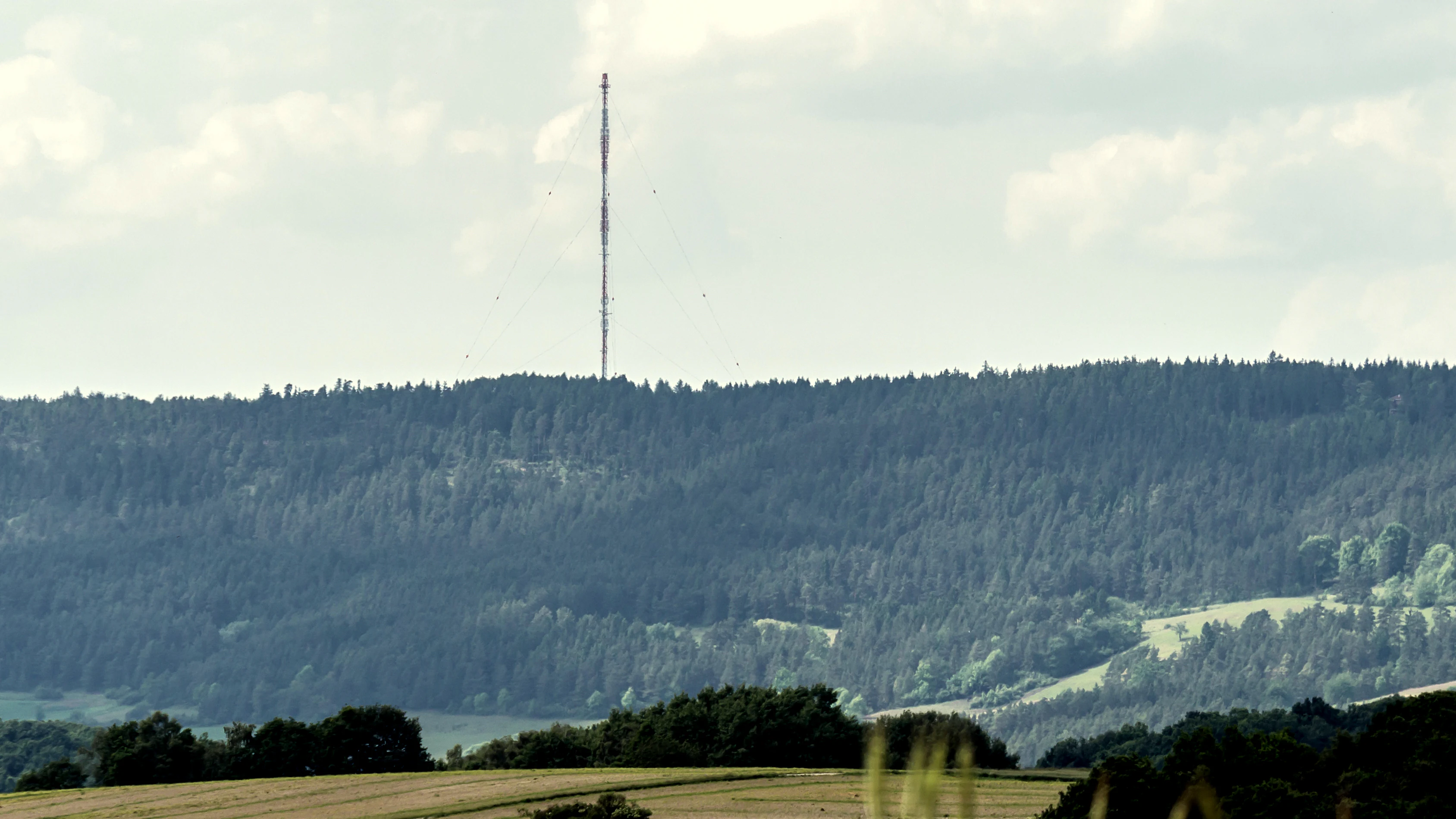
After the Deutsche Wiedervereinigung, the military function of the site ended. Parts of the extensive former NVA grounds were redeveloped into the Sendeanlage Remda broadcasting complex, now operated by Deutsche Funkturm (DFMG) with a 169-metre-high transmission mast, which has become the most visible structure on the hilltop. The legacy of the military period was thus partly converted into civilian infrastructure.
A second, unrelated chapter opened in 1999, when 264 hectares of the southern slopes were formally designated as a protected area under the European Fauna-Flora-Habitat (Richtlinie 92/43/EWG) framework. This designation recognised the existing natural value of the calcareous slopes rather than initiating restoration, and it remains the principal formal protection status linked to the hill today. Villages around the mountain such as Dienstedt, Kleinhettstedt, Oesteröda, Döllstedt, Nahwinden, Ehrenstein, Altremda, Remda and Breitenheerda continue to define the local cultural context of the area.
Großer Kalmberg landscape and geographic character
Großer Kalmberg belongs to the Ilm-Saale-Platte, a broad Muschelkalk plateau between the Ilm and Saale river valleys in central Thüringen. The hill itself is a gently rounded upland summit rather than a sharply peaked mountain, and it reaches 547.5 metres above NHN, the highest elevation of the plateau group outside the Zeugenberg of the Singener Berg. The surrounding terrain is a mosaic of similar low summits, dry valley systems and agricultural lowlands typical of the Thüringer Wald foreland.
The most distinctive feature of the landscape is its asymmetry. The northern side of the hill slopes gradually down toward the Ilm river valley, blending into fields, meadows and small villages. The southern side, by contrast, falls steeply into the Remdaer Graben, a narrow linear valley, where exposed limestone faces, thin soils and rocky ledges produce a markedly more rugged terrain. Two subsidiary points are recognised near the summit: the Kleine Kalm (511 metres) to the southwest of the main top, and the Kleine Kalmberg (467 metres) to the north, which together give the upper hill a slightly stepped character.
The plateau setting means that long-distance views from Großer Kalmberg are dominated by neighbouring limestone ridges, the broader Ilm-Saale-Platte to the east and west, and, on clear days, the closer outlines of the Thüringer Wald to the south. Despite its modest elevation, the hill therefore offers an unusually unobstructed panorama over the central Thuringian lowland.
Großer Kalmberg ecosystems, habitats, and plant life
Ecologically, Großer Kalmberg is defined by the Muschelkalk geology of the Ilm-Saale-Platte and by the contrast between forested summit slopes and exposed calcareous flanks. The hilltop and much of the upper slopes carry stands of pine (Kiefern), giving the summit its characteristic dark, coniferous cover and reinforcing the impression of a forested upland floating above the lower agricultural belt of the foreland.
The southern slopes, where thin limestone soils meet steep relief and the Remdaer Graben valley, support a much more varied set of habitats. Open, species-rich calcareous grasslands (Trockenrasen), ledges and rock-crevice communities (Felsfluren), small isolated mires (Moore), wet flushes (Feuchtbiotope) and patches of Pfeifengras (Molinia) grassland all occur within a relatively small area. This juxtaposition of dry and wet, open and wooded habitats on the same hill is the main reason the southern flank was recognised as a European FFH site.
In terms of vegetation zones, the hill spans the transition from dry, continental limestone grassland communities on the south face to denser pine-dominated forest cover on the upper slopes and gentler northern flanks. The result is a habitat mosaic that, despite the hill's modest size and altitude, supports a notably diverse flora for the region and provides important refuges for calcareous grassland specialists that have declined across much of central Europe.
Großer Kalmberg wildlife and species highlights
Wildlife information for Großer Kalmberg in the source material is closely tied to its status as a 264-hectare European FFH area on the southern slopes. The protected habitats support fauna typical of central European limestone landscapes, including species associated with dry calcareous grasslands, exposed rock and rock-crevice communities, and small mires and wet flushes. These habitat complexes are known elsewhere in the region to provide refuge for warmth-loving invertebrates, specialised grasshoppers and butterflies, reptiles using rocky outcrops, and breeding or foraging habitat for a range of bird species tied to open, semi-open and edge habitats rather than dense forest.
The presence of Molinia meadows and small peat-forming mires locally adds wetland-dependent invertebrates and amphibians to the suite of species supported, although the source page does not enumerate specific animals. Rather, the value of Großer Kalmberg for wildlife is best understood as the combination of calcareous grassland specialists on the south face and pine-forest species across the broader hill, set against the wider Ilm-Saale-Platte landscape.
Großer Kalmberg conservation status and protection priorities
Großer Kalmberg is not a national park or nature reserve in the formal German sense; its principal protection lies in European Union legislation. In 1999, roughly 264 hectares of its southern slopes were designated as an FFH-Gebiet (Fauna-Flora-Habitat site) under Directive 92/43/EWG, the European Habitats Directive. The designation was made specifically because the area combines open, species-rich limestone slopes with dry grassland, rocky outcrops and rock-crevice vegetation, alongside small mires, wet flushes, and Pfeifengras (Molinia) meadows.
This combination gave the southern flank of the hill a conservation significance well above its modest elevation and size, and the EU directive status formally anchors it within the Natura 2000 network of protected sites. The protection explicitly recognises the Schutzwürdigkeit (protection-worthiness) of the landscape, rather than designating the hill as a single contiguous nature reserve. Conservation management therefore focuses on maintaining the open character of the calcareous slopes and the integrity of the small mires against the pressures typical of central German low mountain landscapes, including shrub encroachment, abandonment of traditional land use and forest regeneration.
Großer Kalmberg cultural meaning and human context
The cultural context of Großer Kalmberg is shaped by the small villages of the Ilm-Saale-Platte that ring its slopes, including Dienstedt, Kleinhettstedt, Oesteröda, Döllstedt, Nahwinden, Ehrenstein, Altremda, Remda and Breitenheerda. These settlements belong to a long-established rural landscape between the Ilm and Saale valleys, with agriculture and forestry as the traditional land uses. The hill itself has been integrated into modern infrastructure through the Sender Remda transmission mast built after reunification on the former NVA military site, which has become a defining visual feature of the summit.
There is no specific documented indigenous or pre-modern cultural narrative linked to Großer Kalmberg in the source material. Its human significance is therefore primarily that of a regional landmark and a focal point of recent twentieth- and twenty-first-century land use, from DDR-era military deployment to post-1990 conversion to civilian broadcasting and partial conservation designation.
Top sights and standout views in Großer Kalmberg
Großer Kalmberg's strongest points of distinction are its position as the highest summit of the Ilm-Saale-Platte (excluding the Singener Berg), its clear asymmetry between the gentle northern descent toward the Ilm valley and the steep southern drop into the Remdaer Graben, and its mosaic of pine forest, calcareous dry grassland, rock outcrops and small mires. The hill also uniquely combines a twentieth-century military past, in the form of the former NVA Fla missile site, with a prominent piece of modern infrastructure in the 169-metre Sender Remda mast, and a 264-hectare European FFH site on its southern slopes.
Best time to visit Großer Kalmberg
The character of Großer Kalmberg changes with the seasons in ways typical of central German low mountain landscapes. Late spring and early summer are generally the most rewarding time to visit the calcareous slopes of the southern FFH area, when dry grasslands and rock-crevice vegetation are in flower and insect activity on the open limestone ground is at its peak. Summer offers warm conditions for walking the plateau trails and viewing the surrounding Ilm-Saale-Platte landscape in full foliage. Autumn brings colour to the pine forests on the summit and clearer views toward the Thüringer Wald. Winter typically brings a quieter, more subdued atmosphere, with possible snow cover on the upper slopes that emphasises the topographic contrast between the forested summit and the steeper southern face above the Remdaer Graben.