
Mori Atlas logo
Nature reserveIlmenauer Teichgebiet

Geographic boundaries and wetland terrain mapping in the heart of Thuringia

Ilmenauer Teichgebiet Nature Reserve: A Detailed Atlas of the Wetland Mosaic in Ilm-Kreis

Ilmenauer Teichgebiet serves as a sprawling nature reserve and vital wetland corridor located at the eastern fringe of Ilmenau, Thuringia. This interconnected system of six ponds, resting on a unique gypsum bedrock basin, forms a protected habitat that balances centuries of carp farming heritage with modern ecological conservation. The area provides a distinct open-water landscape that contrasts with the surrounding forested topography of the Ilm-Kreis district.

wetlandspond systemnature reservebirdwatchingmigratory birdswaterbirds
A flat vector-style illustration of a waterfall flowing down a cliff into a calm lake surrounded by forest and marshland.

Ilmenauer Teichgebiet

Nature reserve

Park overview

Structured park overview, official facts, and landscape profile for Ilmenauer Teichgebiet

Ilmenauer Teichgebiet park facts, protected area profile, and essential visitor context

Review the core facts for Ilmenauer Teichgebiet, including designation, size, terrain, visitor scale, habitats, and operating context in one park-focused overview.

About Ilmenauer Teichgebiet

The Ilmenauer Teichgebiet is a nature-protected wetland complex on the eastern edge of Ilmenau in the Thuringian district of the Ilm-Kreis. It consists of six ponds, the central Grosser Teich, the southwestern Neuhäuser Teich, the western Dixbixer Teich, the northwestern Brandenburger Teich, the northern Steinteich, and the northeastern Prinzessinnenloch, all fed by the small Rottenbach stream. The existence of the ponds is closely tied to the underlying geology: gypsum-rich ground in this part of the Ilm valley prevents the water from seeping away, allowing a chain of standing water bodies to be maintained in the middle of an otherwise hilly and climatically cool region. This geological quirk, combined with deliberate human management over more than six centuries, has produced one of the largest natural wetland landscapes in Thuringia.

Although the modern protection zone covers around 58 to 60 hectares, the broader pond landscape is often cited at about 100 hectares, reflecting an ecologically and culturally significant landscape rather than just a compact reserve. The area frames the eastern face of Ilmenau, lying between the railway station to the west and the campus of the Technical University of Ilmenau to the east. Today it functions simultaneously as a nature reserve with formal ecological objectives, a recreational landscape for residents and visitors, and a place where the town's working heritage of fish farming, public bathing, and outdoor gathering continues to be felt.

The ponds were first recorded in a 1351 charter between the Henneberg and Schwarzburg counts, when the ponds were part of the transferred town itself. Over the following centuries they were used to secure food in a region where geography and climate often limited agriculture, and carp farming became the dominant steady-state use of the water bodies. In 1891, public bathing was introduced at the Brandenburger Teich, then expanded to the Grosser Teich with separate men's and women's facilities, marking a turn toward recreational use. Bathing on the central pond continued into the 1960s, when pollution from the nearby university forced its closure, and a new outdoor pool was built in the Hammergrund area west of town.

Ecological recognition came in 1977, when the eastern part of the pond area was declared a Flächennaturdenkmal, or area natural monument, covering the Steinteich, Prinzessinnenloch, and the eastern part of the Grosser Teich. In 2002, the protection footprint was expanded to about 59.6 hectares and redesignated as a full Naturschutzgebiet, or nature reserve, bringing almost the entire pond complex under formal protection. Since then, the reserve has been used primarily by waterbirds, amphibians, reptiles, butterflies in the meadow zones, and migratory birds, while remaining an everyday recreation space for the people of Ilmenau.

Quick facts and research context for Ilmenauer Teichgebiet

Ilmenauer Teichgebiet is a Wetland and Habitat Species Management Area in the Ilm-Kreis district of Thuringia, Germany. The site covers approximately 58 hectares of designated protected area and roughly 100 hectares of total pond landscape extending across the eastern edge of Ilmenau. The ponds are fed by the Rottenbach stream and rest on a gypsum-rich substrate that keeps the water from draining.

The site has been protected in stages: the eastern portion was declared a natural monument in 1977, and in 2002 the area was expanded to about 59.6 hectares and redesignated as a full nature reserve. It is administered at the district level by the Ilm-Kreis. The pond system was first documented in 1351 in a Henneberg Schwarzburg charter, and carp farming has shaped its history for centuries, with the traditional autumn fish harvest still observed as a local festival.

Protection and recognition

Documented terrestrial protection metrics and official registry records

Ilmenauer Teichgebiet Protection Status and Designation History

Terrestrial protection status for Ilmenauer Teichgebiet was established in 2002 under verified conservation frameworks. Documented management parameters and international registry identifiers provide complete contextual data for this protected area.

Protection details

Protection scope
Terrestrial
Designated year
2002
Transboundary protection
No
WDPA ID
318586
Park context

Deeper park guide and search-rich context for Ilmenauer Teichgebiet

Ilmenauer Teichgebiet history, landscape, wildlife, and travel context

Explore Ilmenauer Teichgebiet through its history, landscape character, ecosystems, wildlife, conservation priorities, cultural context, and seasonal travel timing in a structured park guide built for atlas discovery and search intent.

Why Ilmenauer Teichgebiet stands out

Ilmenauer Teichgebiet is best known for being one of the largest natural wetland complexes in Thuringia, set as a string of six interconnected ponds at the eastern edge of the university town of Ilmenau. It is recognized as a protected habitat for waterbirds and amphibians, and as a resting place for migratory birds, all framed by an unusual geological setting where gypsum rock forms a natural basin that keeps the ponds filled year-round. The ponds are also known for their layered cultural history, from medieval fish ponds documented in a 1351 Henneberg charter, to public bathing at the Brandenburger Teich from 1891, to today serving as a recreational landscape for Ilmenau residents. The annual autumn Abfischen fish harvest, the bird observation hut built on the foundation of an old diving tower at the Grosser Teich, and the long-running fish farming tradition using carp as the dominant species are all signature elements of the area's identity.
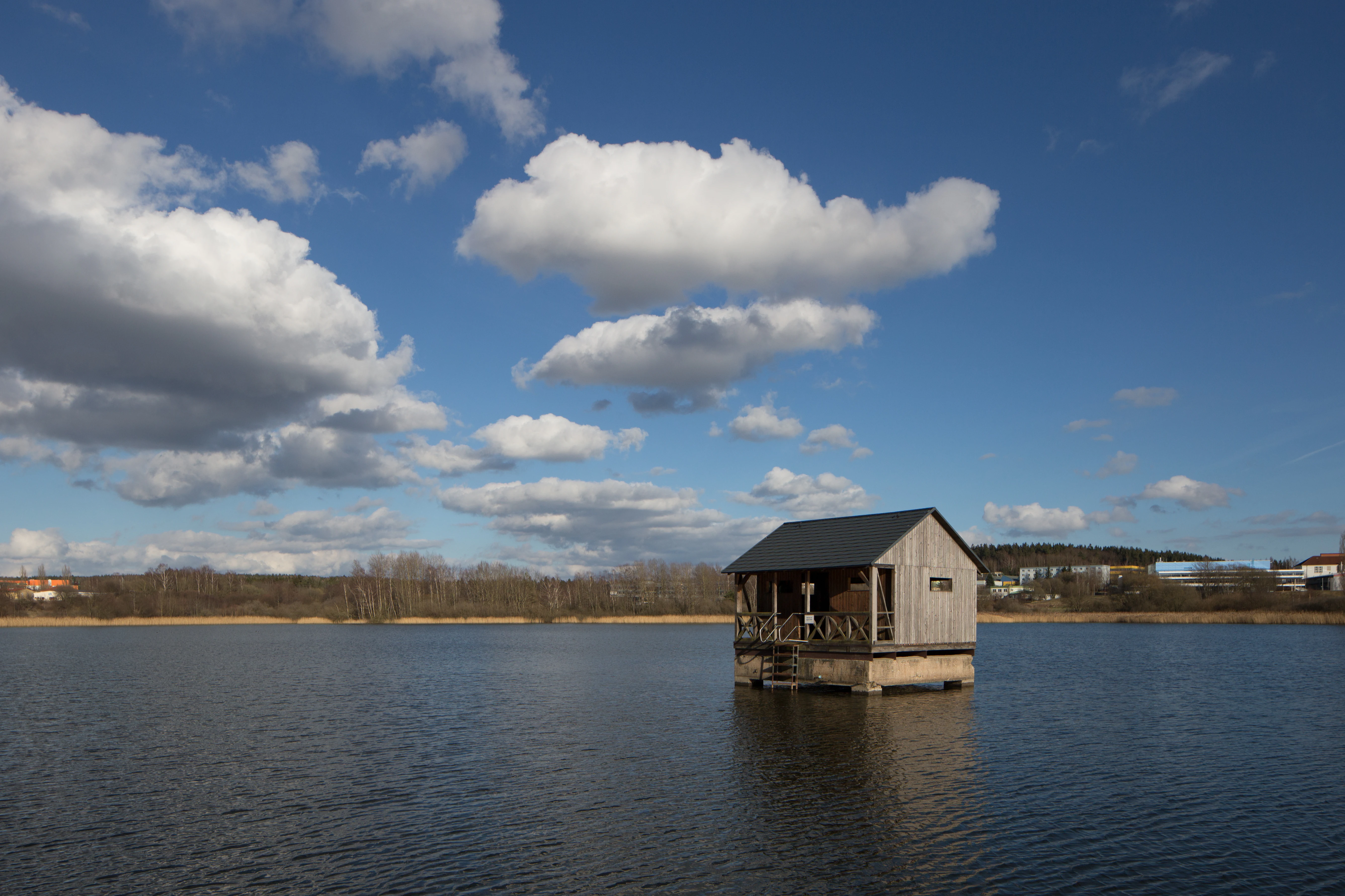
A small wooden stilt house sits in the middle of a calm pond under a bright blue sky with fluffy white clouds, with a distant treeline and buildings on the horizon.
A small wooden structure on the water at Grosser Teich in the Ilmenauer Teichgebiet.

Ilmenauer Teichgebiet history and protected-area timeline

The ponds of the Ilmenauer Teichgebiet were first documented on 5 September 1351, in a charter in which the counts of Henneberg transferred the town of Ilmenau to the counts of Schwarzburg. At that time the area already functioned as a chain of fish ponds, a role that took on particular weight in the Ilm valley, where harsh climate and difficult topography repeatedly produced local food shortages. For centuries afterwards, the ponds remained a working landscape, with carp as the dominant farmed species and a yearly harvest that is still marked in October and November by a traditional public festival.

In the late 19th century, the ponds took on a new role. On 31 May 1891 a public bathing facility opened at the Brandenburger Teich, beginning the ponds' life as a recreational resource. The first bathing site operated only until 1904, because a men's bath was opened at the Grosser Teich in 1900 and a women's bath there in 1904, concentrating public bathing on the larger pond. The Grosser Teich bath continued in operation into the 1960s, until pollution from the nearby Technical University of Ilmenau made the water unsafe and the site was closed. To replace it, a new outdoor pool with two concrete basins was built in the Hammergrund area west of town.

Formal ecological protection came in stages. In 1977, the eastern part of the pond complex, the Steinteich, the Prinzessinnenloch, and the eastern part of the Grosser Teich, was declared a Flächennaturdenkmal, recognizing its ecological value. In 2002, the protected footprint was expanded to around 59.6 hectares and the area was redesignated as a full Naturschutzgebiet, or nature reserve, administered by the Ilm-Kreis. This branding as a habitat and species management area in the IUCN framework reflects its modern function as a refuge for waterbirds, amphibians, reptiles, meadow butterflies, and migratory birds, even as the ponds retain their cultural role in the life of Ilmenau.

Ilmenauer Teichgebiet landscape and geographic character

The landscape is defined by a chain of six ponds embedded in the eastern edge of Ilmenau, opening into a wetland corridor between the railway station and the Technical University of Ilmenau. The ponds differ in size and exposure, but together they form a coherent wetland mosaic set within a broader valley context shaped by gypsum bedrock that retains water near the surface. The Grosser Teich anchors the system at the center, with the smaller Neuhäuser Teich, Dixbixer Teich, Brandenburger Teich, Steinteich, and Prinzessinnenloch arrayed around it.

The hydrology is fed by the small Rottenbach stream, which supplies the ponds with slow-moving, mineral-rich water that has historically supported extensive fishponds. Two historical ponds that once completed the chain, the Tonteich and the Kalkgräberteich, also known as Lehmteich, were drained in the 18th century and now no longer exist as open water. Where the old ponds once lay, the surrounding ground carries subtle signs of this layered past: the Schülerfreizeitzentrum near the Grosser Teich sits near the old Tonteich area, and meadow and field use continues around the modern remnant ponds.

Around the ponds, the ground transitions from open water into damp meadows, reed zones, and wooded fringes, providing a soft composition of low vegetation and water surfaces that is visually distinct from the surrounding Thuringian Forest terrain to the south. The ponds are large enough to anchor the landscape for visitors, with their reflective surfaces and slow-moving margins giving the area a calm, open character that contrasts with the steeper, forested slopes of the region.
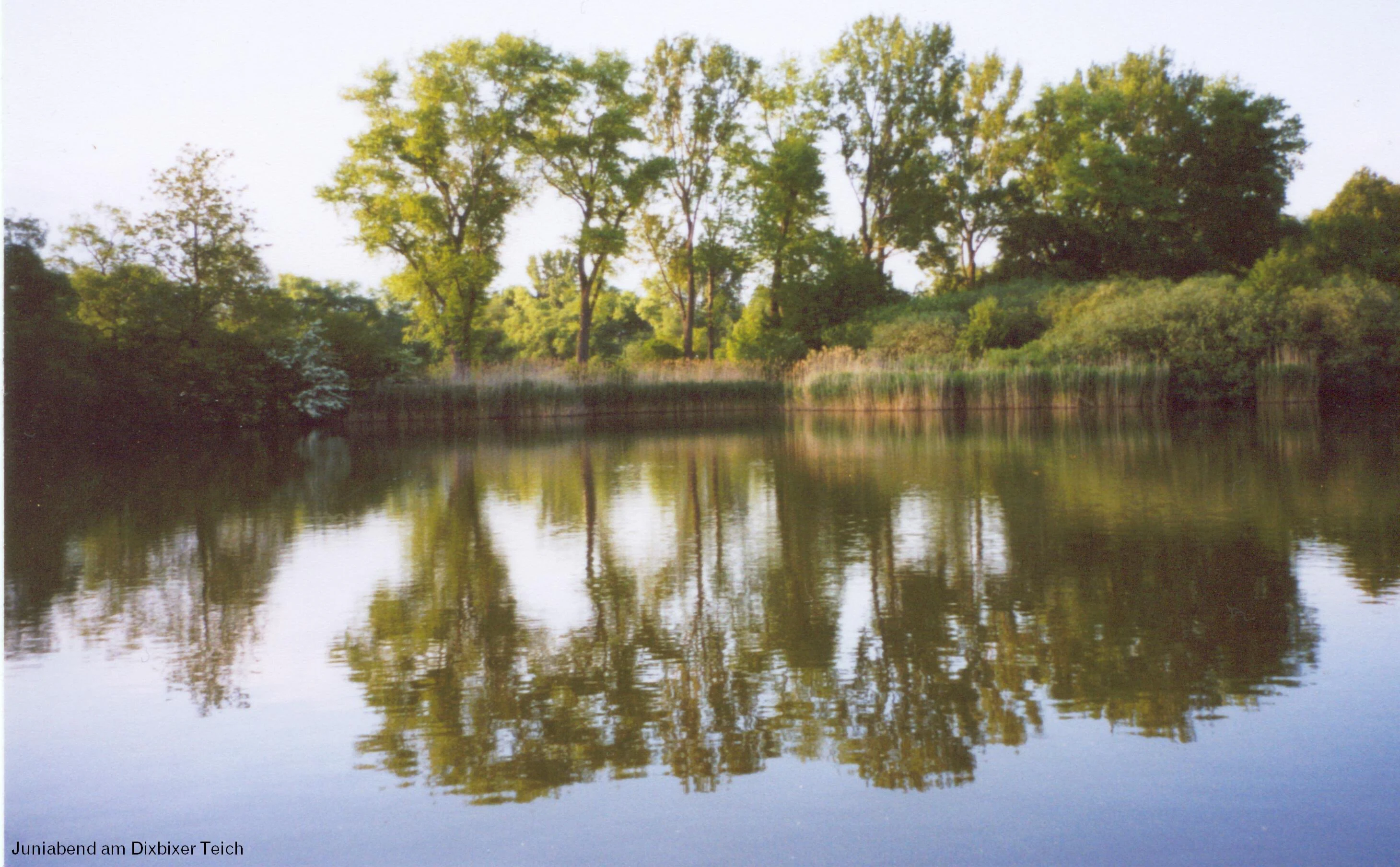
A still pond reflecting a line of trees on its bank, with tall reeds along the shoreline.
A serene view of Dixbixer Teich, one of the ponds within the Ilmenauer Teichgebiet nature reserve.

Ilmenauer Teichgebiet ecosystems, habitats, and plant life

The Ilmenauer Teichgebiet is a wetland complex whose ecological value rests on the combination of open water, vegetated margins, damp meadow areas, and transitional habitats around the ponds. The system functions as a habitat and species management area, designated both as a German nature reserve and in the IUCN Category IV framework, recognizing the importance of active conservation management rather than passive landscape protection alone.

The reserve supports several interacting ecological communities. The standing water of the ponds and their fringing reed and emergent vegetation zones provide breeding and resting conditions for waterbirds and habitat for amphibians and reptiles. The open meadows within the protected area are maintained for butterfly populations, particularly day-flying species that depend on the grassland structure around the ponds. This mix of aquatic, semi-aquatic, and meadow habitat, distributed across multiple interconnected basins, gives the reserve a layered ecological identity that is unusual in the otherwise forested and agricultural Thuringian landscape around Ilmenau.

Ilmenauer Teichgebiet wildlife and species highlights

Wildlife is the most prominent reason for the modern ecological significance of the Ilmenauer Teichgebiet. The ponds are valued first as a breeding area for waterbirds, providing nesting and feeding conditions within and along the margins of each of the main ponds. The reserve is also recognized as a stopover for migratory birds, with the chain of ponds offering resting habitat during seasonal passage through central Germany.

Beyond the birdlife, the reserve supports amphibians and reptiles that depend on the standing water and damp margins of the ponds. The open meadows around the wetland additionally sustain populations of butterflies, especially diurnal species whose presence is one of the explicit reasons cited for the protection of the grassland areas within the reserve. To support observation, a birdwatching hut has been built on the foundation of an old diving platform in the Grosser Teich, giving visitors direct access to view the birdlife without disturbing the ponds.

Ilmenauer Teichgebiet conservation status and protection priorities

The conservation significance of the Ilmenauer Teichgebiet is rooted in its long-running role as a wetland refuge within a region dominated by forest, slopes, and urban land. The gypsum-based basin that keeps the ponds filled has historically given the area a persistent character as a water-rich habitat in an otherwise dry and cool part of Thuringia.

This value was first formally recognized in 1977, when the eastern portion of the pond area was declared a Flächennaturdenkmal, giving it protected area status. In 2002, the protection was significantly expanded to about 59.6 hectares and the designation upgraded to a full Naturschutzgebiet, bringing nearly all of the remaining ponds and their surrounding meadows under coordinated conservation management. Under the IUCN system the reserve falls into Category IV, habitat and species management area, indicating that active management is part of its conservation approach. The conservation priorities emphasize protection of waterbird breeding habitat, amphibian and reptile populations, butterfly-friendly meadows, and migratory bird resting areas, while still accommodating the long-standing local uses of the ponds for fish farming and recreation.

Ilmenauer Teichgebiet cultural meaning and human context

The Ilmenauer Teichgebiet reflects a layered human relationship with a wet landscape in a region where geography and climate made food production unreliable. The ponds were documented as early as 1351, and over centuries they have been used to secure a local protein source through carp farming, with the autumn Abfischen fish harvest still celebrated as a local tradition.

In the late nineteenth century, the ponds also became a social resource for the townspeople. Public bathing at the Brandenburger Teich opened in 1891, and the Grosser Teich became the focal bathing pond with separate men's and women's facilities in the early 1900s. Bathing continued there into the 1960s, when university-related pollution forced it to close, after which outdoor swimming shifted to a new pool west of town. Today, the ponds continue this mixed identity: the Schülerfreizeitzentrum near the Grosser Teich hosts a small animal park and an independent school hostel, the wooded pond-side areas are used for evening gatherings such as grilling, boats can be rented, and a birdwatching hut invites quiet use of the same waters that have shaped life in Ilmenau for more than six centuries.

Top sights and standout views in Ilmenauer Teichgebiet

Ilmenauer Teichgebiet stands out as one of the largest natural wetland complexes in Thuringia, anchored by the central Grosser Teich and completed by five connected ponds of varying character.

Its identity rests on a combination of unusual geology, sustained carp farming, nineteenth century public bathing heritage, and modern ecological protection as a 1977 natural monument and 2002 nature reserve, together with active infrastructure such as a birdwatching hut and the local Schülerfreizeitzentrum that keeps the ponds woven into the everyday life of Ilmenau.

Best time to visit Ilmenauer Teichgebiet

The Ilmenauer Teichgebiet can be experienced throughout the warmer months, when the pond surfaces and meadow paths are most inviting for walking and observation. Spring is a particularly rewarding time for waterbirds and early amphibian activity around the edges of the ponds, while late summer and early autumn offer the richest birdwatching conditions, since migratory species use the chain of ponds as a resting place. The traditional autumn Abfischen festival in October and November also brings a distinctive cultural atmosphere to the area, reflecting centuries of carp-fishing heritage at the site.

Monthly climate preview

Examining representative monthly temperature ranges and precipitation averages for Ilm-Kreis

Ilmenauer Teichgebiet Climate Normals and Long-Term Weather Patterns

Long-term data records for Ilmenauer Teichgebiet trace measured monthly temperature shifts from sub-zero winter minimums to warm summer maximums alongside steady precipitation rates. Reviewing these representative point measurements establishes a baseline for understanding the wider ecological climate rhythm across the terrain.
Annual mean8 °C
-2 °C18 °C
Jan-2°
Feb-1°
Mar
Apr
May12°
Jun16°
Jul18°
Aug18°
Sep13°
Oct
Nov
Dec-1°
Warmest month
July

18 °C

Coolest month
January

-2.1 °C

Wettest month
July

2.7 mm/day

Driest month
April

1.4 mm/day

Park location guide

Geography guide, regional context, and park location map for Ilmenauer Teichgebiet

Ilmenauer Teichgebiet park geography, regions, and map view in Germany

Understand where Ilmenauer Teichgebiet sits in Germany through a broader geographic reading of the surrounding landscape, nearby location context, and its mapped position within the national park landscape.

How Ilmenauer Teichgebiet fits into Germany

Germany is a federal republic in Western and Central Europe with a population of over 83 million across sixteen constituent states. It is Europe's largest economy by nominal GDP and a major global exporter and importer. The capital is Berlin, and the country borders Denmark, Poland, Czech Republic, Austria, Switzerland, France, Luxembourg, Belgium, and the Netherlands.

Wider geography shaping Ilmenauer Teichgebiet in Germany

Germany is located in Western and Central Europe, spanning 357,022 km². It borders Denmark to the north, Poland and the Czech Republic to the east, Austria and Switzerland to the south, and France, Luxembourg, Belgium, and the Netherlands to the west. The country has coastlines on the Baltic Sea and North Sea to the north, with the Alps located in the southern region.

Map view of Ilmenauer Teichgebiet

Use this park location map to pinpoint Ilmenauer Teichgebiet in Germany, understand its exact geographic position, and read its mapped placement within the surrounding landscape more clearly.

Pigeon | © OpenStreetMap contributors

Location context for Ilmenauer Teichgebiet

Ilm-Kreis

Explore detailed imagery of the interconnected gypsum basin ponds, waterbird habitats, and wetland scenery.

Ilmenauer Teichgebiet Photos and Wetland Landscapes: Visual Guide to Protected Ponds

Examine high-resolution photographs illustrating the six interconnected ponds, damp meadows, and reed fringes defining the protected wetland corridor. Visual documentation reveals the distinct gypsum basin terrain, waterbird habitats, and calm environmental character unique to the Thuringian reserve.

A small wooden stilt house sits in the middle of a calm pond under a bright blue sky with fluffy white clouds, with a distant treeline and buildings on the horizon.

A peaceful lake set in a valley, surrounded by lush green trees and grasses, with rolling forested hills rising in the background under a clear sky.

A still pond reflecting a line of trees on its bank, with tall reeds along the shoreline.

Park atlas

Compare nearby protected landscapes, wetland corridors, and regional park geography

Parks Near Ilmenauer Teichgebiet and Other Protected Areas in the Region

Browsing other protected areas near Ilmenauer Teichgebiet reveals broader regional geography and connected wetland habitats across Thuringia. Comparing adjacent park ecosystems helps trace shifting terrain types, regional water basins, and local conservation networks.
Nature reserveThuringia
About 5.2 km away#1 closest

Northwest

Veronikaberg Nature Reserve: Protected Muschelkalk Ridge and Forest Landscapes in Thuringia

Geographic overview of the southern Reinsberge range.

Veronikaberg functions as a critical nature reserve at the southeastern edge of the Ohrdrufer Platte. The landscape is defined by its Muschelkalk geology, which supports a unique microclimate for beech and yew forests. This record details the park boundaries and the terrain transitions that characterize this significant conservation site in central Germany.

Area
1.161 km²
Established
1961
Relief
Mountain
Water
No major water
A horizontal watercolor painting depicting a landscape with soft, rolling hills in the background, a band of mixed forest with hints of autumn foliage in the midground, and a winding stream flowing through wetland grasses in the foreground.
Nature reserveThuringia
About 7.1 km away#2 closest

East

Pennewitzer Teiche und Unteres Wohlrosetal Nature Reserve: Thuringian Wetland Geography

A dense mosaic of historic ponds, moor woodlands, and framing stream valleys.

Located in Thuringia, this nature reserve is defined by an extraordinary density of aquatic habitats. The terrain features historic pond groups and flooded forest pits linked by brook valleys. This protected area serves as an essential example of the interplay between cultural pond construction and natural wetland ecosystems in central Germany.

Area
4.246 km²
Established
2004
IUCN
IV
Nature reserveThuringia
About 9.4 km away#3 closest

Northeast

Willinger Berg Nature Reserve: Exploring the Geography and Forested Terrain of the Ilm-Saale-Platte

A prominent muschelkalk limestone outlier in Thuringia

Willinger Berg stands out for its double-peaked silhouette and geological significance as a Zeugenberg. The 83.8 hectare nature reserve includes protected beech forests and karst features that define the slopes above the surrounding villages. This study traces its role as a regional landmark and its position within the complex watershed of the Ilm and Unstrut basins.

Area
0.838 km²
Relief
Mountain
Climate
Temperate
Scope
Terrestrial
Nature reserveThuringia
About 11 km away#4 closest

Northwest

Werra bis Treffurt mit Zuflüssen: Protected River and Floodplain Network in Thuringia

Mapping an extensive 191 kilometer Natura 2000 river corridor.

The Werra bis Treffurt mit Zuflüssen protected area serves as a vital ecological corridor in Thuringia. This site encompasses a complex mosaic of fast-flowing highland brooks, expansive floodplain meadows, inland salt sites, and rare dissolution lakes. Its geography bridges high-altitude source regions with lower river valleys, creating a distinctive landscape transect that supports essential freshwater habitats and rare aquatic species across the state.

Area
22.6 km²
Established
2008
IUCN
IV
Relief
Mixed relief
Nature reserveIlm-Kreis
About 13 km away#5 closest

North

Gottesholz Nature Reserve: Mapping the Protected Landscapes of Ilm-Kreis, Thuringia

A study of shell-limestone woodland geography

Gottesholz serves as an essential nature reserve in Ilm-Kreis, defined by its porous shell-limestone bedrock and rich, diverse vegetation. This detailed view covers the physical landscape, the strict forest reserve status, and the ecological markers that define this distinctive central German site.

Area
0.593 km²
Established
1961
IUCN
IV
Nature reserveThuringia
About 15 km away#6 closest

Northeast

Hohes Kreuz Nature Reserve: Mapping Forest Conservation in the Ilm District of Thuringia

A preserved oak-hornbeam landscape within the central German agricultural mosaic.

Hohes Kreuz is a protected nature reserve in Thuringia, Germany, renowned for preserving a residual oak-hornbeam forest on a Muschelkalk plateau. The site functions as an ecological refuge, supporting a wide variety of bird species and broadleaf vegetation while providing a striking contrast to the surrounding farmland of the Ilm district.

Area
0.105 km²
Established
1961
IUCN
IV
Relief
Upland
A soft watercolor illustration of a bog landscape featuring layers of green coniferous trees, a flat horizon, and distant, faint pink hills against a white background.
Nature reserveThuringia
About 17 km away#7 closest

West

Schützenbergmoor Nature Reserve: Highland Bog Landscape in Thuringia, Germany

Examining protected wetland terrain and bog ecology

Schützenbergmoor is an essential protected area for understanding highland raised bog ecosystems in the Thuringian Forest. This small, high-altitude site illustrates the intersection of peatland formation and cool, moist regional geography, offering a window into the specialized wetland terrain and microclimates that define this protected landscape in central Germany.

Area
0.052 km²
Established
1967
Relief
Upland
Climate
Temperate
Nature reserveThuringia
About 19 km away#8 closest

West

Saukopfmoor Nature Reserve: A Protected Raised Bog in Thuringia, Germany

Mapping peatland ecosystems within the Thuringian Forest

Saukopfmoor functions as a managed nature reserve in the Thuringian Forest, protecting valuable raised bog habitat that relies on specific high-elevation conditions. This site stands as a key example of peatland conservation in central Germany, revealing how stable mountain microclimates sustain specialized flora and complex hydrological processes across the regional landscape.

Area
0.346 km²
Established
1961
IUCN
IV
Climate
Temperate

Common questions about visiting, size, designation, and location context for Ilmenauer Teichgebiet

Ilmenauer Teichgebiet FAQs for park facts, access, geography, and protected area context

Find quick answers about Ilmenauer Teichgebiet, including protected-area facts, park geography, trail and visitor context, and how the park fits into its surrounding country and regional landscape.
MoriAtlas Explorer

Continue Your Protected Areas Search Across the Global Atlas

Deepen your exploration by continuing the structured search for national parks and protected areas worldwide. Utilize the comprehensive filtering capabilities to compare different conservation landscapes and refine your understanding of global park geography. Discover more about the distribution and characteristics of protected natural areas.

Global natural geography