
Mori Atlas logo
Nature reserveHeisterholz

Tracing the boundaries of one of the largest coherent oak woodland complexes in the region

Heisterholz Nature Reserve and the Protected Forest Landscapes of North Rhine-Westphalia

Heisterholz represents a significant protected forest complex located within the sandy lowlands of the Rahden-Diepenauer Geest. This nature reserve, anchored in North Rhine-Westphalia, preserves a rich mosaic of old-growth oak woodlands, spring-fed wetlands, and alder swamp forests that function as essential stepping-stone habitats across the northern landscape. The site serves as a vital geographic link in the broader forest belt stretching toward the Mindener and Schaumburger woodlands.

lowland forestold oak woodlandoak-hornbeam forestbirch-oak forestalder swamp forestspring-fed wetlands
A flat-style digital illustration showing a lush green forest landscape with a waterfall cascading from a cliff into a pool of water.

Heisterholz

Nature reserve

Park overview

Structured park overview, official facts, and landscape profile for Heisterholz

Heisterholz park facts, protected area profile, and essential visitor context

Review the core facts for Heisterholz, including designation, size, terrain, visitor scale, habitats, and operating context in one park-focused overview.

About Heisterholz

Heisterholz is one of the most significant forested areas in the northern Minden-Lübbecke region, combining the character of a traditional state-owned woodland with formal conservation protection at both federal state and European levels. Located within the city area of Petershagen, the forest is dominated by oak-dominated communities growing on the sandy substrates of the Rahden-Diepenauer Geest, a natural region shaped by glacial and periglacial processes.

Despite the long history of forestry use in the region, much of the woodland has retained stands of old trees, giving Heisterholz disproportionate ecological value in a landscape otherwise dominated by agriculture. The presence of mature oaks, hornbeams, birches, and alders supports a rich community of fungi, lichens, and invertebrates, while the mosaic of wet hollows, springs, and small stream valleys provides additional habitat diversity.

The nature reserve Heisterholz was designated to safeguard these old oak forests and their associated ecological communities, including alder swamp forest, ash-alder woodland, reed beds, and sedge marshes. The site also plays a strategic role as a stepping-stone biotope (Trittsteinbiotop), helping connect the local woodland network with the larger Mindener Wald and, beyond it, with the forest belt that extends into the Schaumburger Wald.

Quick facts and research context for Heisterholz

Heisterholz lies south-west of Petershagen town center and is bounded to the east by the B 61 federal road and to the north by the L 770 and L 772 state roads. The wider woodland complex spans roughly 880 hectares, while the formally protected nature reserve covers about 403 hectares and is catalogued under the code MI-064.

It is registered as an FFH area with the reference number 3619-301 and is classified as an area of statewide importance within the regional biotope network of North Rhine-Westphalia. The forest is owned by the state of North Rhine-Westphalia and is recognised as a stepping-stone habitat linking to the larger Mindener Wald.

Protection and recognition

Documented terrestrial protection scope and international designation records

Heisterholz Protection Status and Official Natura 2000 Recognition Data

Terrestrial protection records for Heisterholz compile documented designation details and official Natura 2000 recognition sources. Conservation framework data details the established management scope and international registry listings associated with this protected landscape.

International recognition

Protection details

Protection scope
Terrestrial
Transboundary protection
No
Core area
4.03 km²
Park context

Deeper park guide and search-rich context for Heisterholz

Heisterholz history, landscape, wildlife, and travel context

Explore Heisterholz through its history, landscape character, ecosystems, wildlife, conservation priorities, cultural context, and seasonal travel timing in a structured park guide built for atlas discovery and search intent.

Why Heisterholz stands out

Heisterholz is best known for its extensive old-growth oak forests growing on sandy soils, including pedunculate oak woodlands, oak-hornbeam stands, and birch-oak communities that are characteristic of the Rahden-Diepenauer Geest. Its near-natural spring zones, stream valleys, and alder swamp fragments add to its ecological importance, supporting specialist species of conservation concern. The reserve is also notable for its woodland bird community, particularly woodpecker species, and for its role within a larger forest belt that links forested areas across the northern Minden-Lübbecker Land and into the Schaumburger Wald.
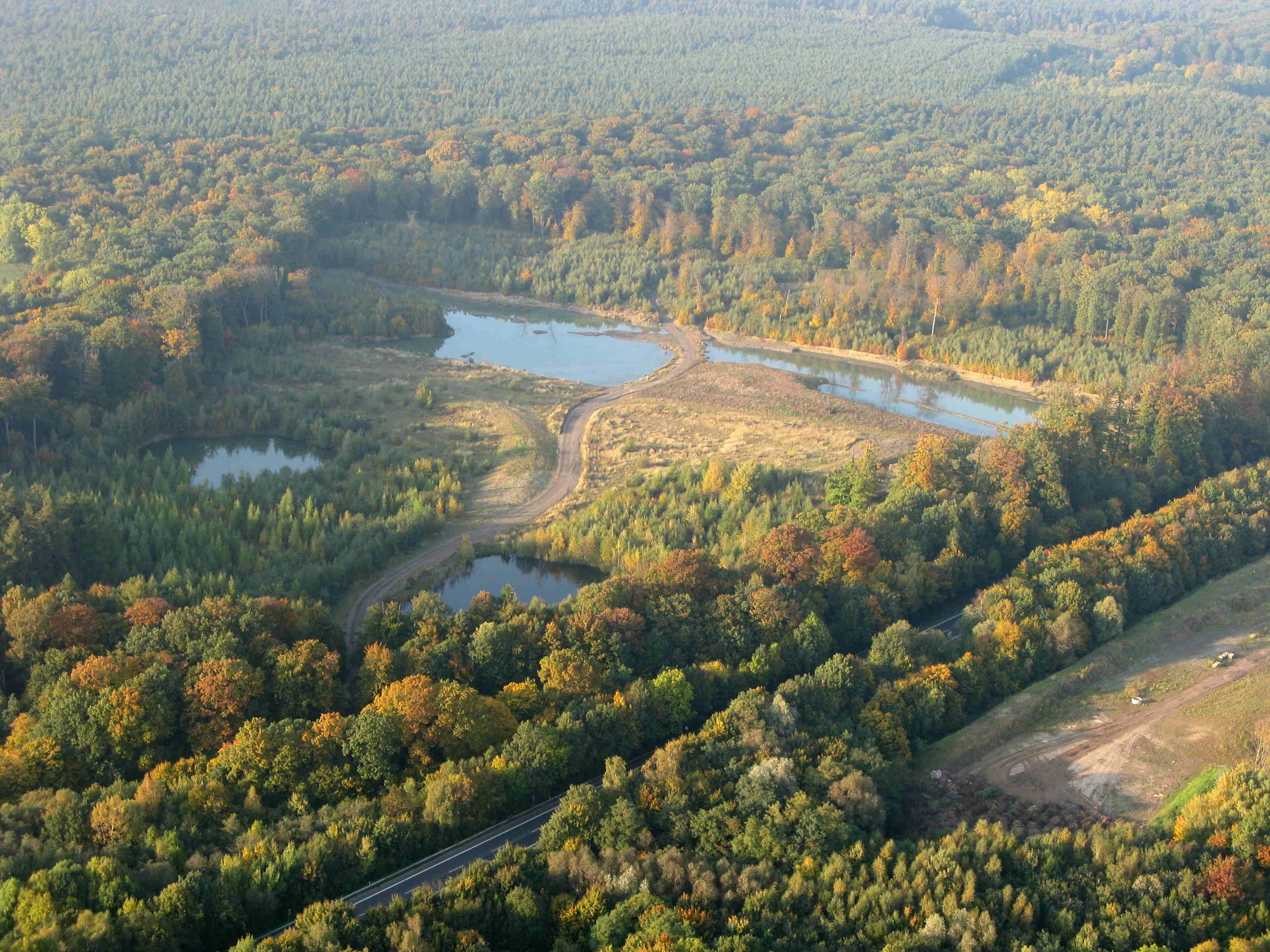
Aerial view of a densely wooded forest area containing multiple small ponds and a paved road cutting through the trees.
An aerial view showing the intersection of the Heisterholz forest landscape and nearby road infrastructure.

Heisterholz history and protected-area timeline

The forest draws its name from a long-standing regional toponym and once lent its name to a former local clay industry, Tonindustrie Heisterholz, which produced bricks, roof tiles, and notably the floor mosaic of the Kaiser-Wilhelm-Gedächtniskirche in Berlin.

As a formal nature reserve, Heisterholz was designated to protect old oak woodland on sandy soils and associated wetland habitats from further loss. Its inclusion in the European FFH network reflects its recognition as a regionally important habitat site for old-growth forests and species-rich wet woodland communities. The forest remains owned by the state of North Rhine-Westphalia and is integrated into state-level planning documents as an area of statewide significance within the regional biotope network (Biotopverbund).

Heisterholz landscape and geographic character

Heisterholz occupies a gently undulating position within the Rahden-Diepenauer Geest, a sandy lowland landscape typical of the North German plain. The terrain is shaped by glacial and postglacial sand deposition, creating acidic, well-drained soils that favour oak-dominated woodland rather than beech forest.

Wet features interrupt the otherwise dry woodland matrix, with spring zones, small brook valleys, and seepage areas producing localised mires, reed beds, and sedge-dominated wetland patches. These wet hollows contrast with the drier, higher-lying forest stands and create the structural mosaic that defines the area's landscape character. Old field edges and forest margins along the B 61 and the L 770 and L 772 roads mark the modern boundaries of the woodland.
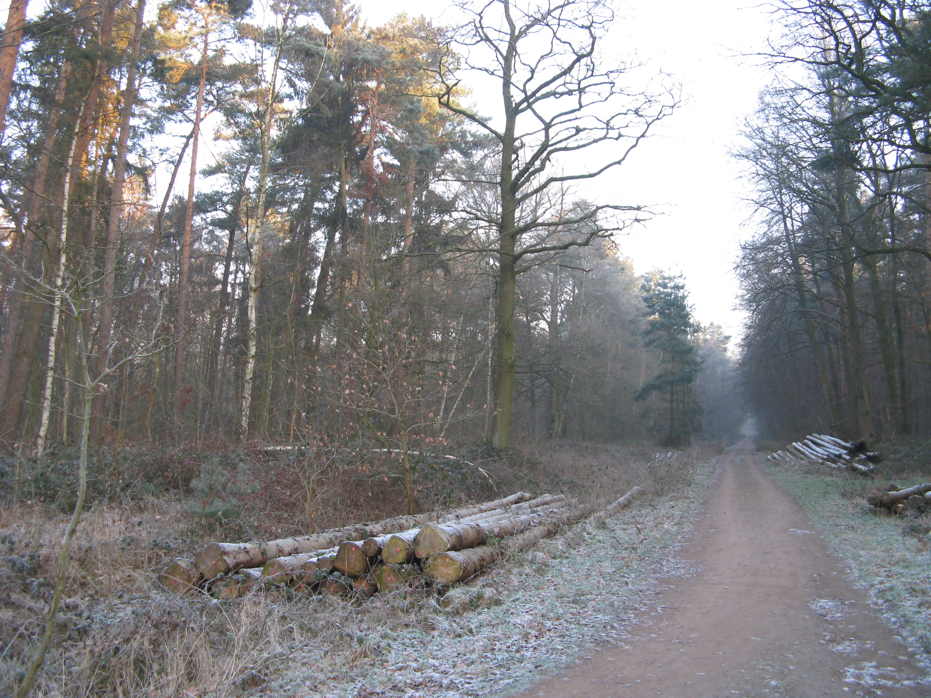
A dirt forest road winds through dense deciduous and coniferous trees on a cold morning with frost on the ground and stacks of cut logs in the foreground.
A dirt path leads through the Heisterholz forest, where piles of timber sit along the edge during a frost-touched morning.

Heisterholz ecosystems, habitats, and plant life

Ecologically, Heisterholz is defined by a small-scale mosaic of dry and wet forest habitats typical of sandy lowland geest landscapes. The core habitats include old oak forests on sand, oak-hornbeam communities, and birch-oak woodland, all of which carry a substantial complement of veteran trees.

Wet habitats within and at the margins of the forest include alder swamp forest (Erlenbruchwald), ash-alder forests along springs and brooks, reed beds (Röhrichte), and sedge marshes (Seggenriede). Natural spring areas (Quellbereiche) and small stream valleys (Bachniederungen) sustain these wet communities and host moisture-loving plants and invertebrates. Together with adjacent protected sites such as the Nordholz and Kohbrink reserves across the municipal border in Minden, Heisterholz forms part of a larger connected network of woodland and wet habitats.

Heisterholz wildlife and species highlights

The woodland provides habitat for species closely tied to old oak trees and structurally rich, semi-open forest conditions. Bird species of conservation interest in the reserve include the Middle Spotted Woodpecker (Mittelspecht) and the Black Woodpecker (Schwarzspecht), both of which depend on mature trees and veteran wood for nesting and feeding.

The combination of spring-fed wetlands, alder swamp, and forest pools also makes the area suitable for amphibians, notably the Great Crested Newt (Kammmolch), which is identified as a target species for the site's conservation management. Invertebrate communities associated with deadwood-rich oak forest, wet woodland, and small seepage lines are an important, though less visible, component of the reserve's wildlife value.

Heisterholz conservation status and protection priorities

Heisterholz holds a layered conservation designation: a German Naturschutzgebiet under state law, designated to protect old oak woodlands, oak-hornbeam stands, birch-oak communities, and associated wet forest habitats; and a European Natura 2000 FFH site under the EU Habitats Directive for habitat types including old acidophilous oak forests and wet woodland communities.

The reserve is identified in both the Landesentwicklungsplan and the Gebietsentwicklungsplan of North Rhine-Westphalia as an area of statewide importance within the regional biotope network. As a stepping-stone biotope linked to the larger Mindener Wald, it helps maintain ecological connectivity across a 31-kilometre forest belt running through the northern Minden-Lübbecker Land and into the Schaumburger Wald. The fact that the forest is owned by the state of North Rhine-Westphalia supports long-term, large-scale forest management oriented toward habitat conservation rather than short-term commercial exploitation.

Heisterholz cultural meaning and human context

Beyond its ecological role, Heisterholz carries a regional cultural footprint through the historical Tonindustrie Heisterholz, a local clay products industry named after the forest and known for producing building materials such as bricks and roof tiles. Its products, including floor mosaics, reached far beyond the local area.

Top sights and standout views in Heisterholz

Heisterholz stands out as one of the largest closed forest complexes within the Rahden-Diepenauer Geest, with a notable share of old trees and a rich internal mosaic of dry oak woodland and wet, spring-fed habitats such as alder swamp forest, ash-alder corridors, reed beds, and sedge marshes.

Its layered protected status (state nature reserve plus FFH site), its ownership by the state of North Rhine-Westphalia, and its function as a stepping-stone biotope toward the Mindener Wald make it a key structural element in the long forest belt that crosses the northern Minden-Lübbecker Land.

Best time to visit Heisterholz

As a lowland oak forest in a temperate climate, Heisterholz is most enjoyable in late spring and early summer, when foliage is fully out, woodland birds such as woodpeckers are most vocal, and the wet woodland habitats along springs and brook valleys are at their most lush. Autumn brings rich fungus and lichen displays in the old oak stands, while winter offers quieter conditions and clearer views along the forest margins and into the wet hollows.


Monthly climate preview

Long-term monthly weather data and temperature ranges recorded at representative coordinates

Heisterholz Climate Normals, Average Temperature and Precipitation Patterns

Recorded measurements for Heisterholz outline a measured annual temperature rhythm alongside consistent daily precipitation distributions across the coordinate point. Examining the complete monthly climate profile reveals detailed temperature fluctuations and precipitation averages across the entire twelve-month span.
Annual mean9 °C
1 °C18 °C
Jan
Feb
Mar
Apr
May13°
Jun16°
Jul18°
Aug18°
Sep14°
Oct10°
Nov
Dec
Warmest month
July

18.5 °C

Coolest month
January

0.9 °C

Wettest month
July

2.3 mm/day

Driest month
April

1.4 mm/day

Park location guide

Geography guide, regional context, and park location map for Heisterholz

Heisterholz park geography, regions, and map view in Germany

Understand where Heisterholz sits in Germany through a broader geographic reading of the surrounding landscape, nearby location context, and its mapped position within the national park landscape.

How Heisterholz fits into Germany

Germany is a federal republic in Western and Central Europe with a population of over 83 million across sixteen constituent states. It is Europe's largest economy by nominal GDP and a major global exporter and importer. The capital is Berlin, and the country borders Denmark, Poland, Czech Republic, Austria, Switzerland, France, Luxembourg, Belgium, and the Netherlands.

Wider geography shaping Heisterholz in Germany

Germany is located in Western and Central Europe, spanning 357,022 km². It borders Denmark to the north, Poland and the Czech Republic to the east, Austria and Switzerland to the south, and France, Luxembourg, Belgium, and the Netherlands to the west. The country has coastlines on the Baltic Sea and North Sea to the north, with the Alps located in the southern region.

Map view of Heisterholz

Use this park location map to pinpoint Heisterholz in Germany, understand its exact geographic position, and read its mapped placement within the surrounding landscape more clearly.

Pigeon | © OpenStreetMap contributors

Location context for Heisterholz

North Rhine-Westphalia

Examine the habitats, old oak stands, and sandy terrain defining the reserve.

Heisterholz Photos and Landscape Scenery: Visualizing the Lowland Forest

Visual records document the old oak woodlands, birch stands, and spring-fed wetlands characterizing the protected Heisterholz environment. Photographic views illustrate the sandy terrain, alder swamp fragments, and forest mosaics spanning the North German plain.

Aerial view of a densely wooded forest area containing multiple small ponds and a paved road cutting through the trees.

A wide view of a forest edge at the border of an open, frost-covered field in late autumn or winter.

A dirt forest road winds through dense deciduous and coniferous trees on a cold morning with frost on the ground and stacks of cut logs in the foreground.

Park atlas

Compare adjacent woodland reserves and connected forest belts across the surrounding region

Explore Parks Near Heisterholz And Related Protected Landscapes

Browse other protected areas and lowland forest reserves located close to Heisterholz in North Rhine-Westphalia. Comparing these neighboring woodland habitats reveals the wider regional distribution of sandy geest ecosystems and connected wildlife corridors.
Watercolor illustration of a peaceful lakeside scene at Lahder Marsch, featuring birch trees, marshy vegetation, and a calm water surface.
Nature reserveKreis Minden-Lübbecke
About 2.6 km away#1 closest

East

Lahder Marsch Nature Reserve: Protected Wetland Mosaic in Kreis Minden-Lübbecke

A mapped sanctuary for migratory birds within the Weser floodplain.

Lahder Marsch is a designated nature reserve located in the Weser river valley, forming a chain of flooded gravel pits that sustain diverse avian populations. This protected landscape, characterized by open water, islands, and dense reed fringes, serves as a crucial habitat within the larger Weseraue Natura 2000 network, illustrating the geographic importance of restored extraction sites in lowland Germany.

Area
0.19 km²
Water
Major water bodies
Nature reserveNorth Rhine-Westphalia
5.5 km away#2 closest

West

Mindenerwald Protected Nature Reserve: Geography, Boundaries, and Forest Terrain

A vital deciduous woodland complex in northern North Rhine-Westphalia.

The Mindenerwald nature reserve represents a substantial forest tract characterized by sandy-soil oak woodlands and diverse ash-alder wetlands. This protected landscape serves as a critical node for habitat connectivity, hosting a complex mosaic of spring-fed marshes and mature trees that support important bird and bat species within the broader Minden-Lübbecke district.

Area
8 km²
Relief
Lowland
Scope
Terrestrial
Water
Minor water
Nature reserveNordrhein-Westfalen
About 7 km away#3 closest

Northeast

Weseraue Nature Reserve and Weser River Floodplain Geographic Overview

Protected wetland landscapes in North Rhine-Westphalia

The Weseraue landscape encompasses 25 kilometers of the Weser river corridor, characterized by its diverse mix of dammed sections, natural flow channels, and seasonal wet grasslands. As a cornerstone of the Natura 2000 network, it provides essential habitat for breeding and migratory species, serving as a primary refuge within the North Rhine-Westphalia floodplain geography.

Area
27.438 km²
Established
1983
Relief
Lowland
Scope
Terrestrial
Nature reserveNorth Rhine-Westphalia
About 12 km away#4 closest

South

Wittekindsberg Nature Reserve: Mapping Protected Forests and Jurassic Cliffs in Germany

A conservation-focused geographic analysis of the Wiehengebirge ridge

Wittekindsberg Nature Reserve represents a key protected landscape in northeastern North Rhine-Westphalia. Spanning the crest of the Wiehengebirge, the area is characterized by a mosaic of beech-dominated forests and Jurassic-age geological features. This atlas entry provides essential context on the reserve's topography, cliff-face habitats, and its role as a representative ecological site within the larger Natura 2000 network of the region.

Area
1.143 km²
Established
1990
IUCN
IV
Relief
Mountain
Nature reserveLower Saxony
19 km away#5 closest

Northeast

Steinhuder Meer mit Randbereichen: Protected Nature Reserve and Wetland Geography

Lowland lake, fen meadows, and bog ecosystems in Lower Saxony

Steinhuder Meer mit Randbereichen stands as a primary conservation site in northwestern Germany. The protected landscape combines a vast, shallow lowland lake with extensive reed belts and peatland remnants, creating a complex wetland gradient that defines the regional geography of the Weser-Aller lowlands.

Area
53.71 km²
Established
2004
A wide watercolor illustration showing a misty landscape with soft purple mountains in the distance and pink and green grasses in the foreground against a white background.
Nature reserveGermany
About 20 km away#6 closest

Northwest

Steinbrinker-Ströhener Masch: Nature Reserve and Wetland Protected Area in Lower Saxony

Mapping the fen peat grasslands and moorland buffers of Germany.

Steinbrinker-Ströhener Masch is an essential protected site in northwestern Germany, characterized by low-lying fen peat soils and expansive wet grasslands. Functioning as a key link within the Diepholzer Moorniederung, the area preserves critical habitat for meadow-breeding birds, shaped by seasonal waterlogging and traditional low-intensity land management techniques.

Area
3.25 km²
Established
1991
Relief
Lowland
Climate
Temperate
A soft watercolor illustration depicting a line of trees and greenery along a shoreline with rolling hills in the background.
Nature reserveKreis Lippe
About 20 km away#7 closest

South

Naturschutzgebiet Abgrabung Stemmen: Protected Landscape and Regional Geography in Kreis Lippe

Post-mining habitat restoration in North Rhine-Westphalia

Gain insights into the geography and conservation status of Naturschutzgebiet Abgrabung Stemmen. This 20-hectare nature reserve in Kreis Lippe showcases the development of ruderal grasslands, willow pioneer woodland, and wetland ecosystems across a reclaimed industrial site.

Area
0.2 km²
Established
1995
A horizontal watercolor illustration featuring a stylized forest with shades of green and yellow trees against a backdrop of soft, faint hills.
Nature reserveNorth Rhine-Westphalia
About 21 km away#8 closest

West

Sonnenwinkel Nature Reserve: Protected Landscape and Forest Ecology in North Rhine-Westphalia

Calcareous beech forest and seasonal woodland habitats

Sonnenwinkel is a dedicated nature reserve near Lübbecke, North Rhine-Westphalia, providing a critical refugium for calcareous beech forest. The site exhibits distinct ecological boundaries defined by the Wiehengebirge foothills and remains a significant example of protected lowland forest habitat in Germany.

Area
0.047 km²
Relief
Mountain
Climate
Temperate
Access
Easy access

Common questions about visiting, size, designation, and location context for Heisterholz

Heisterholz FAQs for park facts, access, geography, and protected area context

Find quick answers about Heisterholz, including protected-area facts, park geography, trail and visitor context, and how the park fits into its surrounding country and regional landscape.
MoriAtlas Explorer

Continue Your Protected Areas Search Across the Global Atlas

Deepen your exploration by continuing the structured search for national parks and protected areas worldwide. Utilize the comprehensive filtering capabilities to compare different conservation landscapes and refine your understanding of global park geography. Discover more about the distribution and characteristics of protected natural areas.

Global natural geography