
Mori Atlas logo
Nature reserveSonnenwinkel

Examining the ecological boundaries and landscape features of this sheltered woodland fragment

Sonnenwinkel Nature Reserve: A Protected Calcareous Beech Forest in North Rhine-Westphalia

(Naturschutzgebiet Sonnenwinkel)

Sonnenwinkel represents a vital protected nature reserve on the northern fringe of the Wiehengebirge in North Rhine-Westphalia. This area preserves a rare calcareous beech forest habitat, characterized by deep, nutrient-rich soils and a diverse undergrowth of wild garlic, woodruff, and cowslip. By analyzing the terrain and boundaries of this site, one gains insight into the fragmented woodland ecosystems that define the transition between the North German Plain and central mountain ranges.

nature reservedeciduous forestbeech forestcalcareous woodlandwild garlicwoodland herbs
A flat-style graphic illustration depicting a valley with tall cliffs, two tiered waterfalls in the distance, a meandering stream in the foreground, and pine trees under a sky with light clouds.

Sonnenwinkel

Nature reserve

Park overview

Structured park overview, official facts, and landscape profile for Sonnenwinkel

Sonnenwinkel park facts, protected area profile, and essential visitor context

Review the core facts for Sonnenwinkel, including designation, size, terrain, visitor scale, habitats, and operating context in one park-focused overview.

About Sonnenwinkel

Sonnenwinkel is a compact, ecologically focused nature reserve set into the northern slopes of the Wiehengebirge, just outside the town center of Lübbecke in eastern North Rhine-Westphalia. Although small, the site carries significant ecological value because it preserves one of the better-developed examples of calcareous beech forest in this part of the country, with mature beech stands accompanied by maple and oak and a richly structured understory.

The reserve occupies a transitional zone between the residential and infrastructural edges of Lübbecke, including direct adjacency to the local hospital, and the natural wooded slopes of the Wiehen Hills. This positioning gives the site both a conservation function and a local amenity presence, as residents and visitors walk the forest paths in spring. Administratively registered as MI-030, the area is managed as a formal German nature reserve (Naturschutzgebiet), the country's strictest standard of area-based nature protection, which carries legal restrictions on activities that could harm the protected communities.

Ecologically, Sonnenwinkel's significance lies in its plant communities. The forest floor in spring is dominated by extensive stands of wild garlic, which form dense green carpets across much of the area. This phenomenon is so characteristic that residents have traditionally harvested the leaves for culinary use, even though doing so and leaving the marked paths are technically regulatory offenses. Beyond the wild garlic, the herb layer includes cowslip, hollow corydalis, black ramping-fumitory, woodruff, lungwort, and mercury, a combination that marks the area as a credible representative of the threatened calcareous beech forest habitat type.

Quick facts and research context for Sonnenwinkel

Sonnenwinkel is a designated nature reserve of approximately 4.7 hectares, classified under the official code MI-030 and administered within the Lübbecke area of the Minden-Lübbecke district. It lies at the northern foothills of the Wiehengebirge and borders on the Lübbecke hospital grounds. Its core ecological character is defined by calcareous beech forest with a notably rich herb layer, and its official protection rationale centers on the rarity and ecological quality of this habitat complex, including its role as a refuge for threatened flora and fauna.

Protection and recognition

Examine the recorded designation history and management framework of Sonnenwinkel.

Sonnenwinkel Protection Status and Documented Terrestrial Conservation Scope

Sonnenwinkel holds documented terrestrial protection status within its regional conservation framework. Recorded management scope and international recognition records provide factual context for this protected natural area.

Protection details

Protection scope
Terrestrial
Transboundary protection
No
Park context

Deeper park guide and search-rich context for Sonnenwinkel

Sonnenwinkel history, landscape, wildlife, and travel context

Explore Sonnenwinkel through its history, landscape character, ecosystems, wildlife, conservation priorities, cultural context, and seasonal travel timing in a structured park guide built for atlas discovery and search intent.

Why Sonnenwinkel stands out

Sonnenwinkel is best known for its spectacular springtime display of wild garlic, whose broad leaves blanket almost the entire forest floor from early spring through early summer. The reserve also represents a well-preserved fragment of the calcareous beech forest (Kalkbuchenwald) habitat that has become increasingly rare across Germany's central low mountain ranges, with a diverse spring flora including cowslip, hollow corydalis, black ramping-fumitory, woodruff, lungwort, and mercury.
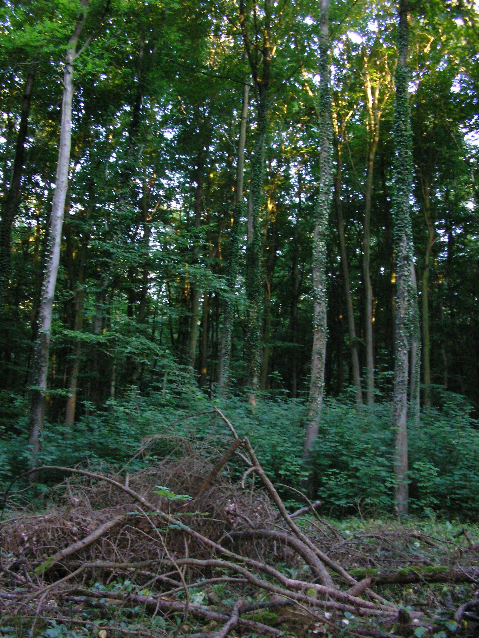
A view inside a dense, green deciduous forest with tall tree trunks covered in climbing ivy, and scattered deadwood in the foreground.
A dense forest interior with tall, ivy-clad deciduous trees in the Sonnenwinkel nature reserve.

Sonnenwinkel landscape and geographic character

Sonnenwinkel occupies a position on the northern edge of the Wiehengebirge, a low range of hills that forms part of the boundary between the North German Plain and the slightly elevated landscapes of central Germany. Although the hills here are not high, they create the topographic and climatic gradients that support calcareous beech woodland rather than the more acidic, often conifer-dominated forests found on sandstone further north.

The reserve itself is a typical small wooded valley and slope landscape: mature deciduous trees, a deep and seasonally lush herb layer, and shaded, sheltered conditions where soil moisture and leaf litter build up over centuries. The proximity to the Lübbecke hospital grounds creates a clear ecological buffer between the built environment and the broader Wiehen Hills landscape, which extends southward through a chain of protected areas within the former Lübbecke district.
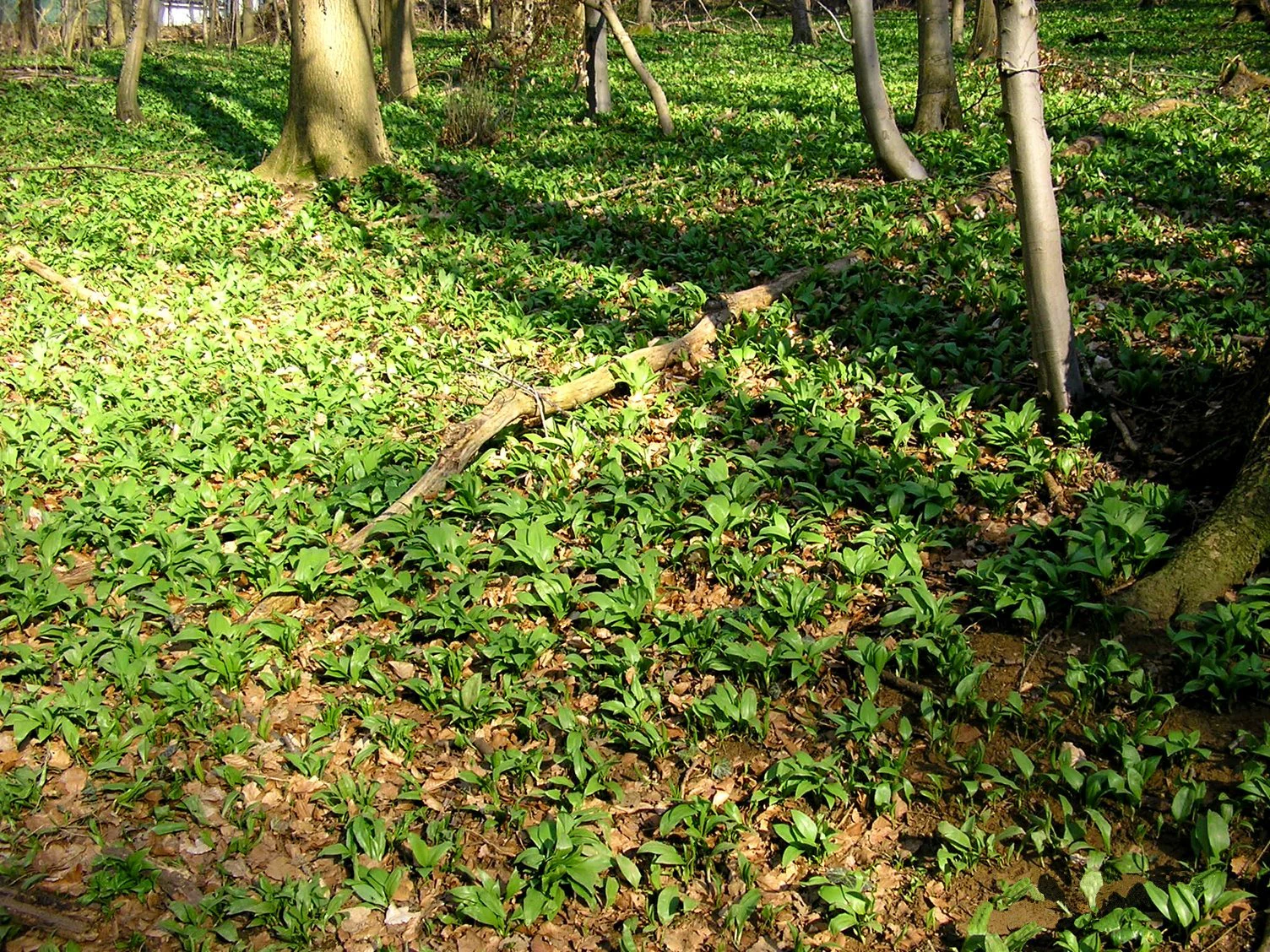
A forest floor covered in green wild garlic plants with scattered fallen leaves, set among several mature tree trunks.
A dense ground cover of wild garlic in the beech forests of Sonnenwinkel nature reserve.

Sonnenwinkel ecosystems, habitats, and plant life

The vegetation of Sonnenwinkel centers on calcareous beech forest, a habitat type of considerable conservation interest across central Europe because of its long decline under historical forestry pressure. The canopy is dominated by beech, with subordinate maple and oak, producing the semi-open light conditions that allow a diverse spring woodland herb layer to thrive.

The herb layer is the reserve's signature feature. Wild garlic is the dominant spring species, often forming continuous carpets across the forest floor, while cowslip, hollow corydalis, black ramping-fumitory, woodruff, lungwort, and mercury contribute to a varied and seasonally dynamic ground flora. This species mix is typical of well-preserved calcareous woodland on base-rich soils, and is increasingly rare as a complete community in modern landscapes, giving the small area outsized botanical importance.

Sonnenwinkel wildlife and species highlights

The source material does not provide detailed information on the animal species present in Sonnenwinkel, and the reserve is primarily described for its botanical value. Its official designation cites the importance of the site as a refuge for threatened wild plant and animal species, but specific faunal records are not detailed in the available sources. The wooded character, mature deciduous canopy, and calcareous soils would generally support typical central European forest fauna, including woodland bird communities typical of beech forest habitats.

Sonnenwinkel conservation status and protection priorities

Sonnenwinkel is officially protected as a Naturschutzgebiet, Germany's most restrictive land-based conservation category, which prohibits activities that could harm the ecological communities it protects. The formal justification for designation centers on the rarity and special character of the area, combined with the need to preserve and, where necessary, restore biological communities as a refugium for threatened wild plant and animal species.

The primary conservation target is the calcareous beech forest habitat, including its associated herb-layer flora of wild garlic, cowslip, hollow corydalis, black ramping-fumitory, woodruff, lungwort, and mercury. The reserve forms part of a larger network of protected sites in the former Lübbecke area within the Minden-Lübbecke district, contributing to a constellation of small nature reserves that together retain fragments of formerly more widespread woodland, wetland, and meadow habitats.

Sonnenwinkel cultural meaning and human context

The reserve has a modest but meaningful local cultural presence, particularly through the traditional springtime harvest of wild garlic leaves by residents of Lübbecke and visitors familiar with the site. This practice, though technically considered a regulatory violation when carried out inside the protected area or off marked paths, is largely tolerated in practice because wild garlic also grows beyond the official reserve boundaries, making enforcement effectively difficult. The Sonnenwinkel is thus embedded in local everyday landscape knowledge, especially as a seasonal foraging site and a familiar woodland backdrop for the hospital and surrounding neighborhoods.

Top sights and standout views in Sonnenwinkel

A small but ecologically significant nature reserve on the northern fringe of the Wiehengebirge, representing one of the better-preserved calcareous beech forest fragments in the region. Its most striking seasonal feature is the extensive wild garlic carpet across the forest floor in spring, complemented by a rich herb layer of cowslip, hollow corydalis, black ramping-fumitory, woodruff, lungwort, and mercury. The site is integrated into a broader network of protected areas in the Lübbecke area and provides a tangible, locally known example of rare calcareous woodland in an otherwise heavily used central European low mountain setting.

Best time to visit Sonnenwinkel

Sonnenwinkel offers most of its distinctive character in early spring, when the wild garlic and other woodland herbs form their broad carpets across the forest floor and the beech canopy is still open enough to admit light to the ground layer. This is the period when both the botanical interest and the traditional local fascination with the site are at their peak. Through late spring and into summer, the herb layer persists but the visual dominance of the wild garlic fades as the beech leaf canopy closes overhead, giving the woodland a darker, denser feel that emphasizes its character as a typical mature deciduous low-mountain forest.

Monthly climate preview

Track monthly temperature variations and precipitation averages across the protected terrain

Sonnenwinkel Climate Normals, Long-Term Temperature and Precipitation Rhythm

Representative point records outline the annual temperature progression and monthly precipitation rates measured across the park coordinates. Detailed twelve-month profiles provide comprehensive climate averages for thorough geographic comparison and analysis.
Annual mean9 °C
1 °C18 °C
Jan
Feb
Mar
Apr
May13°
Jun16°
Jul18°
Aug18°
Sep14°
Oct10°
Nov
Dec
Warmest month
July

18.5 °C

Coolest month
January

0.9 °C

Wettest month
July

2.3 mm/day

Driest month
April

1.4 mm/day

Park location guide

Geography guide, regional context, and park location map for Sonnenwinkel

Sonnenwinkel park geography, regions, and map view in Germany

Understand where Sonnenwinkel sits in Germany through a broader geographic reading of the surrounding landscape, nearby location context, and its mapped position within the national park landscape.

How Sonnenwinkel fits into Germany

Germany is a federal republic in Western and Central Europe with a population of over 83 million across sixteen constituent states. It is Europe's largest economy by nominal GDP and a major global exporter and importer. The capital is Berlin, and the country borders Denmark, Poland, Czech Republic, Austria, Switzerland, France, Luxembourg, Belgium, and the Netherlands.

Wider geography shaping Sonnenwinkel in Germany

Germany is located in Western and Central Europe, spanning 357,022 km². It borders Denmark to the north, Poland and the Czech Republic to the east, Austria and Switzerland to the south, and France, Luxembourg, Belgium, and the Netherlands to the west. The country has coastlines on the Baltic Sea and North Sea to the north, with the Alps located in the southern region.

Map view of Sonnenwinkel

Use this park location map to pinpoint Sonnenwinkel in Germany, understand its exact geographic position, and read its mapped placement within the surrounding landscape more clearly.

Pigeon | © OpenStreetMap contributors

Location context for Sonnenwinkel

North Rhine-Westphalia

Explore high-resolution photography capturing the terrain, spring flora, and woodland environment of Sonnenwinkel.

Sonnenwinkel Photos and Landscape Scenery: Visualizing the Protected Beech Forest Habitat

Visual documentation reveals the dense deciduous canopies, calcareous soil conditions, and expansive spring wild garlic carpets characteristic of Sonnenwinkel. Examining protected-area photography provides a clearer understanding of low mountain topography and rare woodland habitats found along the Wiehengebirge range.

A view inside a dense, green deciduous forest with tall tree trunks covered in climbing ivy, and scattered deadwood in the foreground.

A forest floor covered in green wild garlic plants with scattered fallen leaves, set among several mature tree trunks.

Park atlas

Discover connected woodland reserves and surrounding hill landscapes

Other Protected Areas and Parks Near Sonnenwinkel for Regional Comparison

Browsing parks near Sonnenwinkel reveals surrounding deciduous forest fragments and low mountain protected areas across the Lübbecke district. Comparing adjacent conservation sites provides deeper geographic context on regional woodland habitats and calcareous beech terrain.
Watercolor painting of a rolling forested landscape with hills in the background and a gentle valley floor in the foreground, rendered in soft green and earth tones.
Nature reserveNorth Rhine-Westphalia
About 6.9 km away#1 closest

West

Limberg und Offelter Berg: Exploring Protected Forest Landscapes in North Rhine-Westphalia

Nature reserve geography and Wiehen Hills woodland terrain

Limberg und Offelter Berg is a foundational nature reserve in eastern Westphalia, known for its well-preserved beech forest mosaic and the protected headwaters of the Landwehrbach. Positioned on the eastern ridge of the Wiehen Hills, the area features a varied terrain of forested slopes and small valleys. It remains a critical study area for native woodland communities, reflecting eight decades of continuous landscape protection in the Minden-Lübbecke district.

Area
1.861 km²
Established
1935
Relief
Upland
Scope
Terrestrial
A wide watercolor illustration showing a green landscape with a winding white path or stream, pink blossoming trees, and distant purple mountains under a pale sky.
Nature reserveNorth Rhine-Westphalia
About 12 km away#2 closest

Southwest

Kilverbachtal Nature Reserve: Protected Valley Geography in North Rhine-Westphalia

A refined look at lowland stream morphology and regional riparian habitats.

Kilverbachtal preserves a rare example of a narrow, box-shaped stream valley known as a Siek. This protected landscape features a mosaic of wet meadows, alder-lined riparian zones, and forested slopes that cut through the agricultural terrain of North Rhine-Westphalia. The area acts as a vital refugium for specialized flora and fauna, providing deep insight into the regional natural heritage and geological character of northwestern Germany.

Area
1.07 km²
Relief
Lowland
Climate
Temperate
Access
Access unknown
Nature reserveNorth Rhine-Westphalia
About 16 km away#3 closest

Northeast

Mindenerwald Protected Nature Reserve: Geography, Boundaries, and Forest Terrain

A vital deciduous woodland complex in northern North Rhine-Westphalia.

The Mindenerwald nature reserve represents a substantial forest tract characterized by sandy-soil oak woodlands and diverse ash-alder wetlands. This protected landscape serves as a critical node for habitat connectivity, hosting a complex mosaic of spring-fed marshes and mature trees that support important bird and bat species within the broader Minden-Lübbecke district.

Area
8 km²
Relief
Lowland
Scope
Terrestrial
Water
Minor water
A watercolor illustration of a calm stream flowing through a green valley with trees and gentle hills in the background.
Nature reserveNorth Rhine-Westphalia
About 20 km away#4 closest

Southeast

Naturschutzgebiet Mittelbach Nature Reserve: Mapped Protected Landscapes in Vlotho

Classic Siek stream valley geography and riparian woodland habitats

The Naturschutzgebiet Mittelbach is a protected area in eastern Westphalia that defines the local landscape with its deeply cut moisture-rich valley. This site serves as a vital reference for the traditional Ravensberger Siek morphology, preserving a compact ecological network of sedge communities, beech forest patches, and riparian alder stands along a two-kilometer stream stretch.

Area
0.341 km²
Established
1998
Relief
Upland
Climate
Temperate
Nature reserveNorth Rhine-Westphalia
About 20 km away#5 closest

East

Wittekindsberg Nature Reserve: Mapping Protected Forests and Jurassic Cliffs in Germany

A conservation-focused geographic analysis of the Wiehengebirge ridge

Wittekindsberg Nature Reserve represents a key protected landscape in northeastern North Rhine-Westphalia. Spanning the crest of the Wiehengebirge, the area is characterized by a mosaic of beech-dominated forests and Jurassic-age geological features. This atlas entry provides essential context on the reserve's topography, cliff-face habitats, and its role as a representative ecological site within the larger Natura 2000 network of the region.

Area
1.143 km²
Established
1990
IUCN
IV
Relief
Mountain
A horizontal watercolor painting depicting a soft, impressionistic forest landscape with green trees, subtle hints of pink and purple, and a light background.
Nature reserveNorth Rhine-Westphalia
About 21 km away#6 closest

East

Heisterholz: Protected Oak Forests and Wetland Mosaics in North Rhine-Westphalia

Geographic overview of a key nature reserve and forest belt

Explore the structured geography of Heisterholz, a state-protected lowland forest in the Rahden-Diepenauer Geest. This site details the composition of its oak-dominated woodlands, spring zones, and stream valleys, illustrating its critical function within the interconnected forest chain of northern Germany.

Area
8.8 km²
Relief
Lowland
Climate
Temperate
Scope
Terrestrial
Watercolor painting of a green, rolling landscape with trees and soft hills, rendered in a minimalist, light-toned style on a white background.
Nature reserveNordrhein-Westfalen
About 24 km away#7 closest

South

In der Masch Nature Reserve: Mapped Floodplain Geography in Nordrhein-Westfalen

Protected nature reserve with rare lowland meadow habitats.

In der Masch offers a focused look at protected lowland river-meadow terrain within Germany. This 23-hectare nature reserve in Nordrhein-Westfalen protects interconnected oat-grass grasslands, riparian wood fringes, and historical boundary markers, providing a distinct study in regional floodplain topography and habitat preservation.

Area
0.23 km²
Established
2002
IUCN
IV
A wide watercolor illustration showing a misty landscape with soft purple mountains in the distance and pink and green grasses in the foreground against a white background.
Nature reserveGermany
About 26 km away#8 closest

North

Steinbrinker-Ströhener Masch: Nature Reserve and Wetland Protected Area in Lower Saxony

Mapping the fen peat grasslands and moorland buffers of Germany.

Steinbrinker-Ströhener Masch is an essential protected site in northwestern Germany, characterized by low-lying fen peat soils and expansive wet grasslands. Functioning as a key link within the Diepholzer Moorniederung, the area preserves critical habitat for meadow-breeding birds, shaped by seasonal waterlogging and traditional low-intensity land management techniques.

Area
3.25 km²
Established
1991
Relief
Lowland
Climate
Temperate

Common questions about visiting, size, designation, and location context for Sonnenwinkel

Sonnenwinkel FAQs for park facts, access, geography, and protected area context

Find quick answers about Sonnenwinkel, including protected-area facts, park geography, trail and visitor context, and how the park fits into its surrounding country and regional landscape.
MoriAtlas Explorer

Continue Your Protected Areas Search Across the Global Atlas

Deepen your exploration by continuing the structured search for national parks and protected areas worldwide. Utilize the comprehensive filtering capabilities to compare different conservation landscapes and refine your understanding of global park geography. Discover more about the distribution and characteristics of protected natural areas.

Global natural geography