
Mori Atlas logo
Nature reserveNaturschutzgebiet Mittelbach

A preserved mosaic of wet meadows, alder woodland, and orchard terrain in the Ravensberger Land

Naturschutzgebiet Mittelbach: Protected Nature Reserve and Siek Stream Valley Geography

(Naturschutzgebiet „Mittelbach)

Naturschutzgebiet Mittelbach represents a critical protected area in Vlotho, North Rhine-Westphalia, featuring a textbook example of a Ravensberger Siek. This narrow, steep-walled humid valley system preserves a distinctive box-shaped cross-section that contrasts with the surrounding agricultural landscape. Through its complex mosaic of wet grassland, alder-dominated riparian woods, and traditional orchard meadows, the reserve serves as a vital ecological corridor in the eastern Westphalian region.

siek valleystream valley reservelowland brookriparian woodlandalder woodlandbeech forest patches
A graphic illustration depicting a valley with a stream in the foreground, trees on the banks, and hills in the background under a pale sky.

Naturschutzgebiet Mittelbach

Nature reserve

Park overview

Structured park overview, official facts, and landscape profile for Mittelbach Nature Reserve

Mittelbach Nature Reserve park facts, protected area profile, and essential visitor context

Review the core facts for Mittelbach Nature Reserve, including designation, size, terrain, visitor scale, habitats, and operating context in one park-focused overview.

About Mittelbach Nature Reserve

The Mittelbach Nature Reserve is a small but ecologically significant protected area in the town of Vlotho, in the district of Herford in eastern Westphalia, North Rhine-Westphalia, Germany. Formally designated in 1998 under the code HF-034, the reserve guards about 34 hectares of stream-valley landscape along roughly two kilometers of the Mittelbach, a lowland stream that rises near the Steinegge at Exter and flows northward to join the Werre near Bad Oeynhausen.

The defining feature of the reserve is its Siek, a type of deeply incised, narrow, V- or box-shaped humid valley that is typical of the Ravensberger Land between the Werre and the Weser. Here the Mittelbach has, over centuries, cut a sharp profile into the surrounding terrain, producing high, steep banks and a confined valley floor. The Siek is only weakly branched, yet it displays the characteristic deep cross-section that makes the valley feel like a narrow green canyon set amid an otherwise open, agricultural landscape.

Ecologically, the reserve is a compact mosaic of habitat types concentrated along the stream corridor. The wet valley floor supports species-rich wet grassland; sections of alder carr and taller deciduous woodland, including beech, occupy parts of the slope and valley; waterlogged sections carry stands of sedges, rushes, and marsh plants such as the aptly named Wassergreiskraut, a moisture-loving herb of damp streambanks. In the side valleys (Nebensieke) the open habitat gives way to old orchard meadows, a traditionally managed cultural landscape element that adds both biological diversity and historical character to the reserve.

Although the Mittelbach itself is only about 8.2 kilometers long and has a catchment area of roughly 13.7 square kilometers, and although the reserve occupies only a fraction of that catchment, the protected stretch near Exter provides one of the best-preserved references for the traditional Siek landscape of the Ravensberger region. Its designation in 1998 reflects a deliberate effort to preserve a locally typical stream-valley ecosystem that was becoming increasingly rare in the intensively used landscape between the Lipper Bergland and the Ravensberger Mulde.

Quick facts and research context for Mittelbach Nature Reserve

The Mittelbach Nature Reserve lies in the town of Vlotho, in the northern Ravensberger Mulde of North Rhine-Westphalia, Germany. It was formally designated in 1998 under the identifier HF-034 and covers approximately 34 hectares along roughly two kilometers of the Mittelbach stream.

The protected area centers on a near-natural Siek, a steep-walled humid stream valley typical of the Ravensberger Land, and includes wet meadows, alder thickets, beech forest segments, sedge and rush stands, and side valleys with old orchards. The Mittelbach itself is a small right-bank tributary of the Werre, ultimately draining to the Weser and the North Sea.

Protection and recognition

Documented terrestrial protection scope and designation records

Naturschutzgebiet Mittelbach Protection Status and Designation History

Naturschutzgebiet Mittelbach maintains a documented terrestrial protection scope established in the designation year of 1998. Review official recognition history and management parameters compiled for this protected area record.

Protection details

Protection scope
Terrestrial
Designated year
1998
Transboundary protection
No
Park context

Deeper park guide and search-rich context for Mittelbach Nature Reserve

Mittelbach Nature Reserve history, landscape, wildlife, and travel context

Explore Mittelbach Nature Reserve through its history, landscape character, ecosystems, wildlife, conservation priorities, cultural context, and seasonal travel timing in a structured park guide built for atlas discovery and search intent.

Why Mittelbach Nature Reserve stands out

The reserve is known for protecting a textbook example of a Ravensberger Siek, a narrow, steep-walled, humid stream valley carved into the surrounding slope. Its unusually pronounced box-shaped profile, with high banks rising above the valley floor, is one of the clearest such features in the heavily settled Ravensberger Land. The protected area is also valued for the ecological mosaic along the Mittelbach, where wet grassland, alder-dominated wet woodland, beech forest patches, sedge and rush communities, and traditional orchard meadows come together within a compact stream-valley landscape.
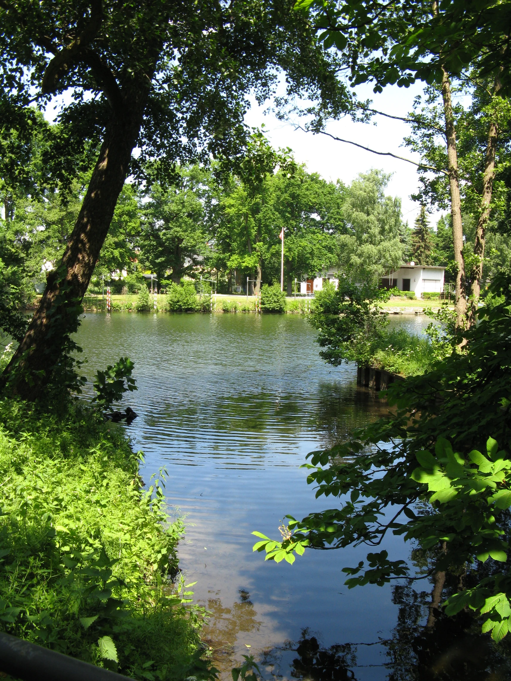
A view of a river confluence surrounded by lush green trees and vegetation on a sunny day.
The confluence of the Mittelbach stream and the Werre river in Bad Oeynhausen.

Mittelbach Nature Reserve history and protected-area timeline

The Mittelbach Nature Reserve was formally designated in 1998, extending protection to about two kilometers of the Mittelbach stream and its characteristic valley near Exter, a district of Vlotho in eastern Westphalia. Its establishment was part of broader efforts in North Rhine-Westphalia to safeguard the remaining near-natural stream valleys, or Sieke, of the Ravensberger Land, where centuries of agricultural use and settlement had left only fragments of the original humid valley landscape.

The reserve is registered in the state's nature information system under the code HF-034, reflecting its place alongside other small but ecologically significant protected areas in the Herford administrative region. Its designation recognized both the unusually well-developed box-shaped valley profile of the Mittelbach Siek and the combination of wet grassland, alder and beech woodlands, and orchard meadows that together make the site a representative fragment of regional heritage landscape.

Beyond its conservation role, the broader Mittelbach corridor carries traces of historical cultural use. The stream once supplied mechanical power to the Rürupsmühle at Löhne-Gohfeld downstream from the reserve. Today, the protected area near Exter stands as a deliberately preserved example of how a small valley reserve can hold both natural and cultural landscape values in a single compact site.

Mittelbach Nature Reserve landscape and geographic character

The landscape of the Mittelbach Nature Reserve is shaped primarily by the narrow, deeply cut stream valley of the Mittelbach near Exter in the northern Ravensberger Mulde, on the transition toward the southern Lipper Bergland. The defining form is a classic Siek: a tight, steep-walled moisture valley with only minor branching but a clearly developed box-shaped cross-section, in which the valley floor sits noticeably lower than the surrounding terrain and the banks rise sharply above it.

This pronounced profile gives the reserve a sense of enclosure unusual for the otherwise gently rolling Ravensberger farmland. The slopes above the Siek grade into the wider agricultural landscape of the Ravensberger Land, while the valley floor itself retains a distinctly green, humid character thanks to the groundwater influence from the small Mittelbach. The vertical drop between the spring area, at roughly 211 meters above sea level near the Steinegge, and the lower Werre valley is mirrored locally by the steep inner walls of the Siek at Exter.

The terrain of the reserve includes the moist, often flat valley bottom, the transitional slope where the woodland becomes denser, and the open side valleys (Nebensieke) that branch off the main Siek. Within this small frame, the landscape alternates between open wet meadows, dense clumps of alder, taller beech-mixed woodland on the better-drained edges, and orchard stands in the more open side valleys. The result is a compact, varied valley landscape rather than a single uniform habitat.

Mittelbach Nature Reserve ecosystems, habitats, and plant life

The ecological value of the Mittelbach Nature Reserve lies in its concentration of typical Ravensberger stream-valley habitats within a very small area. The reserve was explicitly designated to preserve the near-natural character of this Siek ecosystem, which combines running water, wet soils, groundwater-fed meadows, riparian woodland, and culturally shaped orchard habitats into one continuous landscape corridor.

The Siek itself is only weakly branched but has an unusually well-developed, high-walled profile, which keeps humidity and microclimate conditions on the valley floor distinct from the drier surrounding farmland. This sheltered setting supports alder-dominated wet woodland along parts of the stream, alongside stands of beech on slightly higher and drier ground. Where the soil is particularly waterlogged, the valley floor transitions into sedge and rush communities, with moisture-loving herbs such as Wassergreiskraut (marsh ragwort) characteristic of such damp streambank habitats.

In the side valleys of the Siek, the ecological gradient continues but shifts in character. These Nebensieke are wider and lighter than the main valley and are partly filled with old orchard meadows (Streuobstwiesen), a culturally shaped semi-open habitat type that adds further habitat diversity. Together, the watercourse, wet woodland, damp herb communities, and orchard meadows define the nature of the reserve as a small but representative cross-section of Ravensberger valley ecology.

Mittelbach Nature Reserve wildlife and species highlights

The wildlife value of the Mittelbach Nature Reserve reflects its character as a small, structurally rich stream-valley reserve embedded in a heavily used agricultural landscape. The combination of running water, dense alder thickets, beech woodland on the slopes, wet meadow strips, and old orchard stands in the side valleys creates a layered habitat structure favorable to many of the animal groups associated with humid lowland valleys in Westphalia.

The stream itself, together with its permanently wet banks and adjacent sedge and rush stands, supports the invertebrate and small aquatic faunas typical of cool lowland brooks. The dense alder and mixed deciduous woodland along the valley walls offers shelter and nesting sites for typical woodland songbirds, while the wet meadows in the valley bottom contribute open-ground insect life that benefits both birds and small mammals.

The orchard meadows in the side valleys are particularly important for species that depend on old trees, dead wood, and structural variety, including woodpeckers and other cavity-nesting birds, as well as a wide range of insects associated with blossom, fruit, and decaying wood. Although the reserve is small, this combination of aquatic, woodland, meadow, and orchard habitats concentrated within a single Siek makes it disproportionately valuable for local species diversity in the Ravensberger region.

Mittelbach Nature Reserve conservation status and protection priorities

The Mittelbach Nature Reserve is a small but locally important piece of the conservation network of eastern Westphalia. Its 34-hectare core area along the Mittelbach near Exter in Vlotho was legally designated in 1998 with the explicit goal of preserving a near-natural example of the Siek landscape that is characteristic of the Ravensberger Land and the northern Lipper Bergland.

From a conservation perspective, the reserve matters less for its size than for its representativeness. It preserves the box-shaped valley profile, the wet meadows, the alder and beech woodland stands, the sedge and rush communities, and the orchard meadows of the side valleys as a connected system rather than as isolated fragments. By holding this structure together along about two kilometers of stream, the reserve maintains ecological functions such as natural bank stabilization, shading, microclimate buffering, and habitat connectivity that would otherwise be lost in an intensively used lowland catchment.

The reserve is registered as protected area HF-034 within the state of North Rhine-Westphalia and contributes to the broader regional network of small nature reserves that safeguard surviving stream-valley and orchard landscapes across Ostwestfalen-Lippe. Its 1998 designation was part of a wider recognition that, in this densely settled region, even very small protected areas can be crucial reservoirs of characteristic lowland habitats.

Mittelbach Nature Reserve cultural meaning and human context

The Mittelbach Nature Reserve sits within a cultural landscape shaped by centuries of agricultural and small-scale industrial use. The Mittelbach itself once supplied mechanical power to the Rürupsmühle at Löhne-Gohfeld downstream of the reserve, illustrating how small Westphalian brooks historically supported local mills and rural livelihoods.

At the reserve itself, the most visible cultural element is the traditional orchard meadows in the side valleys. These Streuobstwiesen, with their scattered old fruit trees, are a hallmark of the Ravensberger Land and reflect historical land use in which valley floors combined meadow, pasture, and orchard functions. The continued presence of these orchards within a formally protected nature reserve shows how the modern conservation concept of the Mittelbach reserve explicitly integrates historical cultural land use with the protection of natural habitats.

Top sights and standout views in Mittelbach Nature Reserve

The Mittelbach Nature Reserve's strongest features are its classic Siek valley morphology, its unusually clear box-shaped cross-section, and the tight mosaic of wet woodland, wet meadow, and orchard habitats along the Mittelbach near Exter.

Within a small area, the reserve concentrates habitats that elsewhere in the Ravensberger Land have largely been reduced to fragments or lost entirely. It is this combination of near-natural stream-valley structure and surviving traditional cultural features, rather than any single dramatic landscape element, that defines the site's identity and conservation importance.

Best time to visit Mittelbach Nature Reserve

As a small, lowland stream-valley reserve, the Mittelbach Nature Reserve can be visited throughout much of the year. Late spring and early summer tend to bring the most lush expression of its wet meadows, sedge stands, and beech foliage, and they coincide with the blossoming of the old orchard trees in the side valleys. Late summer and autumn highlight the alder and beech woodland on the valley slopes and the changing character of the wet meadow flora, while winter offers a clearer view of the Siek's distinctive box-shaped valley profile once the leaves have fallen.

Visit character is influenced mostly by ground conditions rather than by park-wide seasonal closures; the steep valley walls, wet banks, and narrow paths mean the reserve can feel more atmospheric and easier to appreciate the structure of after light frost or in dry summer weather than during prolonged wet periods.

Monthly climate preview

Long-term temperature ranges and precipitation patterns across twelve recorded months

Naturschutzgebiet Mittelbach Climate Normals and Monthly Weather Records

Representative coordinate records show measured monthly averages ranging from freezing winter minimums to warm summer maximums alongside steady daily precipitation amounts. Detailed monthly comparisons provide complete historical baselines for temperature variation and moisture distribution across the protected area.
Annual mean9 °C
1 °C18 °C
Jan
Feb
Mar
Apr
May13°
Jun16°
Jul18°
Aug18°
Sep14°
Oct
Nov
Dec
Warmest month
July

18.1 °C

Coolest month
January

0.5 °C

Wettest month
December

2.6 mm/day

Driest month
April

1.6 mm/day

Park location guide

Geography guide, regional context, and park location map for Mittelbach Nature Reserve

Mittelbach Nature Reserve park geography, regions, and map view in Germany

Understand where Mittelbach Nature Reserve sits in Germany through a broader geographic reading of the surrounding landscape, nearby location context, and its mapped position within the national park landscape.

How Mittelbach Nature Reserve fits into Germany

Germany is a federal republic in Western and Central Europe with a population of over 83 million across sixteen constituent states. It is Europe's largest economy by nominal GDP and a major global exporter and importer. The capital is Berlin, and the country borders Denmark, Poland, Czech Republic, Austria, Switzerland, France, Luxembourg, Belgium, and the Netherlands.

Wider geography shaping Mittelbach Nature Reserve in Germany

Germany is located in Western and Central Europe, spanning 357,022 km². It borders Denmark to the north, Poland and the Czech Republic to the east, Austria and Switzerland to the south, and France, Luxembourg, Belgium, and the Netherlands to the west. The country has coastlines on the Baltic Sea and North Sea to the north, with the Alps located in the southern region.

Map view of Mittelbach Nature Reserve

Use this park location map to pinpoint Mittelbach Nature Reserve in Germany, understand its exact geographic position, and read its mapped placement within the surrounding landscape more clearly.

Pigeon | © OpenStreetMap contributors

Location context for Mittelbach Nature Reserve

North Rhine-Westphalia

Visualizing the steep walled valley topography and protected habitats

Naturschutzgebiet Mittelbach Photos and Landscape Scenery

Visual records reveal the distinctive box shaped profile of the Ravensberger Siek and its surrounding riparian habitats. Examining field photographs clarifies the compact mosaic of wet meadows, alder woodland, and orchard patches defining the protected stream valley.

A view of a river confluence surrounded by lush green trees and vegetation on a sunny day.

Park atlas

Compare regional stream valleys and connected nature reserves across eastern Westphalia

Other Parks Near Naturschutzgebiet Mittelbach and Surrounding Protected Landscapes

Expand geographic exploration by comparing Naturschutzgebiet Mittelbach with adjacent protected areas and stream valley reserves across the surrounding region. Reviewing nearby terrain types helps place localized valley habitats into a broader regional conservation framework.
A watercolor illustration of a rural landscape with a single prominent tree in the foreground, green hills in the distance, and soft fields in between.
Nature reserveNordrhein-Westfalen
About 7.2 km away#1 closest

Southeast

Kleiner Selberg Nature Reserve: Protected Landscape and Geographic Mapping

Essential geographic context for the Lipper Bergland protected areas

Kleiner Selberg stands as a prominent hill and nature reserve within the Kreis Herford region. Its landscape is defined by a dense population of juniper shrubs and restored heathland, offering a vital ecological corridor in the Weserbergland. Explore the spatial arrangement of its woodland patches and pasture slopes that characterize this protected hill environment.

Area
0.136 km²
Established
1971
Relief
Mountain
Climate
Temperate
Watercolor painting of a green, rolling landscape with trees and soft hills, rendered in a minimalist, light-toned style on a white background.
Nature reserveNordrhein-Westfalen
About 9.2 km away#2 closest

Southwest

In der Masch Nature Reserve: Mapped Floodplain Geography in Nordrhein-Westfalen

Protected nature reserve with rare lowland meadow habitats.

In der Masch offers a focused look at protected lowland river-meadow terrain within Germany. This 23-hectare nature reserve in Nordrhein-Westfalen protects interconnected oat-grass grasslands, riparian wood fringes, and historical boundary markers, providing a distinct study in regional floodplain topography and habitat preservation.

Area
0.23 km²
Established
2002
IUCN
IV
Nature reserveNorth Rhine-Westphalia
About 12 km away#3 closest

Northeast

Wittekindsberg Nature Reserve: Mapping Protected Forests and Jurassic Cliffs in Germany

A conservation-focused geographic analysis of the Wiehengebirge ridge

Wittekindsberg Nature Reserve represents a key protected landscape in northeastern North Rhine-Westphalia. Spanning the crest of the Wiehengebirge, the area is characterized by a mosaic of beech-dominated forests and Jurassic-age geological features. This atlas entry provides essential context on the reserve's topography, cliff-face habitats, and its role as a representative ecological site within the larger Natura 2000 network of the region.

Area
1.143 km²
Established
1990
IUCN
IV
Relief
Mountain
A watercolor painting showing a stylized landscape with rolling green hills, a winding path or stream, and distant purple mountains against a white background.
Nature reserveNorth Rhine-Westphalia
About 15 km away#4 closest

Southeast

Ilse Nature Reserve: Protected Stream Corridor and Floodplain Geography in North Rhine-Westphalia

Mapped riparian habitats and regional conservation landscape context.

Ilse Nature Reserve serves as a critical protected corridor within the Lippe district, spanning five distinct sections along the Ilse stream. The reserve is defined by its near-natural watercourse, wet meadows, and traditional orchard remnants that safeguard species-rich habitats. This geographic focus provides essential insights into the conservation of lowland stream ecosystems and their role in maintaining the ecological connectivity of the broader Bega river valley.

Area
0.142 km²
Established
2009
IUCN
IV
Relief
Upland
Watercolor illustration showing a calm lake surrounded by green trees and vegetation with rolling hills and a pink sky in the background
Nature reserveNorth Rhine-Westphalia
About 15 km away#5 closest

South

Heipker See Nature Reserve: Geographic Mapping of the Werre River Valley Landscape

Protected riparian habitat in North Rhine-Westphalia, Germany

Heipker See offers a detailed look into the landscape composition of an eastern Westphalian nature reserve. The protected area features a distinct concentration of stillwater, stream, and river-corridor habitats, providing essential space for migratory birds and demonstrating the ecological significance of small-scale landscape connectivity in the Werre valley region.

Area
0.246 km²
Established
1998
IUCN
IV
Relief
Lowland
A pale, soft-toned watercolor painting of a rolling landscape with green fields, forested areas, and a small winding stream under a light sky.
Nature reserveNordrhein-Westfalen
About 15 km away#6 closest

South

Holzhauser Bruch Nature Reserve: Protected Wetland and Riparian Geography in Nordrhein-Westfalen

Mapping lowland bog and meandering river corridors

Holzhauser Bruch in Nordrhein-Westfalen preserves a compact yet ecologically vital riverine landscape. Its terrain contrasts wet alder-dominated swamp forests with drier, sandy upland slopes. This summary explores the geographic boundary of the reserve, highlighting its role as a representative fragment of the Werre valley habitat system.

Area
0.4 km²
Established
2002
A soft watercolor illustration depicting a line of trees and greenery along a shoreline with rolling hills in the background.
Nature reserveKreis Lippe
About 15 km away#7 closest

East

Naturschutzgebiet Abgrabung Stemmen: Protected Landscape and Regional Geography in Kreis Lippe

Post-mining habitat restoration in North Rhine-Westphalia

Gain insights into the geography and conservation status of Naturschutzgebiet Abgrabung Stemmen. This 20-hectare nature reserve in Kreis Lippe showcases the development of ruderal grasslands, willow pioneer woodland, and wetland ecosystems across a reclaimed industrial site.

Area
0.2 km²
Established
1995
Nature reserveNordrhein-Westfalen
About 18 km away#8 closest

Southwest

Windweheniederung Nature Reserve: Geographic Atlas of an East Westphalian Floodplain

Riparian ecosystems and protected valley land mapping

Windweheniederung represents a specialized nature reserve in Nordrhein-Westfalen that centers on the natural morphology of the Windwehe stream. This protected area provides a critical refuge for wetland-dependent species through its alder-ash woodland and reed-fringed pools. Explore the structural geography of this lowland catchment and understand its role in maintaining functional floodplains amidst a heavily developed regional environment.

Area
0.297 km²
Established
1991
IUCN
IV

Common questions about visiting, size, designation, and location context for Mittelbach Nature Reserve

Mittelbach Nature Reserve FAQs for park facts, access, geography, and protected area context

Find quick answers about Mittelbach Nature Reserve, including protected-area facts, park geography, trail and visitor context, and how the park fits into its surrounding country and regional landscape.
MoriAtlas Explorer

Continue Your Protected Areas Search Across the Global Atlas

Deepen your exploration by continuing the structured search for national parks and protected areas worldwide. Utilize the comprehensive filtering capabilities to compare different conservation landscapes and refine your understanding of global park geography. Discover more about the distribution and characteristics of protected natural areas.

Global natural geography