
Mori Atlas logo
Nature reserveKleiner Selberg

A detailed geographic examination of juniper heath and woodland habitats within the Weserbergland region

Kleiner Selberg Nature Reserve: Exploring Protected Landscapes and Terrain in the Lipper Bergland

(Naturschutzgebiet Kleiner Selberg)

Kleiner Selberg represents a distinct protected area in the Lipper Bergland of North Rhine-Westphalia, Germany. This 271-meter hill preserves a rare mosaic of juniper heath, bilberry-dominated dwarf shrubland, and nutrient-poor grasslands. By examining the mapped boundaries and surrounding topography, you can understand how this nature reserve connects ecologically to the nearby Linnenbeeke valley and its broader regional context.

juniper heathnature reserveLipper BerglandWeserberglandheathland restorationdwarf shrub heath
A flat-style vector illustration showing a winding river flowing through a forested valley flanked by rocky mountains, with a waterfall on the right and a large sun in the background.

Kleiner Selberg

Nature reserve

Park overview

Structured park overview, official facts, and landscape profile for Kleiner Selberg

Kleiner Selberg park facts, protected area profile, and essential visitor context

Review the core facts for Kleiner Selberg, including designation, size, terrain, visitor scale, habitats, and operating context in one park-focused overview.

About Kleiner Selberg

Kleiner Selberg is a small but ecologically distinctive hill within the Lipper Bergland, the eastern sub-range of the Weserbergland in North Rhine-Westphalia. Reaching 271.7 meters above sea level, it ranks among the ten highest summits of the Kreis Herford and sits east of the Valdorf district of Vlotho. Just to the west rises the companion summit Großer Selberg, while the Bonstapel and Nettelberg lie southeast and the Linnenbeeke brook flows along the eastern flank of the hill.

The hill's conservation significance lies in its protected status as part of the Naturschutzgebiet Kleiner Selberg, a nature reserve of about 13.6 hectares designated in 1971 and renewed under the 1998 landscape plan of Vlotho. The reserve adjoins the Linnenbeeke nature reserve and shares its conservation purpose with the nearby Eiberg reserve: safeguarding juniper heath, woodland, and nutrient-poor grasslands across both the hill slopes and the associated small brook valley.

In ecological terms, the hill displays a striking contrast between slopes. The north-facing slope carries a bilberry-dominated dwarf shrub heath whose upper portions are studded with junipers, alongside protected ferns such as the mountain male fern and the wall rue-related hard fern, while the east-facing slope holds more nutrient-rich meadow and pasture vegetation. The combination of dry heath on the upper hill and more mesic grassland below has produced a habitat mosaic attractive to rare and protected species, including the red-backed shrike, the tree pipit, the small copper butterfly, and the field cricket.

Because Kleiner Selberg is part of a network of small, locally administered nature reserves within the Vlotho and Kreis Herford area, the hill is less a destination in the conventional scenic sense and more a working example of regional heath conservation in North Rhine-Westphalia, integrated into the larger East Westphalia-Lippe nature protection landscape.

Quick facts and research context for Kleiner Selberg

Kleiner Selberg is a hill reaching 271.7 meters in the Lipper Bergland portion of the Weserbergland, located east of Valdorf in the town of Vlotho, North Rhine-Westphalia. The hill and its immediate surroundings have been protected as the Naturschutzgebiet Kleiner Selberg, first designated in 1971 and renewed under the 1998 Vlotho landscape plan, with the protected area covering approximately 13.6 hectares.

The reserve protects a juniper heath, forests, and poor grasslands along the hill and in the adjacent Linnenbeeke brook valley. By 2013, more than 1,000 juniper bushes, some up to four meters tall, were recorded. The site borders the Linnenbeeke nature reserve and is administered within the Kreis Herford, where ongoing conservation work focuses on maintaining the open heath character and the recovery of heather vegetation.

Protection and recognition

Documented conservation records and establishment metrics for Kleiner Selberg

Kleiner Selberg Protection Status and Terrestrial Designation History

Kleiner Selberg maintains a terrestrial protection scope established through official designation records dating from 1998. Review structured conservation data, management parameters, and verified international recognition metrics for this protected area.

Protection details

Protection scope
Terrestrial
Designated year
1998
Transboundary protection
No
Park context

Deeper park guide and search-rich context for Kleiner Selberg

Kleiner Selberg history, landscape, wildlife, and travel context

Explore Kleiner Selberg through its history, landscape character, ecosystems, wildlife, conservation priorities, cultural context, and seasonal travel timing in a structured park guide built for atlas discovery and search intent.

Why Kleiner Selberg stands out

Kleiner Selberg is best known for its protected juniper heath (Wacholderheide), a comparatively rare cultural landscape habitat in the region. The reserve preserves a mosaic of juniper shrubs, woodland, bilberry-dominated dwarf shrub heath, and nutrient-poor grasslands along a modest but ecologically significant hill in the Lipper Bergland. It is also recognized for its conservation history: the hill was nearly bare in the 1930s, was partially reforested on its western slopes, and has since been managed through shrub removal, soil stripping, and heather reintroduction to revive characteristic heath vegetation. The presence of species such as the red-backed shrike, tree pipit, small copper butterfly, and field cricket underscores its continued ecological value as a small but rich nature reserve in East Westphalia-Lippe.
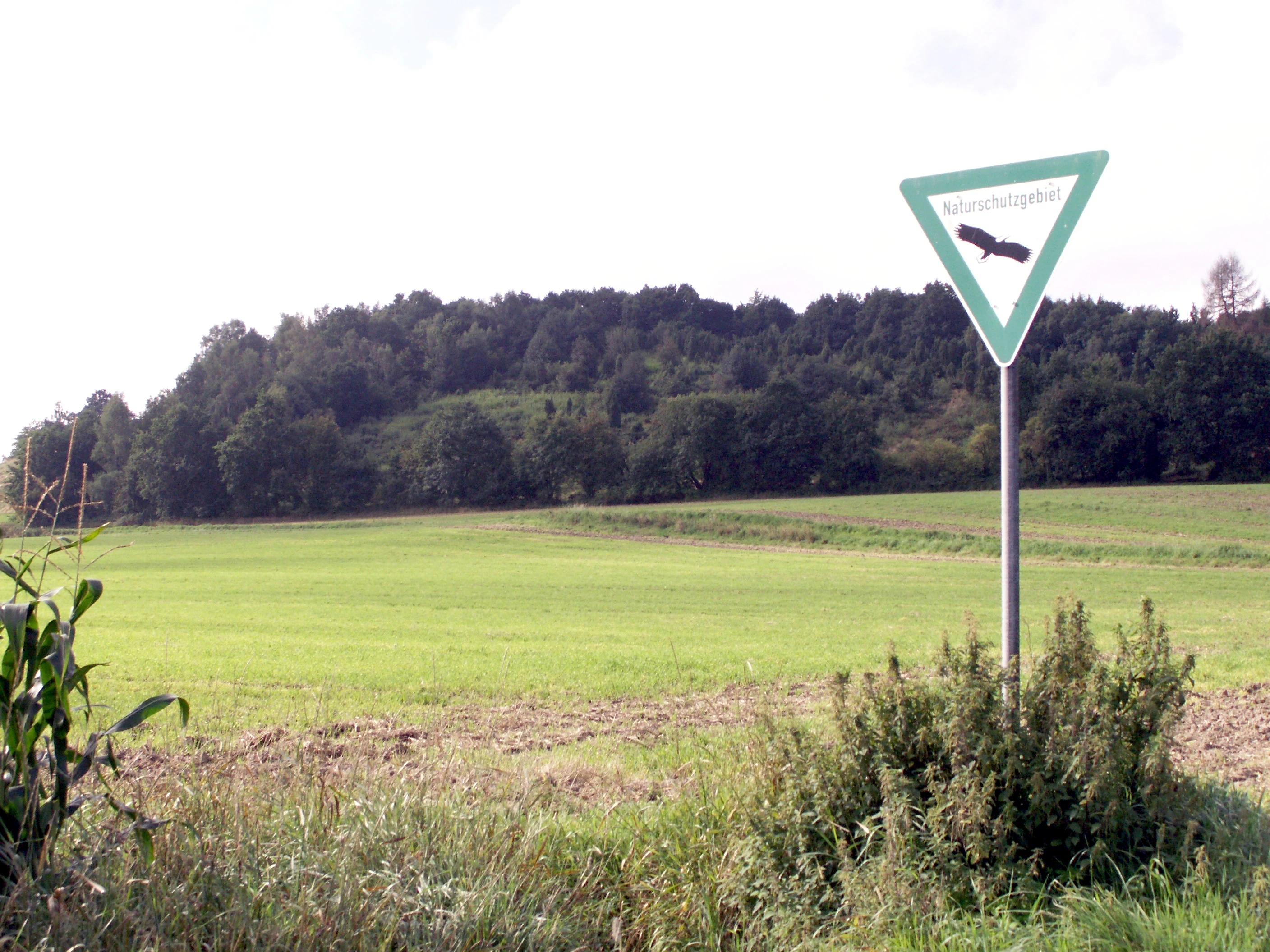
A triangular green and white nature reserve sign on a pole overlooks a green meadow with a dense, tree-covered hill in the background.
A nature reserve sign marks the entrance area of the Kleiner Selberg preserve in Vlotho, Germany.

Kleiner Selberg history and protected-area timeline

The hill's recent ecological history is closely tied to changing land use. In the 1930s the Kleiner Selberg was still nearly bare of woody vegetation, an open state consistent with traditional grazing use. During that decade the western, steeper slope sections were planted with shrubs and trees, after which woody vegetation began to spread across additional parts of the hill.

The site was first designated as the Naturschutzgebiet Kleiner Selberg in 1971, establishing formal protection for its juniper heath, woodland, and poor grassland habitats. A renewed designation followed in 1998 through the landscape plan (Landschaftsplan) of Vlotho, reaffirming and updating conservation boundaries and management objectives for the area.

The Kreis Herford acquired the heath areas on the north-eastern side of the hill and has maintained them through regular 'Entkusseln', the removal of encroaching shrubs. Traditional sheep grazing was carried out only sporadically in recent decades. In 2008 and 2009, partial sections were stripped of their topsoil and vegetation with excavators and other equipment, and the exposed raw soil was seeded with heather from the Senne region to encourage recolonization. After many young heather plants died back during the dry summer of 2010, additional heather seed was introduced in 2011, leading to successful recolonization of the stripped areas. These restoration measures were supported by the state of North Rhine-Westphalia and the European Union.

In the south and southeast of the reserve, meadow areas are now managed extensively under contract nature conservation agreements: they are no longer fertilized and are only mown after 15 June, supporting late-season flowering and invertebrates.

Kleiner Selberg landscape and geographic character

Kleiner Selberg is a low but prominent hill crowning the surrounding agricultural and forested land of the eastern Lipper Bergland. At 271.7 meters it is not high in absolute terms, but within the rolling terrain of the Vlotho area it forms part of the most notable group of summits in the Kreis Herford, paired visually and topographically with the slightly higher Großer Selberg immediately to the west.

The physical character of the hill is shaped by contrasting slope aspects. The north-facing slope, sheltered and cooler, supports bilberry-dominated dwarf shrub heath and a band of taller junipers higher up, giving way to the steeper, partially wooded western flank. The east-facing slope is more open and carries nutrient-richer meadows and pastures, while the southeastern foot of the hill connects to the Bonstapel and Nettelberg heights. Across the eastern side flows the Linnenbeeke, a small brook whose spring lies at the Bonstapel, creating the moist valley habitat that links the Kleiner Selberg reserve to the neighboring Linnenbeeke nature reserve.

Overall, the landscape impression is one of a small, rounded hill harboring a fine-grained mosaic of dry heath, shrubs, woodland patches, and grassy slopes, set against the broader rural scenery of the Weserbergland foothills.

Kleiner Selberg ecosystems, habitats, and plant life

Ecologically, Kleiner Selberg is defined by its heathland character, one of the more unusual habitat types preserved in the Lipper Bergland. The protected area safeguards a juniper heath (Wacholderheide) populated by more than 1,000 juniper bushes, some reaching four meters in height, alongside mixed woodland and nutrient-poor meadows and pastures. These habitats are conservation priorities because traditional juniper heaths have become rare across much of central Germany.

The vegetation shows a clear pattern related to slope and soil conditions. On the north slope, dry conditions favor a dwarf shrub heath dominated by bilberry, with junipers concentrated in the upper zone. The hill also supports protected fern species, including the mountain male fern and the hard fern, which add to the botanical interest of the woodland fringes. On the east slope, deeper soils and more nutrient availability support richer meadows and pastures.

The reserve is therefore best understood as a small, structurally diverse landscape: dry, juniper-rich upper slopes and cool, bilberry-clad north-facing slopes contrast with more mesic grassland and the moist habitats along the Linnenbeeke valley that fringes the protected area.

Kleiner Selberg wildlife and species highlights

Although a small site, Kleiner Selberg supports several rare and protected species, reflecting the value of its heath-grassland mosaic for invertebrates, birds, and other fauna. Bird records from within the nature reserve include the red-backed shrike, a characteristic species of open countryside rich in shrubs and insects, and the tree pipit, a ground-nesting songbird of heath edges and light woodland.

The invertebrate fauna is equally notable. The protected small copper butterfly has been documented in the area, alongside the field cricket, an insect that thrives in the warm, dry, low-vegetation conditions maintained by the reserve's management. The combination of dry juniper heath, open meadows, and nearby brook-side vegetation in the adjoining Linnenbeeke reserve likely supports additional insect diversity, even where the official records focus on these few highlighted species.

Overall, the wildlife significance of Kleiner Selberg lies less in richness of large mammals and more in the persistence of specialized heathland species that depend on the open, warm, shrub-rich conditions actively maintained by the reserve's conservation work.

Kleiner Selberg conservation status and protection priorities

Kleiner Selberg's conservation value centers on the protection and active restoration of a juniper heath landscape within the Lipper Bergland. The site has been formally protected as a nature reserve since 1971 and was reaffirmed through the 1998 Vlotho landscape plan, covering around 13.6 hectares of juniper heath, woodland, and nutrient-poor grassland that connects ecologically to the adjoining Linnenbeeke nature reserve.

Active management has been central to the reserve's character. The Kreis Herford owns key heath areas on the north-eastern side of the hill and carries out regular shrub removal to prevent woodland encroachment. Where shrub cover advanced, restoration crews in 2008 and 2009 stripped topsoil and reseeded using heather sourced from the Senne region, a technique aimed at re-establishing the typical heath flora. A follow-up seeding in 2011 compensated for losses during the very dry summer of 2010, and the stripped plots were subsequently colonized by numerous young heather plants.

In the southern and southeastern parts of the reserve, grassland is managed under contract nature conservation: meadows are no longer fertilized and are mown only after 15 June, ensuring late-season habitats for insects and wild plants. These measures, supported by the state of North Rhine-Westphalia and the European Union, together with the long-standing protection status, make Kleiner Selberg a representative example of small-scale, intensively managed heath conservation in East Westphalia-Lippe.

Kleiner Selberg cultural meaning and human context

The cultural context of Kleiner Selberg is tied to the long tradition of grazing and small-scale agriculture on hills in the Lipper Bergland. Extensive historical grazing is what kept the hill nearly bare of woody vegetation as late as the 1930s and shaped the open heath character that is now actively conserved. The partial reforestation of the steeper western slopes in the 1930s represents a turning point in that traditional land-use pattern.

In the broader regional sense, the hill belongs to the Weserbergland, a landscape with strong identity in northern German cultural geography, and it is documented as part of the cluster of protected areas (Naturschutzgebiete) within the Vlotho area, alongside the Eiberg, Linnenbeeke, and other neighboring reserves. The reserve also appears in regional scientific literature, such as a 2013 comparative study of nature reserves in the Kreis Herford, indicating its recognized place within local natural history and conservation scholarship.

Top sights and standout views in Kleiner Selberg

The standout features of Kleiner Selberg are its protected juniper heath with more than 1,000 recorded juniper bushes, its bilberry-dominated dwarf shrub heath on the cooler north slope, and its mosaic of dry heath, woodland, and nutrient-poor grassland along a small Weserbergland hill. The reserve's value is reinforced by its direct ecological linkage with the neighboring Linnenbeeke nature reserve and its parallel conservation role with the nearby Eiberg reserve.

Equally notable is the reserve's active restoration record: soil-stripping operations in 2008 and 2009, supported by NRW and EU funding, followed by a successful 2011 heather reseeding that revived typical heath vegetation on former bare plots. The 2013 comparative study of nature reserves in the Kreis Herford by Heinz Lienenbecker provides a documented scientific baseline for the site's flora and fauna.

Best time to visit Kleiner Selberg

Because Kleiner Selberg is a small nature reserve centered on heath and juniper habitats, late spring through early autumn is the most rewarding period to visit, when the heath vegetation is fully developed and species such as butterflies and birds are most active. The dwarf shrub heath on the north slope and the juniper stands are best appreciated in late spring and summer, when the bilberry foliage and juniper foliage are in full growth and insects such as the small copper butterfly are on the wing.

Late summer also reveals the conservation result of the reserve's mowing regime in the southern meadows, which are not cut until after mid-June, allowing late-flowering plants and seed set. Visitors in cooler months will find a quieter, more subdued landscape, with bare juniper silhouettes and fewer active species, but the underlying heath mosaic remains structurally visible year-round.

Monthly climate preview

Examine measured long term temperature ranges and monthly precipitation distributions for Kleiner Selberg.

Kleiner Selberg Climate Normals and Annual Weather Patterns by Month

Historical records from the representative coordinate show how average temperatures and precipitation levels shift across the twelve-month cycle. Accessing the complete climate profile provides deeper monthly comparisons for temperature minimums and maximums.
Annual mean9 °C
1 °C18 °C
Jan
Feb
Mar
Apr
May13°
Jun16°
Jul18°
Aug18°
Sep14°
Oct
Nov
Dec
Warmest month
July

18.1 °C

Coolest month
January

0.5 °C

Wettest month
December

2.6 mm/day

Driest month
April

1.6 mm/day

Park location guide

Geography guide, regional context, and park location map for Kleiner Selberg

Kleiner Selberg park geography, regions, and map view in Germany

Understand where Kleiner Selberg sits in Germany through a broader geographic reading of the surrounding landscape, nearby location context, and its mapped position within the national park landscape.

How Kleiner Selberg fits into Germany

Germany is a federal republic in Western and Central Europe with a population of over 83 million across sixteen constituent states. It is Europe's largest economy by nominal GDP and a major global exporter and importer. The capital is Berlin, and the country borders Denmark, Poland, Czech Republic, Austria, Switzerland, France, Luxembourg, Belgium, and the Netherlands.

Wider geography shaping Kleiner Selberg in Germany

Germany is located in Western and Central Europe, spanning 357,022 km². It borders Denmark to the north, Poland and the Czech Republic to the east, Austria and Switzerland to the south, and France, Luxembourg, Belgium, and the Netherlands to the west. The country has coastlines on the Baltic Sea and North Sea to the north, with the Alps located in the southern region.

Map view of Kleiner Selberg

Use this park location map to pinpoint Kleiner Selberg in Germany, understand its exact geographic position, and read its mapped placement within the surrounding landscape more clearly.

Pigeon | © OpenStreetMap contributors

Location context for Kleiner Selberg

Nordrhein-Westfalen

Examine the habitats, slope aspects, and protected landscape character of the Lipper Bergland hill.

Kleiner Selberg Photos and Landscape Scenery: Visualizing the Juniper Heath and Protected Terrain

Photographic documentation reveals the distinct terrain, juniper shrubs, and dwarf shrub heath characterizing the protected slopes of Kleiner Selberg. Visual reference imagery captures the varied microclimates and vegetation mosaics shaping this notable nature reserve in East Westphalia.

A triangular green and white nature reserve sign on a pole overlooks a green meadow with a dense, tree-covered hill in the background.

A lone birch tree stands in the foreground, with agricultural fields and forested hills visible in the background under a cloudy sky.

Park atlas

Compare adjacent hill reserves, regional terrain, and connected nature conservation areas.

Exploring Parks Near Kleiner Selberg and Surrounding Protected Landscapes

Visitors exploring Kleiner Selberg can browse nearby nature reserves and protected areas across the surrounding Lipper Bergland. Comparing adjacent terrain features and regional park geography reveals broader habitat patterns throughout the Weserbergland foothills.
A watercolor illustration of a calm stream flowing through a green valley with trees and gentle hills in the background.
Nature reserveNorth Rhine-Westphalia
About 7.2 km away#1 closest

Northwest

Naturschutzgebiet Mittelbach Nature Reserve: Mapped Protected Landscapes in Vlotho

Classic Siek stream valley geography and riparian woodland habitats

The Naturschutzgebiet Mittelbach is a protected area in eastern Westphalia that defines the local landscape with its deeply cut moisture-rich valley. This site serves as a vital reference for the traditional Ravensberger Siek morphology, preserving a compact ecological network of sedge communities, beech forest patches, and riparian alder stands along a two-kilometer stream stretch.

Area
0.341 km²
Established
1998
Relief
Upland
Climate
Temperate
A watercolor painting showing a stylized landscape with rolling green hills, a winding path or stream, and distant purple mountains against a white background.
Nature reserveNorth Rhine-Westphalia
About 8.7 km away#2 closest

South

Ilse Nature Reserve: Protected Stream Corridor and Floodplain Geography in North Rhine-Westphalia

Mapped riparian habitats and regional conservation landscape context.

Ilse Nature Reserve serves as a critical protected corridor within the Lippe district, spanning five distinct sections along the Ilse stream. The reserve is defined by its near-natural watercourse, wet meadows, and traditional orchard remnants that safeguard species-rich habitats. This geographic focus provides essential insights into the conservation of lowland stream ecosystems and their role in maintaining the ecological connectivity of the broader Bega river valley.

Area
0.142 km²
Established
2009
IUCN
IV
Relief
Upland
A soft watercolor illustration depicting a line of trees and greenery along a shoreline with rolling hills in the background.
Nature reserveKreis Lippe
About 11 km away#3 closest

Northeast

Naturschutzgebiet Abgrabung Stemmen: Protected Landscape and Regional Geography in Kreis Lippe

Post-mining habitat restoration in North Rhine-Westphalia

Gain insights into the geography and conservation status of Naturschutzgebiet Abgrabung Stemmen. This 20-hectare nature reserve in Kreis Lippe showcases the development of ruderal grasslands, willow pioneer woodland, and wetland ecosystems across a reclaimed industrial site.

Area
0.2 km²
Established
1995
Watercolor painting of a green, rolling landscape with trees and soft hills, rendered in a minimalist, light-toned style on a white background.
Nature reserveNordrhein-Westfalen
About 11 km away#4 closest

West

In der Masch Nature Reserve: Mapped Floodplain Geography in Nordrhein-Westfalen

Protected nature reserve with rare lowland meadow habitats.

In der Masch offers a focused look at protected lowland river-meadow terrain within Germany. This 23-hectare nature reserve in Nordrhein-Westfalen protects interconnected oat-grass grasslands, riparian wood fringes, and historical boundary markers, providing a distinct study in regional floodplain topography and habitat preservation.

Area
0.23 km²
Established
2002
IUCN
IV
A watercolor painting showing a soft, green landscape with gentle rolling hills and a stream flowing through a grassy area.
Nature reserveKreis Lippe
About 12 km away#5 closest

Southeast

Quellbereich der Osterkalle: Protected Nature Reserve and Kastental Valley Atlas

A preserved stream valley landscape in Kreis Lippe

Quellbereich der Osterkalle is a protected nature reserve encompassing roughly 23 hectares of stream valley and hillside habitat. Defined by its characteristic box-shaped Kastental profile, the reserve maintains a near-natural brook system surrounded by riparian trees, wet meadows, and traditional sheep-grazed slopes within the Kreis Lippe district.

Area
0.23 km²
Established
1995
Relief
Upland
Scope
Terrestrial
Nature reserveNorth Rhine-Westphalia
About 14 km away#6 closest

North

Wittekindsberg Nature Reserve: Mapping Protected Forests and Jurassic Cliffs in Germany

A conservation-focused geographic analysis of the Wiehengebirge ridge

Wittekindsberg Nature Reserve represents a key protected landscape in northeastern North Rhine-Westphalia. Spanning the crest of the Wiehengebirge, the area is characterized by a mosaic of beech-dominated forests and Jurassic-age geological features. This atlas entry provides essential context on the reserve's topography, cliff-face habitats, and its role as a representative ecological site within the larger Natura 2000 network of the region.

Area
1.143 km²
Established
1990
IUCN
IV
Relief
Mountain
A pale, soft-toned watercolor painting of a rolling landscape with green fields, forested areas, and a small winding stream under a light sky.
Nature reserveNordrhein-Westfalen
About 14 km away#7 closest

Southwest

Holzhauser Bruch Nature Reserve: Protected Wetland and Riparian Geography in Nordrhein-Westfalen

Mapping lowland bog and meandering river corridors

Holzhauser Bruch in Nordrhein-Westfalen preserves a compact yet ecologically vital riverine landscape. Its terrain contrasts wet alder-dominated swamp forests with drier, sandy upland slopes. This summary explores the geographic boundary of the reserve, highlighting its role as a representative fragment of the Werre valley habitat system.

Area
0.4 km²
Established
2002
Watercolor illustration showing a calm lake surrounded by green trees and vegetation with rolling hills and a pink sky in the background
Nature reserveNorth Rhine-Westphalia
About 14 km away#8 closest

Southwest

Heipker See Nature Reserve: Geographic Mapping of the Werre River Valley Landscape

Protected riparian habitat in North Rhine-Westphalia, Germany

Heipker See offers a detailed look into the landscape composition of an eastern Westphalian nature reserve. The protected area features a distinct concentration of stillwater, stream, and river-corridor habitats, providing essential space for migratory birds and demonstrating the ecological significance of small-scale landscape connectivity in the Werre valley region.

Area
0.246 km²
Established
1998
IUCN
IV
Relief
Lowland

Common questions about visiting, size, designation, and location context for Kleiner Selberg

Kleiner Selberg FAQs for park facts, access, geography, and protected area context

Find quick answers about Kleiner Selberg, including protected-area facts, park geography, trail and visitor context, and how the park fits into its surrounding country and regional landscape.
MoriAtlas Explorer

Continue Your Protected Areas Search Across the Global Atlas

Deepen your exploration by continuing the structured search for national parks and protected areas worldwide. Utilize the comprehensive filtering capabilities to compare different conservation landscapes and refine your understanding of global park geography. Discover more about the distribution and characteristics of protected natural areas.

Global natural geography