

Mori Atlas logo
Protected areaHobyo National Park

Mapping the protected boundaries and regional geography of Hobyo National Park.

Hobyo National Park Protected Area: Geographic Context and Landscape Identity in Somalia

Hobyo National Park represents a distinct protected area situated within the Horn of Africa region of Somalia. This page offers an atlas-focused exploration of its geographic scope, allowing for a detailed understanding of its mapped boundaries and its place within the broader natural landscape context of East Africa. Discover the unique identity of this protected land through its regional geography.

coastal dunesdesert ecosystemendemic speciesHorn of Africaprotected areaSomalia

Hobyo National Park

Protected area

Park overview

Structured park overview, official facts, and landscape profile for Hobyo National Park

Hobyo National Park park facts, protected area profile, and essential visitor context

Review the core facts for Hobyo National Park, including designation, size, terrain, visitor scale, habitats, and operating context in one park-focused overview.

About Hobyo National Park

Hobyo National Park represents Somalia's effort to preserve a globally significant but highly threatened coastal ecosystem. The protected area encompasses the Hobyo grasslands and shrublands ecoregion, a desert and xeric scrubland environment that forms a narrow but ecologically critical strip along the Indian Ocean coastline. The region's defining feature is its extensive dune system, which reaches up to 60 meters in height and penetrates 10 to 15 kilometers inland from the coast. These geologically recent dunes overlay ancient Precambrian rock formations, with limestone outcrops emerging among the sand to create microhabitats with enhanced moisture retention. The park sits within the Central Somali coast Endemic Bird Area, recognizing its international significance for bird conservation. Despite its ecological importance, the entire ecoregion remains outside formal protected area status, making national park designation particularly meaningful for long-term conservation.

Quick facts and research context for Hobyo National Park

Hobyo National Park occupies a narrow coastal strip along Somalia's Indian Ocean shoreline in the Central Somali coast region. The protected area encompasses the Hobyo grasslands and shrublands ecoregion, which spans roughly 26,200 square kilometers of desert and xeric scrubland habitat. The landscape is dominated by white and orange sand dunes that sit atop ancient Precambrian bedrock, with occasional limestone outcrops providing shelter for more diverse plant communities. The climate is tropical and persistently hot, with minimal seasonal temperature variation and approximately 200 millimeters of annual rainfall concentrated in the April-to-June period.

Protection and recognition

Verifying terrestrial designation status and boundaries in the regional conservation database

Documented Protection Status and Conservation Framework for Hobyo National Park

Documented terrestrial protection records clarify the conservation framework and management scope established for Hobyo National Park. Evaluating official boundary records helps researchers understand regional reserve integration and terrestrial designation history across the region.

Protection details

Protection scope
Terrestrial
Park context

Deeper park guide and search-rich context for Hobyo National Park

Hobyo National Park history, landscape, wildlife, and travel context

Explore Hobyo National Park through its history, landscape character, ecosystems, wildlife, conservation priorities, cultural context, and seasonal travel timing in a structured park guide built for atlas discovery and search intent.

Why Hobyo National Park stands out

Hobyo National Park is most notable for protecting one of the Horn of Africa's most distinctive coastal dune ecosystems and the unique wildlife adapted to it. The park safeguards several endemic species found nowhere else on Earth, including the silver dik-dik and Somali golden mole among mammals, and Ash's lark and Obbia lark among birds. The ecoregion represents a critical refuge for specialized antelope species such as the dibatag, Soemmerring's gazelle, Salt's dik-dik, and Speke's gazelle. The contrast between the sweeping coastal dunes and the denser evergreen thickets near the shoreline creates a visually striking landscape atypical of typical desert environments.

Hobyo National Park history and protected-area timeline

The formal designation of Hobyo National Park reflects Somalia's commitment to conserving its unique coastal biodiversity despite significant national challenges. The Hobyo grasslands and shrublands ecoregion was recognized internationally through its classification as a vulnerable ecosystem, highlighting the urgency of establishing formal protection. The park's establishment represents an effort to secure protection for an area that had previously fallen outside any protected area network, addressing the conservation gap where zero percent of this ecoregion was previously protected. This designation provides institutional framework for managing one of Somalia's most distinctive natural landscapes.

Hobyo National Park landscape and geographic character

The physical landscape of Hobyo National Park is dominated by an impressive coastal dune system that defines the region's character. The dunes form a continuous belt along the Indian Ocean, extending roughly 800 kilometers along Somalia's low-lying coastal plain. These massive sand formations reach heights of up to 60 meters and are composed of distinctive white or orange sand that creates a striking visual contrast against the deep blue ocean. The dunes extend between 10 and 15 kilometers inland from the coastline, gradually transitioning to dry savanna and semi-desert scrublands. Among the dune formations, occasional limestone outcrops emerge, creating rocky outcliffs that interrupt the otherwise uniform sandy terrain. The coastal plain itself remains remarkably flat and low-lying, with the dunes being the primary topographic variation across the landscape.

Hobyo National Park ecosystems, habitats, and plant life

The ecological character of Hobyo National Park centers on specialized plant communities adapted to harsh coastal desert conditions. Dune grassland represents the most widespread plant community across the protected area, with specialized grasses and herbaceous plants anchoring the shifting sands. The dunes support succulent plants and cushion plants that store moisture during the brief wet season, alongside low shrubs that can survive the prolonged dry periods. Nearer to the coast, denser evergreen thickets develop where coastal breezes provide slightly elevated humidity while keeping vegetation low through constant wind exposure. Key shrub species include Aerva javanica and Indigofera sparteola. The limestone gorges scattered throughout the dunes provide crucial refugia with deeper soils and enhanced moisture retention, supporting a distinct bushland community including Buxus hildebrandtii and Dirachma somalensis.

Hobyo National Park wildlife and species highlights

The wildlife of Hobyo National Park includes several species found nowhere else on Earth, making the protected area globally significant for biodiversity conservation. Among mammals, the silver dik-dik and Somali golden mole represent true endemics restricted to this ecoregion. The park also supports populations of several antelope species with limited distributions in the Horn of Africa, including the dibatag, Soemmerring's gazelle, Salt's dik-dik, and Speke's gazelle. The bird fauna includes two endemic species: Ash's lark and Obbia lark, both confined to the Central Somali coast region. Among reptiles, Haackgreerius miopus and Latastia cherchii are endemic to these coastal dunes. The specialized mammal and bird communities reflect the unique evolutionary isolation of this coastal ecosystem.

Hobyo National Park conservation status and protection priorities

Hobyo National Park addresses a critical conservation need for one of Africa's most vulnerable coastal ecosystems. The Hobyo grasslands and shrublands ecoregion carries a vulnerable conservation status, reflecting the pressures from human activity and environmental change across its range. Significantly, prior to national park designation, zero percent of this ecoregion fell within any protected area network, leaving its unique biodiversity completely unprotected by formal conservation mechanisms. The park's establishment represents an attempt to correct this gap and provide institutional protection for an ecosystem that supports multiple endemic species. The ongoing challenge involves balancing conservation needs with the reality that most of the ecoregion remains sparsely populated with soils poorly suited to agriculture, creating both opportunities and constraints for effective management.

Top sights and standout views in Hobyo National Park

Hobyo National Park offers exceptional value as a conservation landscape protecting Horn of Africa endemic species. The coastal dune ecosystem represents one of East Africa's most significant sand dune systems, with dunes reaching 60 meters in height across an 800-kilometer coastal stretch. The park provides critical habitat for the silver dik-dik and Somali golden mole, two mammal species found nowhere else on the planet. Birdwatchers may encounter Ash's lark and Obbia lark, both endemic to this stretch of Somali coastline. The transition from coastal dunes through evergreen thickets to inland savanna creates remarkable habitat diversity within a relatively compact area.

Best time to visit Hobyo National Park

Visitors to Hobyo National Park should anticipate consistently hot and dry conditions year-round, with temperatures typically ranging between 21 and 33 degrees Celsius. The most favorable conditions occur during the cooler dry seasons, though the park experiences limited rainfall throughout the year with most precipitation falling between April and June. The landscape maintains its character regardless of season, though the brief rainy period may bring temporary greening of grasslands. Travelers should prepare for desert conditions and limited infrastructure typical of Somalia's coastal regions.

Monthly climate preview

Long-term monthly temperature cycles and precipitation rhythms measured at a representative coordinate

Hobyo National Park Climate Normals, Average Temperature and Precipitation Patterns

Historical data records a measured annual temperature range from 25.31 °C to 28.39 °C alongside varying monthly precipitation rates across the representative coordinate. Analyzing the complete twelve-month climatology profile provides deeper insight into long-term environmental patterns for this protected location.
Annual mean27 °C
25 °C28 °C
Jan26°
Feb26°
Mar28°
Apr28°
May28°
Jun26°
Jul25°
Aug25°
Sep26°
Oct27°
Nov27°
Dec27°
Warmest month
April

28.4 °C

Coolest month
July

25.3 °C

Wettest month
April

3 mm/day

Driest month
January

0.2 mm/day

Park location guide

Geography guide, regional context, and park location map for Hobyo National Park

Hobyo National Park park geography, regions, and map view in Somalia

Understand where Hobyo National Park sits in Somalia through a broader geographic reading of the surrounding landscape, nearby location context, and its mapped position within the national park landscape.

How Hobyo National Park fits into Somalia

Somalia is a federal parliamentary republic located at the easternmost point of continental Africa. Formerly colonised by Britain and Italy, it gained independence in 1960 when British and Italian Somaliland merged. The country has endured prolonged civil conflict since 1991 but has recently stabilised under a federal government. Mogadishu serves as both the capital and largest city.

Wider geography shaping Hobyo National Park in Somalia

Somalia occupies the Horn of Africa region, stretching along the eastern coast of the continent. It borders Ethiopia to the west, Djibouti to the northwest, Kenya to the southwest, the Gulf of Aden to the north, and the Indian Ocean to the east. The terrain is predominantly arid plains and plateau, with the Juba and Shabelle rivers in the south.

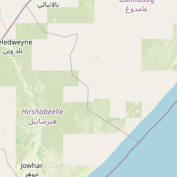
Map view of Hobyo National Park

Use this park location map to pinpoint Hobyo National Park in Somalia, understand its exact geographic position, and read its mapped placement within the surrounding landscape more clearly.

Pigeon | © OpenStreetMap contributors
Park atlas

Explore the geographic spread of coastal dune ecosystems and unique conservation landscapes in the Horn of Africa.

Discover Other Protected Areas and National Parks Near Hobyo National Park

After exploring Hobyo National Park, continue your discovery by browsing other protected areas and national parks within the surrounding Horn of Africa region. Compare diverse coastal dune ecosystems, xeric scrublands, and conservation landscapes to deepen your understanding of regional park geography.
National parkMiddle Juba
About 18 km away#1 closest

West

Jilib National Park: National Park with Mapped Protected Boundaries

Geographic context within Middle Juba.

Examine Jilib National Park as a significant protected natural area. This national park's identity is rooted in its specific geographic location within the Middle Juba region. The atlas-focused presentation details its mapped boundaries and landscape context, allowing for precise exploration of its protected status and regional significance. Understanding Jilib National Park contributes to a broader appreciation of Somalia's conservation geography.

Area
950 km²
Established
1970
IUCN
II
Visitors
300 annual
National parkLower Juba
About 698 km away#2 closest

Southwest

Kismayo National Park: Protected Landscape and National Park Identity in Lower Juba

Explore its mapped geography and regional context.

Gain insight into Kismayo National Park, designated as a National Park in Somalia. This entry provides detailed geographic information, focusing on its mapped protected area boundaries and its placement within the Lower Juba region. It serves as a foundational point for understanding the park's identity as a protected landscape and for atlas-based exploration of Somalia's natural geography.

IUCN
II
Relief
Lowland
Climate
Arid
Scope
Terrestrial
National parkMandera County
About 724 km away#3 closest

West

Malka Mari National Park: Remote Frontier Protected Landscape and Dawa River Ecosystem

Explore the semi-arid bushland and riparian woodland geography.

Malka Mari National Park offers a profound wilderness experience as Kenya's most remote national park, situated along the Dawa River in Mandera County. This protected area features striking contrasts between arid bushland and verdant riparian woodlands, supporting unique plant species and wildlife adapted to the semi-arid environment. Its vast, undeveloped character makes it a significant site for frontier conservation and a unique destination for atlas-style landscape exploration.

Area
1,500 km²
Established
1989
IUCN
II
Climate
Arid
National parkSomalia
About 724 km away#4 closest

North

Ga'an Libah National Park: A National Park's Protected Landscape and Geographic Context

Explore its mapped boundaries and regional geography.

Ga'an Libah National Park, designated as a national park, offers a distinct focus on its protected landscape and geographic identity. This resource details the mapped extent and regional context of the park, contributing to a structured understanding of its natural terrain and protected area significance. Users can explore its specific geography and atlas positioning without travel planning details.

National parkSomalia
About 854 km away#5 closest

Southwest

Bushbushle National Park: A Protected National Park in Somalia's East African Geography

Explore the mapped boundaries and conservation landscape.

Bushbushle National Park is a significant protected area situated within Somalia's diverse geography. This page provides an atlas-focused exploration of its identity as a national park, detailing its mapped geographic presence and protected landscape characteristics. Understanding Bushbushle National Park offers insight into the protected natural areas shaping the region's conservation map and broader territorial context.

IUCN
II
National parkLower Juba
About 854 km away#6 closest

Southwest

Lag Badana National Park National Park: Mapped Geography and Protected Landscape Context

Explore the distinct geographic identity of this protected national park.

Lag Badana National Park is a designated national park within the Lower Juba region, offering a focused look at protected landscapes and regional geography. This entry provides an atlas-oriented perspective on the park's mapped boundaries and its significance as a conservation area. Understand its place within the broader geographic context of Somalia through its defined park lands.

Area
3,340 km²
IUCN
II
Climate
Tropical
Scope
Mixed
National parkSomalia
About 855 km away#7 closest

Northeast

Ras Hafun National Park: Somalia's Protected Coastal Landscape and Geographic Atlas Entry

Explore mapped boundaries and regional natural landscapes.

Ras Hafun National Park serves as a focal point for understanding Somalia's protected natural areas and their geographic distribution. As a national park, it offers a distinct landscape entity to analyze within the atlas of the Horn of Africa. This MoriAtlas entry highlights the park's spatial definition and its significance as part of the country's conserved environments, providing essential context for regional geography and mapped terrain exploration.

Area
2,571 km²
Relief
Lowland
Climate
Arid
Access
Access unknown
National parkBale Zone
About 873 km away#8 closest

West

Bale Mountains National Park National Park: Explore Protected Landscape and Regional Geography

Mapped boundaries and natural terrain context for this Ethiopian park.

Delve into Bale Mountains National Park, a designated national park in Ethiopia's Bale Zone, focusing on its role as a vital protected landscape. This page offers detailed insights into the park's mapped boundaries and its contribution to the regional geography, providing a foundation for structured atlas exploration of protected areas and natural terrain. Understand the geographic significance and landscape identity of this key conservation entity within the broader context of Ethiopia's natural heritage.

Area
2,220 km²
Established
1970
IUCN
II
Relief
Mountain

Common questions about visiting, size, designation, and location context for Hobyo National Park

Hobyo National Park FAQs for park facts, access, geography, and protected area context

Find quick answers about Hobyo National Park, including protected-area facts, park geography, trail and visitor context, and how the park fits into its surrounding country and regional landscape.
MoriAtlas Explorer

Continue Your Protected Areas Search Across the Global Atlas

Deepen your exploration by continuing the structured search for national parks and protected areas worldwide. Utilize the comprehensive filtering capabilities to compare different conservation landscapes and refine your understanding of global park geography. Discover more about the distribution and characteristics of protected natural areas.

Global natural geography
