


Mori Atlas logo
Nature reserveHochwasserschutzpolder zwischen Senator-Apelt-Straße und Neustädter Hafen

Discover the geographic mosaic of flood-control infrastructure and vital riparian habitats in Bremen.

Hochwasserschutzpolder zwischen Senator-Apelt-Straße und Neustädter Hafen: A Protected Wetland Landscape

The Hochwasserschutzpolder zwischen Senator-Apelt-Straße und Neustädter Hafen functions as a critical flood-control system and a designated nature reserve within the urban landscape of Bremen. Encompassing 84.7 hectares of dike-protected floodplains, the site features a diverse mosaic of reed beds, alluvial woodland, and backwaters that support numerous wetland bird species. It serves as a vital ecological corridor, merging engineering with natural terrain to maintain biodiversity in an industrial port environment.

wetlandfloodplainpoldernature reserveImportant Bird Areabirdwatching
Digital vector-style illustration of a green meadow with a winding river leading toward distant mountains, set under a soft sunset sky with stylized clouds and trees.

Hochwasserschutzpolder zwischen Senator-Apelt-Straße und Neustädter Hafen

Nature reserve

Park overview

Structured park overview, official facts, and landscape profile for Hochwasserschutzpolder zwischen Senator-Apelt-Straße und Neustädter Hafen

Hochwasserschutzpolder zwischen Senator-Apelt-Straße und Neustädter Hafen park facts, protected area profile, and essential visitor context

Review the core facts for Hochwasserschutzpolder zwischen Senator-Apelt-Straße und Neustädter Hafen, including designation, size, terrain, visitor scale, habitats, and operating context in one park-focused overview.

About Hochwasserschutzpolder zwischen Senator-Apelt-Straße und Neustädter Hafen

The Hochwasserschutzpolder zwischen Senator-Apelt-Straße und Neustädter Hafen represents an unusual intersection of flood management and ecological conservation in Bremen. The site lies in the port neighborhood of Neustädter Hafen, tucked between active harbor facilities, the Senator-Apelt-Straße road, and the Bremen freight center. Despite this intensely urban and industrial surrounding context, the polder has become one of the city's most ecologically valuable protected natural areas.

Originally, the land was earmarked as an extension of the Neustädter Hafen, a port facility built in the early 1960s. However, after storm surge barriers (Sturmflutsperrwerke) were constructed on the Hunte, Ochtum, and Lesum tributaries of the Weser in the late 1960s and early 1970s, the expansion plans were abandoned. In 1971 the area was repurposed as a controlled flood storage basin: an area that can be deliberately flooded to ease pressure on Bremen's flood defenses while remaining diked against the Weser, with an overflow weir controlling water exchange with the river.

Today the polder's irregular but ecologically valuable flooding regime shapes its habitats. Large portions are not used for agriculture, while some sections are managed as wet grassland. The remaining area has developed into a diverse mosaic featuring alluvial forest (Auwald) and additional woodland, near-natural still waters, reed beds (Röhricht), and ruderal vegetation. This habitat diversity supports a rich community of birds, amphibians, dragonflies, and aquatic invertebrates.

The site's formal protection reflects both its rarity within Bremen and its broader significance for regional biodiversity. Listed as an Important Bird Area since 2002 and qualifying under the EU Birds Directive, the reserve sits within a small but meaningful network of protected areas in the Free Hanseatic City of Bremen. Its combination of ecological richness and continued flood-management function makes it a notable example of how infrastructure-driven landscapes can evolve into conservation assets.

Quick facts and research context for Hochwasserschutzpolder zwischen Senator-Apelt-Straße und Neustädter Hafen

The Hochwasserschutzpolder zwischen Senator-Apelt-Straße und Neustädter Hafen is a designated nature reserve (Naturschutzgebiet) in Bremen, Germany, registered as protected area number 18. It spans roughly 84.7 hectares and is managed by Bremen's Senator for Environment.

Established as a flood-control polder in 1971, it has held nature reserve status since 2 April 2014 and has been recognized as an Important Bird Area since 2002. The site borders the Neustädter Hafen port basin to the east and the Senator-Apelt-Straße plus the Bremen freight village to the west, making it a notable natural refuge within an industrial and urban setting.

Protection and recognition

Examine documented protected area metrics, baseline identifiers, and management scope details.

Hochwasserschutzpolder zwischen Senator-Apelt-Straße und Neustädter Hafen Protection Status and Designation Records

Review verified protection status records and administrative database identifiers associated with Hochwasserschutzpolder zwischen Senator-Apelt-Straße und Neustädter Hafen. Structured records compile official baseline metrics to support transparent geographic research and conservation tracking.

Protection details

WDPA ID
555588647
Park context

Deeper park guide and search-rich context for Hochwasserschutzpolder zwischen Senator-Apelt-Straße und Neustädter Hafen

Hochwasserschutzpolder zwischen Senator-Apelt-Straße und Neustädter Hafen history, landscape, wildlife, and travel context

Explore Hochwasserschutzpolder zwischen Senator-Apelt-Straße und Neustädter Hafen through its history, landscape character, ecosystems, wildlife, conservation priorities, cultural context, and seasonal travel timing in a structured park guide built for atlas discovery and search intent.

Why Hochwasserschutzpolder zwischen Senator-Apelt-Straße und Neustädter Hafen stands out

The reserve is best known for its combination of flood protection function and ecological value for wetland birds. It hosts more than 50 breeding bird species, including marsh harrier, short-eared owl, bittern, reed and great reed warbler, bluethroat, shelduck, garganey, gadwall, spotted crake, and black-necked grebe. The polder is also recognized as an Important Bird Area and qualifies for designation under the EU Birds Directive. Its mosaic of alluvial woodland, still waters, reed beds, wet meadows, and ruderal vegetation, all within the urban-industrial environment of Bremen, gives the site a distinctive identity. The interplay between engineered flood infrastructure and self-sustaining wetland habitat is a defining feature of the reserve.
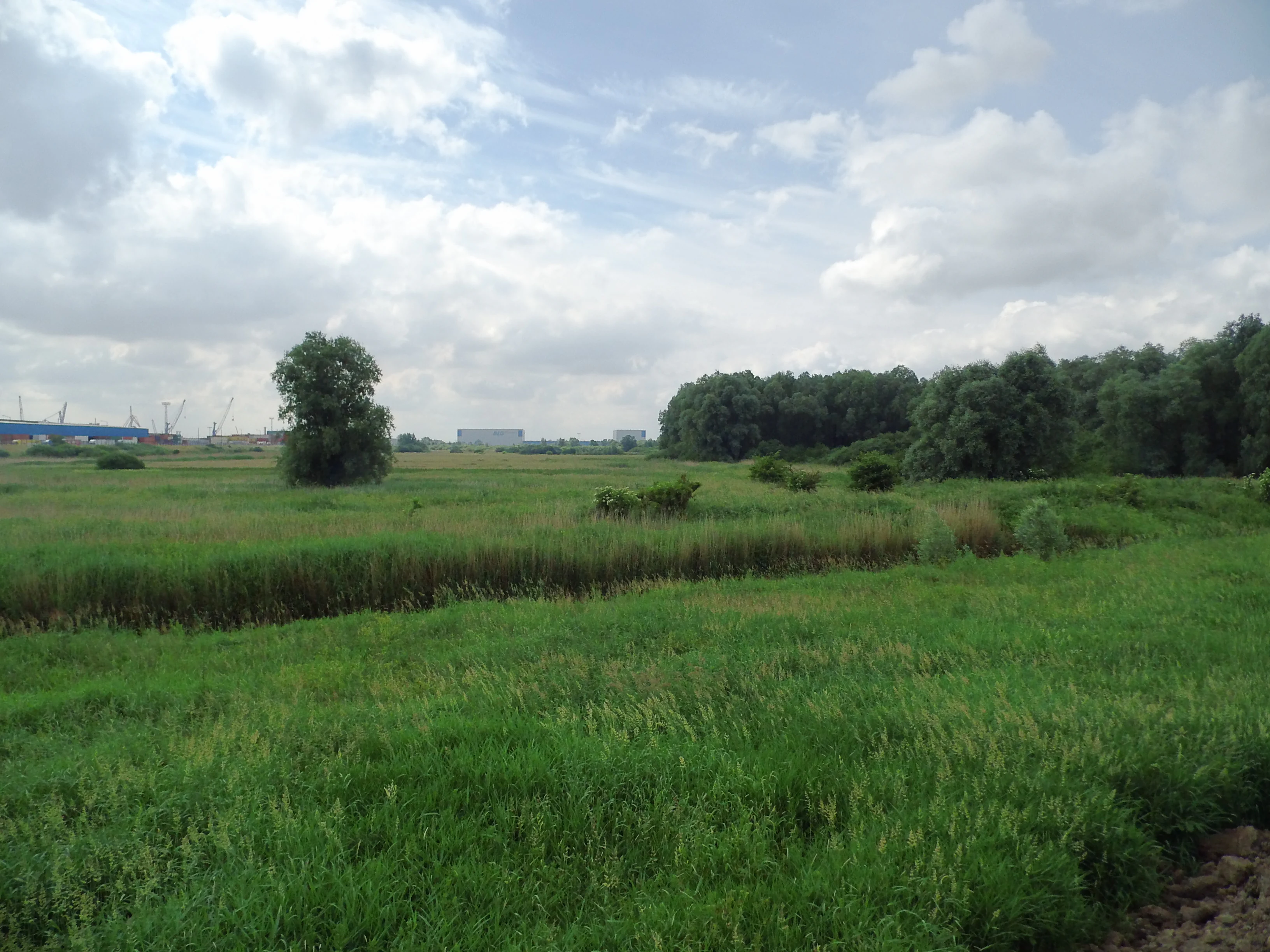
A wide-angle view of a green wetland meadow with scattered trees and shrubs, showing distant port facility buildings under a cloudy sky.
The Hochwasserschutzpolder between Senator-Apelt-Straße and Neustädter Hafen, featuring open grasslands and distant industrial architecture.

Hochwasserschutzpolder zwischen Senator-Apelt-Straße und Neustädter Hafen history and protected-area timeline

The site's origins date back to the early 1960s, when the Neustädter Hafen was constructed and the adjacent polder area was reserved as a future port expansion zone. After storm surge barriers were completed on the Hunte, Ochtum, and Lesum, tributaries feeding into the Lower Weser, the planned harbor expansion was no longer considered necessary. In 1971 the area was formally redesignated as a flood-control polder, equipped with dikes and an overflow weir to safely exchange water with the Weser during high-water events.

For decades the polder functioned primarily as a piece of flood-protection infrastructure, but its ecological value gradually became apparent. In 2002 it was formally recognized as an Important Bird Area, acknowledging its significance for breeding and migratory waterbirds. This recognition paved the way for stronger conservation status, and on 2 April 2014 the area was officially designated as a nature reserve under Bremen's protected areas register, where it is listed as number 18.

The reserve is administered by the Senator for Environment, Building and Transport, reflecting its dual role as both a flood defense element and a protected natural site. Today it stands as a mature example of how a former industrial expansion site can transition into a recognized area of ecological importance.

Hochwasserschutzpolder zwischen Senator-Apelt-Straße und Neustädter Hafen landscape and geographic character

The polder occupies a roughly flat, low-lying floodplain immediately west of the Neustädter Hafen harbor basin. It is bounded on the east by the active port infrastructure, on the west by the Senator-Apelt-Straße and the Bremen freight center (Güterverkehrszentrum), and on its southern side by the diked margin of the Weser. The landscape is shaped by its controlled flooding role, with most of the terrain lying within a dike-protected zone accessed by an overflow weir.

Within this framework, the surface features a highly varied mosaic. Still waters sit among sections of alluvial woodland and additional shrub and tree cover. Reed beds (Röhricht) line the water margins, while wet meadows occupy parts of the polder that are still subject to light agricultural use. Other areas have developed into ruderal vegetation, giving the site a textured, semi-wild appearance despite its context within the urban port district of Bremen.

Hochwasserschutzpolder zwischen Senator-Apelt-Straße und Neustädter Hafen ecosystems, habitats, and plant life

Ecologically, the Hochwasserschutzpolder is dominated by wetland and near-natural freshwater habitats. Its still waters, reed beds, wet meadows, and alluvial woodland form a connected habitat mosaic that supports a wide range of flora and fauna typical of temperate European river floodplains.

Plant communities include stands of white willow, yellow flag iris, purple loosestrife, flowering rush (Schwanenblume), and water-purslane. The combination of open water, marsh vegetation, and damp woodland edge produces habitat layering that benefits insects, amphibians, and birds alike.

The reserve's hydrology is the ecological engine: irregular flooding from the Weser replenishes the still waters, maintains the wet meadow character, and supports the soft sediment and reed conditions that drive the site's species diversity.

Hochwasserschutzpolder zwischen Senator-Apelt-Straße und Neustädter Hafen wildlife and species highlights

The reserve's central ecological importance is for birds. More than 50 breeding bird species have been documented here, including marsh harrier, short-eared owl, bittern, sedge warbler, great reed warbler, bluethroat, shelduck, garganey, gadwall, spotted crake, and black-necked grebe. The site also functions as a significant resting and stopover area for migratory birds, drawing from the broader Weser corridor.

Beyond the avifauna, the still waters and wet meadows host a notable amphibian and dragonfly fauna. Species recorded include the small mosaic dragonfly (Kleine Mosaikjungfer) and the spotted darter (Gefleckter Heidelibelle), both indicators of high-quality freshwater habitat. Invertebrate diversity is further reflected in the presence of the large pond mussel (Große Teichmuschel) and the small water scavenger beetle (Kleiner Kolbenwasserkäfer), the latter of which is of particular conservation interest in northern Germany.

Together, these assemblages make the polder a compact but disproportionately rich wildlife refuge within Bremen's otherwise heavily built-up port landscape.

Hochwasserschutzpolder zwischen Senator-Apelt-Straße und Neustädter Hafen conservation status and protection priorities

Conservation-wise the polder is a regionally significant example of a former industrial expansion site transformed into formally protected habitat. Its recognition as an Important Bird Area in 2002 and its qualification under the EU Birds Directive confirm its importance for breeding and migratory waterbird populations. Formal designation as a Bremische nature reserve in 2014 cemented its protected status under local law.

The site's value is heightened by its position within a heavily modified urban-industrial matrix. The floodplain's reed beds, still waters, and woodland provide resources that are scarce elsewhere in the city. The reserve also supports several protected or locally notable invertebrate species, including the small water scavenger beetle, contributing to broader regional biodiversity objectives.

Continued management by the Senator for Environment, Building and Transport balances the polder's ongoing flood-protection role with the maintenance of its ecological character.

Top sights and standout views in Hochwasserschutzpolder zwischen Senator-Apelt-Straße und Neustädter Hafen

The polder combines engineered flood storage with mature wetland habitat, providing Bremen with a functioning flood buffer and an ecologically valuable nature reserve at the same time. Its 50-plus breeding bird species and Important Bird Area status make it one of Bremen's most bird-rich protected sites. The reserve also harbors locally notable invertebrates such as the small water scavenger beetle and the large pond mussel, extending its conservation value beyond birds alone.


Monthly climate preview

Long-term representative monthly temperature and precipitation rhythm in Bremen

Hochwasserschutzpolder zwischen Senator-Apelt-Straße und Neustädter Hafen Climate Normals

Representative coordinates record annual temperature progression alongside steady baseline precipitation rates across twelve months. Exploring the full monthly dataset reveals detailed variations in baseline averages for this protected location.
Annual mean9 °C
1 °C18 °C
Jan
Feb
Mar
Apr
May13°
Jun16°
Jul18°
Aug18°
Sep14°
Oct10°
Nov
Dec
Warmest month
July

18 °C

Coolest month
January

1 °C

Wettest month
July

2.5 mm/day

Driest month
April

1.4 mm/day

Park location guide

Geography guide, regional context, and park location map for Hochwasserschutzpolder zwischen Senator-Apelt-Straße und Neustädter Hafen

Hochwasserschutzpolder zwischen Senator-Apelt-Straße und Neustädter Hafen park geography, regions, and map view in Germany

Understand where Hochwasserschutzpolder zwischen Senator-Apelt-Straße und Neustädter Hafen sits in Germany through a broader geographic reading of the surrounding landscape, nearby location context, and its mapped position within the national park landscape.

How Hochwasserschutzpolder zwischen Senator-Apelt-Straße und Neustädter Hafen fits into Germany

Germany is a federal republic in Western and Central Europe with a population of over 83 million across sixteen constituent states. It is Europe's largest economy by nominal GDP and a major global exporter and importer. The capital is Berlin, and the country borders Denmark, Poland, Czech Republic, Austria, Switzerland, France, Luxembourg, Belgium, and the Netherlands.

Wider geography shaping Hochwasserschutzpolder zwischen Senator-Apelt-Straße und Neustädter Hafen in Germany

Germany is located in Western and Central Europe, spanning 357,022 km². It borders Denmark to the north, Poland and the Czech Republic to the east, Austria and Switzerland to the south, and France, Luxembourg, Belgium, and the Netherlands to the west. The country has coastlines on the Baltic Sea and North Sea to the north, with the Alps located in the southern region.

Map view of Hochwasserschutzpolder zwischen Senator-Apelt-Straße und Neustädter Hafen

Use this park location map to pinpoint Hochwasserschutzpolder zwischen Senator-Apelt-Straße und Neustädter Hafen in Germany, understand its exact geographic position, and read its mapped placement within the surrounding landscape more clearly.

Pigeon | © OpenStreetMap contributors

Location context for Hochwasserschutzpolder zwischen Senator-Apelt-Straße und Neustädter Hafen

Bremen

Visualizing the wetland habitats, dike floodplains, and protected scenery of Bremen

Hochwasserschutzpolder zwischen Senator-Apelt-Straße und Neustädter Hafen Photos and Landscape Views

Photographic collections reveal the complex terrain, quiet backwaters, and alluvial woodland mosaics that define the protected reserve. Visual documentation captures how engineered flood infrastructure and thriving wetland habitats coexist within the urban port district.

A wide-angle view of a green wetland meadow with scattered trees and shrubs, showing distant port facility buildings under a cloudy sky.

Park atlas

Compare regional protected areas and wetland habitats across Bremen

Parks Near Hochwasserschutzpolder zwischen Senator-Apelt-Straße und Neustädter Hafen

Browse protected areas and wetland habitats located near Hochwasserschutzpolder zwischen Senator-Apelt-Straße und Neustädter Hafen to expand regional conservation context. Comparing nearby reserves helps trace riparian ecosystems and floodplain networks across the surrounding urban landscape.
Nature reserveBremen
About 3.1 km away#1 closest

South

Ochtumniederung bei Brokhuchting: Wetland Nature Reserve and Floodplain Geography

A core conservation area within the Bremen Niedervieland

This protected area stands as a primary example of large-scale river floodplain restoration in the Bremen region. The landscape includes a dense network of canals, reedbeds, and seasonal flood zones that provide critical shelter for waterfowl and waders. Through careful environmental management, this site integrates natural riverine terrain with the surrounding industrial and urban framework of northwestern Germany, offering a distinct study of managed wetland ecosystems.

Area
3.75 km²
Established
1998
Relief
Lowland
Climate
Temperate
A horizontal watercolor painting showing a tranquil lake scene with green trees, low-lying hills in the distance, and grassy banks against a white background.
Nature reserveBremen
About 5.9 km away#2 closest

North

Grambker Feldmarksee Nature Reserve: Mapping the Protected Landscapes of Bremen

A vital wetland sanctuary shaped by regional infrastructure and natural restoration

Grambker Feldmarksee offers a focused look at how post-industrial quarry sites evolve into ecologically dense nature reserves. This groundwater-fed lake in Bremen acts as a green island, showcasing mature woodland fringes and specialized wetland habitats that are integral to the local bird protection network.

Area
0.226 km²
Established
2009
Relief
Lowland
Climate
Temperate
Nature reserveBremen
About 7.4 km away#3 closest

Northeast

Untere Wümme Nature Reserve: Riverine Biodiversity and Protected Tidal Landscapes in Bremen

Protected floodplain geography and tidal river habitats.

This nature reserve protects the meandering lower course of the Wümme river, showcasing one of northern Germany's few freshwater tidal systems. Spanning reedbeds, willow forests, and open mudflats, the reserve forms a vital corridor for migratory fish and waterfowl, reflecting a complex mosaic of protected riverine ecosystems and historic meadow landscapes.

Area
1.485 km²
Established
1991
Relief
Lowland
Climate
Temperate
A watercolor painting showing a serene landscape with calm water, small islands of trees, and rolling hills in the background.
Nature reserveBremen
About 7.5 km away#4 closest

East

Am Stadtwaldsee (Uni-Wildnis) Nature Reserve: Geographic Atlas and Park Map Context

Protected secondary habitat landscape in Bremen, Germany

Located in Bremen, the Am Stadtwaldsee (Uni-Wildnis) nature reserve offers a compelling study of secondary ecological succession. The area features a dense concentration of ponds and wooded ground shaped by historical sand mining. Explore the mapped boundaries of this eleven-hectare refuge to understand its role in urban biodiversity and regional landscape conservation.

Area
0.114 km²
Established
1991
IUCN
IV
Nature reserveBremen
About 7.5 km away#5 closest

East

Kuhgrabensee Nature Reserve: Mapped Geography and Protected Areas in Bremen

An ecologically vital lake and bird sanctuary in Northwest Germany

Kuhgrabensee serves as a prime example of landscape restoration within Bremen, featuring a groundwater-fed lake with notable saline influences. This protected area supports a diverse array of pioneer plants and wildlife across its reed-lined shores and shallow-water habitats, providing a quiet corridor for ecological observation and study in the heart of the local landscape.

Area
0.296 km²
Established
1987
Relief
Lowland
Climate
Temperate
Nature reserveBremen
About 7.7 km away#6 closest

Northwest

Dunger See Nature Reserve: Mapped Protected Wetland and Landscape Geography in Bremen

A structured geographic look at the Werderland bird protection habitat.

Dunger See is a compact, ecologically diverse nature reserve in Bremen, shaped by intentional land management to provide critical nesting and wintering grounds for wildfowl. This protected area stands out for its indented shoreline, artificial island clusters, and surrounding woodland buffers that contrast with the open agricultural terrain of the wider Werderland landscape.

Area
0.33 km²
Established
1990
Relief
Lowland
Climate
Temperate
A soft, painterly watercolor illustration depicting a winding river through a flat green meadow with rolling hills in the background.
Nature reserveBremen
About 8.3 km away#7 closest

East

Hollerland Nature Reserve: A Protected Cultural Landscape and Wetland in Bremen

Historic marshland terrain with unique saline spring ecosystems

Hollerland is a 293-hectare nature reserve in Bremen, Germany, notable for its well-preserved cultural landscape of wet grasslands and an intricate medieval ditch network. This protected area serves as a critical breeding ground for meadow birds and hosts an ecologically significant inland saline spring, providing a rare habitat for brackish-adapted plant communities deep within the regional landscape.

Area
2.93 km²
Established
1985
IUCN
IV
Relief
Lowland
Nature reserveBremen
About 9.4 km away#8 closest

North

Ruschdahlmoor Nature Reserve: Deep Peatlands and Protected Wetland Geography in Bremen

Geological subsidence sinkhole and urban protected landscape

Ruschdahlmoor stands as a unique nature reserve in Bremen, Germany, distinguished by a peat-forming wetland developed inside a sinkhole over the Lesum salt dome. This protected area supports tall herb meadows, reed-fringed ponds, and rare peat-depth records, offering a dense, ecologically rich landscape context that remains a vital part of the city's natural geography.

Area
0.048 km²
Established
1991
IUCN
IV
Relief
Lowland

Common questions about visiting, size, designation, and location context for Hochwasserschutzpolder zwischen Senator-Apelt-Straße und Neustädter Hafen

Hochwasserschutzpolder zwischen Senator-Apelt-Straße und Neustädter Hafen FAQs for park facts, access, geography, and protected area context

Find quick answers about Hochwasserschutzpolder zwischen Senator-Apelt-Straße und Neustädter Hafen, including protected-area facts, park geography, trail and visitor context, and how the park fits into its surrounding country and regional landscape.
MoriAtlas Explorer

Continue Your Protected Areas Search Across the Global Atlas

Deepen your exploration by continuing the structured search for national parks and protected areas worldwide. Utilize the comprehensive filtering capabilities to compare different conservation landscapes and refine your understanding of global park geography. Discover more about the distribution and characteristics of protected natural areas.

Global natural geography


