

Why Ruschdahlmoor stands out
Ruschdahlmoor is best known for its extraordinary peat depth, exceeding 33 meters; a depth that places it among the deepest peatlands in Europe. This unusual thickness is the result of the peat having accumulated in a subsidence sinkhole (Erdfalltrichter) above the Lesum salt dome, where ground movement created a depression that gradually filled with organic material. The reserve is also known as an ecologically rich wetland island within an otherwise urbanized part of northern Bremen, where tall herb meadows, reedbeds, and sedge marshes persist within a residential landscape.
Ruschdahlmoor history and protected-area timeline
Ruschdahlmoor was officially placed under nature protection on 8 October 1991, becoming the 12th protected area registered in Bremen's nature reserve book. The designation came decades after the area had already been recognized locally as an exceptional peatland, owing to its unusual depth and its formation within a subsidence feature above the Lesum salt dome.
The authority responsible for the reserve is Die Senatorin für Umwelt, Klima und Wissenschaft; Bremen’s Senator for Environment, Climate and Science, which oversees monitoring, habitat management, and public access within the site. The 1991 designation formalized legal protection for a wetland complex that had developed through long-term natural processes rather than recent land-use change.
Since its designation, Ruschdahlmoor has remained a small but consistently recognized element of Bremen's network of nature reserves, listed alongside larger wetland and riverine protected areas such as Borgfelder Wümmewiesen, Werderland, and the Untere Wümme; though on a very different, much more compact scale.
Ruschdahlmoor landscape and geographic character
Ruschdahlmoor lies within the Vegesacker Geest, a sandy upland region on the northern edge of Bremen. This geest area is characterized by glacial-era sandy soils, gently undulating terrain, and patches of wetland where groundwater reaches the surface. Within this setting, the Ruschdahlmoor reserve occupies a localized depression, a subsidence cone roughly matching the outline of the Lesum salt dome's undermined cap rock.
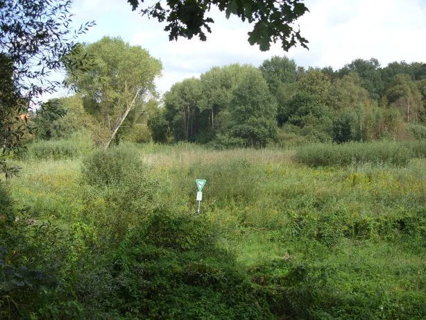
The surface landscape is shaped entirely by wetland processes. The reserve contains a network of small open water bodies, slow-moving peatland channels, reed-fringed pools, and wet meadows. Vegetation transitions from open water at the deepest points to sedge marshes, reedbeds, tall herb vegetation, and patches of scrub around the margins. Even the surrounding narrow landscape-protection strips contribute visual and ecological structure, buffering the reserve from the dense residential fabric that otherwise dominates the area.
Drainage from the reserve flows via the Ihle into the Lesum river, integrating the local wetland into the wider Lesum catchment. The peat itself, exceeding 33 meters in thickness, constitutes the defining landscape feature: a deep column of partly decomposed plant material that has accumulated within the sinkhole over thousands of years.
Ruschdahlmoor ecosystems, habitats, and plant life
The ecological character of Ruschdahlmoor centers on its functioning peatland hydrology and the resulting habitat mosaic. The reserve hosts reedbeds (Röhrichte), sedge communities (Seggenrieder), and tall herb meadows (Hochstaudenfluren), intersected by ponds and small streams. Scrub patches add structural diversity, and the margins transition gently into adjacent landscape protection zones.
This dense concentration of different wetland vegetation types within a few hectares supports the ecological value of the site considerably. Peat-forming processes are still active, meaning the reserve continues to accumulate organic material and contributes to long-term carbon storage, an increasingly important ecological function of intact peatlands.
The reserve's location within an urban matrix makes its ecological function particularly notable: it acts as a biodiversity refuge for wetland species that would otherwise be displaced by housing, roads, and infrastructure. Its hydrological connection to the Lesum river via the Ihle stream also means it contributes to the broader water quality and habitat continuity of the wider Bremen wetland system.
Ruschdahlmoor wildlife and species highlights
While the available source material for Ruschdahlmoor does not provide specific species inventories, the reserve's habitat composition strongly suggests presence of wetland-associated fauna. Reedbeds and sedge marshes typically support diverse amphibian populations, dragonflies, and aquatic invertebrates, while tall herb communities provide shelter and foraging habitat for small mammals and a range of bird species. The small ponds within the reserve, combined with its scrub patches, offer additional structural variety for wildlife.
Given the reserve's ecological role within an urban landscape, its wildlife value lies less in rare species records and more in its function as a persistent refugium within a heavily built-up environment. Wetland reserves embedded in cities like Bremen often serve as important breeding, feeding, and resting habitats for amphibians and birds that have lost much of the surrounding countryside to development.
Ruschdahlmoor conservation status and protection priorities
Ruschdahlmoor has been protected as a Bremen state nature reserve since 8 October 1991, with responsibility assigned to Bremen's environmental authority. It is recorded under IUCN Category IV, a Habitat/Species Management Area, reflecting its role in conserving specific habitats and species rather than functioning primarily as a strict wilderness reserve. Its small size, ecological richness, and geological peculiarity give it disproportionate conservation significance within the broader Bremen protected-area network.
The reserve's main conservation value lies in the preservation of an intact peat-forming system. Active peat accumulation, rare within urban areas, contributes to long-term carbon storage and demonstrates the ecological importance of preserving hydrology, water quality, and vegetation cover at the site. The narrow landscape-protection strips surrounding the reserve also play a buffering role, reducing disturbance from adjacent housing and supporting a gradual ecological gradient between the protected core and its built environment.
By protecting an active peat body within a sinkhole above a salt structure, the designation of Ruschdahlmoor safeguards not only biological diversity but also a regionally significant geological and hydrological feature. The reserve is an important example of how even very small protected areas can hold disproportionate geological and ecological value.
Top sights and standout views in Ruschdahlmoor
Among the standout qualities of Ruschdahlmoor is its extraordinary peat depth, exceeding 33 meters and placing the site among the deepest peatlands documented in Europe. Its formation within a subsidence cone above the Lesum salt dome gives the reserve a uniquely documented geological origin.
A second defining highlight is the reserve's setting: a functioning wetland, complete with reedbeds, sedge marshes, ponds, and streams, within a landscape almost entirely enclosed by housing. The presence of boardwalk-protected paths shows how even such a compact, urban-edge reserve can offer accessible, low-impact engagement with peatland ecology. Together, these qualities make Ruschdahlmoor one of Bremen's most distinctive, if understated, protected areas.
Best time to visit Ruschdahlmoor
As a small urban-edge wetland, Ruschdahlmoor can be visited throughout the year, though late spring and summer are typically the most rewarding seasons. During these months the reedbeds, sedge marshes, and tall herb meadows are in full growth, and wetland wildlife such as dragonflies, amphibians, and wetland-associated birds is most active. Autumn and winter visits can emphasize the reserve's quieter, more subdued character, with the leafless scrub offering clearer views of the pond network and the surrounding residential landscape. Comfortable waterproof footwear is advisable in any season, as the boardwalk-reinforced paths can still cross damp peatland terrain.





