
Mori Atlas logo
Nature reserveHolzmaar

A sheltered, forest-fringed maar lake forming an essential climate archive within the Vulkaneifel region.

Holzmaar Nature Reserve: Volcanic Crater Landscapes and Paleoclimate Geography in Rhineland-Palatinate

Holzmaar is a small, circular volcanic maar located in the Vulkaneifel of Rhineland-Palatinate. As a protected nature reserve, this site is internationally recognized for its annually laminated lake sediments that preserve a 23,000-year paleoclimate record. The terrain features a forest-encircled basin and wetland shore zones, shaped by Quaternary volcanism and continuously refreshed by the Sammetbach stream.

maarvolcanic lakecrater lakepaleoclimate archivevarved sedimentslake sediments
A graphic illustration of a valley between rocky hillsides, featuring a winding river, evergreen trees in the foreground, and a pale sun in a pastel sky.

Holzmaar

Nature reserve

Park overview

Structured park overview, official facts, and landscape profile for Holzmaar

Holzmaar park facts, protected area profile, and essential visitor context

Review the core facts for Holzmaar, including designation, size, terrain, visitor scale, habitats, and operating context in one park-focused overview.

About Holzmaar

Holzmaar is a small maar lake in the heart of the Vulkaneifel, one of the central European volcanic fields most strongly associated with maar-type craters. Like other maars of the region, it formed through a phreatomagmatic eruption, in which rising magma encountered groundwater and produced a violent explosion that excavated a broad, shallow crater. Over time, the crater filled with water, accumulated sediments, and gradually evolved into the lake seen today. The Eifel region contains dozens of such maars, but Holzmaar stands apart because of the exceptional quality of its sediment record rather than its size or scenic fame.

The lake sits almost exactly halfway between Gillenfeld and Eckfeld, and its basin is encircled by woodland that gives the site a sheltered, secluded feel. A source stream, a headwater of the Sammetbach, flows through the maar, sustaining both the lake level and a soft shoreline environment of reeds and wet meadows. In immediate proximity lies the Dürres Maar, with which Holzmaar is often discussed as a paired feature, since together they illustrate different stages of maar evolution, from open water to partially infilled basin.

Geologically, the maar belongs to the Quaternary volcanism of the Eifel, and its surroundings still bear the subdued landforms typical of older volcanic craters filled in by erosion and sedimentation. Although the lake itself is modest in size, the surrounding nature reserve protects not only the open water but also the wetland fringes and the forest that girdles the crater. This combination of crater, shore habitat, and surrounding woodland gives Holzmaar a tightly defined ecological footprint, where aquatic, wetland, and forest communities meet within a small radius.

Scientifically, the lake became a focus of international Quaternary research because its sediments are finely laminated, with each year depositing a discernible layer, or varve, on the lake floor. These layers contain pollen, dust particles, and other environmental indicators that together build a year-by-year climate record. The Holzmaar record has been used to identify dry, dust-rich phases that may correlate with the advance of the northern European inland ice, offering a potential bridge between Alpine and northern European glacial chronologies and the timing of terminal moraines in northern Germany. Because of this, Holzmaar features prominently in the international literature on late-Pleistocene and Holocene climate history, alongside sites such as Meerfelder Maar, Lake C2 in Canada's Northwest Territories, and Lago Grande di Monticchio in southern Italy.

Quick facts and research context for Holzmaar

Holzmaar is a maar lake, a crater lake formed by a phreatomagmatic volcanic explosion when rising magma met groundwater, located in the Vulkaneifel volcanic field of Rhineland-Palatinate, Germany. It lies in a nature reserve (Naturschutzgebiet) and is nearly fully encircled by woodland, with the nearest settlement being Gillenfeld roughly 2.5 kilometers to the southwest.

The lake is small, on the order of a few hectares in surface area, with a depth of around 20 meters, and is fed by a source stream of the Sammetbach that crosses the maar basin. Its sediment record, extending back roughly 23,000 years, has made it a benchmark site for late-glacial climate studies, especially through comparison with the Meerfelder Maar chronology and Greenland ice core projects.

Protection and recognition

Terrestrial protected area framework and international recognition details

Holzmaar Protection Status and Documented Conservation Scope

Terrestrial conservation frameworks define the documented protection status and management scope established for Holzmaar. Systematic records outline official designation history and territorial governance without external assumptions.

Protection details

Protection scope
Terrestrial
Transboundary protection
No
Park context

Deeper park guide and search-rich context for Holzmaar

Holzmaar history, landscape, wildlife, and travel context

Explore Holzmaar through its history, landscape character, ecosystems, wildlife, conservation priorities, cultural context, and seasonal travel timing in a structured park guide built for atlas discovery and search intent.

Why Holzmaar stands out

Holzmaar is best known internationally as a paleoclimate reference site, because its annually laminated lake sediments preserve one of the longest and most complete late-glacial climate archives in central Europe. The layered deposits, studied through varve chronology and drill cores, reach back approximately 23,220 calendar years before present and have been used to date dust input events linked to distant glacial advances. The lake's varve record has been cross-checked against the nearby Meerfelder Maar sequence and the major Greenland ice cores, including GISP2 and GRIP, helping researchers align European terrestrial climate signals with North Atlantic ice core chronologies. In addition to its scientific importance, Holzmaar is also appreciated as a quiet, forest-enclosed maar lake within the Vulkaneifel, far less developed for tourism than the better-known Dauner Maare.
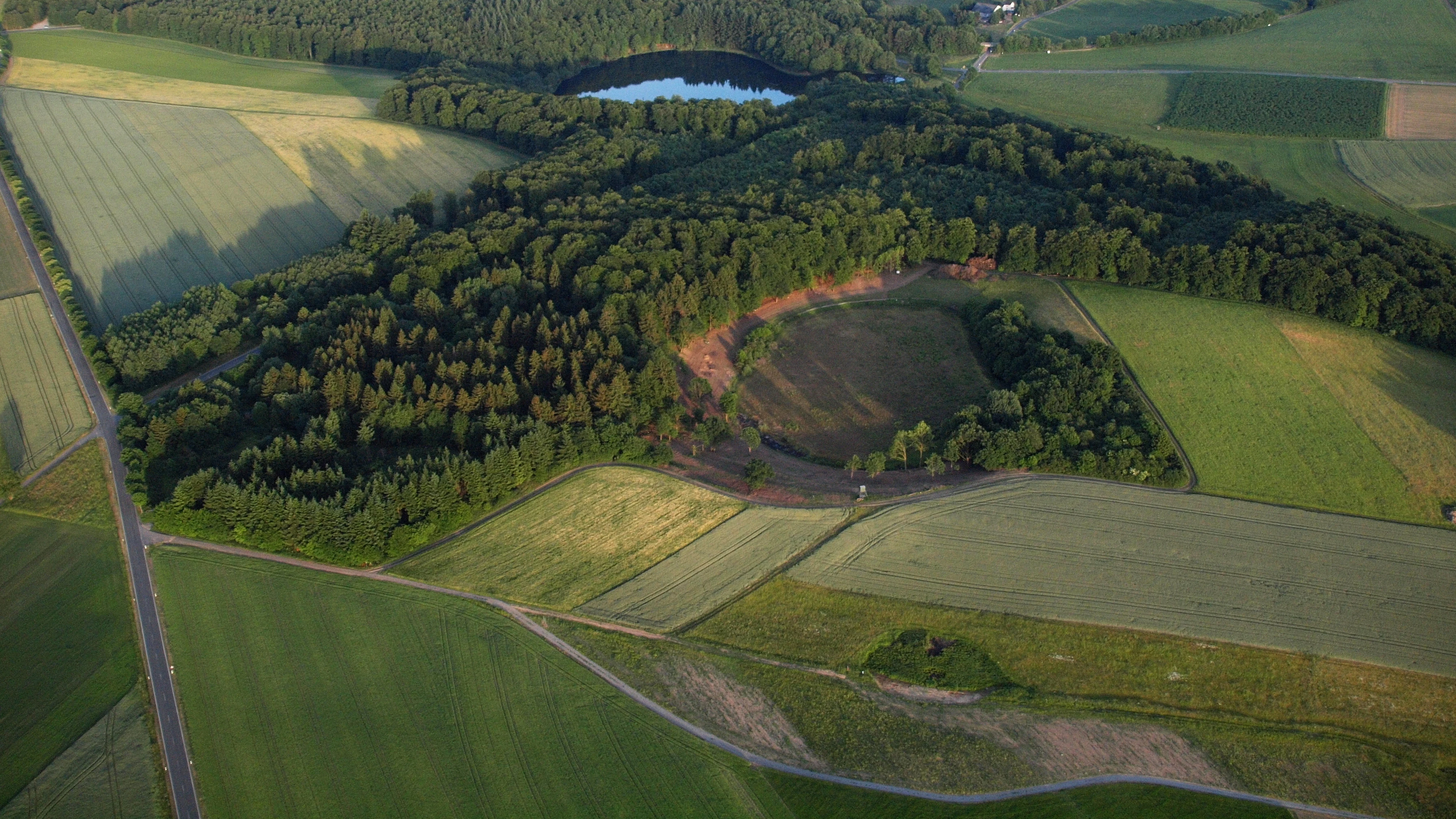
An aerial view of lush green landscapes showing three distinct volcanic maar craters, including Holzmaar lake, surrounded by fields and patches of forest.
Aerial view of the volcanic maar lakes in the Vulkaneifel region.

Holzmaar history and protected-area timeline

Holzmaar's own long history is, in a sense, its geological one: it began as a phreatomagmatic explosion during the Quaternary volcanism of the Eifel, a process that excavated the crater which would later fill with water. Over thousands of years, organic and mineral sediments accumulated on the lake floor, building the laminated sequence that today forms one of Europe's most valuable natural climate archives. The sedimentary record recovered from drill cores extends back roughly 23,220 calendar years before present, anchoring the lake's scientific history deep in the last glacial period.

In modern administrative terms, the lake and its immediate surroundings were placed under formal nature protection as a Naturschutzgebiet, recognizing both the wetland habitat and the geological significance of the basin. The protected status links Holzmaar into a broader network of Eifel nature reserves, including nearby Meerfelder Maar and the various protected landscapes of the Vulkaneifel district. From the late twentieth century onward, the lake became a recurring reference site in European paleoclimate literature, with detailed comparative studies alongside Meerfelder Maar and Greenland ice core projects such as GISP2 and GRIP shaping its reputation in Quaternary science.

Beyond the scientific record, the Holzmaar area also enters regional cultural and educational narratives of the Vulkaneifel, where maars are framed as both natural monuments and windows into deep time. While there is little documented history of human settlement directly on the lake, the surrounding villages of Gillenfeld, Eckfeld, and nearby communities have long been associated with the maar landscape, and the broader Vulkaneifel is promoted today through the Deutsche Vulkanstraße, a themed route linking volcanic and geological sites across the region.

Holzmaar landscape and geographic character

The landscape of Holzmaar is defined by the smooth, rounded basin of an old volcanic crater, softened by forest cover and by the slow infilling of sediments along its southwestern shore. The crater rim is gentle rather than dramatic, typical of older Eifel maars where erosion and vegetation have muted the original explosion scar. Where the rim breaks into the surrounding terrain, the eye reaches a continuous spread of mixed woodland that closes in around the water.

The lake itself is small but unmistakable: a roughly 325-meter-wide, circular body of water lying in a shallow bowl. A source stream of the Sammetbach enters the basin and crosses it, creating a through-flowing system that distinguishes Holzmaar from purely rain- or groundwater-fed Eifel maars. Along the southern and southwestern shore, sediments have gradually built up, partially terrestrializing the original lake margin and creating a soft, marshy transition zone between open water and forest.

The wider landscape context is the Vulkaneifel itself, a region of rolling hills, scattered maar lakes, cinder cones, and pyroclastic deposits left by Quaternary eruptions. Holzmaar sits among this volcanic backdrop alongside other named maars such as the Dürres Maar, the Meerfelder Maar, and the Dauner Maare group, all of which contribute to the region's distinctive crater-lake topography. The combination of crater basin, encircling forest, marshy shore, and through-flowing stream gives Holzmaar a layered landscape in which geology, hydrology, and vegetation converge within a small footprint.

Holzmaar ecosystems, habitats, and plant life

Ecologically, Holzmaar is a compact wetland-forest complex built around a volcanic lake. The lake is the ecological core, fed by a headwater of the Sammetbach and fringed by soft sediments that give way to marsh and reed communities typical of infilling maar margins. These shore zones are particularly valuable because they host wetland plants, invertebrates, and breeding habitat for waterbirds, all within a very limited area.

Surrounding the water, mixed deciduous and coniferous woodland climbs the crater walls and continues beyond the rim, providing a near-complete forest buffer. The continuous canopy not only shades the shoreline but also reduces nutrient input and disturbance, supporting the characteristically clear and relatively undisturbed water that makes the lake suitable for undisturbed sediment accumulation. The integration of forest and wetland around a small open water body yields a high habitat diversity for such a small site.

Woodland, marsh, and open water meet here within a few hundred meters, allowing ecological gradients to compress into a small space. This combination of aquatic, semi-aquatic, and terrestrial habitats, set within a protected basin, gives Holzmaar a disproportionately rich ecological profile for its surface area, while the surrounding Vulkaneifel adds regional context through its other maar lake and forest reserves.

Holzmaar wildlife and species highlights

Wildlife at Holzmaar is shaped by the lake's role as a quiet, forest-sheltered wetland. The reed-fringed southern shore provides breeding and feeding habitat for a range of waterbirds, including typical European wetland species that favor small, sheltered lakes with rich margins. Ducks, coots, and rails are characteristic visitors, while the surrounding woodland attracts typical central European forest bird assemblages.

The forest encircling the maar supports the full range of woodland species associated with the Vulkaneifel, including small mammals such as red squirrels, and larger forest-dwelling mammals such as roe deer, which move between the crater rim and the broader woodland matrix. Amphibians benefit from the combination of standing water, marshy shore, and adjacent forest, using the lake and its fringes for breeding while foraging in the surrounding trees.

Insect life, both above the water and within the littoral zone, is an important but quieter part of the Holzmaar ecosystem. Dragonflies and damselflies hunt over the open water and reed beds, while the lake's sediments host the meiofauna and microbial communities whose remains, alongside pollen and mineral dust, make up the laminated layers so important to paleoclimate researchers studying the site.

Holzmaar conservation status and protection priorities

Holzmaar is protected as a Naturschutzgebiet, a formal nature reserve under German conservation law, recognizing both its ecological value and its geological significance. The nature reserve designation covers the lake and its immediate surrounding land, ensuring that the wetland fringe and the encircling forest remain buffered against incompatible land use, forestry intensification, or shoreline development. This protection is particularly important because the same undisturbed conditions that sustain the habitat are exactly those that allowed the lake's sediment archive to accumulate continuously over thousands of years.

The lake sits within a much wider network of protected sites in the Vulkaneifel, including nearby Meerfelder Maar, Dürres Maar, the Dauner Maare complex, and a series of forest and meadow reserves across both the Bernkastel-Wittlich and Vulkaneifel districts. Holzmaar's conservation role therefore extends beyond its own boundaries, contributing to a regional network of wetland and forest reserves that maintains connectivity across the Eifel volcanic landscape.

From an Earth-science conservation perspective, Holzmaar is also highly significant. Its paleoclimate archive is a non-renewable resource, since the laminated sequence records an irreplaceable record of late-glacial environmental change. The protection of the lake basin, the surrounding forest that limits erosion and disturbance, and the undisturbed nature of the sediments together ensure that this archive continues to be available to Quaternary science for future research.

Holzmaar cultural meaning and human context

Holzmaar is a quiet but meaningful element of the broader Vulkaneifel cultural landscape, where maars are woven into regional identity as natural monuments and landmarks. Local folklore and regional traditions around the Eifel often treat the maar lakes as storied places, and the surrounding villages of Gillenfeld and Eckfeld have long histories shaped by their proximity to these crater lakes. Outdoor recreation, nature education, and quiet tourism are central to the cultural framing of the area, with the Vulkaneifel promoted through initiatives such as the Deutsche Vulkanstraße, which links the region's volcanic and geological sites into a coherent route.

The scientific history of Holzmaar has also become part of the regional cultural narrative, with the lake featured prominently in German and international paleoclimate literature since the late twentieth century. Researchers such as Bernd Zolitschka and colleagues have used the Holzmaar record in comparative studies with sites as far apart as the Canadian Arctic and southern Italy, embedding the lake in global discussions of late-glacial climate. While Holzmaar itself is far less touristic than the Dauner Maare, its name carries weight within specialist communities concerned with Quaternary stratigraphy, varve chronology, and the dating of European glacial deposits.

For the immediate communities around the maar, the lake continues to be a quiet reference point, both ecologically and as a piece of the local volcanic heritage, valued more for its natural quiet than for mass visitor appeal.

Top sights and standout views in Holzmaar

Holzmaar's most distinctive quality is its varved sediment archive, a year-by-year climate record reaching back roughly 23,000 years that places the lake among central Europe's most important paleoclimate sites. The record has been cross-compared with the nearby Meerfelder Maar chronology and the major Greenland ice core projects GISP2 and GRIP, linking the Eifel's terrestrial climate record to the North Atlantic ice sheet history.

Equally striking is the compactness of its nature: a roughly 325-meter-wide maar lake encircled by forest, fed by a headwater of the Sammetbach, and edged by soft, partially terrestrialized southern and southwestern sediments that form a rich wetland-forest transition. This tight mosaic of aquatic, marsh, and woodland habitat within a protected basin gives Holzmaar an ecological density rare for such a small surface area, and its pairing with the nearby Dürres Maar makes it a touchstone for understanding maar evolution in the Vulkaneifel.

Best time to visit Holzmaar

Because Holzmaar's appeal lies primarily in its quiet forest setting, its wetland margins, and its geological significance rather than in seasonal tourist programming, the lake rewards visits in any season in which its surroundings are accessible. Spring and early summer typically bring the most active birdlife along the reed-fringed southern shore, while the deciduous canopy around the crater is at its most open in late autumn and winter, when views across the water from the rim open up. Summer visits offer the lushest forest atmosphere and the warmest conditions for walking the surrounding trails, while the cooler, quieter months emphasize the lake's contemplative, scientific character.

Atmospheric conditions matter more here than specific calendar windows. Clear, still days best reveal the reflections and shoreline transitions that make Holzmaar visually distinctive, while softer light in early morning or late afternoon highlights the gentle crater rim and the marshy southern shore. Visitors interested in the geological and paleoclimate story will find the landscape eloquent in any season, as the maar itself changes little through the year.

Monthly climate preview

Long-term representative point measurements for Holzmaar weather by month

Holzmaar Climate Normals, Annual Temperature and Precipitation Rhythm

Representative point records trace measured monthly temperature shifts and daily precipitation averages across the Holzmaar coordinate. Exploring the complete twelve-month climatology reveals full seasonal extremes and detailed baseline trends for this protected terrain.
Annual mean9 °C
0 °C18 °C
Jan
Feb
Mar
Apr
May12°
Jun16°
Jul18°
Aug18°
Sep14°
Oct
Nov
Dec
Warmest month
July

18.2 °C

Coolest month
January

-0.3 °C

Wettest month
December

2.5 mm/day

Driest month
April

1.6 mm/day

Park location guide

Geography guide, regional context, and park location map for Holzmaar

Holzmaar park geography, regions, and map view in Germany

Understand where Holzmaar sits in Germany through a broader geographic reading of the surrounding landscape, nearby location context, and its mapped position within the national park landscape.

How Holzmaar fits into Germany

Germany is a federal republic in Western and Central Europe with a population of over 83 million across sixteen constituent states. It is Europe's largest economy by nominal GDP and a major global exporter and importer. The capital is Berlin, and the country borders Denmark, Poland, Czech Republic, Austria, Switzerland, France, Luxembourg, Belgium, and the Netherlands.

Wider geography shaping Holzmaar in Germany

Germany is located in Western and Central Europe, spanning 357,022 km². It borders Denmark to the north, Poland and the Czech Republic to the east, Austria and Switzerland to the south, and France, Luxembourg, Belgium, and the Netherlands to the west. The country has coastlines on the Baltic Sea and North Sea to the north, with the Alps located in the southern region.

Map view of Holzmaar

Use this park location map to pinpoint Holzmaar in Germany, understand its exact geographic position, and read its mapped placement within the surrounding landscape more clearly.

Pigeon | © OpenStreetMap contributors

Location context for Holzmaar

Rhineland-Palatinate

Visual exploration of forest-fringed crater topography, wetland shores, and Vulkaneifel habitats.

Holzmaar Photos and Volcanic Landscape Scenery: Protected Nature Reserve Views

Visual records reveal the circular crater basin, dense mixed woodlands, and wetland shore zones that define the protected landscape around Holzmaar. Photographic documentation helps observers understand the physical terrain, hydrology, and ecological structure of this volcanic waterbody.

An aerial view of lush green landscapes showing three distinct volcanic maar craters, including Holzmaar lake, surrounded by fields and patches of forest.

A calm lake surrounded by a dense green forest under an overcast sky, with reeds and grasses in the foreground.

Park atlas

Compare nearby volcanic crater lakes and connected protected reserves across the region.

Explore Parks Near Holzmaar and Surrounding Protected Landscapes in the Vulkaneifel

Browse other protected areas and volcanic crater lakes located near Holzmaar to understand the wider regional geography. Comparing adjacent nature reserves reveals shared geological traits and forested terrain across the surrounding volcanic landscape.
A horizontal watercolor painting showing a soft, stylized landscape with rolling green hills, a winding path or stream, and a few trees on a white background.
Nature reserveRhineland-Palatinate
About 0.6 km away#1 closest

Northwest

Dürres Maar Nature Reserve: Mapped Volcanic Landscapes and Peatland Geography

A dry volcanic crater and transition bog in the Eifel.

Dürres Maar represents a quintessential dry maar landform defined by a circular tuff rim and a matured peat basin. Situated near Gillenfeld, the site acts as a geological monument and ecological record of long-term mire succession. Explore the map-based terrain and crater boundaries to understand how this volcanic remnant functions within the Vulkaneifel.

Relief
Upland
Climate
Temperate
Water
Major water bodies
A horizontal watercolor painting depicting a calm lake surrounded by rolling hills and soft greenery, with a purple-toned ridgeline in the distance.
Nature reserveRheinland-Pfalz
About 9 km away#2 closest

West

Meerfelder Maar Nature Reserve: Volcanic Basin and Protected Eifel Landscape Mapping

Detailed volcanic crater geography and lake basin analysis

Discover the geological structure and protected habitats of Meerfelder Maar. This classic Eifel crater lake spans roughly 125 hectares, combining open water with fringing wetlands and forested slopes to create a unique natural landmark in Rheinland-Pfalz.

Area
2.6 km²
Established
1985
IUCN
IV
Relief
Upland
Watercolor painting depicting gentle, rolling hills covered in light green forest, with a soft horizon line and pale foreground.
Nature reserveRhineland-Palatinate
About 12 km away#3 closest

Northwest

Nerother Kopf: Volcanic Cinder Cone Landscape and Nature Reserve in Rhineland-Palatinate

Geological and protected woodland study in the German Eifel

Investigate the volcanic terrain of Nerother Kopf, a double cinder cone landmark in Rhineland-Palatinate. This nature reserve provides essential insights into Eifel geology, featuring a combination of protected beech forest, historical castle ruins, and visible basalt quarrying.

Relief
Mountain
Climate
Temperate
Access
Easy access
Scope
Terrestrial
Protected areaRheinland-Pfalz
About 13 km away#4 closest

Northeast

Ulmener Maar Protected Area: Mapping Crater Lakes and Eifel Volcanic History

Volcanic maar, medieval ruins, and meromictic lake geography

Ulmener Maar provides a rare glimpse into the volcanic evolution of the Eifel region. This protected area centers on a deep, meromictic crater lake cradled by a forested tuff ring, connected via historical tunnels to the older Jungferweiher maar. It serves as a vital point for understanding the interplay between geological youth and centuries of human settlement in Germany.

A horizontal watercolor illustration showing soft, rolling hills, patches of forest, and a grassy foreground in muted green and pink tones against a pale yellow sky.
Nature reserveRhineland-Palatinate
About 15 km away#5 closest

Northwest

Ernstberg Nature Reserve: Volcanic Geology and Forested Terrain in Rhineland-Palatinate

A key protected geological monument in the West Eifel

Ernstberg is a major basalt stratovolcano within the Vulkaneifel region, characterized by its distinct crater wall and historic millstone quarries. The area functions as a protected nature reserve and FFH site, showcasing important geological features such as the rocky Martinswand. Explore the physical geography, mapped volcanic profile, and protected habitat context of this significant German natural monument.

Area
0.96 km²
Established
1978
Relief
Mountain
Climate
Temperate
Nature reserveRheinland-Pfalz
About 17 km away#6 closest

South

Mesenberg bei Wittlich Nature Reserve: Protected Landscape and Habitat Map in Rhineland-Palatinate

Examining the sand-rich mosaics and woodland gradients of the Wittlicher Senke

Mesenberg bei Wittlich represents a structurally diverse nature reserve in Rhineland-Palatinate, Germany. The area contains a rare density of shifting sand pioneer communities, dry grasslands, and deadwood-rich deciduous forest. By maintaining these fine-grained ecological gradients, the protected land provides a critical window into the historical landscape characteristics of the Eifel foothills.

Area
1.52 km²
Established
2004
Relief
Lowland
Scope
Terrestrial
Watercolor painting of a green landscape with a winding river, forest patches, and soft hills in the background.
Nature reserveRheinland-Pfalz
About 22 km away#7 closest

East

Brauselay Nature Reserve: Mapping the Quartzite Cliffs of the Mosel Valley, Rheinland-Pfalz

A protected landscape featuring steep rock faces and dry grassland ecosystems.

Brauselay stands as a prominent protected nature reserve in the Mosel valley, characterized by a striking 65-meter quartzite cliff. The site supports a specialized Mediterranean-style flora and rare wildlife species adapted to its sun-warmed, heat-retaining slate and sandstone terrain. Its proximity to the Mosel River and integration with regional trail networks make it a landmark for studying the intersection of river valley geography and protected ecological habitats.

Area
0.133 km²
Established
1941
A horizontal watercolor painting depicting a soft green landscape with rolling hills and trees against a pale yellow and white sky.
Nature reserveRhineland-Palatinate
About 24 km away#8 closest

East

Dortebachtal Nature Reserve: Mapping the Alpine Erosion Valley of the Mosel Region

A historic protected landscape in Rhineland-Palatinate.

Dortebachtal is a distinct, deeply incised nature reserve carved by a tributary of the Mosel. Its mapped terrain includes steep, dry western rock walls and a sheltered, forested eastern slope, creating a striking contrast in natural habitats. As a protected area since 1930, it remains a vital geographic marker and a significant segment of the regional hiking network through the Mosel valley.

Established
1930
Relief
Upland
Scope
Terrestrial
Water
Minor water

Common questions about visiting, size, designation, and location context for Holzmaar

Holzmaar FAQs for park facts, access, geography, and protected area context

Find quick answers about Holzmaar, including protected-area facts, park geography, trail and visitor context, and how the park fits into its surrounding country and regional landscape.
MoriAtlas Explorer

Continue Your Protected Areas Search Across the Global Atlas

Deepen your exploration by continuing the structured search for national parks and protected areas worldwide. Utilize the comprehensive filtering capabilities to compare different conservation landscapes and refine your understanding of global park geography. Discover more about the distribution and characteristics of protected natural areas.

Global natural geography