Mori Atlas logo
Wildlife reserveHoover Wilderness

High elevation basins, glacial ridges, and watershed headwaters in the eastern Sierra Nevada

Hoover Wilderness: A Mapped Exploration of Sierra Nevada Protected Alpine Landscapes

The Hoover Wilderness represents a preserved high-mountain landscape stretching along the eastern crest of the Sierra Nevada in California. This protected area encompasses a diverse rhythm of glacier-carved basins, jagged rocky ridges including the prominent Sawtooth Ridge, and a series of alpine lake systems. Serving as critical headwaters for the Walker River, the region offers a distinct look into the rugged, high-country terrain that defines the Sierra Nevada backcountry.

wilderness areaSierra Nevadaalpine lakesalpine backcountryglacial basinsWalker River headwaters

Hoover Wilderness

Wildlife reserve

Park overview

Structured park overview, official facts, and landscape profile for Hoover Wilderness

Hoover Wilderness park facts, protected area profile, and essential visitor context

Review the core facts for Hoover Wilderness, including designation, size, terrain, visitor scale, habitats, and operating context in one park-focused overview.

About Hoover Wilderness

Hoover Wilderness occupies a strip of the central Sierra Nevada running along the east side of the crest, from the Sonora Pass area in the north down to the Tioga Pass region in the south. Although Yosemite National Park is its famous neighbor to the southwest, the Hoover Wilderness has a distinct identity shaped by its eastern position, where the Sierra drops toward the Great Basin.

The wilderness protects a varied high-country landscape of alpine lakes, glacial basins, jagged ridgelines, and forested approaches. Prominent focal points include Dunderberg Peak, accessible from the Virginia Lakes Basin, and the Sawtooth Ridge with Matterhorn Peak, one of the most recognizable peaks along the eastern Sierra crest. Twenty Lakes Basin above Saddlebag Lake is a classic destination of small tarns set among crags and meadows.

The area is part of both the Inyo National Forest and the Humboldt-Toiyabe National Forest, and it is administered by the U.S. Forest Service as a federally designated wilderness under the Wilderness Act of 1964. Multiple trailheads link into the wilderness from both the north and east, allowing access from Leavitt Meadow near Sonora Pass, Buckeye Creek, Green Creek, Virginia Lakes, Lundy Lake, and Saddlebag Lake near Tioga Pass.

Beyond its scenic value, the Hoover Wilderness plays an important watershed role, protecting the headwaters of the Walker River, which flows eastward from the Sierra into Nevada. This combination of alpine scenery, ecological value, and watershed protection makes the wilderness a significant part of the broader protected landscape of the central Sierra Nevada.

Quick facts and research context for Hoover Wilderness

The Hoover Wilderness is located in Mono County, California, with the nearest town being Bridgeport. It spans roughly 128,000 acres across the Inyo and Humboldt-Toiyabe National Forests, forming a long strip east of the Sierra Nevada crest.

The wilderness is classified as IUCN Category Ib and was formally designated as a Wilderness Area on January 1, 1964, following the passage of the Wilderness Act. Its boundaries were significantly expanded in 2009, and it continues to be managed under the U.S. Forest Service.

Protection and recognition

Documented terrestrial protection scope, management framework, and conservation designations

Hoover Wilderness Protection Status and International Recognition Data

Terrestrial protection status, management scope, and official international designations define the conservation framework for Hoover Wilderness. Documented protection metrics provide clear reference points for understanding the administrative scope governing this protected natural area.

Protection details

Protection scope
Terrestrial
Transboundary protection
No
Park context

Deeper park guide and search-rich context for Hoover Wilderness

Hoover Wilderness history, landscape, wildlife, and travel context

Explore Hoover Wilderness through its history, landscape character, ecosystems, wildlife, conservation priorities, cultural context, and seasonal travel timing in a structured park guide built for atlas discovery and search intent.

Why Hoover Wilderness stands out

The Hoover Wilderness is best known for its concentrated stretch of high Sierra terrain east of the crest, including the Twenty Lakes Basin above Saddlebag Lake, the Virginia Lakes Basin, and the dramatic Sawtooth Ridge with Matterhorn Peak. It is equally recognized for protecting the headwaters of the Walker River and for offering classic Sierra Nevada wilderness access through trailheads such as Leavitt Meadow, Buckeye Creek, Green Creek, Virginia Lakes, Lundy Lake, and Saddlebag Lake. Together these basins, ridges, and trail corridors define the wilderness's identity as a compact showcase of eastern Sierra alpine scenery.
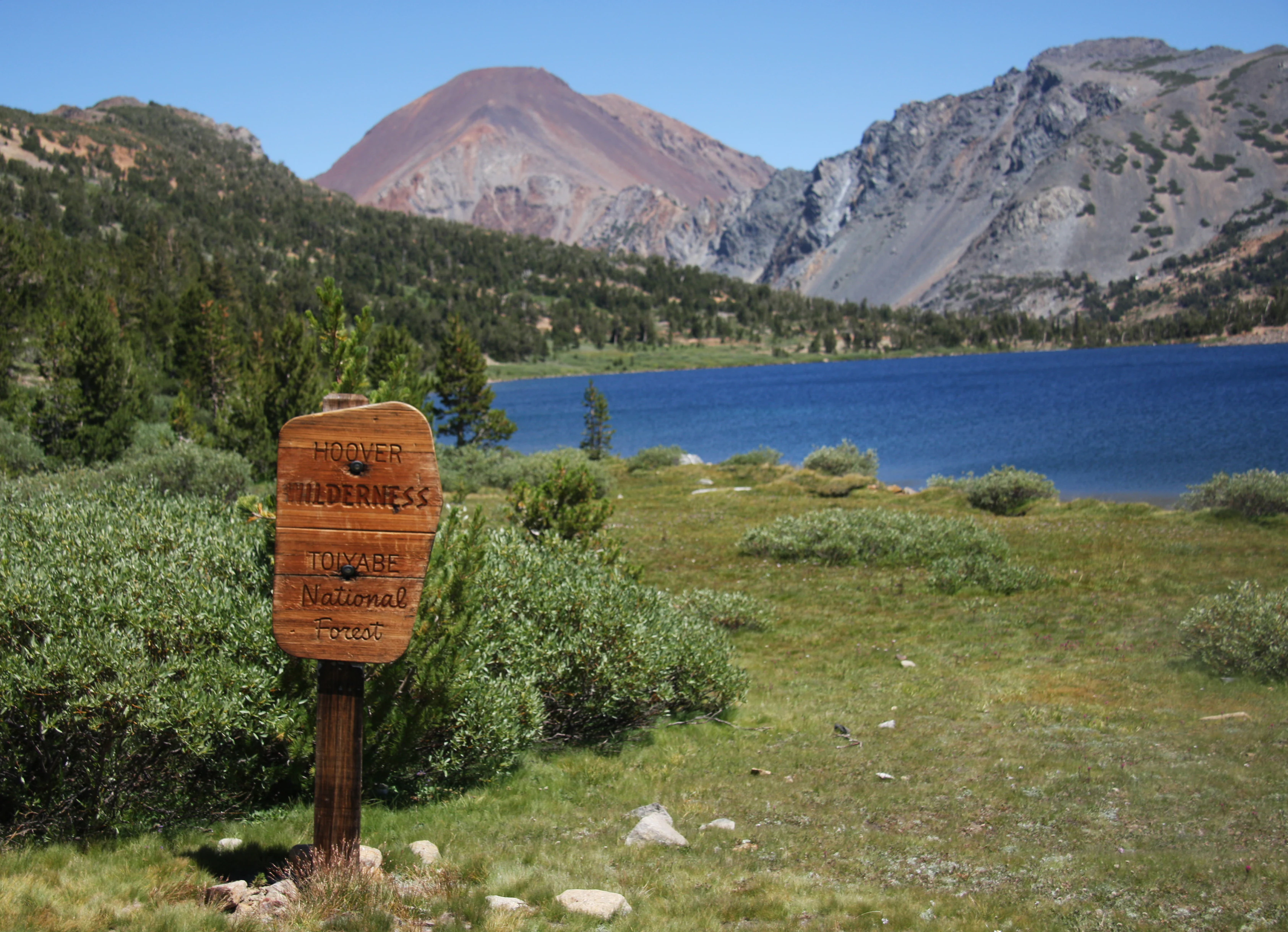
A wooden sign stands in a grassy field with a deep blue lake and rocky mountain peaks in the background.
A wooden sign marks the boundary of the Hoover Wilderness near Summit Lake.

Hoover Wilderness history and protected-area timeline

The Hoover Wilderness has a layered protection history beginning in 1931, when the U.S. Forest Service designated it as a Primitive Area. In 1956, it was reclassified as a Wild Area, reflecting evolving federal policy toward preserving undeveloped backcountry.

Its modern form dates to the passage of the 1964 Wilderness Act, through which the area became a formal Wilderness Area on January 1, 1964. The wilderness is named in honor of President Herbert Hoover. In 2009, the boundaries of the Hoover Wilderness were significantly expanded to reach its present-day extent.

The area also holds a place in environmental education history: it served as the setting for the National Geographic Society's 1976 children's book Camping Adventure, part of the "Books for Young Explorers" series, introducing young readers to the experience of a Sierra Nevada wilderness.

Hoover Wilderness landscape and geographic character

The Hoover Wilderness encompasses a classic eastern Sierra Nevada landscape, dominated by high terrain shaped by glaciers and uplift. Its terrain includes rugged alpine ridges, including the Sawtooth Ridge with the prominent Matterhorn Peak, as well as Dunderberg Peak in the southern portion of the wilderness.

Glacial action has produced a striking collection of basins and lake systems. Twenty Lakes Basin, above Saddlebag Lake, is a network of small alpine lakes and meadows ringed by rocky peaks. The Virginia Lakes Basin further north adds another compact cluster of lakes beneath the Sierra crest. Lundy Lake and Saddlebag Lake sit near the eastern approaches and serve as gateways to this higher country.

The wilderness occupies a long strip running approximately from near Sonora Pass in the north to Tioga Pass in the south, capturing the transition from forested canyon approaches to true alpine elevations. The combination of ridges, basins, and high-elevation lakes gives the landscape its varied visual rhythm.

Hoover Wilderness ecosystems, habitats, and plant life

The Hoover Wilderness preserves a clear ecological gradient from montane forest through subalpine and into alpine zones, reflecting the rapid elevation gain typical of the eastern Sierra Nevada. Lower elevations support coniferous forest cover, while higher slopes and basins transition into open meadows, talus, and bare rock.

The lake and basin systems within the wilderness constitute some of its most important habitat features. Twenty Lakes Basin and the Virginia Lakes Basin are notable for their dense clustering of small alpine lakes, wet meadows, and associated riparian zones, which support diverse alpine plant communities and provide habitat for wildlife adapted to high-elevation wet and rocky terrain.

The wilderness's headwater position is ecologically critical: the Walker River originates here and depends on the snowpack, meadows, and forested slopes of the basin for sustained seasonal flow. This watershed role underscores the ecological importance of the wilderness beyond its visible scenic value.

Hoover Wilderness wildlife and species highlights

The varied elevations and habitats of the Hoover Wilderness provide habitat typical of the eastern Sierra Nevada. Alpine basins, lakes, and meadows attract birdlife and small mammals adapted to high-elevation conditions, while forested lower slopes support additional wildlife communities tied to the conifer-dominated terrain.

The wilderness's importance as a Walker River headwater area also extends to aquatic ecosystems downstream, where the cold, snowmelt-driven flows shaped within the wilderness sustain fish and other aquatic life in the river system east of the Sierra.

Although detailed species inventories are limited, the combination of alpine, subalpine, and forested habitats, along with extensive undisturbed terrain, gives the wilderness strong wildlife value as part of the broader Sierra Nevada ecosystem.

Hoover Wilderness conservation status and protection priorities

The Hoover Wilderness stands as one of California's well-established examples of a federally designated Wilderness Area. Its protection under the 1964 Wilderness Act guarantees a high level of preservation, limiting roads, development, and mechanized access in favor of primitive recreation and ecological integrity.

The wilderness's conservation significance is enhanced by its watershed role: by protecting the headwaters of the Walker River, the area helps secure downstream water quality and flow regimes that are ecologically and economically important beyond the Sierra.

The 2009 boundary expansion increased the scale of preserved terrain, strengthening both the wilderness's ecological connectivity and the protected corridor along the eastern Sierra crest. As part of the Inyo and Humboldt-Toiyabe National Forests, the Hoover Wilderness contributes meaningfully to the network of protected landscapes that define the central Sierra Nevada.

Hoover Wilderness cultural meaning and human context

The Hoover Wilderness is named in honor of President Herbert Hoover, linking the area's identity to a figure closely associated with American conservation-era history. The name reflects an early federal practice of honoring national leaders through the naming of significant natural areas.

The area also entered broader American cultural life as the setting for National Geographic's 1976 children's book Camping Adventure, part of its "Books for Young Explorers" series, which used Sierra Nevada wilderness experiences to introduce young readers to outdoor adventure and conservation values.

Top sights and standout views in Hoover Wilderness

The Hoover Wilderness's strongest points of distinction lie in its concentration of alpine scenery along the eastern Sierra crest. Twenty Lakes Basin, the Virginia Lakes Basin, and the dramatic Sawtooth Ridge and Matterhorn Peak together define a stretch of landscape that captures the essence of eastern Sierra high country.

Equally distinctive is the wilderness's role as a Walker River headwater area, blending scenic alpine quality with tangible downstream ecological importance. Its multiple trailheads and long, narrow footprint make it a compact yet varied wilderness experience within easy reach of both Yosemite's doorstep and the eastern Sierra communities of Bridgeport and Sonora Pass.

Best time to visit Hoover Wilderness

As an alpine wilderness on the eastern side of the Sierra Nevada, the Hoover Wilderness follows a strongly seasonal character shaped by heavy Sierra snowfall. Most trails are buried under snow well into spring, and high basins such as Twenty Lakes Basin and Virginia Lakes are typically accessible only after the snowpack begins to melt.

The prime window for backcountry access generally runs from mid to late summer through early fall, when alpine lakes and meadows are at their most expressive, ridges and passes are snow-free, and the Walker River headwaters flow robustly. Visiting in this window offers the fullest landscape experience. Winter travel is possible but requires specialized preparation and is suited to experienced snow-season travelers.
Monthly climate preview

Month by month long term averages for representative mountain elevations in California

Hoover Wilderness Climate Normals, Annual Temperature and Precipitation Rhythm

Long term data from representative coordinates reveals substantial seasonal temperature shifts and monthly precipitation variations across the protected terrain. Accessing the complete twelve month profile provides granular baseline records for analyzing temperature ranges and precipitation patterns in depth.
Annual mean4 °C
-5 °C16 °C
Jan-5°
Feb-5°
Mar-3°
Apr
May
Jun11°
Jul16°
Aug15°
Sep11°
Oct
Nov
Dec-5°
Warmest month
July

15.8 °C

Coolest month
February

-5.1 °C

Wettest month
January

4.1 mm/day

Driest month
August

0.3 mm/day

Park location guide

Geography guide, regional context, and park location map for Hoover Wilderness

Hoover Wilderness park geography, regions, and map view in United States of America

Understand where Hoover Wilderness sits in United States of America through a broader geographic reading of the surrounding landscape, nearby location context, and its mapped position within the national park landscape.

How Hoover Wilderness fits into United States of America

The United States of America is a federal presidential republic and one of the world's largest countries by area and population. It consists of 50 states across a vast territory spanning multiple time zones, with its capital in Washington, D.C. and largest city in New York City. The nation has a diverse economy, influential political system, and significant cultural and military presence globally.

Wider geography shaping Hoover Wilderness in United States of America

The United States occupies a vast territory in North America, bordered by Canada to the north and Mexico to the south. The 48 contiguous states stretch from the Atlantic to the Pacific Ocean, while Alaska occupies the northwestern region and Hawaii is an archipelago in the Pacific. The country encompasses diverse terrain including the Rocky Mountains, Appalachian Mountains, Great Plains, and extensive river systems.

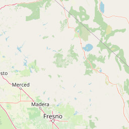
Map view of Hoover Wilderness

Use this park location map to pinpoint Hoover Wilderness in United States of America, understand its exact geographic position, and read its mapped placement within the surrounding landscape more clearly.

Pigeon | © OpenStreetMap contributors

Location context for Hoover Wilderness

CaliforniaMono County
Recorded earthquake history

View the Documented Earthquake History of the Hoover Wilderness

Consult the historical archive of seismic events recorded in the vicinity of the Hoover Wilderness. This curated catalogue uses USGS data to map recorded epicentres and magnitudes, helping to build a factual understanding of regional seismic activity across the eastern Sierra high country.

Hoover Wilderness Earthquake History

Catalogued events

1,953 events

Strongest magnitude

Magnitude 6.1

Most recent event

Dec 28, 2025

This history includes earthquakes recorded inside the park or within 50 km of its borders

Explore high-elevation terrain, glacial basins, and protected backcountry views across the Sierra crest.

Hoover Wilderness Photos and Alpine Scenery: Visualizing the Eastern Sierra Landscape

Examine high-resolution imagery showcasing the rugged alpine terrain, glacial basins, and rocky ridges of Hoover Wilderness. Visual documentation reveals the distinct topography and protected environmental character of the central Sierra Nevada backcountry.

A wooden sign stands in a grassy field with a deep blue lake and rocky mountain peaks in the background.

A mountain landscape showing a craggy peak rising above a green forest and a small body of water in the foreground.

Park atlas

Compare adjacent protected areas and regional alpine wilderness boundaries

Explore Parks Near Hoover Wilderness and Surrounding Sierra Nevada Landscapes

Browse nearby national parks and protected areas sharing the rugged terrain of the eastern Sierra crest. Discover connected high-mountain corridors to expand your regional geographic comparison beyond Hoover Wilderness.
Watercolor painting of a tranquil mountain lake surrounded by pine forests and distant rolling peaks in muted green and pink tones.
Wildlife reserveTuolumne County
Park boundaries overlap#1 closest

West

Emigrant Wilderness: A Detailed Geographic Atlas of Protected Sierra Nevada Landscapes

Mapping glaciated granite basins and volcanic ridges in Tuolumne County.

Emigrant Wilderness is a sprawling protected area defined by a distinct mix of granitic domes, cirques, and a unique volcanic sector in its northeastern reaches. Spanning from lower forest elevations to alpine peaks, the area provides a window into the complex geological history of the central Sierra Nevada. The terrain includes hundreds of high-country lakes and meadow systems that support diverse alpine ecosystems and represent the rugged nature of the Pacific Crest Trail corridor.

Area
454.37 km²
Established
1974
IUCN
Ib
Relief
Mountain
A watercolor painting showing soft green hills, distant pink-hued mountains, and a pale blue lake in a serene, stylized landscape.
Protected landscapeNevada
Park boundaries overlap#2 closest

Northeast

Humboldt, Toiyabe National Forest: Protected Landscape and Regional Mountain Geography

A vast network of Nevada mountain ranges and alpine wilderness

Humboldt, Toiyabe National Forest serves as a defining public land entity across Nevada and eastern California. As the largest national forest in the contiguous United States, it preserves a striking collection of isolated mountain ranges, including the Ruby Mountains and the rugged Jarbidge wilderness, within a broader basin-and-range landscape. Examine the boundaries and terrain that characterize this complex, high-desert ecosystem.

Area
25,454 km²
Established
1908
Relief
Mountain
Access
Easy access
A horizontal watercolor painting depicting a mountain range in the background with rolling hills and a winding river or stream in the foreground.
Protected landscapeCalifornia
Park boundaries overlap#3 closest

Southeast

Inyo National Forest: An Atlas of Protected Landscapes and Sierra Nevada Geography

High altitude wilderness and volcanic terrain in Eastern California

Spanning from the arid Owens Valley floor to the 14,000 foot crest of the Sierra Nevada, Inyo National Forest remains a cornerstone of the American West. This protected landscape contains the Ancient Bristlecone Pine Forest, Mount Whitney, and the Mono Inyo volcanic chain, providing a dense geographic record of glacial, tectonic, and ecological diversity across a vast managed corridor.

Area
7,702.71 km²
Established
1907
IUCN
Ib
Relief
Mountain
Watercolor painting of green rolling hills, a tree-lined foreground, and a soft pink sunset sky.
Protected landscapeCalifornia
Park boundaries overlap#4 closest

West

Stanislaus National Forest: Sierra Nevada Mountain Geography and Protected Wilderness Lands

California mountain terrain and forest landscape map

Stanislaus National Forest is a sprawling protected landscape located in the central Sierra Nevada of California. Characterized by volcanic and granite formations, the area protects critical watersheds, Wild and Scenic rivers, and large swaths of old growth forest that define the rugged mountain interior.

Area
3,634.48 km²
Established
1897
Relief
Mountain
Climate
Temperate
Watercolor painting showing mountains, a winding river, and green forests in the foreground and background
National parkCalifornia
Park boundaries overlap#5 closest

Southwest

Yosemite National Park: Protected Landscape Identity and Geographic Atlas Context

Mapped boundaries and regional setting for a key California national park.

Delve into the protected landscape identity of Yosemite National Park, examining its specific geographic features and its place within the broader atlas of California's natural areas. This entry provides detailed context on its mapped boundaries, regional positioning, and significance as a protected natural site, essential for understanding its landscape and conservation geography.

Area
3,070 km²
Established
1890
IUCN
II
Visitors
3.9M annual
A soft watercolor painting showing a range of gentle rolling hills and mountains in pale green, yellow, and violet tones against a white background.
Protected landscapeCalifornia
22 km away#6 closest

South

Sierra National Forest: Protected Landscapes of the Central California Sierra Nevada

Geography of alpine lakes, conifer forests, and mountain basins

Spanning from 900 to nearly 14,000 feet in elevation, Sierra National Forest protects a massive vertical range of California terrain. Discover its iconic wilderness areas and reservoir-studded landscape, providing a deep look at the geographic connectivity between major national parks in the central Sierra Nevada.

Area
5,300 km²
Established
1893
Relief
Mountain
Climate
Alpine
A watercolor painting showing a panoramic view of mountain ranges, a treeline, and a calm body of water in the foreground.
Wildlife reserveCalifornia
38 km away#7 closest

South

John Muir Wilderness: Sierra Nevada Protected Landscape and High Mountain Geography

California wilderness area with glacial basins and granite peaks

John Muir Wilderness represents one of the largest protected high-elevation areas in the contiguous United States. Spanning the Sierra Nevada crest, its granite terrain is sculpted by Pleistocene glaciation into sharp arêtes, deep canyons, and hundreds of alpine lakes. This wilderness serves as a vital geographic anchor for mountain ecosystems, offering an extensive look at the high-country landscape of eastern California.

Area
2,641.76 km²
Established
1964
IUCN
Ib
Relief
Mountain
Wildlife reserveFresno County
About 57 km away#8 closest

South

Kaiser Wilderness: Exploring the Alpine Ridges and Glacial Terrain of the Central Sierra Nevada

A federally protected wilderness area in Fresno County, California.

Kaiser Wilderness offers a dense collection of signature Sierra Nevada landforms, including granite cliffs, subalpine forests, and high-altitude lakes. This wildlife reserve preserves a rugged, glacier-scoured interior that provides a distinct contrast to the surrounding regional landscape of the Sierra National Forest, making it a critical entity for understanding mid-elevation mountain ecology.

Area
92 km²
Established
1976
IUCN
Ib
Relief
Mountain

Common questions about visiting, size, designation, and location context for Hoover Wilderness

Hoover Wilderness FAQs for park facts, access, geography, and protected area context

Find quick answers about Hoover Wilderness, including protected-area facts, park geography, trail and visitor context, and how the park fits into its surrounding country and regional landscape.
MoriAtlas Explorer

Continue Your Protected Areas Search Across the Global Atlas

Deepen your exploration by continuing the structured search for national parks and protected areas worldwide. Utilize the comprehensive filtering capabilities to compare different conservation landscapes and refine your understanding of global park geography. Discover more about the distribution and characteristics of protected natural areas.

Global natural geography