Mori Atlas logo
Wildlife reserveJedediah Smith Wilderness

Analyzing the glacially carved terrain and high-country connectivity within the Greater Yellowstone Ecosystem

Jedediah Smith Wilderness: A Comprehensive Geographic Atlas of Wyoming Protected Mountain Landscapes

The Jedediah Smith Wilderness encompasses 123,000 acres along the western slopes of the Teton Range in Wyoming. This protected wildlife reserve preserves a complex network of U-shaped valleys, high-altitude cirques, and subalpine forests that remain free from road access or mechanized development. As a vital segment of the Greater Yellowstone Ecosystem, the wilderness maintains significant ecological connectivity and offers a distinct western counterpoint to the more abrupt eastern Teton escarpments.

wilderness areaTeton Rangealpine terrainsubalpine forestsGreater Yellowstone Ecosystemglacial landscape

Jedediah Smith Wilderness

Wildlife reserve

Park overview

Structured park overview, official facts, and landscape profile for Jedediah Smith Wilderness

Jedediah Smith Wilderness park facts, protected area profile, and essential visitor context

Review the core facts for Jedediah Smith Wilderness, including designation, size, terrain, visitor scale, habitats, and operating context in one park-focused overview.

About Jedediah Smith Wilderness

The Jedediah Smith Wilderness occupies the rugged country on the western flank of the Teton Range in northwestern Wyoming. Created by Congress in 1984 and administered by the U.S. Forest Service as part of the Caribou-Targhee National Forest, the wilderness covers an extensive tract of high-elevation terrain that complements and extends the protections already found in neighboring Grand Teton National Park.

Topographically, the wilderness consists of the steep western slopes of the Tetons, carved by long-period glacial activity into cirques, U-shaped valleys, and tarns typical of the Range. Elevations rise from forested mid-slope valleys up through krummholz and alpine tundra near the crest of the Range. Several well-known basins and passes in the Teton backcountry, including Hurricane Pass and the surrounding Alaskan Basin area, sit within or adjacent to the wilderness, shaping its identity as a high-country hiking landscape.

Ecologically, the Jedediah Smith Wilderness lies within the Greater Yellowstone Ecosystem, one of the largest intact temperate ecosystems in the lower 48 states. This positioning gives the wilderness strong ecological continuity with adjacent national park and national forest lands, supporting wide-ranging species and processes that depend on large, connected blocks of wild habitat. Because the area is managed as congressionally designated wilderness, motorized and mechanized travel are prohibited, and the natural processes of the landscape, from avalanches and fires to wildlife movements, are allowed to continue with minimal human intervention.

For visitors, the wilderness primarily serves as a backpacking and horseback destination accessed by trailheads near the Teton Crest and the west side of the Range, with Grand Teton National Park essentially adjoining its eastern boundary. The wilderness's combination of dramatic mountain scenery, ecological linkage to Yellowstone, and strict federal protection makes it a defining component of the protected landscape complex of the northern Rockies.

Protection and recognition

Documented terrestrial protection scope and official recognition details

Jedediah Smith Wilderness Protection Status and Territorial Designation

Jedediah Smith Wilderness features a documented terrestrial protection scope that establishes its official conservation status. Verified protection data and international recognition records outline the environmental management framework governing this protected landscape.

Protection details

Protection scope
Terrestrial
Park context

Deeper park guide and search-rich context for Jedediah Smith Wilderness

Jedediah Smith Wilderness history, landscape, wildlife, and travel context

Explore Jedediah Smith Wilderness through its history, landscape character, ecosystems, wildlife, conservation priorities, cultural context, and seasonal travel timing in a structured park guide built for atlas discovery and search intent.

Why Jedediah Smith Wilderness stands out

The Jedediah Smith Wilderness is best known as the federally protected backcountry that buffers the western face of the Teton Range, preserving glacially carved alpine basins, subalpine fir and spruce forests, and a corridor of high-country wildlife habitat within the Greater Yellowstone Ecosystem. Its proximity to Grand Teton National Park, combined with its strict wilderness designation under the 1964 Wilderness Act, gives it a reputation as a remote, trail-only landscape connecting two of America's most iconic mountain protected areas.
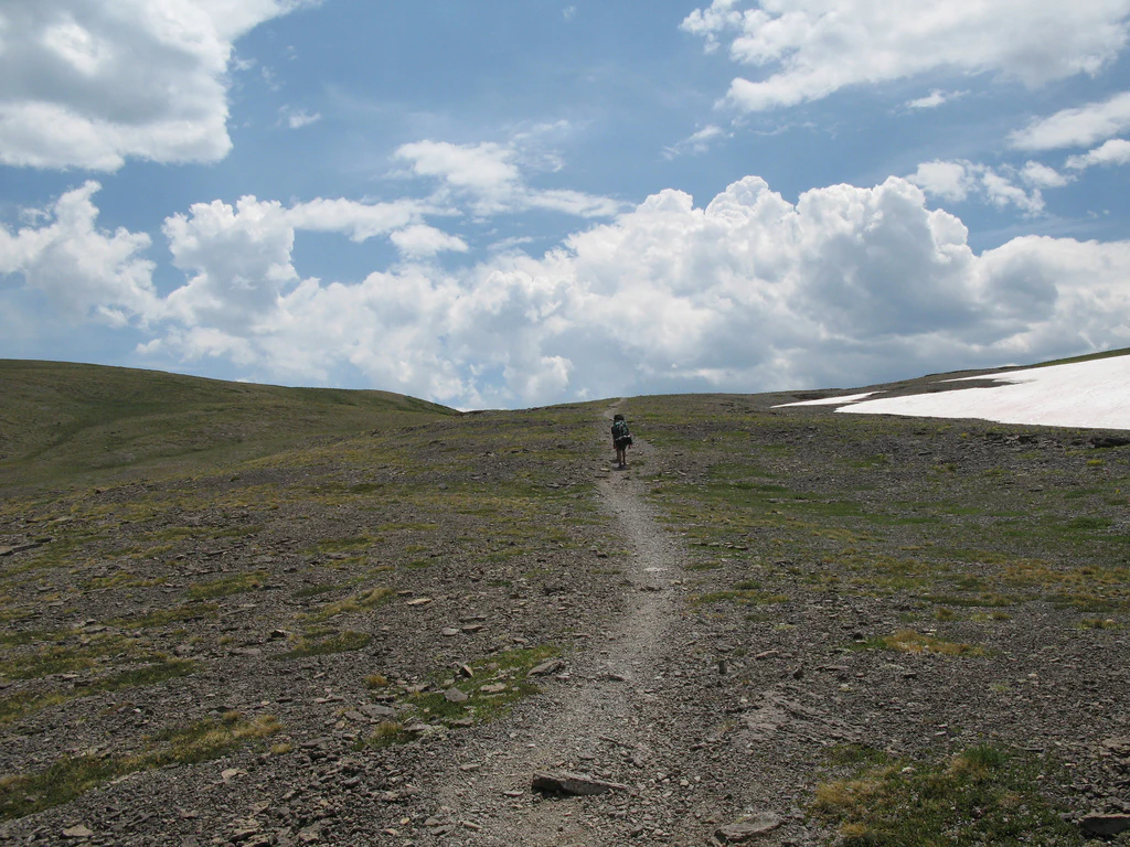
A lone hiker walks along a narrow, rocky dirt trail winding through a barren, high-alpine landscape under a bright, cloudy sky with a patch of snow visible on the right.
A hiker traverses the high elevation Hurricane Pass trail in the Jedediah Smith Wilderness.

Jedediah Smith Wilderness history and protected-area timeline

The Jedediah Smith Wilderness was formally designated by the United States Congress in 1984 as part of the broader expansion of the National Wilderness Preservation System that occurred in the mid-1980s. The designation placed the area under the authority of the 1964 Wilderness Act, which requires that wilderness areas retain their primeval character and are protected from roads, motorized use, logging, mining, and permanent structures.

Management responsibility for the wilderness falls to the U.S. Forest Service, because the lands lie within the Caribou-Targhee National Forest. The wilderness shares its boundary with Grand Teton National Park, an arrangement that effectively connects federally protected Teton terrain across jurisdictional lines. The wilderness takes its name from Jedediah Smith, a 19th-century American frontiersman and explorer whose fur-trapping and mapping work took him through the Rocky Mountain West.

Although the formal wilderness designation is comparatively recent, the landscape itself has a long history of human use, from Indigenous travel and hunting routes across the Teton Range to later fur-trapping, ranching, and recreational mountaineering. Designation as wilderness in 1984 marked a shift toward permanent legal protection of the area's ecological and scenic values, cementing its role within the larger network of protected lands that includes Grand Teton and the Greater Yellowstone Ecosystem.

Jedediah Smith Wilderness landscape and geographic character

The Jedediah Smith Wilderness encompasses the steep, glacially sculpted western face of the Teton Range. The underlying geology belongs to the same mountain-building story that formed the dramatic eastern wall of the Tetons, but here the slopes fall more gently toward the Snake River plain in a series of broad ridges, basins, and timbered valleys rather than a single abrupt escarpment.

Long-period glacial erosion has shaped much of the visible landforms. Classic U-shaped valleys, hanging tributaries, alpine cirques, and high tarns define the upper elevations. Forests of subalpine fir, Engelmann spruce, lodgepole pine, and aspen clothe the mid-slopes, giving way to open meadows, krummholz, and bare alpine rock toward the crest. Prominent topographic features in or near the wilderness include Hurricane Pass and the surrounding Alaskan Basin, which sit astride the high traverse between the western and eastern approaches to the Teton high country.

Drainage on the wilderness side feeds westward into streams that ultimately join the Snake River system, in contrast to the eastward-flowing streams that drain into the Snake River below the Teton fault scarp on the park side. This contrast between the abrupt eastern face of the Range and the longer, more gradual western slope is one of the defining visual characteristics of the wilderness and influences everything from vegetation patterns to trail corridors within it.

Jedediah Smith Wilderness ecosystems, habitats, and plant life

Ecologically, the Jedediah Smith Wilderness represents a near-complete elevational gradient of vegetation communities typical of the northern Rockies, compressed onto the western slope of the Teton Range. Lower elevations support stands of coniferous forest dominated by lodgepole pine and mixed conifers, with aspen occupying the moister draws and disturbance sites.

Higher up the slope, forests transition into subalpine communities of Engelmann spruce and subalpine fir, often interspersed with avalanche chutes, willow thickets, and grassy park-like openings. Above treeline, the landscape opens into alpine tundra with low-growing cushion plants, sedge meadows, rock fields, and persistent snowbeds. Wetlands and beaver-influenced streams occur in the broader valley bottoms, adding aquatic and riparian habitats to the terrestrial mosaic.

Because the wilderness lies within the Greater Yellowstone Ecosystem, it functions not as an isolated preserve but as a key piece of a much larger ecological network. Ecological processes such as predator-prey interactions, fire dynamics, and seasonal migrations operate across property lines, and the wilderness contributes elevation, habitat diversity, and a buffer against human disturbance for the broader ecosystem.

Jedediah Smith Wilderness wildlife and species highlights

The combination of intact forest cover, alpine terrain, and connection to adjacent protected lands makes the Jedediah Smith Wilderness significant habitat for many of the species most associated with the Greater Yellowstone Ecosystem. Large mammals characteristic of the area include elk, mule deer, moose, and bighorn sheep in the higher rocky zones, along with predators such as grizzly bears and black bears that benefit from the wilderness's strict restrictions on human activity.

Wolves, mountain lions, and coyotes also range through the wilderness, taking advantage of the contiguity with Grand Teton and the larger Yellowstone landscape. Smaller mammals, including pine martens, marmots, pikas, and red squirrels, are common in the forested and alpine zones. Beaver activity in the valley bottoms contributes to the wetland character of the lower elevations.

Birdlife in the wilderness reflects the range of habitats from low-elevation conifer forest to alpine tundra. Raptors such as golden eagles, bald eagles, and various hawks hunt the open terrain, while species like Clark's nutcracker, gray jay, and rosy-finches are associated with the higher subalpine and alpine zones. The area's protected status and large size help maintain habitat conditions for both resident species and migrants that move through the Greater Yellowstone ecosystem.

Jedediah Smith Wilderness conservation status and protection priorities

The primary conservation value of the Jedediah Smith Wilderness lies in its wilderness designation itself, established by Congress in 1984 and governed by the 1964 Wilderness Act. This designation prohibits roads, motorized and mechanized travel, logging, mining, and permanent structures, preserving a landscape where natural ecological and physical processes can operate largely unimpeded. As part of the Caribou-Targhee National Forest, the wilderness is managed by the U.S. Forest Service in coordination with broader national forest conservation objectives.

The wilderness is a significant component of the Greater Yellowstone Ecosystem, one of the largest and best-studied intact temperate ecosystems in the contiguous United States. By occupying the western slopes of the Teton Range, it extends the contiguous block of protected habitat that includes Grand Teton National Park and contributes to the connectivity needed by wide-ranging species such as grizzly bears, wolves, and elk.

Conservation concerns in the area mirror those of the broader Yellowstone region, including the management of wildlife migrations across jurisdictional boundaries, the relationship between wilderness character and recreation pressure, and the long-term effects of changing climate on alpine habitats and snowpack. The wilderness designation gives managers a strong legal framework for addressing these issues within its boundaries, while its ecological position inside the larger ecosystem amplifies its conservation significance well beyond its own footprint.

Top sights and standout views in Jedediah Smith Wilderness

The Jedediah Smith Wilderness's defining highlights are its position on the western side of the Teton Range, its strict congressionally designated wilderness status, and its role as a key western anchor of the Greater Yellowstone Ecosystem. Notable features include the Hurricane Pass and Alaskan Basin corridor, glaciated cirques and U-shaped valleys, and large continuous tracts of subalpine forest and alpine tundra that remain free of roads and mechanized access.

The wilderness also stands out for its direct adjacency to Grand Teton National Park, which means the protected landscape of the Teton Range effectively continues across administrative boundaries. This juxtaposition, along with the wilderness's namesake connection to the early American explorer Jedediah Smith, gives the area both ecological and historical significance within the broader Rocky Mountain West.

Best time to visit Jedediah Smith Wilderness

Summer is the primary season for visiting the Jedediah Smith Wilderness, when snow has melted from most trails and high passes become accessible to hikers and horseback riders. Mid to late summer generally offers the most reliable conditions for reaching alpine terrain such as Hurricane Pass and the basins above, with wildflower displays in meadow and tundra zones and long daylight hours for backcountry travel.

Late spring and early autumn can also be attractive but bring trade-offs. Spring commonly features lingering snow at elevation, swollen streams, and muddy lower-elevation trails, while early fall can provide cooler temperatures, fewer insects, and the first hints of aspens turning color, though high-country weather becomes less predictable. Winter conditions are severe, with deep snow and limited trail access, and visits at that time of year generally require specialized equipment and experience. As with any designated wilderness, weather in the high country can shift quickly regardless of season.

Monthly climate preview

Long-term representative temperature and precipitation patterns across the elevation profile

Jedediah Smith Wilderness Climate Normals and Annual Weather by Month

Jedediah Smith Wilderness records tracked annual temperature and precipitation cycles from representative elevation coordinates spanning twelve distinct monthly periods. Examining the complete monthly climate normals reveals detailed temperature variations and precipitation distributions across the protected landscape.
Annual mean0 °C
-12 °C15 °C
Jan-12°
Feb-11°
Mar-7°
Apr-2°
May
Jun
Jul15°
Aug14°
Sep
Oct
Nov-7°
Dec-12°
Warmest month
July

14.7 °C

Coolest month
December

-12 °C

Wettest month
December

2.9 mm/day

Driest month
July

1.1 mm/day

Park location guide

Geography guide, regional context, and park location map for Jedediah Smith Wilderness

Jedediah Smith Wilderness park geography, regions, and map view in United States of America

Understand where Jedediah Smith Wilderness sits in United States of America through a broader geographic reading of the surrounding landscape, nearby location context, and its mapped position within the national park landscape.

How Jedediah Smith Wilderness fits into United States of America

The United States of America is a federal presidential republic and one of the world's largest countries by area and population. It consists of 50 states across a vast territory spanning multiple time zones, with its capital in Washington, D.C. and largest city in New York City. The nation has a diverse economy, influential political system, and significant cultural and military presence globally.

Wider geography shaping Jedediah Smith Wilderness in United States of America

The United States occupies a vast territory in North America, bordered by Canada to the north and Mexico to the south. The 48 contiguous states stretch from the Atlantic to the Pacific Ocean, while Alaska occupies the northwestern region and Hawaii is an archipelago in the Pacific. The country encompasses diverse terrain including the Rocky Mountains, Appalachian Mountains, Great Plains, and extensive river systems.

Map view of Jedediah Smith Wilderness

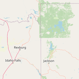
Use this park location map to pinpoint Jedediah Smith Wilderness in United States of America, understand its exact geographic position, and read its mapped placement within the surrounding landscape more clearly.

Pigeon | © OpenStreetMap contributors

Location context for Jedediah Smith Wilderness

Wyoming
Recorded earthquake history

View the Jedediah Smith Wilderness Earthquake History and Seismic Catalogue

Review documented seismic events associated with the Jedediah Smith Wilderness through this structured historical catalogue. MoriAtlas provides access to recorded earthquake dates and magnitudes for this significant Teton Range wilderness area to support regional geographic research.

Jedediah Smith Wilderness Earthquake History

Catalogued events

222 events

Strongest magnitude

Magnitude 5

Most recent event

Sep 7, 2026

This history includes earthquakes recorded inside the park or within 50 km of its borders

Visual reference of alpine terrain, glacial basins, and subalpine forests

Jedediah Smith Wilderness Photos and Scenery: Exploring Teton Landscapes

Browse detailed imagery showcasing the rugged glacial valleys and high-country terrain of Jedediah Smith Wilderness. Visual records reveal the distinct protected-area character and wild habitats spanning the western Teton Range.

A lone hiker walks along a narrow, rocky dirt trail winding through a barren, high-alpine landscape under a bright, cloudy sky with a patch of snow visible on the right.

Park atlas

Compare regional mountain terrain and connected conservation lands across the Teton Range.

Explore Other Parks Near Jedediah Smith Wilderness and Surrounding Protected Areas

Browse nearby national parks and protected areas sharing the rugged alpine terrain of the Teton Range. Comparing adjacent wilderness corridors reveals the broader ecological scale of the Greater Yellowstone Ecosystem.
National parkUnited States of America
Park boundaries overlap#1 closest

Southeast

Grand Teton National Park: Protected Landscape and Geographic Atlas Exploration

Explore the mapped terrain and regional park geography.

Grand Teton National Park is a protected landscape offering rich geographic discovery opportunities within the United States of America. This detailed entry facilitates an atlas-style exploration of its mapped boundaries, the surrounding regional geography, and its identity as a significant national park. Understand the specific landscape context and discover its placement within the broader natural terrain of North America.

Area
1,300 km²
Established
1929
IUCN
II
Visitors
2.8M annual
National parkWyoming
1.8 km away#2 closest

Northeast

Yellowstone National Park: US National Park Protected Landscape & Geographic Atlas

Explore mapped boundaries and regional natural landscape context.

Yellowstone National Park represents a significant protected landscape within Wyoming, designated as a US national park. This entry offers detailed insight into its geographic scope, mapped boundaries, and the unique natural terrain that defines it. Understand its role in regional geography and discover its protected-area identity through a structured atlas exploration, providing context for its conservation landscape.

Area
8,983.18 km²
Established
1872
IUCN
II
Visitors
4.7M annual
Watercolor painting of a peaceful mountain valley landscape, showing a small winding stream in the foreground, grassy meadows, clusters of pine trees, and rolling mountain peaks in a soft, sunset-colored sky.
Protected landscapeWyoming
60 km away#3 closest

Northeast

Shoshone National Forest: A Comprehensive Map and Geography of America's Oldest National Forest

Rugged wilderness and glacial peaks in Wyoming

Discover the immense geographic scale of Shoshone National Forest, which protects a diverse landscape ranging from sagebrush valleys to 13,000-foot granite summits. This atlas overview details its role within the Greater Yellowstone Ecosystem and its expansive, federally designated wilderness areas, offering a clear perspective on its volcanic and glacial terrain.

Area
9,992.69 km²
Established
1891
IUCN
VI
Visitors
500K annual
Nature reserveBeaverhead County
79 km away#4 closest

Northwest

Red Rock Lakes Wilderness: Nature Reserve and Wetland Geography in Beaverhead County

High elevation marshes and protected water basins.

Red Rock Lakes Wilderness preserves an extensive high-elevation wetland complex in Beaverhead County, Montana. This nature reserve, characterized by shallow lake basins and forested mountain ridges, serves as a vital ecological corridor in the Northern Rockies. Its protected landscape offers a study in water-driven geography, where remote marshes and reflective lakes define the terrain's character.

Area
130.9 km²
Established
1976
IUCN
Ib
Relief
Upland
Wildlife reserveMontana
87 km away#5 closest

North

Lee Metcalf Wilderness: Geographic Profile and Protected Landscape Boundaries in Montana

Mapping rugged alpine terrain across four distinct mountainous units

Located in southwestern Montana, the Lee Metcalf Wilderness serves as a cornerstone of ecological connectivity within the Greater Yellowstone Ecosystem. Spanning over 250,000 acres, this protected area features a unique fragmented geography consisting of the Bear Trap Canyon, Spanish Peaks, Taylor-Hilgard, and Monument Mountains units. The landscape is defined by its roadless mountain ridges, forested slopes, and deep river corridors, providing essential sanctuary for large mammal populations.

Area
1,029.07 km²
Established
1983
IUCN
Ib
Relief
Mountain
A soft, minimalist watercolor painting of a serene lake nestled among rolling hills under a gentle, pastel-toned sky.
Protected landscapeWyoming
89 km away#6 closest

Southeast

Fitzpatrick Wilderness: Exploring the Rugged Protected Landscapes of Western Wyoming

A core alpine environment within the Wind River Range.

Fitzpatrick Wilderness represents one of the most uncompromisingly wild segments of the Wind River Range, featuring persistent glaciers, dramatic U-shaped valleys, and high granite spires. This protected landscape offers a deep look into the alpine geography of Wyoming, preserved under the Wilderness Act to maintain its rugged character, remote glacial cirques, and intricate mountain ecosystems.

Area
803.4 km²
Established
1976
IUCN
Ib
Relief
Mountain
A pale, wide watercolor landscape illustration depicting mountain peaks above a line of evergreen trees and a flat foreground.
Protected areaWyoming
150 km away#7 closest

Southeast

Popo Agie Wilderness: Protected Landscapes in the Wyoming Wind River Range

High-altitude alpine terrain and glacial basins

The Popo Agie Wilderness in Wyoming encompasses a dramatic vertical landscape, ranging from forested valleys to alpine summits above 13,000 feet. This protected area features the iconic Cirque of the Towers, dense hydrological networks of glacial tarns, and expansive granite formations that anchor its identity within the Greater Yellowstone Ecosystem.

Area
412.3 km²
Established
1984
IUCN
Ib
Relief
Mountain
Soft watercolor illustration of a rolling mountain landscape with a forested foreground and faded, distant peaks.
Protected landscapeIdaho
154 km away#8 closest

Northwest

Salmon, Challis National Forest: Geography and Protected Land Map in Central Idaho

Extensive alpine ridges and wild river corridors

Spanning over 4.2 million acres, Salmon, Challis National Forest is a foundational protected landscape in Idaho. This area includes the highest peaks in the state, such as Borah Peak, and holds the majority of the Frank Church, River of No Return Wilderness. Utilize this atlas resource to examine the intricate mountain topography, expansive river systems, and the contiguous wild corridors that define this significant portion of the northern Rockies.

Area
17,142.2 km²
Established
1908
Relief
Mountain
Climate
Temperate

Common questions about visiting, size, designation, and location context for Jedediah Smith Wilderness

Jedediah Smith Wilderness FAQs for park facts, access, geography, and protected area context

Find quick answers about Jedediah Smith Wilderness, including protected-area facts, park geography, trail and visitor context, and how the park fits into its surrounding country and regional landscape.
MoriAtlas Explorer

Continue Your Protected Areas Search Across the Global Atlas

Deepen your exploration by continuing the structured search for national parks and protected areas worldwide. Utilize the comprehensive filtering capabilities to compare different conservation landscapes and refine your understanding of global park geography. Discover more about the distribution and characteristics of protected natural areas.

Global natural geography