Mori Atlas logo
Protected landscapeJemez National Recreation Area

Tracing the geological boundaries and canyon systems within the Santa Fe National Forest

Jemez National Recreation Area: A Protected Landscape in Northern New Mexico's Volcanic Mountains

Jemez National Recreation Area spans 57,650 acres of forested plateaus and deeply incised river canyons within the volcanic heart of Sandoval County. This managed protected landscape highlights a distinct transition between high-elevation coniferous forests and the dramatic river corridors characteristic of the American Southwest. Exploring these boundaries reveals a complex mosaic of public lands and cultural sites that share deep geological connections with the nearby Valles Caldera National Preserve.

national recreation areavolcanic landscapecanyon sceneryconifer forestriver canyonhot springs country

Jemez National Recreation Area

Protected landscape

Park overview

Structured park overview, official facts, and landscape profile for Jemez National Recreation Area

Jemez National Recreation Area park facts, protected area profile, and essential visitor context

Review the core facts for Jemez National Recreation Area, including designation, size, terrain, visitor scale, habitats, and operating context in one park-focused overview.

About Jemez National Recreation Area

Jemez National Recreation Area is one of the comparatively small set of congressionally designated national recreation areas in the United States, and the only one located in New Mexico. It consists of lands within the Santa Fe National Forest, administered by the U.S. Forest Service through the Jemez Ranger District. Rather than being a strict wilderness preservation unit, the area is intentionally managed to balance active outdoor recreation with landscape conservation. Fishing, camping, rock climbing, hiking, and hunting are all promoted as legitimate uses of the land, while mining activities are restricted to pre-existing claims, reflecting a clear intent to safeguard the area's recreational and scenic character.

Geographically, the recreation area sits in the southern part of the Jemez Mountains, a region shaped by ancient volcanic activity that produced the broader Valles Caldera landscape to its north. Within its boundaries, visitors encounter deeply carved river canyons along the Jemez River system, mixed conifer forests on plateau-like uplands, and a transition zone that links the higher volcanic terrain of the preserve with the warmer canyon environments dropping toward the Rio Grande watershed. The area's character reflects this geological inheritance: a region where volcanic ridges, forested mesas, and river-cut gorges combine into a varied recreational landscape.

The recreation area is also defined by its human and cultural context. Roughly 9,350 acres within its boundary are private lands, creating a checkerboard of ownership that influences management. The U.S. Forest Service is required to consult with Jemez Pueblo on matters related to cultural and religious sites in the area and may temporarily close lands to support traditional uses. This makes the recreation area not simply a place for outdoor activity but also a working landscape where national forest management intersects with the cultural heritage of one of New Mexico's historic Pueblo communities.

Its adjacency to the Valles Caldera National Preserve further strengthens its ecological and scenic profile. Together, these two units help protect a large, contiguous block of the Jemez Mountains, expanding opportunities for hiking, wildlife observation, and scenic driving across one of the Southwest's most distinctive volcanic regions.

Quick facts and research context for Jemez National Recreation Area

Jemez National Recreation Area covers about 57,650 acres in Sandoval County, New Mexico, within the Santa Fe National Forest. It is governed by the United States Forest Service and administered through the Jemez Ranger District. The area was established on October 12, 1993, by Public Law 103-104, and is used for fishing, camping, rock climbing, hunting, and hiking. Approximately 9,350 acres are private land, and the area borders the Valles Caldera National Preserve, reinforcing its position within a major volcanic landscape of northern New Mexico.

Protection and recognition

Terrestrial conservation framework and verified administrative status records

Jemez National Recreation Area Protection Status and Formal Recognition Data

Jemez National Recreation Area holds documented terrestrial protection status within official conservation frameworks. Official records compile structural management scope, designation parameters, and international recognition details where available.

Protection details

Protection scope
Terrestrial
Transboundary protection
No
Park context

Deeper park guide and search-rich context for Jemez National Recreation Area

Jemez National Recreation Area history, landscape, wildlife, and travel context

Explore Jemez National Recreation Area through its history, landscape character, ecosystems, wildlife, conservation priorities, cultural context, and seasonal travel timing in a structured park guide built for atlas discovery and search intent.

Why Jemez National Recreation Area stands out

Jemez National Recreation Area is best known for its position in the Jemez Mountains of northern New Mexico, where deep river canyons, forested uplands, and the volcanic terrain of the broader Valles Caldera region come together. The area stands out as a Forest Service recreation landscape where vigorous outdoor recreation coexists with cultural consultation requirements tied to nearby Jemez Pueblo. Its combination of canyon scenery, hot springs heritage around Jemez Springs, and proximity to the Valles Caldera National Preserve gives the area a distinctive identity within the Santa Fe National Forest.

Jemez National Recreation Area history and protected-area timeline

Jemez National Recreation Area was established on October 12, 1993, through Public Law 103-104, creating a congressionally designated recreation landscape within the existing Santa Fe National Forest. The designation reflected a recognition of the Jemez Mountains as a region of significant recreational value, where forest-based outdoor activities had long drawn visitors from across New Mexico and beyond.

From the outset, the recreation area was designed to function differently from a wilderness or strict preservation reserve. The U.S. Forest Service was directed to promote the area for fishing, camping, rock climbing, hunting, and hiking, while also limiting new mining activity to pre-existing claims. This combination of active recreation and resource protection gave the area a hybrid management identity that continues to shape how it is administered through the Jemez Ranger District.

The establishment of the recreation area also formalized a relationship with the nearby Valles Caldera National Preserve, which borders the area on its northern edge. Together, these designations have helped frame the Jemez Mountains as a landscape of national significance, recognized for both its volcanic geology and its capacity to support a wide range of traditional outdoor pursuits.

Jemez National Recreation Area landscape and geographic character

The landscape of Jemez National Recreation Area reflects the dramatic geological history of the Jemez Mountains in northern New Mexico. The terrain is shaped by ancient volcanism that produced the broader Valles Caldera region to the north, leaving behind a mosaic of volcanic ridges, forested plateaus, and deeply incised river canyons. Within the recreation area, the Jemez River and its tributaries have carved through this volcanic substrate, creating canyon scenery that contrasts sharply with the forested uplands above.

Visitors moving through the area encounter a range of elevations and landforms, from warmer canyon bottoms with riparian vegetation to higher forest zones supporting mixed conifers typical of the southern Rockies. The effect is a layered landscape in which steep canyon walls, broad forested benches, and volcanic domes combine into a varied scenic setting. Around the community of Jemez Springs, the area's hot springs and rivers add another visual element, contributing to the perception of the region as a transition between canyon country and high volcanic plateau.

The proximity of the recreation area to the Valles Caldera National Preserve reinforces the perception of the landscape as part of a larger volcanic system. Travellers approaching from the south can move from the forest and canyon environments of the recreation area into the broad caldera terrain of the preserve within a short distance, experiencing two closely linked expressions of the same underlying geology.

Jemez National Recreation Area ecosystems, habitats, and plant life

The ecological character of the Jemez National Recreation Area is closely tied to its position within the Jemez Mountains and the broader Santa Fe National Forest. Its forests combine conifer species typical of the southern Rocky Mountains with woodland and shrub communities adapted to the volcanic soils of the region. The canyon environments along the Jemez River system add a sharply different habitat layer, supporting riparian vegetation, cooler microclimates, and transitional zones between forest and canyon ecosystems.

This combination of habitats gives the recreation area a diverse ecological profile for its size. Mixed conifer forests on the higher benches, pinyon-juniper elements on drier slopes, and riparian corridors along the river all contribute to a landscape capable of supporting varied wildlife communities. The ecological value of the recreation area is amplified by its adjacency to the Valles Caldera National Preserve, which extends the area's habitat continuity into a much larger block of protected volcanic terrain.

The result is a recreation area that, although not designated primarily for ecological preservation, plays a meaningful role in maintaining forest and canyon habitat within the Jemez Mountains. Its location within the Santa Fe National Forest further embeds the area in a matrix of federally managed land, supporting broader ecological connectivity across the region.

Jemez National Recreation Area wildlife and species highlights

Wildlife in Jemez National Recreation Area reflects the diverse habitats produced by the area's mix of forested uplands and river-cut canyons. The forests of the Jemez Mountains support populations of deer and other ungulates typical of New Mexico's national forests, while the canyon and riparian environments provide habitat structure for a range of birdlife and smaller mammals. Hunting is explicitly promoted as a legitimate use of the area, reflecting the presence of game species across its landscape.

The river corridors of the Jemez River and its tributaries support both aquatic life and riparian-dependent species, contributing to the area's ecological richness. The mosaic of habitats created by elevation changes, canyon topography, and volcanic geology gives the recreation area a varied capacity to host wildlife across relatively short distances. Its adjacency to the Valles Caldera National Preserve further extends these habitat patterns, allowing wildlife movement across a larger connected landscape.

While the area is not managed primarily as a wildlife sanctuary, its combination of protected forest, canyon habitat, and connection to adjacent preserves gives it a meaningful place in the broader wildlife context of northern New Mexico.

Jemez National Recreation Area conservation status and protection priorities

Jemez National Recreation Area contributes to conservation in northern New Mexico by protecting a substantial block of the Jemez Mountains within the Santa Fe National Forest. Its 57,650 acres preserve a landscape of volcanic ridges, forested plateaus, and canyon ecosystems that would otherwise be subject to more fragmented management. The restriction of new mining to pre-existing claims reflects an intent to maintain the area's scenic and recreational values over the long term.

The recreation area's conservation significance is also linked to its relationship with the Valles Caldera National Preserve. Together, these two units help protect a large, connected portion of one of the most distinctive volcanic landscapes in the southwestern United States. This connectivity amplifies the ecological value of the recreation area beyond its own boundaries, supporting wildlife movement and habitat continuity across the Jemez Mountains.

The consultation requirement between the U.S. Forest Service and Jemez Pueblo adds a cultural dimension to conservation in the area. By recognizing traditional cultural and religious sites and allowing temporary closures for traditional uses, the area's management framework integrates cultural heritage protection into its broader conservation approach, making it a landscape where ecological and cultural values are both actively considered.

Jemez National Recreation Area cultural meaning and human context

The cultural context of Jemez National Recreation Area is closely tied to the long history of the Jemez region in northern New Mexico. The area falls within a landscape that has been part of the traditional homeland of Jemez Pueblo, one of the surviving Pueblo communities of New Mexico. Federal management of the area formally recognizes this relationship by requiring consultation with the pueblo on matters affecting cultural and religious sites, and by allowing closures to accommodate traditional uses.

Beyond its Pueblo heritage, the area also reflects a long tradition of outdoor recreation in the Jemez Mountains, including historic use of the hot springs near Jemez Springs. The community of Jemez Springs itself has long been associated with these cultural and recreational traditions, providing a regional hub for visitors exploring the canyons, forests, and thermal features of the surrounding mountains. Together, these threads connect the recreation area to a deeper story of human presence and use of the Jemez landscape.

Top sights and standout views in Jemez National Recreation Area

Jemez National Recreation Area stands out for its combination of volcanic canyon scenery, forested uplands, and connection to the Valles Caldera system. Its designation within the Santa Fe National Forest links it to one of New Mexico's most significant national forest landscapes, while its formal consultation relationship with Jemez Pueblo distinguishes it from many purely recreational public lands.

Visitors and researchers value the area as a place where recreational opportunities, ecological diversity, and cultural heritage meet within a single management unit. The area's role as a neighbor to the Valles Caldera National Preserve, its emphasis on a broad range of outdoor activities, and its recognition of Pueblo cultural ties together give it a distinctive profile among national recreation areas in the United States.

Best time to visit Jemez National Recreation Area

The Jemez Mountains experience the strong seasonal contrasts typical of northern New Mexico, with snow at higher elevations in winter and warm temperatures in the canyon areas during summer. Visiting in late spring through early autumn generally offers the most accessible conditions for hiking, camping, and exploring the canyon and river environments of the recreation area. Summer brings warmth to the lower elevations but also afternoon thunderstorms typical of the region's mountain climate.

Fall is often considered one of the most scenic seasons, when cooler temperatures and changing light enhance the visibility of canyon walls and forest landscapes. Winter conditions can limit access to higher forests and some roads, but may also emphasize the area's quieter character. Hunters visiting in autumn seasons may find the area especially active, reflecting its long tradition of hunting as a permitted use.
Monthly climate preview

Long-term temperature ranges and precipitation patterns across Sandoval County

Jemez National Recreation Area Climate Normals and Monthly Weather Records

Jemez National Recreation Area records distinct long term temperature shifts and monthly precipitation variations across its representative coordinate point. Reviewing the complete twelve month climate normals provides deeper numerical context for temperature bounds and precipitation averages.
Annual mean9 °C
-3 °C21 °C
Jan-3°
Feb-1°
Mar
Apr
May13°
Jun19°
Jul21°
Aug20°
Sep16°
Oct
Nov
Dec-3°
Warmest month
July

21.2 °C

Coolest month
January

-2.9 °C

Wettest month
July

1.7 mm/day

Driest month
June

0.6 mm/day

Park location guide

Geography guide, regional context, and park location map for Jemez National Recreation Area

Jemez National Recreation Area park geography, regions, and map view in United States of America

Understand where Jemez National Recreation Area sits in United States of America through a broader geographic reading of the surrounding landscape, nearby location context, and its mapped position within the national park landscape.

How Jemez National Recreation Area fits into United States of America

The United States of America is a federal presidential republic and one of the world's largest countries by area and population. It consists of 50 states across a vast territory spanning multiple time zones, with its capital in Washington, D.C. and largest city in New York City. The nation has a diverse economy, influential political system, and significant cultural and military presence globally.

Wider geography shaping Jemez National Recreation Area in United States of America

The United States occupies a vast territory in North America, bordered by Canada to the north and Mexico to the south. The 48 contiguous states stretch from the Atlantic to the Pacific Ocean, while Alaska occupies the northwestern region and Hawaii is an archipelago in the Pacific. The country encompasses diverse terrain including the Rocky Mountains, Appalachian Mountains, Great Plains, and extensive river systems.

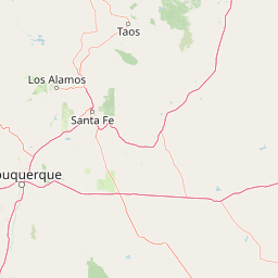
Map view of Jemez National Recreation Area

Use this park location map to pinpoint Jemez National Recreation Area in United States of America, understand its exact geographic position, and read its mapped placement within the surrounding landscape more clearly.

Pigeon | © OpenStreetMap contributors

Location context for Jemez National Recreation Area

New MexicoSandoval County
Park atlas

Compare adjacent volcanic terrain, mountain forests, and regional conservation areas.

Explore Parks Near Jemez National Recreation Area and Surrounding Protected Lands

Browse protected areas and national forests adjacent to Jemez National Recreation Area to evaluate regional mountain geography. Comparing neighboring volcanic terrain and river canyons provides deeper context on northern New Mexico ecosystems.
Watercolor painting of a gentle, rolling landscape with a small stream, a small waterfall, and scattered trees under a soft, light sky.
Protected landscapeNew Mexico
About 0 km away#1 closest

East

Santa Fe National Forest: Geographic Atlas and Protected Landscape Overview

New Mexico mountain geography and wilderness mapping

Santa Fe National Forest spans more than 1.5 million acres of Northern New Mexico, featuring a dramatic transition from canyon river systems to the high elevations of the Pecos Wilderness. This protected landscape contains a complex network of forest districts across the Jemez and Sangre de Cristo Mountains, defined by volcanic plateaus, alpine basins, and seasonal aspen forests. Use this resource to understand the park boundaries, regional mountain geography, and the interconnected nature of these protected lands.

Area
6,306.83 km²
Established
1915
Relief
Mountain
Access
Easy access
A pale, minimalist watercolor painting showing a horizontal landscape with a thin treeline in the midground and soft, blue-toned mountain peaks in the background against a white sky.
Wildlife reserveSandoval County
About 26 km away#2 closest

East

Dome Wilderness: Volcanic Domes and Protected Forest Geography in Sandoval County

High-desert wilderness area in the Jemez Mountains

Dome Wilderness is a protected natural area in Sandoval County, New Mexico, defined by its exposed volcanic domes and dramatic post-fire recovery landscape. Sitting within the Santa Fe National Forest, the terrain preserves both natural geological features and significant prehistoric archaeological sites. Its unique visual character, shaped by the 1996 Dome Fire, contrasts open, fire-swept slopes with dense coniferous forest stands.

Area
21 km²
Established
1980
IUCN
Ib
Relief
Mountain
A minimalist watercolor painting depicting soft green rolling hills in the foreground and faded pink mountain ridges in the background on a white paper background.
Protected areaNew Mexico
About 110 km away#3 closest

South

Manzano Mountain Wilderness: Rugged Protected Landscapes in Central New Mexico

Canyon-scarred mountain geography and forest ecosystems.

Manzano Mountain Wilderness is a significant protected area defined by its deep, radiating canyons and compressed elevational ranges. From pinyon-juniper foothills to the spruce-fir heights of the crest, this landscape offers a detailed look at the varied natural terrain found within the Cibola National Forest in New Mexico.

Area
149.23 km²
Established
1978
IUCN
Ib
Relief
Mountain
Watercolor painting of soft, layered mountain ranges behind green hills and patches of evergreen trees on a white background.
Protected landscapeColorado
About 136 km away#4 closest

North

Rio Grande National Forest: Atlas and Geographic Profile of a Southern Colorado Landscape

Watershed geography and Continental Divide terrain analysis.

Rio Grande National Forest represents an immense protected landscape encompassing diverse terrain from high desert steppe to rugged alpine peaks. This profile details the forest's hydrological significance as the source of the Rio Grande and its role as a massive ecological transition zone in the Mountain West. Examine the boundaries and mountain geography that define this critical protected area.

Area
7,500 km²
Established
1908
Relief
Mountain
Climate
Boreal
Protected landscapeColorado
About 141 km away#5 closest

Northwest

San Juan National Forest: Geographic Overview of a Major Southern Colorado Protected Landscape

Mapped terrain across the Southern San Juan Mountains

San Juan National Forest represents a massive protected landscape in western Colorado, defined by its rugged alpine peaks, dense conifer forests, and glacial valleys. This atlas entry details the forest boundary, its position along the Continental Divide, and the surrounding transition into the Colorado Plateau. It provides a structured look at the terrain that connects diverse ecosystems, from high-altitude tundra to expansive mesa country, within one of the largest national forests in the American West.

Area
7,603.42 km²
Established
1905
Relief
Mountain
Climate
Alpine
Watercolor painting of a green forest, calm water, and distant mountain silhouettes against a light sky.
Wildlife reserveNew Mexico
About 147 km away#6 closest

Northeast

Latir Peak Wilderness: Mapped Geography of the Sangre de Cristo Mountains

High-elevation wilderness reserves in northern New Mexico

Latir Peak Wilderness presents a distinct vertical landscape within the northern Sangre de Cristo Mountains. This protected area features a unique combination of high-altitude summits, rounded alpine mesas, and cold-water trout habitats. Mapped terrain includes the significant Lake Fork of Cabresto Creek drainage and dense conifer forests that define this 20,506-acre wilderness unit.

Area
82.98 km²
Established
1980
IUCN
Ib
Relief
Mountain
A horizontal watercolor illustration of a wide, open prairie landscape featuring soft green hills, sparse shrubs, and grasses against a pale background.
Protected landscapeNew Mexico
About 208 km away#7 closest

East

Kiowa National Grassland: Protected Landscapes, Canyon Terrain, and Prairie Geography

Northeastern New Mexico shortgrass prairie and river canyon systems.

Kiowa National Grassland represents a distinctive protected landscape within the southwestern Great Plains, featuring a mix of rolling steppe, pinyon-juniper woodland, and the deep gorges of the Canadian River Canyon. This area offers significant insight into the regional geography of New Mexico, where historic Santa Fe Trail corridors and seasonal playa lakes define the local terrain and ecosystem.

Area
554.95 km²
Established
1960
Relief
Upland
Climate
Temperate
Watercolor painting of a serene mountain landscape featuring rolling hills, coniferous trees, and a lake in the foreground, rendered in light pastel tones.
Protected landscapeColorado
About 213 km away#8 closest

Northeast

San Isabel National Forest: Geographic Overview and Protected Mountain Landscape Atlas

Central Colorado alpine terrain and designated wilderness areas

Spanning eleven counties in central Colorado, San Isabel National Forest serves as a cornerstone of the Southern Rocky Mountains. The forest landscape is dominated by the Sawatch and Sangre de Cristo ranges, offering a unique atlas of alpine tundra, dense coniferous forests, and high-altitude peaks that define the character of the region. This protected area provides a vital habitat and a vast, rugged environment characterized by volcanic formations like the Spanish Peaks and glacial geological features.

Area
4,533.42 km²
Established
1902
Relief
Mountain
Climate
Alpine

Common questions about visiting, size, designation, and location context for Jemez National Recreation Area

Jemez National Recreation Area FAQs for park facts, access, geography, and protected area context

Find quick answers about Jemez National Recreation Area, including protected-area facts, park geography, trail and visitor context, and how the park fits into its surrounding country and regional landscape.
MoriAtlas Explorer

Continue Your Protected Areas Search Across the Global Atlas

Deepen your exploration by continuing the structured search for national parks and protected areas worldwide. Utilize the comprehensive filtering capabilities to compare different conservation landscapes and refine your understanding of global park geography. Discover more about the distribution and characteristics of protected natural areas.

Global natural geography