Mori Atlas logo
Nature reserveKakushöhle

Examining the mapped boundaries, geological terrain, and historical significance of this Eifel nature reserve

Kakushöhle Nature Reserve: A Detailed Geographic Atlas of the Eifel Travertine Landscape

Kakushöhle represents a unique protected landscape within the Eifel region of North Rhine-Westphalia, centered on an isolated travertine hill and its extensive open cavern system. This nature reserve preserves a storied archaeological site documented for its Neanderthal presence and later use as a Roman-era refuge. Its geographic footprint encompasses the dramatic rock faces of the Kakusfelsen and the plateau above, offering a distinctive perspective on regional karst and travertine terrain development.

caveopen cavetravertinekarstarchaeological sitepaleolithic

Kakushöhle

Nature reserve

Park overview

Structured park overview, official facts, and landscape profile for Kakushöhle

Kakushöhle park facts, protected area profile, and essential visitor context

Review the core facts for Kakushöhle, including designation, size, terrain, visitor scale, habitats, and operating context in one park-focused overview.

About Kakushöhle

The Kakushöhle is carved into the Kakusfelsen, a standalone hill of travertine and calcareous tufa in the northern Eifel foothills of North Rhine-Westphalia. Although the rock is not large, its geology is unusual for the region. Rather than the dolomite and limestone more typical of Eifel caves, the Kartstein is composed of calcium carbonate that precipitated from karst spring water, likely drawn from sources higher in the surrounding uplands. The result is a soft but durable stone that holds the wide, low roof of the main cave chamber and gives the surrounding walls their pale, layered appearance.

Inside, the Kakushöhle opens into the chamber known as the Große Kirche, a space up to about 15 meters high and 30 meters wide, which gives the cave its status as one of the largest open caves in the Eifel. From this hall, a smaller side room called the Dunkle Kammer extends into the rock. A second, much smaller opening, the Kaltes Loch, lies roughly 50 meters to the north. The rock itself carries a plateau about 150 meters long, bounded to the west by a section wall that converted the natural defensive advantages of the cliff edges into a proper refuge in times of danger. The entire complex of rock, plateau, and cave openings has been protected as the nature reserve Kartsteinhöhlen mit Kakushöhle since 1932, emphasizing its value as a combined geological, archaeological, and landscape feature rather than merely a cave.

The Kakushöhle is not a show cave with developed pathways and lighting. Entrance is free, and visitors bring their own light or use daylight from the broad mouth of the cave. Modern safety work in 1977 added supports to stabilize the roof, and the floor of the main chamber was leveled during wartime use in 1944 and 1945. Outside, a circular walking trail links the cave entrance, the small cave, the section wall, and the remains of a bust of Kaiser Wilhelm II that once stood on the plateau, while interpretive panels explain both the geological story and the long human history of the place.

The cave lies within easy reach of the town of Mechernich and the broader Mechernicher Voreifel, an area long associated with the Eifel aqueduct and Roman lead mining. Together with the nearby Herkelstein, the Kartstein forms part of a small cluster of distinctive rock formations that give this part of the northern Eifel its characteristic landscape of isolated forested hills and quiet valleys.

Quick facts and research context for Kakushöhle

The Kakushöhle lies within the Kakusfelsen, a travertine and calcareous tufa rock formation of roughly 300,000 years in age, about 400 meters above sea level in the Mechernicher Voreifel area. The rock rises up to about 18 meters tall, carries a plateau about 150 meters long, and contains a main cave chamber reaching up to 15 meters high and 30 meters wide.

The site is part of the nature reserve Kartsteinhöhlen mit Kakushöhle, designated in 1932 and covering around 5.8 hectares. The cave is freely accessible, has no lighting, and is reached by a short walk from a parking area along the L115 road. Its principal modern significance lies in its Ice Age faunal record, its evidence of repeated prehistoric human use, and the section wall that once made the overlying plateau into a refuge in late antiquity.

Protection and recognition

Explore the documented 1932 establishment timeline and management scope for Kakushöhle

Kakushöhle Protection Status and Designated Terrestrial Conservation History

Kakushöhle maintains a documented terrestrial protection status established in 1932 across local conservation records. Structured database entries outline the formal designation history and management scope associated with this protected landscape.

Protection details

Protection scope
Terrestrial
Designated year
1932
Transboundary protection
No
Park context

Deeper park guide and search-rich context for Kakushöhle

Kakushöhle history, landscape, wildlife, and travel context

Explore Kakushöhle through its history, landscape character, ecosystems, wildlife, conservation priorities, cultural context, and seasonal travel timing in a structured park guide built for atlas discovery and search intent.

Why Kakushöhle stands out

The Kakushöhle is best known as a paleontologically rich open cave in the Eifel, with documented Neanderthal and later Ice Age human presence and an exceptional faunal record that includes mammoth, woolly rhinoceros, cave bear, cave lion, steppe bison, reindeer, giant deer, and musk ox. The cave and its rock are equally recognized for their role as a refuge site in late Roman times, when the plateau above was fortified with a section wall against Frankish incursions in the fourth century. The site is also distinctive for the unusual combination of an open, easily visited cave set within a compact travertine rock formation that itself forms a small plateau, allowing visitors to move from cave interior to elevated open ground within a single short walk. The legend of the giant Kakus, the subject of a localized retelling of the Hercules and Cacus myth, adds a strong cultural identity to the place.
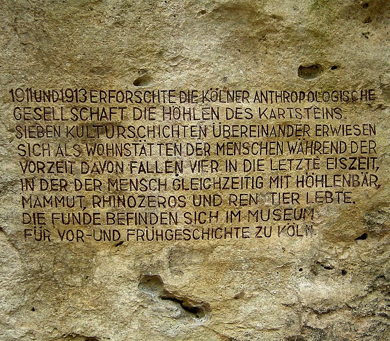
A close up view of an inscription carved directly into the rough, light-colored limestone rock of the Kakushöhle cave, detailing the history of archaeological findings at the site.
Historical inscription on the rock wall of the Kakushöhle cave system, describing archaeological excavations conducted in 1911 and 1913.

Kakushöhle history and protected-area timeline

The Kakushöhle has a layered human history that stretches back well into the Pleistocene. Finds in and around the cave point to visits by Neanderthals and by later Ice Age modern humans, and reindeer hunters of the Ahrensburg culture are believed to have set up camp near the cave openings in the Late Paleolithic, roughly 12,000 years ago. Bronze fibulae and iron slag from the plateau suggest use during the older La Tène period, while Roman coins indicate that the plateau functioned as a refuge in the early fourth century, when Frankish incursions made the surrounding lowlands insecure.

During the Middle Ages the cave served only briefly as human shelter. Finds cluster in the 12th century for the large cave and in the 13th and 14th centuries for the smaller one, suggesting intermittent use rather than continuous occupation. In the early modern period the rock appeared in regional mapping under names such as Roches caverneux on the Tranchot map of around 1809 and CacusHöhle on the Prussian Uraufnahme of 1846, preserving the legendary name that had already attached itself to the site.

The twentieth century brought the formal recognition of the cave as a protected site. In 1902 Crown Prince Wilhelm visited the cave, and in 1907 a bust of Kaiser Wilhelm II was erected on what became known as the Kaiserhorst above the cave. The Kakushöhle was placed under nature protection as part of the 5.8 hectare reserve Kartsteinhöhlen mit Kakushöhle in 1932, and during the Second World War the large chamber was used as an air raid shelter, a materials store for a nearby factory, and a document archive for the district administration, an episode that left the cave floor leveled. A restaurant that had stood near the entrance burned down in 1982 and was not allowed to be rebuilt.

Kakushöhle landscape and geographic character

The Kakushöhle sits within the Kakusfelsen, an isolated hill of travertine and calcareous tufa that rises roughly 18 meters above its base and sits at about 400 meters elevation within the Mechernicher Voreifel. The rock is unusually light in color and texture, with the layered appearance characteristic of spring-deposited calcium carbonate, and its surface near the cave displays the soft, eroded faces typical of older travertine outcrops.

Above the cave, the rock supports a plateau roughly 150 meters long. To the west the plateau drops away behind the section wall, while the remaining sides fall off into cliff faces that made the ground naturally defensible. From the plateau the landscape opens into the broader rolling country of the northern Eifel, a transition zone between the uplands and the lowland plain toward the Rhine, scattered with similar small rock features and patches of mixed forest.
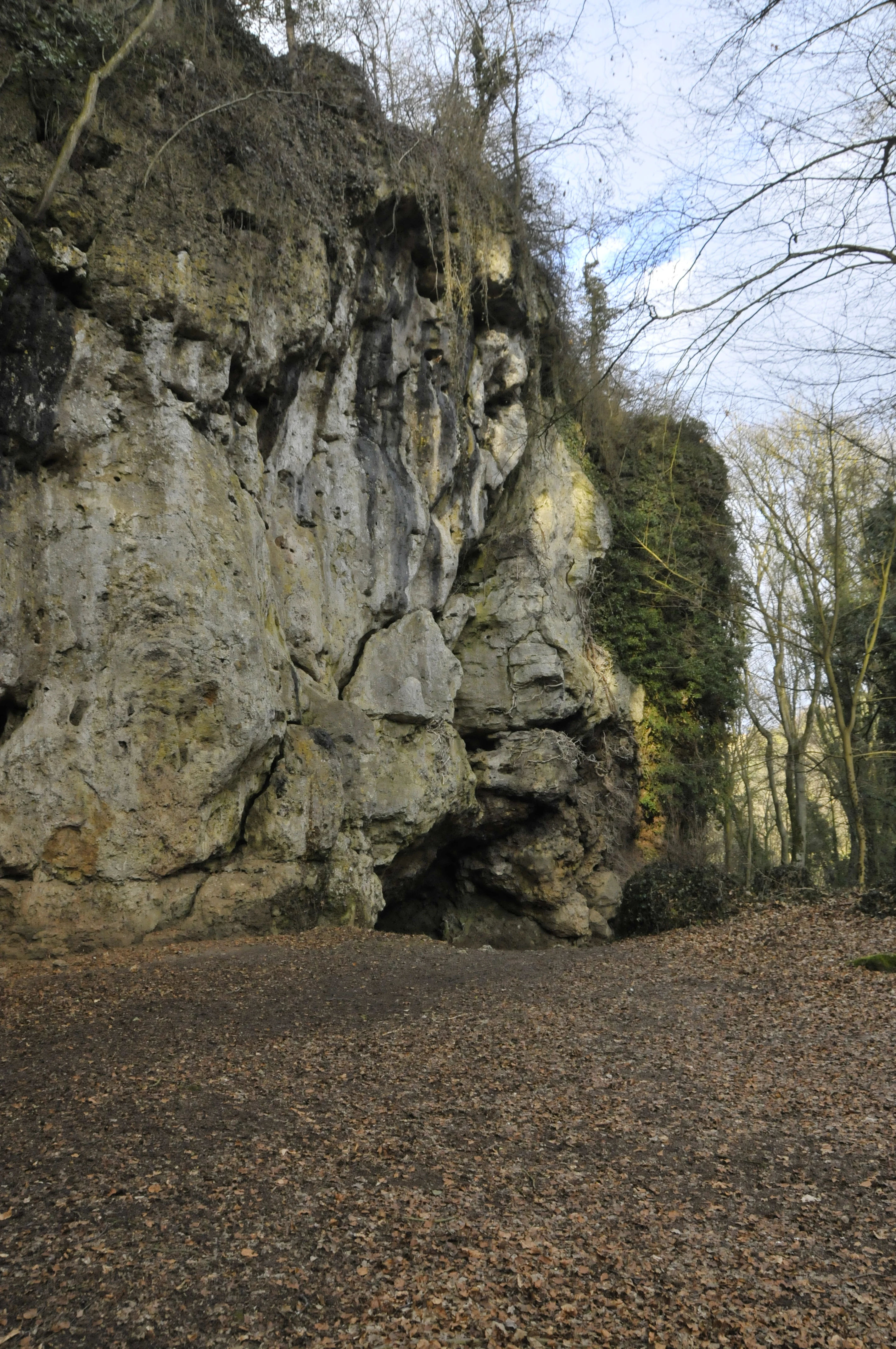
A wide angle shot of a large natural cave opening set into a limestone cliff face, surrounded by bare trees during late autumn or winter.
The main entrance to the Kakushöhle cave system, revealing its natural karst rock formation.

Kakushöhle conservation status and protection priorities

The Kakushöhle and the surrounding rock have been protected since 1932 as the nature reserve Kartsteinhöhlen mit Kakushöhle, which covers approximately 5.8 hectares. The protected status reflects the combined geological, paleontological, archaeological, and landscape value of the area: the travertine itself is unusual in the Eifel, the caves preserve Pleistocene sediments, the plateau and section wall document later prehistoric and historic use, and the rock forms a recognizable element of the regional scenery.

Conservation care at the site has focused as much on stabilizing the cave as on preserving its scientific value. The 1977 reinforcement work in the Große Kirche added supports to keep the chamber safe for visitors, and the leveling of the cave floor during wartime use in 1944 and 1945 remains a visible reminder that even protected caves are shaped by 20th century history as well as by deep time. As an open, free-access cave without lighting, the Kakushöhle is managed primarily as a low-key natural and archaeological monument rather than as a developed show cave.

Kakushöhle cultural meaning and human context

The Kakushöhle sits in a landscape shaped by long human presence. Roman lead mining and the aqueduct that once carried Eifel water to Cologne passed through the broader Mechernich area, and the cave itself shows evidence of late Roman use as a refuge during Frankish incursions. Above the cave, the bust of Kaiser Wilhelm II erected in 1907 on the Kaiserhorst, and the visit by Crown Prince Wilhelm in 1902, link the site to the imperial symbolism of its era, while the wooden restaurant and the later burning of that building in 1982 leave traces of 20th century tourism culture.

Most distinctive is the local legend of the giant Kakus, a retelling of the Hercules and Cacus myth transplanted from Italy to the Eifel by way of the Roman poet Vergil. According to the Eifel version preserved by the Mechernich mining official C. A. Eick, the robber Kakus once lived in the cave until the hero Herkules, based at the nearby Herkelstein, killed him by hurling a great rock into the opening. A second, more homely tale tells of two farmers who played cards in the cave during Holy Week and met the devil in disguise, from whom they were rescued only by a priest bearing a crucifix. Together these stories bind the cave into the regional storytelling tradition and explain the place name that has survived on maps from the early 19th century onward.
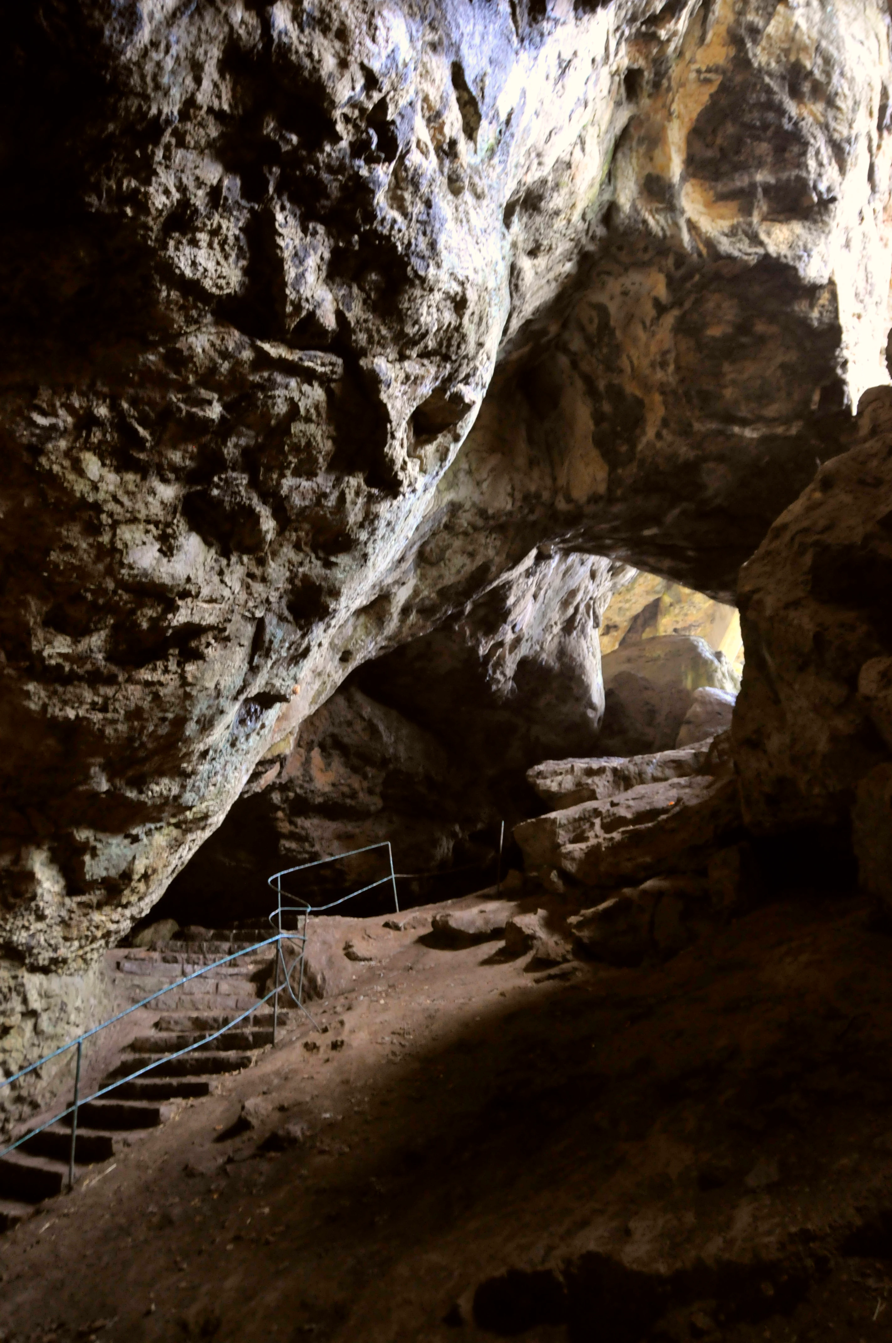
A view looking toward the entrance of a large limestone cave, featuring natural rock walls, a dirt path, and a set of stone stairs with a metal railing.
A view of the entrance area of Kakushöhle, showing the natural rock formations and a man-made staircase.

Top sights and standout views in Kakushöhle

Open main chamber up to 15 meters high and 30 meters wide, set in an isolated travertine hill; Pleistocene faunal record including mammoth, woolly rhinoceros, cave bear, and cave lion; documented Neanderthal and Upper Paleolithic human presence, plus later use as a late Roman refuge; a 150 meter plateau with a reconstructed section wall forming an ancient Fliehburg; freely accessible cave reached by a barrier-free walking loop from a roadside parking area; strong local legend identity tied to the Hercules and Cacus myth.
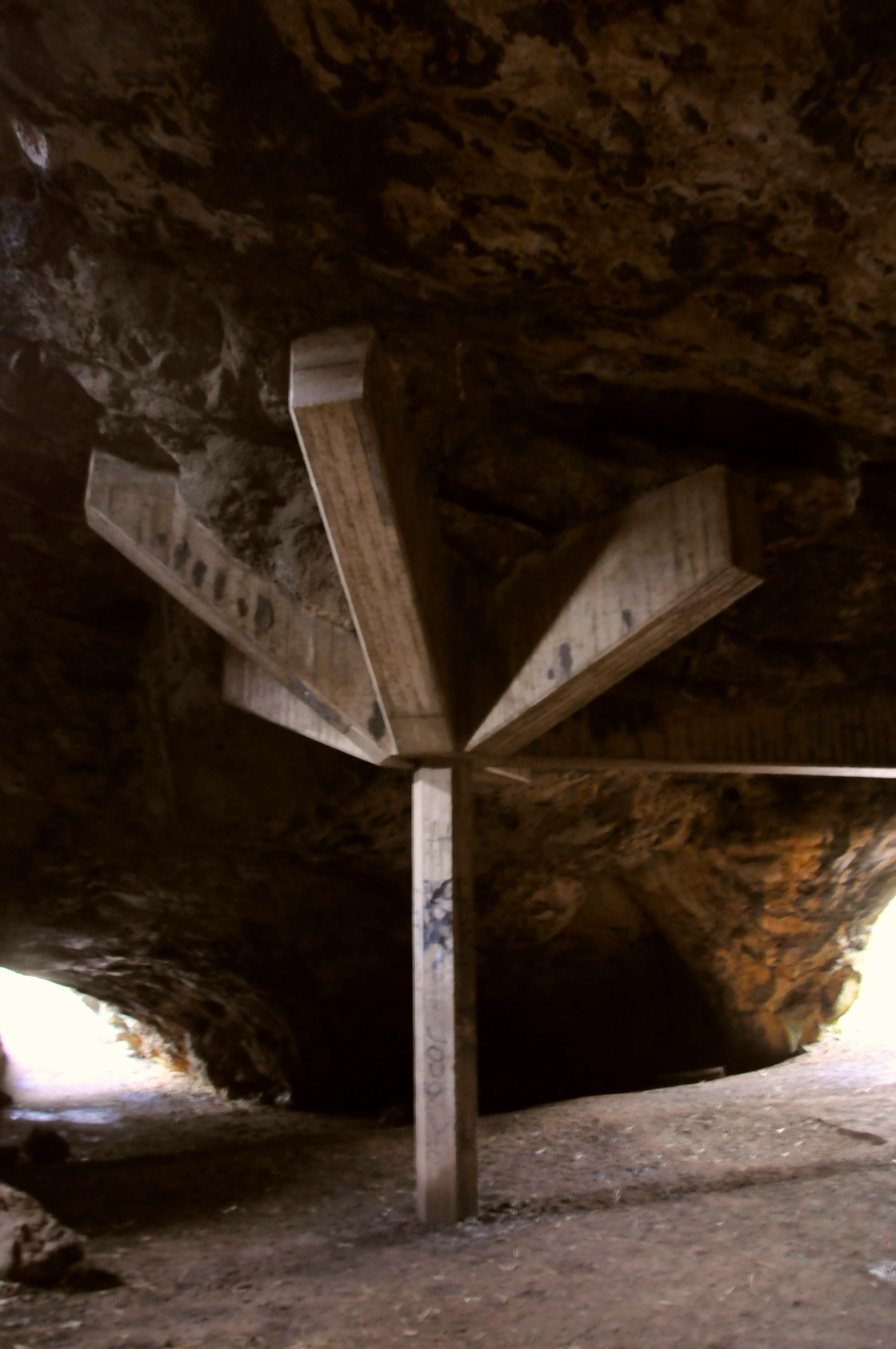
A thick, multi-armed wooden support beam holding up the ceiling inside the entrance of a karst cave, with natural light entering from the sides.
A view inside the entrance of the Kakushöhle cave system, highlighting the structural support beam.

Best time to visit Kakushöhle

The Kakushöhle can be visited year round as an open, free-access cave with no lighting. Late spring through early autumn tends to be the most comfortable period, when the approach path from the café is dry and the broad cave mouth allows easy movement without artificial light. Winter visits are possible but require a torch, and the bare deciduous plateau above the cave looks stark in the colder months, which can either be an advantage or a drawback depending on whether the visitor wants clear views of the rock formation or a softer, forested setting.

Monthly climate preview

Review measured monthly weather averages and historical temperature ranges for Kakushöhle

Kakushöhle Climate Normals and Long Term Temperature and Precipitation Patterns

Historical records from 1991 to 2020 establish long term monthly temperature and precipitation normals for Kakushöhle based on representative coordinate sampling at an elevation of 370 meters. Accessing the complete twelve month profile provides detailed metrics on average minimum and maximum temperatures across the entire annual cycle.
Annual mean9 °C
0 °C18 °C
Jan
Feb
Mar
Apr
May12°
Jun15°
Jul18°
Aug18°
Sep14°
Oct
Nov
Dec
Warmest month
July

17.9 °C

Coolest month
January

0 °C

Wettest month
June

2.5 mm/day

Driest month
April

1.6 mm/day

Park location guide

Geography guide, regional context, and park location map for Kakushöhle

Kakushöhle park geography, regions, and map view in Germany

Understand where Kakushöhle sits in Germany through a broader geographic reading of the surrounding landscape, nearby location context, and its mapped position within the national park landscape.

How Kakushöhle fits into Germany

Germany is a federal republic in Western and Central Europe with a population of over 83 million across sixteen constituent states. It is Europe's largest economy by nominal GDP and a major global exporter and importer. The capital is Berlin, and the country borders Denmark, Poland, Czech Republic, Austria, Switzerland, France, Luxembourg, Belgium, and the Netherlands.

Wider geography shaping Kakushöhle in Germany

Germany is located in Western and Central Europe, spanning 357,022 km². It borders Denmark to the north, Poland and the Czech Republic to the east, Austria and Switzerland to the south, and France, Luxembourg, Belgium, and the Netherlands to the west. The country has coastlines on the Baltic Sea and North Sea to the north, with the Alps located in the southern region.

Map view of Kakushöhle

Use this park location map to pinpoint Kakushöhle in Germany, understand its exact geographic position, and read its mapped placement within the surrounding landscape more clearly.

Pigeon | © OpenStreetMap contributors

Location context for Kakushöhle

North Rhine-Westphalia

Visual exploration of travertine rock formations, cave chambers, and surrounding terrain

Kakushöhle Photos and Landscape Scenery in the Eifel Protected Area

Photographic records reveal the dramatic scale of the travertine rock formation and open cave chambers that define the protected landscape. Visual documentation of the terrain and surrounding Eifel region helps researchers understand the geological and archaeological context of the site.

A close up view of an inscription carved directly into the rough, light-colored limestone rock of the Kakushöhle cave, detailing the history of archaeological findings at the site.

A low-angle view inside the Kakushöhle cave, showing a large limestone opening, a sandy ground, and stone steps with a metal handrail leading deeper into the cavern.

A wide angle shot of a large natural cave opening set into a limestone cliff face, surrounded by bare trees during late autumn or winter.

Interior view of the Kakushöhle cave looking towards the bright exit, with a stone path and stairs visible between large limestone walls.

A view looking toward the entrance of a large limestone cave, featuring natural rock walls, a dirt path, and a set of stone stairs with a metal railing.

A thick, multi-armed wooden support beam holding up the ceiling inside the entrance of a karst cave, with natural light entering from the sides.

A circular outdoor grill area with stone fire pit and wooden benches, surrounded by a simple wooden railing and leaf-covered ground in a forest setting.

Park atlas

Compare nearby nature reserves, geological formations, and surrounding regional landscapes

Explore Other Parks Near Kakushöhle and Protected Areas Across the Eifel Region

Continue exploring protected natural areas and regional park geography adjacent to Kakushöhle. Compare similar geological formations and protected landscapes across the surrounding Eifel terrain.
A horizontal watercolor illustration showing red sandstone rock formations nestled among stylized green trees against a pale yellow background.
Nature reserveMechernich
About 6.7 km away#1 closest

North

Katzensteine Nature Reserve: Red Sandstone Formations and Archaeological Heritage in Mechernich

Protected geological terrain in the North Rhine-Westphalia Eifel region

Katzensteine stands as a distinctive protected landscape defined by 15 meter high red Middle Buntsandstein cliffs. Beyond its geological status, the nature reserve links Stone Age archaeology and Roman industrial history within the Veybach valley. This area provides essential context for the broader sandstone belt spanning the Eifel, showcasing the interplay between natural erosion, sediment layering, and long-standing human presence in the German landscape.

Established
1937
Relief
Upland
Climate
Temperate
Access
Access unknown
Watercolor illustration of rolling green hills and meadows with patches of pink and yellow flowers
National parkNorth Rhine-Westphalia
About 7.9 km away#2 closest

Northwest

Eifel National Park: North Rhine-Westphalia Protected Area Atlas

Explore mapped boundaries and regional geography.

Gain a structured understanding of Eifel National Park, a key protected area within Germany's North Rhine-Westphalia region. This page focuses on its geographic identity, detailing mapped boundaries and offering context within the state's broader natural landscapes. MoriAtlas enhances your exploration by presenting Eifel National Park as a distinct entity within a larger geographic framework, ideal for atlas-based research and understanding protected land distribution.

Area
107 km²
Established
2004
IUCN
II
Relief
Upland
A horizontal watercolor painting depicting a gentle, hazy green landscape with rolling hills, a line of trees, and a foreground meadow.
Protected landscapeNorth Rhine-Westphalia
About 9.3 km away#3 closest

Northeast

Naturpark Rheinland: Geography and Protected Area Overview in North Rhine-Westphalia

A complex metropolitan nature park and lake district

Naturpark Rheinland represents a distinct convergence of reclaimed lignite mining landscapes, quiet lowland forests, and floodplain wetlands. Its mapped boundaries reveal a diverse terrain of ridges and river valleys that define the environmental character of the Cologne-Bonn metropolitan region.

Area
1,045 km²
Established
1959
Relief
Upland
Climate
Temperate
A watercolor painting of a gentle, rolling landscape with soft-focus hills in the distance and a cluster of light green and yellow trees in the middle ground.
Nature reserveNorth Rhine-Westphalia
About 10 km away#4 closest

Northeast

Kalkarer Moor / Tongrube Toni: Wetland Mosaic and Protected Reserve in North Rhine-Westphalia

A study of calcareous fens and industrial landscape recovery.

Located in the Euskirchen district, this nature reserve is defined by the coexistence of a centuries-old calcareous flat mire and an abandoned clay pit now transformed into a vibrant groundwater wetland. The site provides a distinct look at hydrological recovery, featuring a dense patchwork of reedbeds, damp meadows, and successional woodland that remains ecologically vital for regional flora and avian habitats.

Area
0.496 km²
Established
1935
Relief
Lowland
Climate
Temperate
Nature reserveNorth Rhine-Westphalia
About 14 km away#5 closest

Southeast

Vogelschutzgebiet Ahrgebirge Nature Reserve, North Rhine-Westphalia Protected Landscape

Mapped ridge terrain and woodland habitat in the western Eifel region

The Vogelschutzgebiet Ahrgebirge serves as a significant nature reserve protecting the North Rhine-Westphalian side of the Ahrgebirge ridge. Its geography consists of dense, near-natural deciduous forests, stream-cut valleys, and deadwood habitats that provide breeding ground for specialist avian species, forming part of a larger interconnected network across the Rhenish Slate Mountains.

Area
5.8 km²
Established
2004
Watercolor painting of a soft green landscape with a stream flowing through wetlands and light hills in the distance.
Nature reserveNordrhein-Westfalen
About 17 km away#6 closest

East

Houverather Bach und Nebenbäche: Geography and Protected Brook Systems of the Ahr Eifel

A multi-parcel nature reserve spanning wet meadows and stream-side forest corridors

Houverather Bach und Nebenbäche constitutes a unique protected landscape structured around the Houverather Bach. This reserve comprises eight individual parcels that preserve essential riparian habitats, including reed-fringed fish ponds, meadowsweet-rich grasslands, and beech woodland stands. Spanning the boundary regions of the northern Ahr Eifel, this protected area highlights the importance of maintaining small-scale stream valley ecosystems within the district of Euskirchen.

Area
0.692 km²
Established
2007
Relief
Upland
Climate
Temperate
A horizontal watercolor illustration showing soft, rolling green hills, a background of distant purple mountains, and small clusters of pinkish trees.
Nature reserveNorth Rhine-Westphalia
About 19 km away#7 closest

South

Lampertstal und Alendorfer Kalktriften mit Fuhrbach und Mackental: Eifel Protected Landscapes

A diverse nature reserve in North Rhine-Westphalia featuring karst geography

This extensive nature reserve in the Eifel region serves as a crucial habitat for limestone flora, featuring the largest juniper conservation site in North Rhine-Westphalia. Spanning a complex of valleys and hills, the area demonstrates a distinctive interaction between karst geology, medieval historical sites, and rare calcareous ecosystems that support a wide range of protected species.

Area
11.01 km²
Established
2007
Relief
Upland
Climate
Temperate
Nature reserveNorth Rhine-Westphalia
About 20 km away#8 closest

Southwest

Simmeler Bach Nature Reserve: Geographic Atlas and Protected Landscape Overview

Riparian stream valleys and forest habitats in North Rhine-Westphalia

Simmeler Bach serves as a vital nature reserve and restored stream corridor in the Eifel district of Euskirchen. The protected area features a diverse landscape including open wet meadows, alder-lined brook banks, and rare mat-grass sward, all integrated into a wider regional network of conserved riparian habitats across western Germany.

Area
1.086 km²
Established
2001
Relief
Upland
Climate
Temperate

Common questions about visiting, size, designation, and location context for Kakushöhle

Kakushöhle FAQs for park facts, access, geography, and protected area context

Find quick answers about Kakushöhle, including protected-area facts, park geography, trail and visitor context, and how the park fits into its surrounding country and regional landscape.
MoriAtlas Explorer

Continue Your Protected Areas Search Across the Global Atlas

Deepen your exploration by continuing the structured search for national parks and protected areas worldwide. Utilize the comprehensive filtering capabilities to compare different conservation landscapes and refine your understanding of global park geography. Discover more about the distribution and characteristics of protected natural areas.

Global natural geography