Mori Atlas logo
Nature reserveKatzensteine

Tracing geological heritage and ancient cultural layers in the Eifel regional landscape

Katzensteine Nature Reserve: A Deep Dive into the Red Sandstone Landscapes of Mechernich, Germany

(Naturschutzgebiet Katzensteine)

The Katzensteine nature reserve in Mechernich serves as a pivotal point for understanding the Middle Buntsandstein geology of the Eifel region. This protected area preserves dramatic red sandstone towers shaped by centuries of weathering alongside a rich archaeological history, including Roman quarry remnants and ancient temple sites. Through structured geographic mapping, the site reveals a compact yet complex intersection of natural sediment structures and human legacy within the broader Veybach valley terrain.

sandstone formationbuntsandsteineifelnature reserverock formationgeological heritage

Katzensteine

Nature reserve

Park overview

Structured park overview, official facts, and landscape profile for Katzensteine

Katzensteine park facts, protected area profile, and essential visitor context

Review the core facts for Katzensteine, including designation, size, terrain, visitor scale, habitats, and operating context in one park-focused overview.

About Katzensteine

The Katzensteine is a modest but visually distinctive natural landmark in the northern Eifel, formed from Middle Buntsandstein sandstone that has been worn into steep, blocky cliffs by long-term weathering and erosion. The formation rises roughly 15 meters high and exposes the bedding planes of the original sand deposits, providing visitors with a clear and unusually accessible view of the geological structure of the region. Its red coloration, a result of finely distributed hematite particles, makes the outcrop visually striking against the surrounding woodland and gives the site its own particular identity within the broader Eifel landscape.

The rock group sits in the Veybach valley directly along the L 61 road between Satzvey and Mechernich, near the small village of Katzvey. Although it is a relatively compact site, the area that surrounds and protects the formation is meaningful: the nature reserve also encompasses an old, disused quarry to the northeast and the forested hillslopes around the rocks. These additions link the geology of the Katzensteine to the post-industrial and forest landscape of the Eifel, where older extraction sites often overlap with modern woodland reserves.

The wider geological context is the Buntsandstein belt that extends from Mechernich and Kall toward Nideggen. Within this belt the Katzensteine stand out both for their height and for the way their faces read as a textbook example of Middle Buntsandstein layering. The combination of accessible outcrop, distinctive color, and long history of human interest explains why the site has long been recognized as worthy of protection, first formally designated in 1937 and still listed among the nature reserves of the Mechernich area and the broader Kreis Euskirchen.

Quick facts and research context for Katzensteine

The Katzensteine lies in the Veybach valley between Mechernich and Satzvey, near the village of Katzvey in the Eifel region of North Rhine-Westphalia. The formation is a Middle Buntsandstein massif reaching heights of around 15 meters, with clearly visible sedimentary layering and the reddish color characteristic of iron oxide-rich sandstone. The site has been protected as a nature reserve (Naturschutzgebiet) since 1937 and includes not only the rock faces but also an older quarry to the northeast and the surrounding forest areas. The wider Buntsandstein belt in which the Katzensteine sits extends from Mechernich through Kall toward Nideggen.

Protection and recognition

Examine official terrestrial boundaries, management frameworks, and documented recognition details.

Katzensteine Protection Status and Terrestrial Conservation Scope

Katzensteine maintains a defined terrestrial protection scope within its regional conservation framework. Documented designation records outline the structural boundaries and management context established for the area.

Protection details

Protection scope
Terrestrial
Transboundary protection
No
Park context

Deeper park guide and search-rich context for Katzensteine

Katzensteine history, landscape, wildlife, and travel context

Explore Katzensteine through its history, landscape character, ecosystems, wildlife, conservation priorities, cultural context, and seasonal travel timing in a structured park guide built for atlas discovery and search intent.

Why Katzensteine stands out

The Katzensteine is best known for its vivid red Middle Buntsandstein cliffs, shaped by weathering and erosion into blocky, steep-walled rock towers that clearly display the sedimentary layering of the original sand deposits. The reddish hue comes from fine hematite, or iron oxide, particles distributed through the sandstone, giving the formation a distinctive color in the otherwise green Eifel landscape. The reserve is equally valued for its layered cultural heritage, from Stone Age finds beneath the rocks to a Roman quarry and a votive stone tradition tied to a nearby Diana temple.
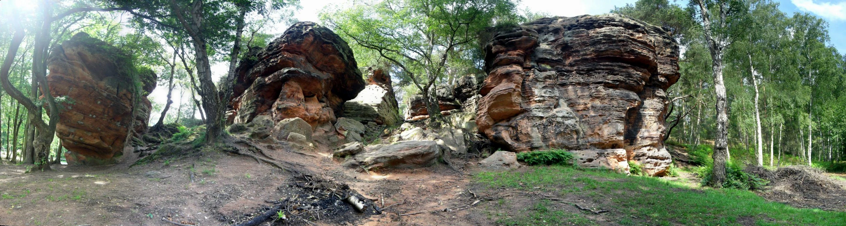
A wide-angle panoramic shot of several large, weathered sandstone rock towers surrounded by a forest of green deciduous trees.
A panoramic view of the Katzensteine sandstone rock formations in Germany.

Katzensteine history and protected-area timeline

The Katzensteine has been formally protected as a nature reserve since 1937, making it one of the longer-standing small conservation areas in the northern Eifel. The protection is not only ecological but also, in practice, archaeological, because the rocks have served as a sheltered site and a stone resource across many centuries.

Archaeological investigation below the formation was conducted by H. Löhr in 1970 and 1971. The resulting finds included Stone Age artifacts that indicate the rocks were used as a shelter or meeting point by prehistoric hunter-gatherers who hunted red deer, elk, and roe deer in the surrounding landscape. The same excavations revealed a small Roman quarry that had been worked from the first half of the first century CE, likely to supply a nearby villa rustica in the Mechernich area.

A few hundred meters from the rocks, archaeologists also identified the remains of a small first-century temple dedicated to the goddess Diana. Votive stones associated with that temple were carved from the very Buntsandstein of the Katzensteine, linking the geological resource directly to the religious and daily life of the Romanized local population. These sequences of use and the site's protected status since the late 1930s together give the Katzensteine a layered history that stretches from prehistory through the Roman period into the modern conservation era.

Katzensteine landscape and geographic character

The Katzensteine landscape is defined by a compact but dramatic sandstone outcrop rising from the floor of the Veybach valley. The rocks are blocky and rugged, with steep walls on the south, east, and west sides that face the valley and the surrounding slopes, while the formation as a whole sits relatively low in the local topography, emphasizing its vertical relief rather than its absolute height.

The visible layering in the rock faces is one of the most distinctive landscape features. These planar structures record the original deposition of sand and have been re-exposed by the gradual washing away of weathered and dissolved material, which has sculpted the present-day shape of the formation. The Buntsandstein here is classed as Middle Buntsandstein and takes part in a broader belt of similar sandstone that runs from Mechernich through Kall toward Nideggen, making the Katzensteine a representative and visually clear expression of that regional geology.

The color of the rock is a defining part of the landscape experience. Fine hematite particles distributed through the sandstone give it a warm reddish tone that contrasts strongly with the surrounding forest green, especially in low-angle sunlight. Around the formation, the nature reserve extends into older quarry areas to the northeast and into woodland that softens the transition between the valley floor and the higher ground of the Eifel.

Katzensteine ecosystems, habitats, and plant life

As a small nature reserve, the Katzensteine functions primarily as a protected geological and woodland site rather than a large-scale habitat zone. The reserve encompasses the sandstone formation itself, an associated older quarry to the northeast, and the surrounding forest areas, creating a connected patchwork of rocky outcrops, former extraction sites, and wooded slopes.

The wooded setting around the rocks provides habitat continuity with the broader Eifel forest landscape, linking the reserve to the network of forests that extends across the Veybach valley and the wider Buntsandstein belt between Mechernich, Kall, and Nideggen. The presence of the rock face, the disturbed ground around the old quarry, and the shaded forest edge together generate a varied microhabitat mosaic for species tied to rocky terrain, woodland interior, and transitional forest edge.

The protected status, in place since 1937, reflects the value of this combination rather than any single ecosystem type. The site is managed to preserve both its geological exposures and its surrounding woodland character, allowing the natural erosion processes that shape the sandstone to continue in a setting that also supports forest-dependent plants and animals.

Katzensteine wildlife and species highlights

The source material does not provide detailed wildlife inventories for the Katzensteine, and specific species lists for the reserve are not available in the provided text. Game animals present in the prehistoric surroundings of the rocks, including red deer, elk, and roe deer, are documented through archaeological finds rather than through modern fauna records. The contemporary wildlife character of the site is shaped by its forested setting and rocky outcrops within the broader Eifel landscape, but detailed species-level information cannot be stated with the source material at hand.

Katzensteine conservation status and protection priorities

The Katzensteine has been a designated nature reserve (Naturschutzgebiet) since 1937, giving it one of the longer conservation histories among the small protected sites of the northern Eifel. The reserve protects not only the sandstone rock formation but also a former quarry to the northeast and the surrounding woodland, recognizing the value of the combined geological and forest landscape rather than the rock alone.

The conservation profile of the site is shaped by the broader Buntsandstein belt that runs through Mechernich, Kall, and toward Nideggen. Within this belt the Katzensteine stand out for their accessible exposure of Middle Buntsandstein layering and their distinctive reddish color, characteristics that depend on the continued protection of the outcrop from quarrying, development, and uncontrolled vegetation overgrowth. Protection also helps preserve the visual and geological relationship between the rocks and the Veybach valley landscape in which they sit.

The site's long protection history, combined with its documented prehistoric and Roman-era human use, makes it a place where geological conservation, archaeological preservation, and forest habitat protection converge. It is listed among the nature reserves of Mechernich and of the Kreis Euskirchen, placing it within a larger regional network of small protected areas that collectively maintain the natural character of the Eifel.

Katzensteine cultural meaning and human context

The Katzensteine carries a layered human history that begins well before the modern conservation era. Archaeological excavations beneath the rocks in 1970 and 1971, led by H. Löhr, recovered Stone Age artifacts that show prehistoric hunter-gatherers used the site while pursuing red deer, elk, and roe deer in the surrounding landscape. This places the formation within a much older network of sheltered rock sites and hunting grounds in the Eifel.

The Roman period adds a second, very different cultural layer. A small quarry at the base of the rocks was operated from the first half of the first century CE, probably to supply stone for a nearby villa rustica. Roughly 400 meters from the Katzensteine, archaeologists located the remains of a small first-century temple dedicated to Diana. Some of its votive stones were carved from the Buntsandstein of the Katzensteine themselves, tying the geology of the site directly to local religious practice.

In the modern era, the site has become part of the regional cultural geography of the northern Eifel, recognized both for its natural appearance and for the archaeological sequences it preserves. Its formal protection since 1937 reflects a long-standing local and regional appreciation of the rocks as a heritage landscape as well as a natural one.

Top sights and standout views in Katzensteine

A protected Middle Buntsandstein rock formation up to roughly 15 meters high, with steep walls on three sides and clearly visible sedimentary layering shaped by long-term weathering of the sandstone. The fine hematite content gives the rocks a distinctive red color that contrasts with the surrounding Eifel woodland, while the adjacent old quarry and the broader Buntsandstein belt extending toward Nideggen give the site clear geological context. Layered above and around these natural features are Stone Age hunter-gatherer remains and a first-century Roman quarry tied to a nearby Diana temple, making the Katzensteine a compact but unusually information-rich cultural and natural landscape.

Best time to visit Katzensteine

The Katzensteine is best appreciated when the red color of the sandstone reads clearly against the surrounding forest and when the rock faces are accessible without weather-related risk. Spring and early summer, when foliage is still relatively open and the woodland around the rocks is lively, tend to bring out the contrast between the reddish cliffs and the green setting. Late autumn and winter can also be rewarding for visitors interested primarily in the geology, since bare trees and lower vegetation offer more open views of the formation and its layering. As with any small rock and forest reserve, wet or icy conditions on the slopes deserve caution.


Monthly climate preview

Track measured temperature ranges and precipitation patterns across twelve monthly periods

Katzensteine Climate Normals and Long Term Weather by Month

Representative coordinates near Mechernich record historical temperature extremes and monthly precipitation averages spanning multiple decades from NASA Power data. Exploring the complete meteorological profile reveals full monthly variations in average minimum and maximum thresholds.
Annual mean9 °C
0 °C18 °C
Jan
Feb
Mar
Apr
May12°
Jun15°
Jul18°
Aug18°
Sep14°
Oct
Nov
Dec
Warmest month
July

17.9 °C

Coolest month
January

0 °C

Wettest month
June

2.5 mm/day

Driest month
April

1.6 mm/day

Park location guide

Geography guide, regional context, and park location map for Katzensteine

Katzensteine park geography, regions, and map view in Germany

Understand where Katzensteine sits in Germany through a broader geographic reading of the surrounding landscape, nearby location context, and its mapped position within the national park landscape.

How Katzensteine fits into Germany

Germany is a federal republic in Western and Central Europe with a population of over 83 million across sixteen constituent states. It is Europe's largest economy by nominal GDP and a major global exporter and importer. The capital is Berlin, and the country borders Denmark, Poland, Czech Republic, Austria, Switzerland, France, Luxembourg, Belgium, and the Netherlands.

Wider geography shaping Katzensteine in Germany

Germany is located in Western and Central Europe, spanning 357,022 km². It borders Denmark to the north, Poland and the Czech Republic to the east, Austria and Switzerland to the south, and France, Luxembourg, Belgium, and the Netherlands to the west. The country has coastlines on the Baltic Sea and North Sea to the north, with the Alps located in the southern region.

Map view of Katzensteine

Use this park location map to pinpoint Katzensteine in Germany, understand its exact geographic position, and read its mapped placement within the surrounding landscape more clearly.

Pigeon | © OpenStreetMap contributors

Explore detailed imagery of the protected sandstone towers and surrounding Eifel woodland environment.

Katzensteine Photos and Landscape Scenery: Visualizing the Red Buntsandstein Cliffs

Visual documentation reveals the distinctive red sedimentary layering and weathered rock formations defining the protected landscape around Katzensteine. Studying these detailed habitat and terrain views helps visitors understand the unique geological character of the valley floor.

A wide-angle panoramic shot of several large, weathered sandstone rock towers surrounded by a forest of green deciduous trees.

A large, weathered sandstone rock formation with deep horizontal layering and mossy textures, surrounded by deciduous trees in a forest setting.

Park atlas

Compare regional protected areas and geological terrain across the Eifel region

Explore Parks Near Katzensteine and Surrounding Protected Landscapes

Browse nearby national parks and protected areas sharing similar sandstone geology and valley terrain. Compare regional conservation landscapes to expand discovery beyond Katzensteine.
A horizontal watercolor painting depicting a gentle, hazy green landscape with rolling hills, a line of trees, and a foreground meadow.
Protected landscapeNorth Rhine-Westphalia
About 3.3 km away#1 closest

Northeast

Naturpark Rheinland: Geography and Protected Area Overview in North Rhine-Westphalia

A complex metropolitan nature park and lake district

Naturpark Rheinland represents a distinct convergence of reclaimed lignite mining landscapes, quiet lowland forests, and floodplain wetlands. Its mapped boundaries reveal a diverse terrain of ridges and river valleys that define the environmental character of the Cologne-Bonn metropolitan region.

Area
1,045 km²
Established
1959
Relief
Upland
Climate
Temperate
A watercolor painting of a gentle, rolling landscape with soft-focus hills in the distance and a cluster of light green and yellow trees in the middle ground.
Nature reserveNorth Rhine-Westphalia
About 6.4 km away#2 closest

East

Kalkarer Moor / Tongrube Toni: Wetland Mosaic and Protected Reserve in North Rhine-Westphalia

A study of calcareous fens and industrial landscape recovery.

Located in the Euskirchen district, this nature reserve is defined by the coexistence of a centuries-old calcareous flat mire and an abandoned clay pit now transformed into a vibrant groundwater wetland. The site provides a distinct look at hydrological recovery, featuring a dense patchwork of reedbeds, damp meadows, and successional woodland that remains ecologically vital for regional flora and avian habitats.

Area
0.496 km²
Established
1935
Relief
Lowland
Climate
Temperate
Nature reserveNorth Rhine-Westphalia
About 6.7 km away#3 closest

South

Kakushöhle Nature Reserve: Atlas and Geographic Mapping of an Eifel Travertine Landscape

Geographic study of travertine cave formations and archaeological terrain in Germany

Kakushöhle constitutes an essential protected area for understanding travertine rock formation and human history within the Eifel. The site features an open cave complex nestled in the Kakusfelsen, providing a clear window into prehistoric geological and human occupation patterns across the North Rhine-Westphalia landscape.

Area
0.058 km²
Established
1932
Relief
Upland
Climate
Temperate
Watercolor illustration of rolling green hills and meadows with patches of pink and yellow flowers
National parkNorth Rhine-Westphalia
About 9.3 km away#4 closest

West

Eifel National Park: North Rhine-Westphalia Protected Area Atlas

Explore mapped boundaries and regional geography.

Gain a structured understanding of Eifel National Park, a key protected area within Germany's North Rhine-Westphalia region. This page focuses on its geographic identity, detailing mapped boundaries and offering context within the state's broader natural landscapes. MoriAtlas enhances your exploration by presenting Eifel National Park as a distinct entity within a larger geographic framework, ideal for atlas-based research and understanding protected land distribution.

Area
107 km²
Established
2004
IUCN
II
Relief
Upland
Watercolor painting of a soft green landscape with a stream flowing through wetlands and light hills in the distance.
Nature reserveNordrhein-Westfalen
About 16 km away#5 closest

East

Houverather Bach und Nebenbäche: Geography and Protected Brook Systems of the Ahr Eifel

A multi-parcel nature reserve spanning wet meadows and stream-side forest corridors

Houverather Bach und Nebenbäche constitutes a unique protected landscape structured around the Houverather Bach. This reserve comprises eight individual parcels that preserve essential riparian habitats, including reed-fringed fish ponds, meadowsweet-rich grasslands, and beech woodland stands. Spanning the boundary regions of the northern Ahr Eifel, this protected area highlights the importance of maintaining small-scale stream valley ecosystems within the district of Euskirchen.

Area
0.692 km²
Established
2007
Relief
Upland
Climate
Temperate
Nature reserveNorth Rhine-Westphalia
About 20 km away#6 closest

South

Vogelschutzgebiet Ahrgebirge Nature Reserve, North Rhine-Westphalia Protected Landscape

Mapped ridge terrain and woodland habitat in the western Eifel region

The Vogelschutzgebiet Ahrgebirge serves as a significant nature reserve protecting the North Rhine-Westphalian side of the Ahrgebirge ridge. Its geography consists of dense, near-natural deciduous forests, stream-cut valleys, and deadwood habitats that provide breeding ground for specialist avian species, forming part of a larger interconnected network across the Rhenish Slate Mountains.

Area
5.8 km²
Established
2004
Nature reserveNordrhein-Westfalen
About 22 km away#7 closest

West

Wolfs- und Wollebachtal Nature Reserve: Geographic Profile and Protected Stream Valleys

A vital deciduous forest and stream valley refuge in North Rhine-Westphalia

Wolfs- und Wollebachtal preserves a diverse mosaic of low mountain stream corridors and broadleaf forest types. This protected area connects several ecologically sensitive valley systems, offering a distinct contrast to surrounding forestry plantations through its meandering brooks, seepage springs, and preserved oak-hornbeam coppice habitats.

Area
0.487 km²
Established
1999
IUCN
IV
Relief
Upland
Protected landscapeNordrhein-Westfalen
About 24 km away#8 closest

West

Buhlert: Protected Landscape and Woodland History in Nordrhein-Westfalen, Germany

Eifel forest terrain, military heritage, and ridge geography

Buhlert presents a unique study in regional geography, standing as a continuous forest ridge that anchors a piece of the mid-elevation Eifel. This protected area integrates environmental conservation with the preservation of significant wartime bunkers, bomb craters, and historical military paths that define the surrounding woodland and terrain.

Area
6.99 km²
Established
2004
IUCN
V
Relief
Mountain

Common questions about visiting, size, designation, and location context for Katzensteine

Katzensteine FAQs for park facts, access, geography, and protected area context

Find quick answers about Katzensteine, including protected-area facts, park geography, trail and visitor context, and how the park fits into its surrounding country and regional landscape.
MoriAtlas Explorer

Continue Your Protected Areas Search Across the Global Atlas

Deepen your exploration by continuing the structured search for national parks and protected areas worldwide. Utilize the comprehensive filtering capabilities to compare different conservation landscapes and refine your understanding of global park geography. Discover more about the distribution and characteristics of protected natural areas.

Global natural geography