
Mori Atlas logo
Protected areaKapas Island

A study of tropical island topography, shoreline protection zones, and surrounding marine reef environments.

Kapas Island Protected Area: Exploring the Geography and Coastal Landscapes of Terengganu, Malaysia

Kapas Island serves as a distinct protected landscape off the coast of Terengganu, Malaysia, defined by a lush tropical jungle interior fringed by fine white sand beaches. The surrounding marine environment is anchored by a 1 nautical mile shoreline protection zone, creating a unique coastal boundary that supports diverse coral reef formations and shipwreck habitats. Beyond its recreational geography, the island remains a key site for scientific research, particularly regarding rare gastropod populations found within its interior terrain.

islandtropical islandcoral reefswhite sand beachessnorkelingscuba diving
A colorful digital illustration showing a tropical island scene with a sandy beach, calm turquoise water, rocky cliffs with a natural arch, and palm trees under a warm sunset sky.

Kapas Island

Protected area

Park overview

Structured park overview, official facts, and landscape profile for Kapas Island

Kapas Island park facts, protected area profile, and essential visitor context

Review the core facts for Kapas Island, including designation, size, terrain, visitor scale, habitats, and operating context in one park-focused overview.

About Kapas Island

Kapas Island sits in the South China Sea roughly six kilometers off the Marang coast in Terengganu, accessible from the mainland by a short ferry crossing. The island belongs to the Marang District administratively and is part of the Rusila mukim, placing it firmly within one of Malaysia's most recognized coastal tourism corridors.

The island itself is compact, measuring roughly 1.5 by 2.5 kilometers, with a total land area of about 1.5 square kilometers. To its north lies the much smaller Gemia Island, and together they form the Kapas and Gemia archipelago. The interior of the larger island retains tropical rainforest cover, while its perimeter is defined by white sand beaches that gave the island its name: "Pulau Kapas" translates to "cotton island" in Malay, a poetic description inspired both by the color of the sand and, according to local tradition, by the cotton plant once found on the island whose white fluff could be spun into cloth.

The surrounding marine environment is what draws most visitors. Clear shallow water, healthy coral growth, and an active reef ecosystem have made Kapas Island a long-standing fixture on Malaysia's diving and snorkeling map. Several shipwrecks rest in nearby waters, adding artificial reef interest for more experienced divers, and the nearby Gemia Island provides an additional landscape perspective for those exploring the archipelago.

What makes Kapas Island especially distinctive from a scientific standpoint is its role as the primary research site for Amphidromus snails. These snails are biologically unusual because, unlike almost all other gastropods, populations contain both clockwise and anticlockwise individuals. The ongoing research program on Kapas has positioned the island as an important reference location in malacology, an often overlooked dimension of the island's profile that complements its recreational appeal.

Protection and recognition

Examine the verified protection scope and international recognition records for Kapas Island.

Kapas Island Protection Status and Documented Conservation Framework

Kapas Island maintains a mixed protection scope governed by documented conservation frameworks and administrative oversight measures. Official records track available designation history and recognition sources to evaluate regional environmental status.

Protection details

Protection scope
Mixed
Transboundary protection
No
Park context

Deeper park guide and search-rich context for Kapas Island

Kapas Island history, landscape, wildlife, and travel context

Explore Kapas Island through its history, landscape character, ecosystems, wildlife, conservation priorities, cultural context, and seasonal travel timing in a structured park guide built for atlas discovery and search intent.

Why Kapas Island stands out

Kapas Island is best known for its clear tropical waters, white sandy beaches, and accessible coral reefs that have positioned it as a well-recognized snorkeling and diving spot on Malaysia's east coast. The island also has an unusual scientific identity, as the primary fieldwork site for research into Amphidromus snails, a rare group whose individuals can be either right-coiling or left-coiling. Beyond its marine attractions, the island stands out for its protection model. Rather than being gazetted as a full marine park like many other Malaysian islands, Kapas Island is managed through a 1 nautical mile shoreline zone at lowest tide, giving it a distinctive status among the country's protected coastal areas.
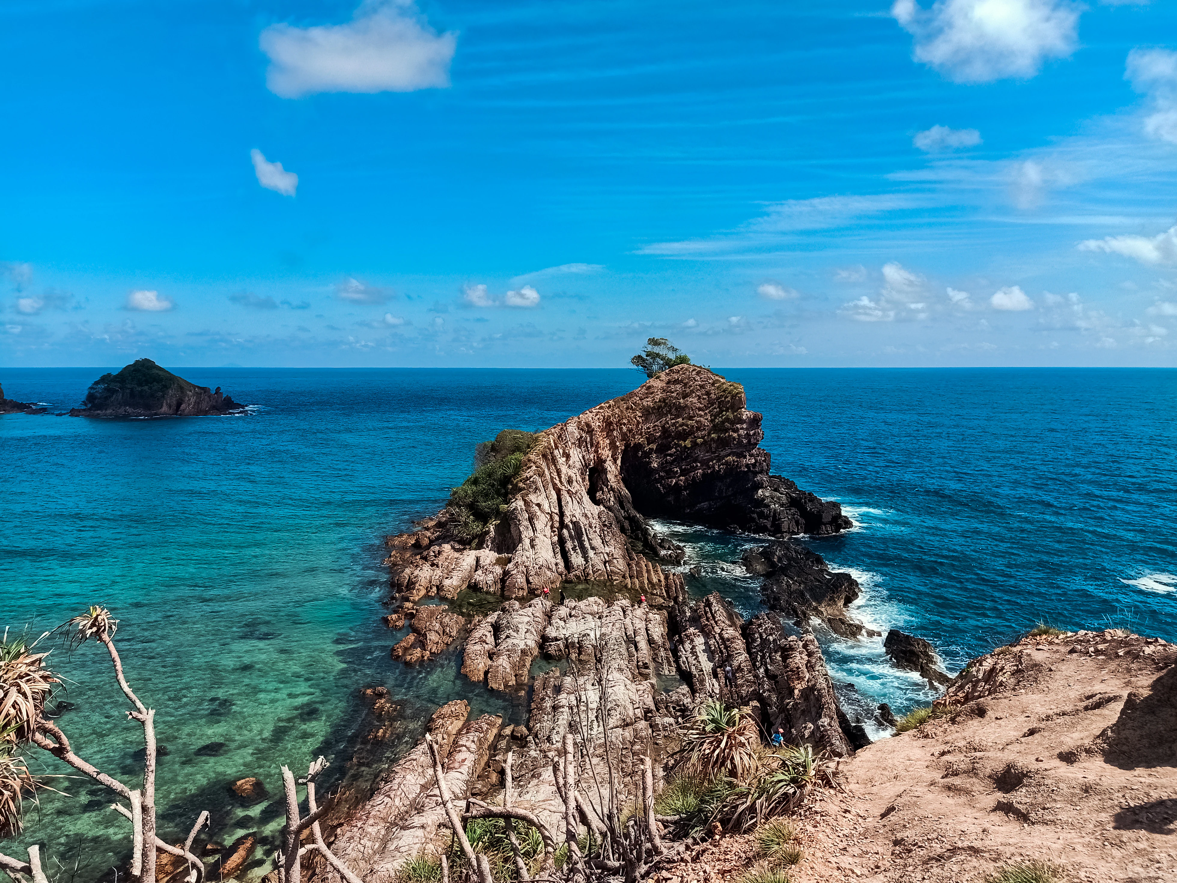
A high-angle view looking over a rugged, rocky ridge protruding into clear, turquoise sea water under a bright blue sky with light clouds.
A scenic view of the rocky coastline and clear blue waters from the summit of Bukit Singa on Kapas Island.

Kapas Island history and protected-area timeline

Kapas Island has historical references going back to the mid-nineteenth century. The Malay-language historical record notes that the island was mentioned by Abdullah Abdul Kadir Munshi around 1851 to 1852 in an account describing pirate activity along the Terengganu coast. In his narrative, small boats from Kuantan reported pirate vessels stationed at Tanjung Tujuh, Pulau Kapas, and Pulau Redang, with some boats captured and others escaping, providing a small but vivid window into the island's role in regional maritime history of that era.

In more recent decades, the island's identity has shifted toward tourism and marine research rather than its historical position in trading or seafaring routes. The development of ferry access from Marang, combined with the growth of small private resorts on the island, has made Kapas Island a regular destination on Terengganu's coastal tourism circuit. Its scientific profile has grown in parallel, particularly through sustained research into the unusual Amphidromus snail populations on the island.

Kapas Island landscape and geographic character

The landscape of Kapas Island is defined by the contrast between its forested interior and its white sand coastal perimeter. The interior retains a cover of tropical jungle, creating a green backdrop to the beaches that ring much of the island. From elevated vantage points such as Bukit Singa, visitors can look across the canopy and out toward the sea, taking in both the dense vegetation and the surrounding water in a single view.

The coastline itself is what most immediately identifies the island. Fine white sand lines the beaches, the source of the island's cotton-inspired name, and the surrounding sea is generally calm and clear near shore. The neighboring Gemia Island adds a smaller, rocky companion to the north, rounding out a small two-island archipelago that feels visually contained yet varied.

Coral reef formations fringe parts of the island in shallow water, blending into sand and rocky seabed further out. Shipwrecks in the surrounding waters contribute additional vertical structure beneath the surface. The overall landscape impression is one of a small, lush tropical island enclosed by clear tropical sea, with a scale and visual cohesion that make it easily readable as a single geographic unit.

Kapas Island ecosystems, habitats, and plant life

Kapas Island's natural environment is shaped by the meeting of tropical rainforest and tropical marine ecosystems within a very small geographic footprint. The island's interior jungle represents a fragment of the broader coastal rainforest cover once more widespread along Terengganu, while the surrounding waters host coral reefs and associated reeflife that give the island its marine character.

The reef environment around Kapas supports a variety of fish species, including some reported as uncommon elsewhere along this stretch of coast. The combination of clear water and reef structure has made the surrounding waters biologically productive, which in turn supports both reef-associated species and the larger marine food web in the area. The artificial reef effect of nearby shipwrecks adds another layer of habitat variability within the same waters.

On land, the tropical jungle cover provides habitat continuity across the interior, even at the small scale of the island. While the island is too compact to support large terrestrial mammal populations, the forest structure plays an important role in stabilizing soils, retaining freshwater, and maintaining the green character that frames the island's beaches.

Kapas Island wildlife and species highlights

The wildlife profile of Kapas Island is dominated by marine rather than terrestrial species, reflecting the island's small land area and its rich surrounding sea. Reef fish are the most frequently encountered animals in the waters around Kapas, with several species noted as uncommon elsewhere in the region. Snorkelers and divers regularly report a varied fish population close to shore, supported by the coral reef structures and the additional habitat complexity introduced by submerged wrecks nearby.

The island has gained particular scientific attention because of its Amphidromus snail populations. These snails are unusual among gastropods in that individual animals may coil either clockwise or anticlockwise, breaking the near-universal right-handed coiling pattern found across most snails. Kapas Island serves as the main research location for this group, and ongoing fieldwork there continues to shape scientific understanding of these snails' biology and distribution.

Other wildlife interest around the island includes the broader reef-associated fauna typical of South China Sea fringing reef systems. Because the island is small and heavily visited, terrestrial wildlife observation tends to be limited, but the marine life remains the headline wildlife experience for most people who encounter Kapas Island.

Kapas Island conservation status and protection priorities

Kapas Island's conservation significance lies in its unusual protection model and in the ecological value of the marine environment surrounding it. Unlike the majority of Malaysian islands that have been formally gazetted as marine parks under the Department of Fisheries, Kapas Island operates under a zoning arrangement that extends 1 nautical mile from shore at lowest tide. This makes it a distinct case within the country's marine conservation framework and gives it a different management identity from peers such as the offshore marine park islands.

The surrounding waters host coral reefs that form the backbone of the island's marine ecosystem. Protecting these reefs is essential not only for biodiversity but also for sustaining the reef fish populations, the snorkeling and diving economy, and the natural shoreline protection they provide. The presence of submerged wrecks adds further habitat, and managing these alongside the natural reefs is part of the broader conservation picture.

The island also has research-driven conservation relevance. The ongoing study of Amphidromus snails on Kapas has helped establish the island as an important scientific reference location, and the long-term presence of researchers contributes to a baseline of biological knowledge that supports future conservation decisions in the region.

Kapas Island cultural meaning and human context

Kapas Island carries a small but distinct cultural footprint tied to its name and its historical references. The Malay name "Pulau Kapas" reflects both the visual impression of its beaches and the cotton plant tradition associated with the island, in which the white fluff of the cotton flower could be used to make cloth. This dual naming layer connects the island to traditional material culture as much as to landscape description.

Nineteenth-century references to Pulau Kapas appear in the writings of Abdullah Abdul Kadir Munshi, placing the island within the documented maritime history of the Terengganu coast. In those accounts, the island is described in the context of regional seafaring life and the risks of piracy along the coast, a perspective that contrasts sharply with the island's modern image as a tourism and research destination.

Today, the cultural context of Kapas Island is largely shaped by small-scale coastal tourism. Several private resorts operate on the island, and visitor movement is mediated through ferry services from the nearby Marang jetty, situating the island within a familiar pattern of Malaysian coastal recreation culture.

Top sights and standout views in Kapas Island

Kapas Island's standout qualities are the clarity of its surrounding water, the quality of its white sand beaches, and the accessibility of its reef and wreck environments. These features collectively support a marine experience that has kept the island relevant within Terengganu's tourism offerings over time.

A second distinctive highlight is the island's scientific value as the principal research location for Amphidromus snails, an unusual feature that adds a layer of academic identity most visitor destinations do not have. Combined with the atypical 1 nautical mile zoning protection status, Kapas Island offers a combination of recreational, scientific, and conservation interest that sets it apart from neighboring islands on the Malaysian east coast.

Best time to visit Kapas Island

The character of Kapas Island shifts with the broader monsoon patterns that affect Malaysia's east coast. During the drier months, when seas tend to be calmer and visibility in coastal waters is generally better, conditions for snorkeling, diving, and beach activities around the island are typically more favorable. Marine life viewing and reef observation tend to align with these calmer sea conditions.

During the more rain-affected monsoon period, the surrounding sea can become rougher and less clear, and access to the island via ferry from Marang may be subject to weather conditions. Even outside peak conditions, the lush tropical vegetation character of the island remains a constant visual feature, while the marine experience is more strongly affected by season. As a general orientation, planning around the calmer seasonal window tends to produce a more rewarding visit focused on the island's marine features.
Monthly climate preview

Long-term representative monthly temperature and precipitation patterns for Kapas Island

Kapas Island Climate Normals, Average Temperature and Precipitation

Historical NASA Power data for Kapas Island reveals consistent monthly temperature ranges alongside distinct variations in average daily precipitation across the year. Examining the full twelve-month climate profile provides deeper context for long-term environmental patterns at this Terengganu protected location.
Annual mean26 °C
25 °C27 °C
Jan25°
Feb25°
Mar26°
Apr27°
May27°
Jun27°
Jul26°
Aug26°
Sep26°
Oct26°
Nov26°
Dec25°
Warmest month
May

27.3 °C

Coolest month
January

24.6 °C

Wettest month
December

19.5 mm/day

Driest month
February

3.9 mm/day

Park location guide

Geography guide, regional context, and park location map for Kapas Island

Kapas Island park geography, regions, and map view in Malaysia

Understand where Kapas Island sits in Malaysia through a broader geographic reading of the surrounding landscape, nearby location context, and its mapped position within the national park landscape.

How Kapas Island fits into Malaysia

Malaysia is a federal constitutional monarchy located in Southeast Asia. The country consists of 13 states and three federal territories, divided by the South China Sea into Peninsular Malaysia on the Indochinese Peninsula and East Malaysia on the island of Borneo. With a population of over 34 million, it achieved independence from Britain in 1957 and became a modern federation in 1963. The country is recognized for its multicultural population, tropical climate, and significant economic role in the region.

Wider geography shaping Kapas Island in Malaysia

Malaysia occupies a strategic position in Southeast Asia, split by the South China Sea into two distinct regions. Peninsular Malaysia lies on the Indochinese Peninsula, sharing a land border with Thailand to the north and maritime borders with Singapore, Vietnam, and Indonesia. East Malaysia occupies the northern portion of Borneo, sharing land borders with Brunei and Indonesia, and maritime borders with the Philippines and Vietnam. The country's terrain includes coastal plains, mountain ranges such as the Titiwangsa in the peninsula, and extensive tropical rainforests.

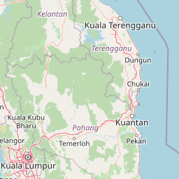
Map view of Kapas Island

Use this park location map to pinpoint Kapas Island in Malaysia, understand its exact geographic position, and read its mapped placement within the surrounding landscape more clearly.

Pigeon | © OpenStreetMap contributors

Location context for Kapas Island

Terengganu

Explore detailed visual records of tropical jungle interiors, white sand coastlines, and coral reef formations.

Kapas Island Photos and Landscape Scenery: Visualizing Protected Marine Environments

Visual documentation captures the striking contrast between dense rainforest canopies and clear marine shallows across the protected coastal zone. Examining these detailed landscape photographs provides a comprehensive understanding of the island terrain and surrounding aquatic habitats.

A high-angle view looking over a rugged, rocky ridge protruding into clear, turquoise sea water under a bright blue sky with light clouds.

A tropical beach with light sand and clear water, bordered by a dense green forest and a row of palm trees leaning toward the shore under an overcast sky.

Park atlas

Compare regional marine geography and coastal conservation zones across Malaysia

Explore Parks Near Kapas Island and Surrounding Protected Coastal Landscapes

Browse nearby national parks and protected areas to compare coastal marine geography with Kapas Island. Extending the regional search reveals related protected landscapes and adjacent island ecosystems across the east coast.
Protected areaTerengganu
About 66 km away#1 closest

Southeast

Tenggol Island: A Geographic Overview of Terengganu's Protected Tropical Marine Landscape

Mapping reefs, forest interior, and regional maritime terrain

Tenggol Island stands as a distinct protected area off the coast of Terengganu, defined by its sharp 272-meter forested peak and complex underwater topography. This overview provides data on its coastal bays, rocky points, and fringing reef zones, offering a clear understanding of the island's unique position within the East Coast of Peninsular Malaysia's marine geography.

Area
2.62 km²
Relief
Upland
Climate
Tropical
Access
Moderate access
A watercolor painting of a tropical island coastline with palm trees, green vegetation, rocks in the foreground, and distant purple mountains under a soft light.
Marine protected areaTerengganu
About 67 km away#2 closest

Northwest

Redang Island Marine Protected Area: Coastal Terrain and Reef Ecosystems

Geographic atlas of the Terengganu island archipelago

Redang Island is a prominent marine protected area within the South China Sea, characterized by its forested interior, sheltered bays like Teluk Dalam, and expansive coral reef systems. As a key ecological site off the Terengganu coast, the island provides a unique study in island geography and marine conservation, offering detailed insights into the protected reef environments and coastal morphology of Peninsular Malaysia.

Area
24.2 km²
Relief
Upland
Climate
Tropical
Access
Moderate access
A watercolor painting showing a stylized, panoramic view of layered purple and pink mountains in the background with soft green forests and grassy plains in the foreground.
Marine protected areaTerengganu
About 75 km away#3 closest

Northwest

Lang Tengah Island Marine Protected Area: Geography, Reefs, and Island Terrain

A tranquil protected landscape in the Terengganu archipelago

Lang Tengah Island represents a significant marine protected area defined by its dense forested interior and surrounding coral reef ecosystems. Located within the Terengganu marine region, the island offers a unique study of protected coastal geography, seasonal turtle nesting grounds, and undisturbed tropical marine environments separated from more developed nearby archipelagos.

Area
1.3 km²
Relief
Lowland
Climate
Tropical
Access
Moderate access
A watercolor illustration of a wooden pier extending into calm wetland waters, with lush green shorelines and trees on both sides.
State or regional parkTerengganu
About 79 km away#4 closest

Northwest

Setiu Wetlands State Park: Geography and Protected Area Atlas of Terengganu

Coastal lagoons, mangrove forests, and riverine ecosystems

Encompassing the largest natural wetland on Malaysia's east coast, Setiu Wetlands State Park serves as a critical protected landscape where sea, sand, and forest meet. This atlas entry details the park's 23,000 hectare expanse, highlighting the complex hydrological network of lagoons and river basins that support diverse habitats, including peat swamps and seagrass beds.

Area
230 km²
Established
2018
Relief
Lowland
Climate
Tropical
An illustrative style image of a dramatic mountain valley featuring cliffs, two waterfalls, and a forested foreground at sunset.
Marine protected areaTerengganu
About 97 km away#5 closest

Northwest

Perhentian Islands Marine Protected Area: Terengganu Coastal and Archipelago Geography

Mapped marine boundaries and tropical island terrain

An immersive look at the Perhentian Islands, a protected nine-island archipelago in the South China Sea. Analyze the distinct marine geography, from fringing coral reefs and shallow reef flats to the forested inland hills of Perhentian Besar and Perhentian Kecil. This overview provides spatial context for one of Malaysia's most recognizable marine environments, emphasizing the protected status of its surrounding waters and reef habitats.

Area
15.955 km²
Established
1994
Relief
Lowland
Climate
Tropical
National parkPahang
About 106 km away#6 closest

Southwest

Taman Negara National Park: Pahang Protected Area with Mapped Boundaries for Geographic Discovery

Explore the unique landscape context within Pahang, Malaysia.

Delve into Taman Negara National Park, a significant protected area situated in Pahang, Malaysia. This detailed view highlights the park's mapped boundaries and its contribution to the regional geography. Understand the protected landscape and its place within the natural terrain of Peninsular Malaysia, essential for atlas-based geographic exploration.

Area
4,343 km²
Established
1938
IUCN
II
Relief
Mixed relief
A soft watercolor painting of a serene lake scene with rolling hills in the background, green vegetation along the banks, and pale pink blooms, likely lotus flowers, in the water.
Biosphere reservePahang
About 201 km away#7 closest

South

Chini Lake Biosphere Reserve: Protected Freshwater Geography in Pahang, Malaysia

Examining the interconnected lake basins and tropical wetland terrain

Chini Lake is an essential protected freshwater system in Pahang, Malaysia, comprising a series of twelve connected lake basins and tropical forest margins. This landscape is a recognized UNESCO Biosphere Reserve, characterized by seasonal lotus blooms, peat-influenced wetlands, and deep cultural connections to the indigenous Jakun communities. Discover the geography and environmental context of this river-fed ecosystem.

Area
50.85 km²
Established
2019
Relief
Lowland
Climate
Tropical
Wildlife reservePahang
About 206 km away#8 closest

Southwest

Tengku Hassanal Wildlife Reserve: Protected Forest and Mountain Geography in Pahang

Mapping a vast lowland dipterocarp forest sanctuary.

Spanning over 600 square kilometers, Tengku Hassanal Wildlife Reserve stands as a core protected area within Pahang. Its landscape includes riverine valleys and the steep montane terrain of the Benom Complex, supporting unique biodiversity and active wildlife conservation. This overview traces the park's geographic footprint and its role as an ecological corridor within the broader Titiwangsa mountain system.

Area
605.52 km²
Established
1923
Relief
Mountain
Climate
Tropical

Common questions about visiting, size, designation, and location context for Kapas Island

Kapas Island FAQs for park facts, access, geography, and protected area context

Find quick answers about Kapas Island, including protected-area facts, park geography, trail and visitor context, and how the park fits into its surrounding country and regional landscape.
MoriAtlas Explorer

Continue Your Protected Areas Search Across the Global Atlas

Deepen your exploration by continuing the structured search for national parks and protected areas worldwide. Utilize the comprehensive filtering capabilities to compare different conservation landscapes and refine your understanding of global park geography. Discover more about the distribution and characteristics of protected natural areas.

Global natural geography