
Mori Atlas logo
Nature reserveKernzone Ommelstal

A vital stream valley habitat and wetland refugium within the Rommerskirchener Lössplatte.

Kernzone Ommelstal Protected Landscape: Mapping the Nature Reserve in North Rhine-Westphalia

(Naturschutzgebiet Kernzone Ommelstal)

Kernzone Ommelstal represents a compact nature reserve in western Germany where the Fliestedener Bach has carved a distinct shallow valley into the open agricultural plains. This protected area provides a diverse mosaic of ponds, moist meadows, and woodland patches that serve as an essential ecological refuge. Beyond its habitat value, the reserve safeguards local cultural history, integrating the historic Jewish cemetery of Fliesteden into its protected geographic boundaries.

nature reservewetland valleystream valleywoodlandpondsagricultural plain
A flat-design, vector-style illustration showing a tall waterfall cascading down a cliff into a mountain lake, framed by stylized trees in the foreground.

Kernzone Ommelstal

Nature reserve

Park overview

Structured park overview, official facts, and landscape profile for Kernzone Ommelstal

Kernzone Ommelstal park facts, protected area profile, and essential visitor context

Review the core facts for Kernzone Ommelstal, including designation, size, terrain, visitor scale, habitats, and operating context in one park-focused overview.

About Kernzone Ommelstal

Kernzone Ommelstal is a small but ecologically focused nature reserve in the western German Rhineland, situated on the open agricultural plain between the towns of Bergheim and Pulheim. Although its surface area is modest at just over fourteen hectares, the reserve plays a disproportionate role in local biodiversity conservation because it preserves a habitat mosaic that has largely disappeared from the surrounding farmland.

The valley itself was formed over time by the Fliestedener Bach, a small watercourse that eroded a shallow depression into the loess-rich ground of the Rommerskirchener Lössplatte. Within this valley, the protected area combines woodland patches, scrub, ponds, and moist to alternating-moist zones that support a more varied ecological community than the uniform surrounding fields. The reserve's designation in 2017 was specifically intended to halt further degradation of these biotope structures and to encourage the stream and its associated waters to develop into a near-natural habitat system.

The site sits northeast of the Bergheim district of Fliesteden, framed by the village to one side and the Bundesstraße 59 federal road on the other. This positioning makes it both a green oasis in an agricultural matrix and a visible local landmark for residents and travelers navigating the plain. From a conservation standpoint, it functions as a Habitat/Species Management Area under the IUCN system (Category IV), recognizing that the goal is not strict wilderness but active stewardship of defined habitat types.

The protected area is administered as part of Landscape Plan 7, the Rommerskirchener Lössplatte plan, and is registered under the official identifier BM-047 in the North Rhine-Westphalian nature conservation information system. It is also recorded internationally through the World Database on Protected Areas under WDPA-ID 555638614, documenting its place within the broader German network of formally recognized nature reserves.

Beyond its ecological role, the reserve also carries regional cultural meaning. The historic Jewish cemetery of Fliesteden lies within its boundaries, connecting the natural landscape to the longer human history of the area. The combination of a protected wetland-wet woodland complex and a preserved site of community memory gives Kernzone Ommelstal a layered identity that goes well beyond its modest size.

Quick facts and research context for Kernzone Ommelstal

Kernzone Ommelstal is a designated nature reserve (Naturschutzgebiet) in the Rhein-Erft-Kreis district of North Rhine-Westphalia, Germany. It lies on the loess plateau landscape known as the Rommerskirchener Lössplatte, northeast of the Bergheim district of Fliesteden, between the village and the Bundesstraße 59 federal road.

The reserve was formally designated in 2017 and is managed under the regional landscape plan, Landscape Plan 7: Rommerskirchener Lössplatte. It carries the official German identifier BM-047 and is recorded in the World Database on Protected Areas under WDPA-ID 555638614. It is classified as an IUCN Category IV habitat and species management area, reflecting its focus on active protection and development of specific biotope structures rather than purely wilderness preservation.

Protection and recognition

Examine documented protection records and international registry data for Kernzone Ommelstal

Kernzone Ommelstal Protection Status and Designated Area Records

Kernzone Ommelstal conservation metrics consolidate official protection status, geographic designation history, and verified database records. Regular updates ensure reliable tracking of protected area boundaries, management frameworks, and international registry identifiers.

Protection details

WDPA ID
555638614
Park context

Deeper park guide and search-rich context for Kernzone Ommelstal

Kernzone Ommelstal history, landscape, wildlife, and travel context

Explore Kernzone Ommelstal through its history, landscape character, ecosystems, wildlife, conservation priorities, cultural context, and seasonal travel timing in a structured park guide built for atlas discovery and search intent.

Why Kernzone Ommelstal stands out

Kernzone Ommelstal is best known for being a locally important refugium of wet woodland, ponds, and moist meadow habitats within an otherwise intensively farmed loess landscape. The valley was shaped by the Fliestedener Bach and once drained through open agricultural land; its protection now allows shrubs, woodland, open water, and periodically waterlogged ground to coexist in a compact area. The reserve is also notable as a single integrated conservation unit that bundles habitat protection with elements of regional cultural heritage, since the historic Jewish cemetery of Fliesteden lies within its boundaries. This combination of stream-valley wetland ecology and a piece of local community history gives the small reserve an outsized identity within the network of protected sites in the Rhein-Erft-Kreis.

A honeybee hovering near cluster of small white flowers on a green leafy branch.
A bee in flight near white flowering shrubs in Kernzone Ommelstal.

Kernzone Ommelstal history and protected-area timeline

The formal protection history of Kernzone Ommelstal is recent, beginning with its designation as a nature reserve in 2017. Before that point, the Ommelstal functioned largely as an agricultural side valley drained by the Fliestedener Bach, with its varied habitats shaped more by gradual erosion and water dynamics than by deliberate conservation management.

The decision to designate the area as a Naturschutzgebiet was taken within the framework of the regional landscape planning process for the Rommerskirchener Lössplatte, specifically under Landscape Plan 7. This plan groups the reserve together with other protected sites in the Rhein-Erft-Kreis that share the loess-plateau setting and the challenge of preserving habitat diversity amid intensive agriculture.

Since its 2017 designation, the reserve has been managed to halt the ongoing loss of biotope structures within the valley and to support the gradual conversion of the stream corridor into a near-natural habitat. The presence of a Jewish cemetery within the protected area boundary also imposes an additional layer of stewardship, linking ecological protection with the preservation of a site of regional cultural and historical significance.

Kernzone Ommelstal landscape and geographic character

The landscape of Kernzone Ommelstal is defined by a shallow valley cut into the gently rolling loess plain characteristic of the Rommerskirchener Lössplatte. This valley runs between the Bergheim district of Fliesteden and the corridor of the Bundesstraße 59 federal road, providing a visible natural incision in an otherwise open and largely agricultural setting.

The valley's morphology reflects the long-term erosional work of the Fliestedener Bach, which over time carved and shaped the low ground that the reserve now protects. Within this shallow depression, the terrain shifts between small ponds and still water bodies, slightly higher woodland patches, scrubby edges, and seasonally moist or waterlogged strips that produce an unusually varied microtopography for so small an area.

Surrounding the reserve, the broader landscape is dominated by farmland stretching across the fertile loess soils. This agricultural backdrop makes the green, structured valley of Kernzone Ommelstal stand out sharply as a localized refuge of irregular, semi-natural terrain in a sea of cultivated fields.
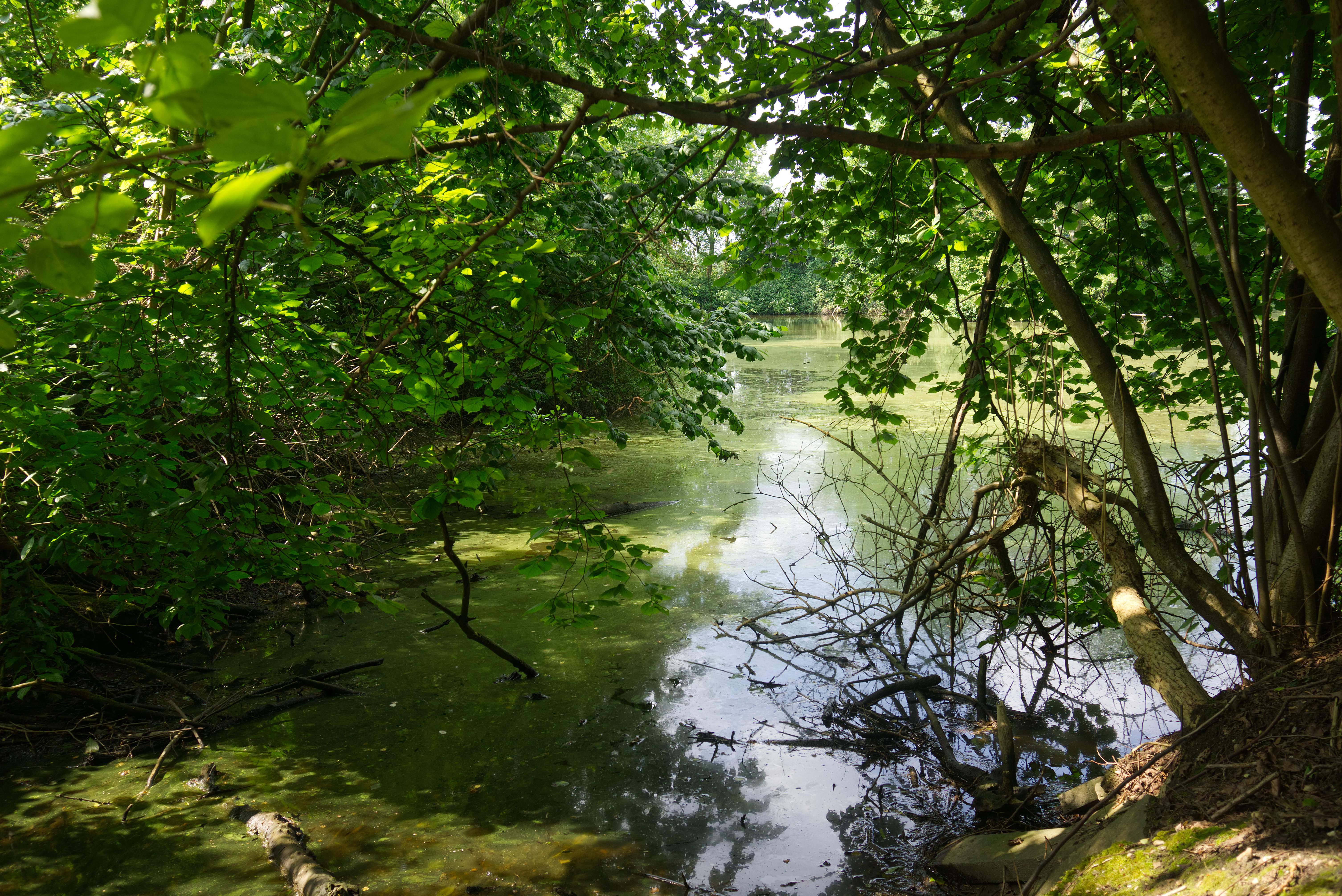
A small, still pond framed by lush green trees and shrubs, with overhanging branches reflecting in the water.
A small pond surrounded by dense vegetation in the Kernzone Ommelstal nature reserve.

Kernzone Ommelstal ecosystems, habitats, and plant life

The ecological character of Kernzone Ommelstal centers on the combination of woodland, scrub, open water, and moist to alternating-moist habitats packed into a small valley. This habitat mosaic supports a community of plants and animals that would struggle to persist in the intensively farmed loess plain that surrounds the reserve.

The presence of stream, pond, and periodically flooded ground gives the site a particular emphasis on wet and moist ecological conditions. These zones provide breeding, foraging, and sheltering habitat for a range of species adapted to water-rich environments, including waterbirds that take advantage of the small open water bodies within the reserve.

The combination of dry woodland patches and humid microhabitats in close proximity creates transitional edge zones that are ecologically valuable. Such transitions tend to host high species diversity in small areas, and they form the core ecological justification for protecting the Ommelstal as a coherent whole rather than as separate habitat fragments.
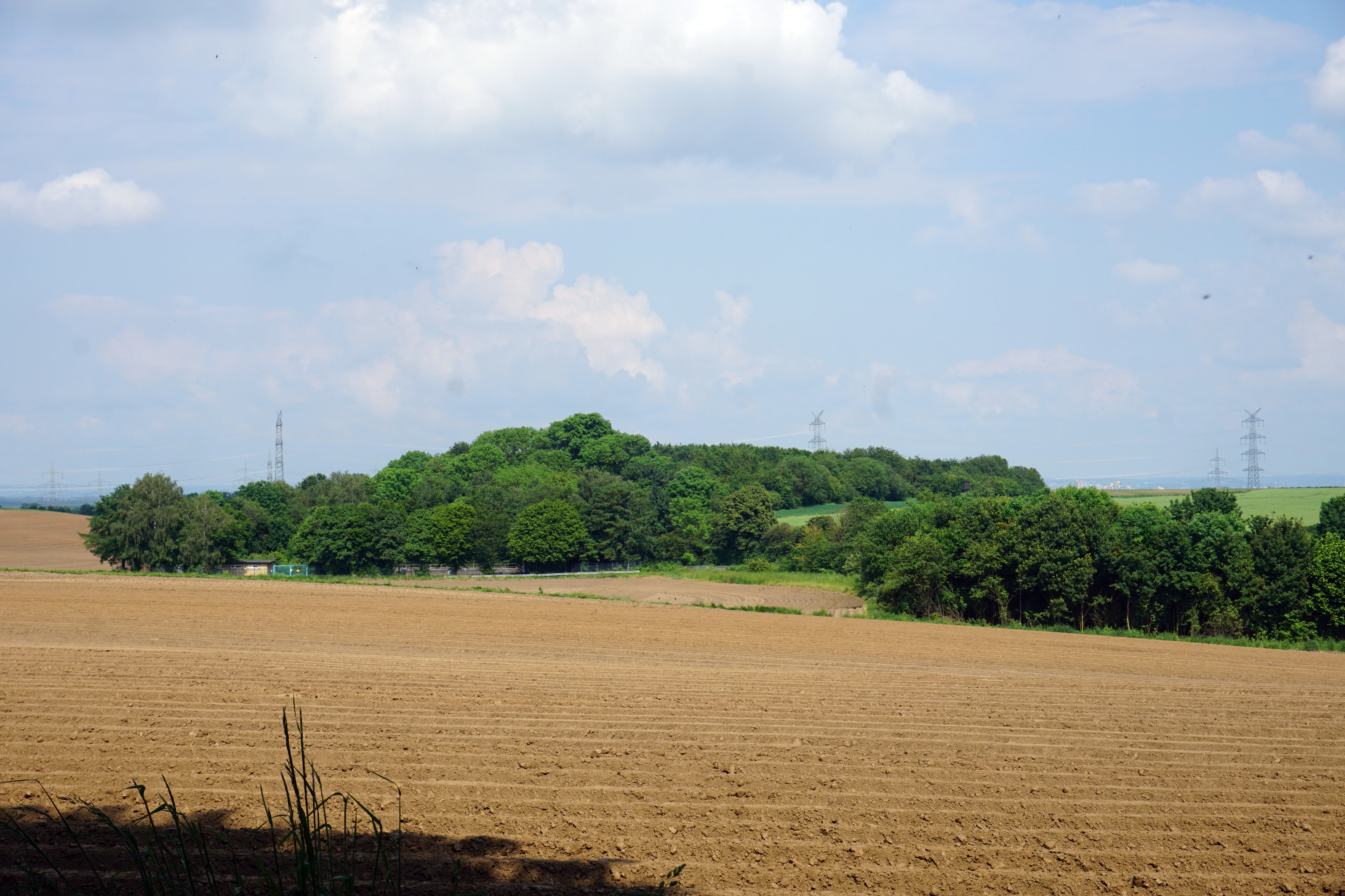
A wide shot showing a dense green forest patch in the middle ground surrounded by large, tilled agricultural fields under a partially cloudy blue sky.
View of the Kernzone Ommelstal nature reserve, showing the protected wooded area surrounded by agricultural fields.

Kernzone Ommelstal wildlife and species highlights

Kernzone Ommelstal supports a notably varied wildlife community for its size, particularly because the reserve combines open water, woodland, scrub, and moist meadow habitats within a compact area. Waterbirds make regular use of the small ponds and stream sections, and the reserve has documented use by cormorants, which use the open water as a foraging site.

Insect life is also visibly prominent. The mix of flowering wetland vegetation, scrub, and woodland edges provides habitat for wild bees and other pollinators, and the reserve has been noted as a place where these groups are encountered throughout the warm season. The combination of standing and flowing water, damp soils, and sheltered vegetation also creates habitat conditions favorable for amphibians, dragonflies, and other wetland-associated fauna.

While the reserve is too small to host populations of large mammals, its structure and connectivity within the surrounding agricultural matrix make it an important local stepping stone for smaller wildlife species, particularly those tied to wet woodland and stream corridors.
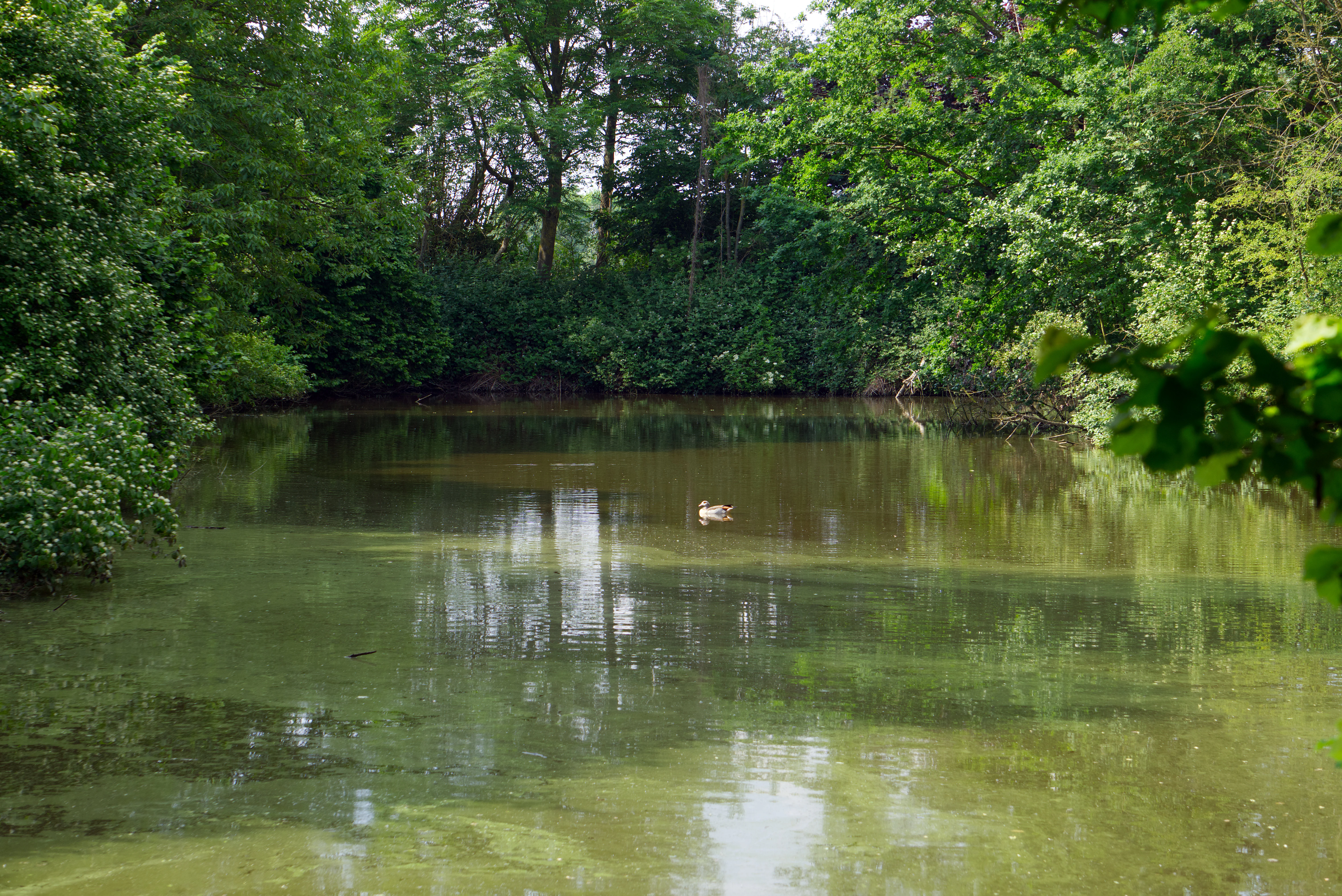
A small pond with green, algae-covered surface water reflects the surrounding dense green forest; a single duck swims in the center.
A tranquil pond surrounded by dense deciduous trees in Kernzone Ommelstal.

Kernzone Ommelstal conservation status and protection priorities

The conservation significance of Kernzone Ommelstal lies in its role as a formally protected island of habitat diversity within one of the more intensively used agricultural areas of the Rhineland. By preserving a valley woodland, pond, and moist-ground mosaic that would otherwise be vulnerable to drainage, ploughing, and land-use intensification, the reserve safeguards ecological features that have largely been lost from the surrounding loess plain.

The reserve is classified as an IUCN Category IV Habitat/Species Management Area, signaling that its management aims at active stewardship of particular habitat types rather than at leaving the area to purely unmanaged processes. The objective is to maintain, and where possible enhance, existing biotope structures while guiding the stream and pond system toward a more natural condition.

By being integrated into the broader Landscape Plan 7 for the Rommerskirchener Lössplatte, Kernzone Ommelstal also contributes to a wider regional conservation strategy. The plan coordinates protection across multiple reserves in the Rhein-Erft-Kreis, and the Ommelstal serves as one of the smaller but functionally important wet-habitat units within this network alongside larger forest reserves, heath sites, and gravel-pit lakes.

Kernzone Ommelstal cultural meaning and human context

Within the boundaries of Kernzone Ommelstal lies the Jüdischer Friedhof Fliesteden, the historic Jewish cemetery of the Fliesteden area. This site represents a tangible link to the longer human history of the region, when small rural communities such as Fliesteden maintained their own burial grounds for their Jewish populations well before the twentieth century.

The inclusion of the cemetery within the nature reserve reflects a broader German practice of grouping cultural heritage features with ecologically valuable sites in the same protected area. This arrangement imposes a duty of care for both the natural habitats and the historic site, and it links the ecological identity of the Ommelstal with the memory of the surrounding community.

Seen in this context, the reserve is not just a piece of wet woodland and pond; it is also a quiet memorial landscape, where the natural environment and the cultural history of the plain meet within a single unified protected boundary.

Top sights and standout views in Kernzone Ommelstal

The standout feature of Kernzone Ommelstal is the tight convergence, within just over 14 hectares, of a stream valley, woodland patches, ponds, and moist to alternating-moist ground that would be highly unusual to find in such a small area within the surrounding arable plain.

Equally distinctive is the layering of natural and cultural values: the same protected area that conserves habitat for cormorants, bees, and pond life also contains the Jewish cemetery of Fliesteden, making the reserve a place where local ecological and historical identity intersect.

Finally, its classification as an IUCN Category IV Habitat/Species Management Area under the regional Rommerskirchener Lössplatte landscape plan gives Kernzone Ommelstal a clear, active conservation role rather than a passive one, distinguishing it from purely scenic or wilderness-style reserves.

Best time to visit Kernzone Ommelstal

The most rewarding period to experience Kernzone Ommelstal is during the warmer months of late spring and summer, when pond levels, flowering wetland vegetation, and insect activity are at their peak. During this window the reserve's mosaic of woodland, scrub, and water is most biologically expressive, and waterbirds, pollinators, and other fauna are easiest to observe along the edges of the ponds and stream.

In early spring, the moist ground and still leafless woodland can also be appealing because bird activity tends to be high and the valley's topography is easy to read against the bare surrounding fields. In autumn and winter, the agricultural backdrop dominates visually and the reserve appears quieter, with reduced insect and amphibian activity, though waterbirds may continue to make use of the open water.

Because the reserve is small and embedded in working farmland, it is best treated as a short, focused nature walk at any season rather than as a destination for extended touring.


Monthly climate preview

Long-term representative measurements of monthly temperature and precipitation patterns

Kernzone Ommelstal Climate Normals, Annual Temperature and Precipitation Rhythm

Kernzone Ommelstal records span measured monthly temperature variations and consistent precipitation rates derived from multi-year climatology data. Reviewing the complete twelve-month normals profile provides deeper analytical context for long-term regional weather patterns.
Annual mean10 °C
1 °C19 °C
Jan
Feb
Mar
Apr
May13°
Jun17°
Jul19°
Aug19°
Sep15°
Oct10°
Nov
Dec
Warmest month
July

19.2 °C

Coolest month
January

1.3 °C

Wettest month
December

2.6 mm/day

Driest month
April

1.6 mm/day

Park location guide

Geography guide, regional context, and park location map for Kernzone Ommelstal

Kernzone Ommelstal park geography, regions, and map view in Germany

Understand where Kernzone Ommelstal sits in Germany through a broader geographic reading of the surrounding landscape, nearby location context, and its mapped position within the national park landscape.

How Kernzone Ommelstal fits into Germany

Germany is a federal republic in Western and Central Europe with a population of over 83 million across sixteen constituent states. It is Europe's largest economy by nominal GDP and a major global exporter and importer. The capital is Berlin, and the country borders Denmark, Poland, Czech Republic, Austria, Switzerland, France, Luxembourg, Belgium, and the Netherlands.

Wider geography shaping Kernzone Ommelstal in Germany

Germany is located in Western and Central Europe, spanning 357,022 km². It borders Denmark to the north, Poland and the Czech Republic to the east, Austria and Switzerland to the south, and France, Luxembourg, Belgium, and the Netherlands to the west. The country has coastlines on the Baltic Sea and North Sea to the north, with the Alps located in the southern region.

Map view of Kernzone Ommelstal

Use this park location map to pinpoint Kernzone Ommelstal in Germany, understand its exact geographic position, and read its mapped placement within the surrounding landscape more clearly.

Pigeon | © OpenStreetMap contributors

Location context for Kernzone Ommelstal

Nordrhein-Westfalen

Visual reference for the stream valley, wet woodland habitats, and microtopography

Kernzone Ommelstal Landscape Photos and Protected Area Scenery

These curated Kernzone Ommelstal photos reveal the distinct terrain, shallow stream valleys, and mosaic of moist woodland habitats characterizing the reserve. Examining the visual protected area scenery helps visitors understand how natural wetlands contrast with the surrounding agricultural plain.

A honeybee hovering near cluster of small white flowers on a green leafy branch.

A cormorant standing on a bare branch extending above the surface of a pond, with its wings spread out to dry in a nature reserve.

A small, still pond framed by lush green trees and shrubs, with overhanging branches reflecting in the water.

A wide shot showing a dense green forest patch in the middle ground surrounded by large, tilled agricultural fields under a partially cloudy blue sky.

A small pond with green, algae-covered surface water reflects the surrounding dense green forest; a single duck swims in the center.

Park atlas

Compare regional stream valleys and wetland reserves across the agricultural plain

Exploring Parks Near Kernzone Ommelstal and Surrounding Protected Landscapes

Browsing other protected areas near Kernzone Ommelstal reveals connected ecological corridors and diverse regional wetland habitats. Comparing these nearby nature reserves provides deeper geographic context on the agricultural loess terrain of western Germany.
A horizontal watercolor painting depicting a gentle, hazy green landscape with rolling hills, a line of trees, and a foreground meadow.
Protected landscapeNorth Rhine-Westphalia
Mapped location lies within the park boundary#1 closest

South

Naturpark Rheinland: Geography and Protected Area Overview in North Rhine-Westphalia

A complex metropolitan nature park and lake district

Naturpark Rheinland represents a distinct convergence of reclaimed lignite mining landscapes, quiet lowland forests, and floodplain wetlands. Its mapped boundaries reveal a diverse terrain of ridges and river valleys that define the environmental character of the Cologne-Bonn metropolitan region.

Area
1,045 km²
Established
1959
Relief
Upland
Climate
Temperate
Nature reserveNorth Rhine-Westphalia
About 8.5 km away#2 closest

Northeast

Worringer Bruch Nature Reserve: A Relict Rhine Floodplain in North Rhine-Westphalia

Ancient oxbow meander and vital inner-city wetland landscape.

Worringer Bruch stands as one of the best-preserved, silted-up oxbow meanders along the Lower Rhine. Spanning roughly 164 hectares, this nature reserve integrates floodplain forests, traditional orchards, and marshy meadows into a cohesive wetland mosaic. Serving as a low-lying ecological refuge near Cologne, the area remains deeply connected to the groundwater dynamics of the historic Rhine river corridor.

Area
1.64 km²
Established
1991
Relief
Lowland
Climate
Temperate
Watercolor illustration of a peaceful lake with trees on a small island and flowering meadows in the foreground.
Nature reserveNordrhein-Westfalen
About 15 km away#3 closest

Northeast

Monheimer Baggersee Nature Reserve: Geographic Overview and Protected Landscape Mapping

Located within the Lower Rhine terrace of Nordrhein-Westfalen

Monheimer Baggersee represents a vital protected landscape shaped from a former gravel quarry. This reserve provides a comprehensive geographic look at mineral-substrate habitats, irregular lake shorelines, and specialized avian breeding grounds within the urbanized Mettmann district.

Area
0.712 km²
Established
1981
IUCN
IV
Relief
Lowland
Nature reserveLeverkusen
About 15 km away#4 closest

Northeast

Krapuhlsee Nature Reserve: Protected Wetland and Gravel Lake Geography in Leverkusen

Exploring post-industrial habitat mosaics and conservation terrain

Krapuhlsee is a protected nature reserve in Leverkusen, North Rhine-Westphalia, known for its unique concentration of post-mining gravel lakes and nutrient-poor grassland habitats. Managed to support rare wild bee populations and ground-nesting birds, the reserve acts as a critical stepping-stone for ecological connectivity across the heavily industrialized Rhine corridor.

Area
0.082 km²
Established
1986
IUCN
IV
Relief
Lowland
A watercolor illustration showing a landscape with a calm lake surrounded by greenery, small trees, and gently rolling hills in the background.
Nature reserveNordrhein-Westfalen
About 15 km away#5 closest

Southeast

Hürther Waldsee Nature Reserve: Mapped Protected Geography and Reclaimed Mining Landscape

Ecological refuge on the Ville lake plateau of Germany

Examine the boundaries and natural features of Hürther Waldsee, a significant nature reserve in the Nordrhein-Westfalen region. This ten-hectare reclaimed mining lake offers a detailed map of post-industrial ecological recovery, featuring engineered islands, reed beds, and young beech and alder woodlands that define its protected status.

Area
0.106 km²
Established
1988
Relief
Lowland
Access
Moderate access
Nature reserveNordrhein-Westfalen
About 17 km away#6 closest

Northeast

Wupperinsel Nature Reserve: Mapped Protected Landscapes in Nordrhein-Westfalen

Riparian woodland, floodplain islands, and meadow habitats.

Discover the geographic role of Wupperinsel as a designated nature reserve within the Wupper River corridor. This site features a rare Glatthafer meadow, mature poplar lines, and mixed-woodland groves that provide essential habitat connectivity. Analyze the protected island boundaries and the layered floodplain terrain that characterize this significant ecological fragment in urban Germany.

Area
0.054 km²
Established
1987
IUCN
IV
Watercolor painting of a pastoral landscape featuring a winding river, green fields, and clusters of trees, rendered in a soft, impressionistic style on a white background.
Nature reserveNordrhein-Westfalen
About 19 km away#7 closest

Northeast

Southerberg Nature Reserve: Protected Woodland and Wetland Mosaic in Nordrhein-Westfalen

A rare habitat bridge on the Bergische Sand terrace.

Southerberg serves as a crucial nature reserve in Leverkusen, Nordrhein-Westfalen, balancing wet birch-oak forests with reedbeds and meadows. This compact protected area functions as a key ecological connector between larger regional habitats, showcasing a refined topographic transition from valley basin to sandy slope.

Area
0.149 km²
Established
1987
IUCN
IV
Relief
Lowland
A minimalist watercolor painting showing stylized green trees and rolling hills against a pale, soft-colored background.
Nature reserveNordrhein-Westfalen
About 19 km away#8 closest

Northeast

Schlosspark Benrath Nature Reserve in Nordrhein-Westfalen: A Geographic and Landscape Atlas

Examining historic baroque design and floodplain woodland ecosystems.

Schlosspark Benrath encompasses a vital protected area where rococo architectural layout meets ecologically diverse floodplain forest. Known for its star-shaped linden avenues, ancient yew understory, and significant deadwood habitats, this reserve functions as a crucial green corridor within the lower Rhine terrace, supporting a wide range of bird species and rare beetles.

Area
0.443 km²
Established
2016
IUCN
IV
Relief
Lowland

Common questions about visiting, size, designation, and location context for Kernzone Ommelstal

Kernzone Ommelstal FAQs for park facts, access, geography, and protected area context

Find quick answers about Kernzone Ommelstal, including protected-area facts, park geography, trail and visitor context, and how the park fits into its surrounding country and regional landscape.
MoriAtlas Explorer

Continue Your Protected Areas Search Across the Global Atlas

Deepen your exploration by continuing the structured search for national parks and protected areas worldwide. Utilize the comprehensive filtering capabilities to compare different conservation landscapes and refine your understanding of global park geography. Discover more about the distribution and characteristics of protected natural areas.

Global natural geography