
Mori Atlas logo
Nature reserveWorringer Bruch

A preserved 8,000-year-old river meander serving as a vital sanctuary for biodiversity.

Worringer Bruch Nature Reserve: Exploring a Relict Rhine Wetland and Floodplain Landscape

(Naturschutzgebiet Worringer Bruch (K-009))

Worringer Bruch represents a significant relict landscape in North Rhine-Westphalia, functioning as a silted-up oxbow meander of the Lower Rhine. As the lowest natural point within Cologne, this nature reserve serves as a diverse mosaic of floodplain forests, wet meadows, and reed marshes. The site offers profound insight into historical river hydrology and provides a crucial, undisturbed habitat for wetland-dependent species in one of Europe's most densely populated regions.

floodplainwetlandRhine meandernature reservelowlandlower Rhine
A stylized vector-style illustration of a marshy valley featuring a winding river, dead trees, coniferous forest, and steep cliffs in the background under a pale sun.

Worringer Bruch

Nature reserve

Park overview

Structured park overview, official facts, and landscape profile for Worringer Bruch

Worringer Bruch park facts, protected area profile, and essential visitor context

Review the core facts for Worringer Bruch, including designation, size, terrain, visitor scale, habitats, and operating context in one park-focused overview.

About Worringer Bruch

Worringer Bruch is a floodplain landscape of the Lower Rhine that has effectively become an ecological island inside the urban matrix of Cologne. Protected as a nature reserve since 1991 and incorporated into the broader European network of protected sites, it represents one of the most significant near-natural wet habitat complexes within the built-up area of Cologne.

Its origins go back to a former loop of the Rhine. Roughly 8,000 years ago, the river carved a meandering path far to the west of its present course, and a slow process of sedimentation eventually cut the old bend off from the active channel. Today, the modern Rhine flows approximately three kilometers east of the reserve, and the former meander has been transformed into a mosaic of shallow waters, reed beds, wet meadows, softwood and hardwood floodplain forest, and traditionally used cultural landscape elements such as orchards and pasture. Because much of the terrain remains seasonally saturated and difficult to walk through, large parts of the area are effectively left to natural processes.

This combination of relict morphology, hydrological connection with the Rhine, and limited direct human pressure has allowed the reserve to retain a surprising richness of habitats in a region dominated by agriculture, industry, and dense settlement. The site functions as a refuge for amphibians, bats, wetland birds, and small mammals, and it serves as a valuable case study of a floodplain system that has been allowed to evolve with minimal active management within an urban environment.

Quick facts and research context for Worringer Bruch

Worringer Bruch is a low-lying, formerly braided section of the Lower Rhine floodplain located in the northernmost part of Cologne. The protected area, formally designated as NSG K-009, covers approximately 164 hectares and lies at roughly 37.5 meters above sea level, making it the lowest point in the city of Cologne, in contrast to the Königsforst on the city's southern edge, which reaches about 118.3 meters.

The site has been protected as a Naturschutzgebiet since 1991 and is also registered as part of the European Natura 2000 network under the designation DE-4907-301. Water levels inside the reserve are closely tied to the Rhine, which now flows around three kilometers to the east, separated from the old meander by silting processes that began roughly 8,000 years ago.

Protection and recognition

Explore documented terrestrial protection scopes and official recognition sources for Worringer Bruch.

Worringer Bruch Protection Status and Natura 2000 Recognition Details

Terrestrial protection records and official Natura 2000 listings define the conservation framework for Worringer Bruch. Documented status attributes and recognition sources provide clear administrative context for this protected natural landscape.

International recognition

Protection details

Protection scope
Terrestrial
Transboundary protection
No
Park context

Deeper park guide and search-rich context for Worringer Bruch

Worringer Bruch history, landscape, wildlife, and travel context

Explore Worringer Bruch through its history, landscape character, ecosystems, wildlife, conservation priorities, cultural context, and seasonal travel timing in a structured park guide built for atlas discovery and search intent.

Why Worringer Bruch stands out

Worringer Bruch is chiefly known for being a relict landscape, one of the best preserved and largely silted-up oxbow meanders of the Lower Rhine, now turned into a species-rich floodplain wetland within a densely populated urban region. Its fame also rests on being one of the most important inner-city refuges for wetland birds and amphibians in Cologne, accessible yet difficult enough to traverse that many species can still find undisturbed habitat. The combination of relict hydrology, traditional cultural landscape with orchards and pasture, and formal nature reserve status since 1991 gives the site a strong identity within the regional conservation network of North Rhine-Westphalia.
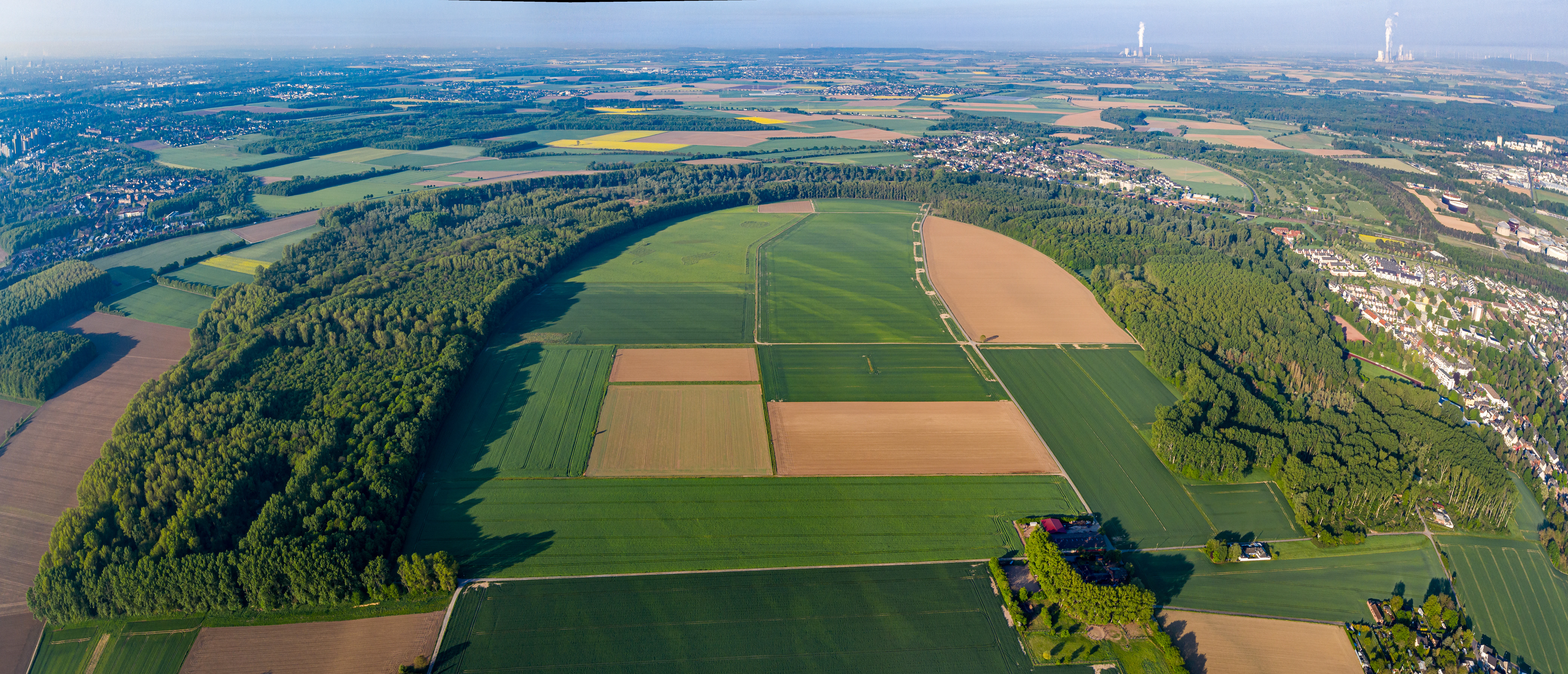
A wide aerial panoramic shot showing a dense, curved band of forest surrounding a mix of agricultural fields near a suburban area.
An aerial panoramic view of the Worringer Bruch nature reserve near Cologne.

Worringer Bruch history and protected-area timeline

The landscape history of Worringer Bruch is largely a story of geological change along the Lower Rhine rather than direct human planning. The defining event took place about 8,000 years ago, when the meander that forms today's wetland was cut off from the main course of the Rhine. Over the following millennia, the isolated river bend gradually silted up and developed into the swampy lowland that is now the reserve's core feature.

The name of the area itself comes from the adjacent Cologne district of Worringen, a settlement with a documented history stretching back to at least 922 AD and a long tradition as an independent town before becoming part of Cologne. The relationship between the wetland and the surrounding farmland has long been one of slow mutual adjustment, with orchards, pastures, and forest patches shaped by traditional land use over many centuries.

The decisive moment in the modern history of the site came in 1991, when the area was officially designated as a Naturschutzgebiet under the designation NSG K-009, securing its long-term protection from more intensive development. In subsequent decades, the area was also integrated into the European Natura 2000 network under the designation DE-4907-301, recognizing its role within the wider transnational system of protected habitats. A separate, more somber episode in the reserve's recent public history occurred in October 2001, when an unidentified female body was discovered in the difficult-to-access terrain, a case that has remained unsolved and is still listed publicly in regional missing persons appeals.

Worringer Bruch landscape and geographic character

The landscape of Worringer Bruch is shaped almost entirely by the former meander of the Rhine and the long processes of siltation that followed. The terrain lies low and flat, with much of the ground only a few tens of centimeters above or below the prevailing water table, and elevations within the reserve reach just about 37.5 meters above sea level, a figure that marks the lowest natural point within the entire city limits of Cologne.

The substrate is consistently moist or even waterlogged in many places, producing a patchwork of shallow open water, reedy marsh, wet grassland, and deciduous floodplain forest. Softwood species such as willow and poplar dominate the lowest, wettest patches, while slightly higher ground carries mixed hardwood stands, including oak and ash, along with transitional thickets. Cultural landscape elements are integrated into this natural framework rather than separated from it: orchards, meadows, and small pasture areas in and around the wet core create a gradual edge between the strictly protected wetland and the adjoining farmland.

Hydrologically, the area remains tied to the Rhine, even though the active river channel now lies some three kilometers to the east. Seasonal and multi-year fluctuations in the main river's water level still influence the groundwater beneath the old meander, and this continuing connection is one of the reasons the wetland retains its distinctive character. Overall, the landscape reads less as a dramatic natural landmark and more as a quiet, low-lying mosaic of water, marsh, meadow, and forest.
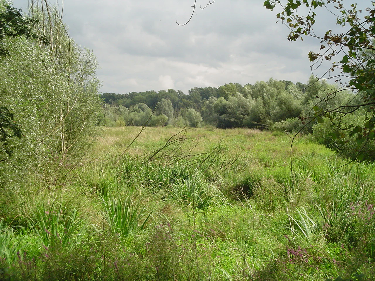
A green, grassy wetland meadow in the foreground with a line of dense deciduous trees in the background under a cloudy sky.
A view of the wetland vegetation and surrounding trees within the Worringer Bruch nature reserve.

Worringer Bruch ecosystems, habitats, and plant life

Ecologically, Worringer Bruch is best understood as a floodplain mosaic. The reserve combines the major habitat types typical of the Lower Rhine: relict oxbow water bodies in varying stages of overgrowth, extensive reed and sedge zones, softwood and hardwood floodplain forest, and open grassland areas managed in more traditional ways. This range of habitats within a relatively compact area, in a region that is otherwise heavily shaped by human activity, gives the site a particular importance.

The vegetation pattern is closely tied to water levels. The wettest depressions support reeds, sedges, willows, and poplars, while slightly higher ground carries more diverse deciduous forest with oak and ash. Along the edges of the wetland, the transition into cultural landscape is marked by orchards, hedges, and meadows, which function both as part of the historic land use and as habitat structures for insects, small mammals, and breeding birds.

Because much of the reserve is seasonally flooded or soft underfoot, large areas have effectively been left to their own dynamics, allowing natural succession to play out alongside the more traditional managed areas. That balance between unmanaged wet core and traditionally used margins is one of the defining ecological features of the site, and it gives the reserve a strong identity within the larger network of protected floodplain sites in North Rhine-Westphalia.

Worringer Bruch wildlife and species highlights

The combination of difficult-to-access terrain, varied wetland habitats, and relative quiet within a built-up region has allowed Worringer Bruch to support a surprisingly rich animal community for such an urban setting. The reserve has significant value for amphibians, including species such as the common toad and the crested newt, as well as for slow worms and several bat species that use the mix of forest, water, and orchard structures as foraging habitat.

Bird life is one of the most visible aspects of the reserve. Among the species recorded here are the nightingale, the golden oriole, the marsh harrier, the black woodpecker, the long-eared owl, and the honey buzzard, all of which depend on the combination of mature trees, dense undergrowth, and open wetland that the floodplain mosaic offers. The reed zones and wet meadows provide feeding and nesting habitat for a range of water-associated birds, while the surrounding orchard and forest patches support woodland species.

Mammals present in the area include the nutria, a rodent originally from South America that has become established along many Rhine floodplain sites, as well as raccoon, an introduced species that is now widely present in the Rhine-Ruhr region. The presence of these non-native species alongside the native amphibian and bird fauna adds a further conservation dimension, since they can influence the population dynamics of more sensitive native species.

Worringer Bruch conservation status and protection priorities

Worringer Bruch carries substantial weight within the regional conservation framework of North Rhine-Westphalia. Since its designation as a Naturschutzgebiet under the code K-009 in 1991, the area has been managed with the primary goal of preserving its floodplain habitats and the species that depend on them. The status gives the site firm protection against conversion, drainage, or other forms of intensive development that have affected many comparable floodplain areas.

The reserve is also formally part of the European Natura 2000 network under the identifier DE-4907-301, which links it to broader transnational efforts to safeguard habitat types and species of community interest. This means that management decisions are evaluated not only at the level of Cologne or North Rhine-Westphalia, but also within the wider European context of protected natural areas.

Conservation importance goes beyond legal status. The reserve serves as one of the last large, ecologically intact floodplain complexes inside the built-up area of Cologne, and it provides a regionally significant refuge for amphibians, wetland birds, and bats against a backdrop of heavily altered surroundings. Its role as one of the so-called 'green lungs' of Cologne and as a key piece of the Lower Rhine floodplain system gives it long-term value for biodiversity conservation, ecological connectivity, and public engagement with nature.

Worringer Bruch cultural meaning and human context

The cultural identity of Worringer Bruch is tightly interwoven with the adjacent Cologne district of Worringen, whose first documented mention dates to 922 AD and which long retained the character of an independent town. The wetland itself, however, has historically been less a center of settlement than a landscape to be used carefully: as wet pasture, source of reed and wood, and a difficult terrain that people generally avoided.

The traditional cultural elements still visible in and around the reserve, including orchards, meadows, and small-scale pasture, reflect this long relationship between the village and its wetland edge. These features are not decorative additions but genuine components of how the landscape was shaped over generations, and they continue to play a role in maintaining habitat diversity. The reserve today sits within an urban setting that is itself strongly layered historically: Cologne, Worringen, and the Lower Rhine have all left traces on how the area is perceived and used.

Top sights and standout views in Worringer Bruch

A preserved old Rhine meander from around 8,000 years ago, now a swampy, forested wetland and the lowest point of Cologne. A nature reserve since 1991 and part of the European Natura 2000 network, forming one of the most important inner-city floodplain refuges in the Rhine-Ruhr region.

A mosaic of softwood and hardwood floodplain forest, reed marsh, wet meadows, orchards, and pasture that creates habitat for amphibians, bats, and a wide range of birds, from nightingales and golden orioles to marsh harriers and black woodpeckers, all within easy reach of a major European city.

Best time to visit Worringer Bruch

Spring and early summer tend to be especially rewarding at Worringer Bruch, when water levels are often moderate, vegetation is at its most varied, and the breeding season brings high bird activity across the reed zones and forest patches. The combination of fresh foliage and active birdlife makes this period particularly good for visitors interested in observing the area's wildlife.

Late summer and early autumn offer a quieter character, with warmer drier surfaces on the higher paths and good conditions for walking and exploring the edges of the wetland. Wet ground can limit access to some of the more remote parts of the reserve at any time of year, and visitors should treat the site as a quiet nature area rather than a destination with extensive trail infrastructure.


Monthly climate preview

Long-term representative averages tracking twelve-month weather patterns across the protected landscape

Worringer Bruch Climate Normals: Annual Temperature and Precipitation Rhythm

Worringer Bruch maintains a measured annual temperature and precipitation rhythm derived from thirty-year observational averages at a representative coordinate. Examining the complete monthly climate profile reveals detailed temperature bounds and precipitation rates for comprehensive geographical analysis.
Annual mean10 °C
1 °C19 °C
Jan
Feb
Mar
Apr
May13°
Jun17°
Jul19°
Aug19°
Sep15°
Oct10°
Nov
Dec
Warmest month
July

19.2 °C

Coolest month
January

1.3 °C

Wettest month
December

2.6 mm/day

Driest month
April

1.6 mm/day

Park location guide

Geography guide, regional context, and park location map for Worringer Bruch

Worringer Bruch park geography, regions, and map view in Germany

Understand where Worringer Bruch sits in Germany through a broader geographic reading of the surrounding landscape, nearby location context, and its mapped position within the national park landscape.

How Worringer Bruch fits into Germany

Germany is a federal republic in Western and Central Europe with a population of over 83 million across sixteen constituent states. It is Europe's largest economy by nominal GDP and a major global exporter and importer. The capital is Berlin, and the country borders Denmark, Poland, Czech Republic, Austria, Switzerland, France, Luxembourg, Belgium, and the Netherlands.

Wider geography shaping Worringer Bruch in Germany

Germany is located in Western and Central Europe, spanning 357,022 km². It borders Denmark to the north, Poland and the Czech Republic to the east, Austria and Switzerland to the south, and France, Luxembourg, Belgium, and the Netherlands to the west. The country has coastlines on the Baltic Sea and North Sea to the north, with the Alps located in the southern region.

Map view of Worringer Bruch

Use this park location map to pinpoint Worringer Bruch in Germany, understand its exact geographic position, and read its mapped placement within the surrounding landscape more clearly.

Pigeon | © OpenStreetMap contributors

Location context for Worringer Bruch

North Rhine-Westphalia
Recorded earthquake history

Examine Recorded Earthquake History Near the Worringer Bruch Nature Reserve

Review the documented collection of seismic events associated by location with the Worringer Bruch wetlands. This MoriAtlas resource provides a transparent, chronological view of historical earthquake data to support regional geographic and seismic understanding for this North Rhine-Westphalia site.

Worringer Bruch Earthquake History

Catalogued events

32 events

Strongest magnitude

Magnitude 4.3

Most recent event

Dec 8, 2008

This history includes earthquakes recorded inside the park or within 50 km of its borders

Explore protected wetland habitats, swamp forests, and low-lying floodplain terrain.

Worringer Bruch Landscape Photos: Visual Guide to the Ancient Rhine Meander

Examine detailed imagery showcasing the unique wetland environment, relict oxbow meanders, and dense floodplain vegetation of Worringer Bruch. Visual documentation reveals the distinct terrain and habitat structures that define this protected nature reserve.

A wide aerial panoramic shot showing a dense, curved band of forest surrounding a mix of agricultural fields near a suburban area.

A calm, shallow body of water in a wetland area containing numerous fallen logs and branches; the background features a dense line of green forest under an overcast sky.

A green, grassy wetland meadow in the foreground with a line of dense deciduous trees in the background under a cloudy sky.

Park atlas

Compare nearby protected areas and regional wetland habitats across North Rhine-Westphalia

Explore Parks Near Worringer Bruch and Other Protected Landscapes

Visitors comparing Worringer Bruch can browse adjacent nature reserves and regional conservation areas across the surrounding landscape. Evaluating these connected lowland habitats provides deeper context for regional floodplain ecology and wetland preservation.
A horizontal watercolor painting depicting a gentle, hazy green landscape with rolling hills, a line of trees, and a foreground meadow.
Protected landscapeNorth Rhine-Westphalia
2.2 km away#1 closest

South

Naturpark Rheinland: Geography and Protected Area Overview in North Rhine-Westphalia

A complex metropolitan nature park and lake district

Naturpark Rheinland represents a distinct convergence of reclaimed lignite mining landscapes, quiet lowland forests, and floodplain wetlands. Its mapped boundaries reveal a diverse terrain of ridges and river valleys that define the environmental character of the Cologne-Bonn metropolitan region.

Area
1,045 km²
Established
1959
Relief
Upland
Climate
Temperate
Nature reserveLeverkusen
About 4.1 km away#2 closest

Northeast

Krapuhlsee Nature Reserve: Protected Wetland and Gravel Lake Geography in Leverkusen

Exploring post-industrial habitat mosaics and conservation terrain

Krapuhlsee is a protected nature reserve in Leverkusen, North Rhine-Westphalia, known for its unique concentration of post-mining gravel lakes and nutrient-poor grassland habitats. Managed to support rare wild bee populations and ground-nesting birds, the reserve acts as a critical stepping-stone for ecological connectivity across the heavily industrialized Rhine corridor.

Area
0.082 km²
Established
1986
IUCN
IV
Relief
Lowland
Watercolor illustration of a peaceful lake with trees on a small island and flowering meadows in the foreground.
Nature reserveNordrhein-Westfalen
About 4.4 km away#3 closest

Northeast

Monheimer Baggersee Nature Reserve: Geographic Overview and Protected Landscape Mapping

Located within the Lower Rhine terrace of Nordrhein-Westfalen

Monheimer Baggersee represents a vital protected landscape shaped from a former gravel quarry. This reserve provides a comprehensive geographic look at mineral-substrate habitats, irregular lake shorelines, and specialized avian breeding grounds within the urbanized Mettmann district.

Area
0.712 km²
Established
1981
IUCN
IV
Relief
Lowland
Nature reserveNordrhein-Westfalen
About 7 km away#4 closest

East

Wupperinsel Nature Reserve: Mapped Protected Landscapes in Nordrhein-Westfalen

Riparian woodland, floodplain islands, and meadow habitats.

Discover the geographic role of Wupperinsel as a designated nature reserve within the Wupper River corridor. This site features a rare Glatthafer meadow, mature poplar lines, and mixed-woodland groves that provide essential habitat connectivity. Analyze the protected island boundaries and the layered floodplain terrain that characterize this significant ecological fragment in urban Germany.

Area
0.054 km²
Established
1987
IUCN
IV
Watercolor painting of a pastoral landscape featuring a winding river, green fields, and clusters of trees, rendered in a soft, impressionistic style on a white background.
Nature reserveNordrhein-Westfalen
About 8.5 km away#5 closest

Northeast

Southerberg Nature Reserve: Protected Woodland and Wetland Mosaic in Nordrhein-Westfalen

A rare habitat bridge on the Bergische Sand terrace.

Southerberg serves as a crucial nature reserve in Leverkusen, Nordrhein-Westfalen, balancing wet birch-oak forests with reedbeds and meadows. This compact protected area functions as a key ecological connector between larger regional habitats, showcasing a refined topographic transition from valley basin to sandy slope.

Area
0.149 km²
Established
1987
IUCN
IV
Relief
Lowland
A watercolor illustration of a gentle, winding stream through a green, hilly valley with deciduous and coniferous trees, against a background of soft, blue-toned mountains.
Nature reserveNordrhein-Westfalen
About 8.5 km away#6 closest

Southwest

Kernzone Ommelstal: Geographic Overview of the Protected Nature Reserve in Germany

A stream-valley mosaic within the Nordrhein-Westfalen loess plains.

Kernzone Ommelstal acts as a localized sanctuary of wet woodlands, ponds, and marshy ground situated in the fertile farming landscapes of Nordrhein-Westfalen. This 14-hectare reserve serves as a critical study of how small-scale landscape incisions, shaped by the Fliestedener Bach, create essential niches for habitat protection in intensively cultivated regions.

Area
0.143 km²
Established
2017
IUCN
IV
Nature reserveNordrhein-Westfalen
About 11 km away#7 closest

East

Wupperhang mit Henkensiepen und Hüscheider Bachtal Protected Area and Geographic Atlas

Forested river valleys and slopes in Nordrhein-Westfalen

Investigate the detailed geography of Wupperhang mit Henkensiepen und Hüscheider Bachtal, a nature reserve showcasing prime Hainsimsen beech forest and riparian habitats. The area represents a key ecological corridor along the Wupper River, featuring rugged side valleys, calcareous springs, and diverse floodplain vegetation that defines this protected woodland segment of the Bergisches Land.

Area
34.65 km²
Established
1985
IUCN
IV
A minimalist watercolor painting showing stylized green trees and rolling hills against a pale, soft-colored background.
Nature reserveNordrhein-Westfalen
About 11 km away#8 closest

North

Schlosspark Benrath Nature Reserve in Nordrhein-Westfalen: A Geographic and Landscape Atlas

Examining historic baroque design and floodplain woodland ecosystems.

Schlosspark Benrath encompasses a vital protected area where rococo architectural layout meets ecologically diverse floodplain forest. Known for its star-shaped linden avenues, ancient yew understory, and significant deadwood habitats, this reserve functions as a crucial green corridor within the lower Rhine terrace, supporting a wide range of bird species and rare beetles.

Area
0.443 km²
Established
2016
IUCN
IV
Relief
Lowland

Common questions about visiting, size, designation, and location context for Worringer Bruch

Worringer Bruch FAQs for park facts, access, geography, and protected area context

Find quick answers about Worringer Bruch, including protected-area facts, park geography, trail and visitor context, and how the park fits into its surrounding country and regional landscape.
MoriAtlas Explorer

Continue Your Protected Areas Search Across the Global Atlas

Deepen your exploration by continuing the structured search for national parks and protected areas worldwide. Utilize the comprehensive filtering capabilities to compare different conservation landscapes and refine your understanding of global park geography. Discover more about the distribution and characteristics of protected natural areas.

Global natural geography