
Mori Atlas logo
Nature reserveKiesgrube bei Baumbach

A restored river meander habitat featuring floodplain forests and engineered shoreline ecosystems

Kiesgrube bei Baumbach Nature Reserve: Mapped Wetland Landscapes and Geography in Germany

Kiesgrube bei Baumbach serves as a significant nature reserve along the middle Fulda valley in northern Hesse, Germany. This protected landscape, established within a former gravel quarry, provides a complex habitat mosaic defined by shallow-water zones, willow-fringed banks, and developing floodplain woodland. The site functions as a vital wetland refuge within the broader Auenverbund Fulda, showcasing the ecological evolution of post-industrial riparian terrain.

gravel-pit lakeformer quarrywetland reservewaterbird habitatfloodplain forestriparian woodland
A stylized vector illustration showing a mountain valley with a tall waterfall cascading down pink and yellow cliffs into a winding river, surrounded by green trees and meadows.

Kiesgrube bei Baumbach

Nature reserve

Park overview

Structured park overview, official facts, and landscape profile for Kiesgrube bei Baumbach

Kiesgrube bei Baumbach park facts, protected area profile, and essential visitor context

Review the core facts for Kiesgrube bei Baumbach, including designation, size, terrain, visitor scale, habitats, and operating context in one park-focused overview.

About Kiesgrube bei Baumbach

Kiesgrube bei Baumbach is a compact but ecologically layered protected area in the northern Hessian section of the Fulda valley. Geographically it sits inside a river meander, where the Fulda has shaped a wide floodplain landscape of meadows, riparian woodland, and former gravel workings. The reserve's defining feature is a gravel-pit lake whose banks were modelled during ongoing extraction to support biodiversity, a process that blended industrial activity with ecological design.

The site's identity is inseparable from the broader Auenverbund Fulda, a landscape protection area along the Fulda that links meadows, riverbanks, and remnant wetlands across several districts. Within this wider floodplain context, the former quarry area stands out for its sharp habitat transitions, with open water giving way to flat gravel beaches, successional willow stands, and ultimately closed floodplain forest. Even though the lake itself is relatively small, its shoreline length and structural variety give it a disproportionate importance for wildlife.

As a visitor experience, the reserve is primarily quiet and observational rather than recreational. Birdwatchers, walkers, and cyclists encounter it in passing, especially along the Fulda cycle route that skirts the northern tip of the protection area. The reserve's value lies less in dramatic scenery than in the richness of its birdlife, the visible story of post-industrial landscape restoration, and its role within a connected network of protected floodplain sites along the Fulda.

Quick facts and research context for Kiesgrube bei Baumbach

Kiesgrube bei Baumbach lies north of the village of Baumbach, a district of Alheim in the Landkreis Hersfeld-Rotenburg in Hesse. The reserve sits inside a loop of the River Fulda and forms part of the larger Auenverbund Fulda landscape protection area. It was designated as a Naturschutzgebiet in March 1995 by the Regierungspräsidium Kassel, covers roughly 23 hectares, and carries national identifier 1632026 and WDPA code 164074.

Protection and recognition

Documented terrestrial protection scope and baseline designation data

Kiesgrube bei Baumbach Protection Status and Designation History

Kiesgrube bei Baumbach maintains a documented terrestrial protection status established in the designated year 1995. Official records provide structural conservation data for analyzing management scope and international recognition without external assumptions.

Protection details

Protection scope
Terrestrial
Designated year
1995
Transboundary protection
No
WDPA ID
164074
Park context

Deeper park guide and search-rich context for Kiesgrube bei Baumbach

Kiesgrube bei Baumbach history, landscape, wildlife, and travel context

Explore Kiesgrube bei Baumbach through its history, landscape character, ecosystems, wildlife, conservation priorities, cultural context, and seasonal travel timing in a structured park guide built for atlas discovery and search intent.

Why Kiesgrube bei Baumbach stands out

The reserve is best known for being an artificially created but ecologically rich wetland that emerged from a former gravel quarry. Its combination of shallow-water gravel-pit lake, engineered shore profiles, willow-dominated bank vegetation, and developing floodplain forest makes it one of the more distinctive bird habitats along the middle course of the Fulda, once attracting unusually high counts of protected waterbird species for the region.
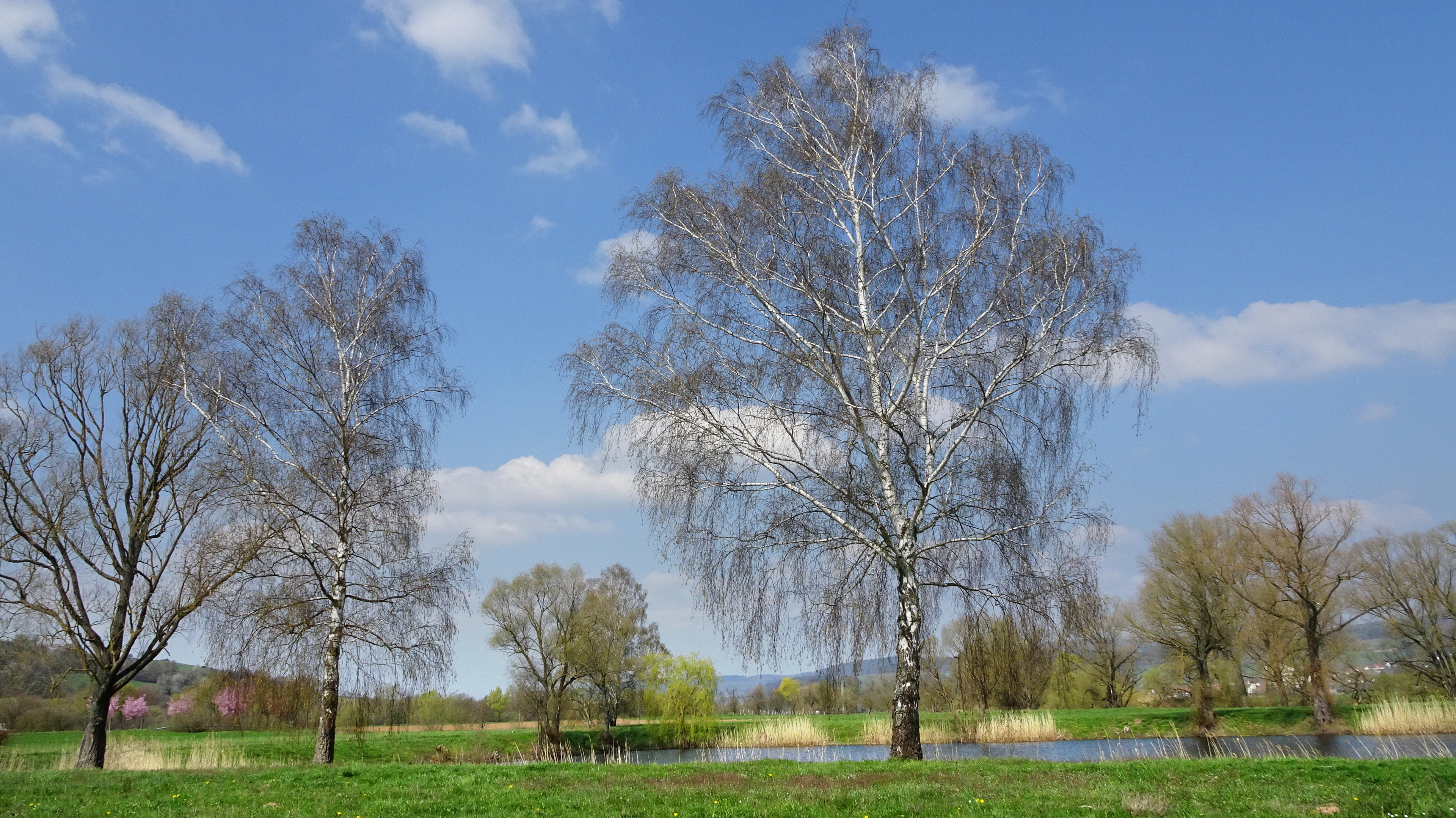
A wide landscape view of a green meadow with several tall, bare trees with white bark and a body of water in the mid-ground under a blue sky with scattered white clouds.
View of the Fulda floodplain near Baumbach showing birch trees and a water body under a blue sky.

Kiesgrube bei Baumbach history and protected-area timeline

The reserve originated from active gravel extraction in a Fulda meander near Baumbach. While extraction was still underway, conservation groups worked with the gravel operator to plan and implement reshaping of the shoreline. The area was acquired as part of compensation measures linked to the upgrade of a railway line, and the funds enabled the creation of flat banks, bays, shallow-water zones, and small islands.

Members of the Hessische Gesellschaft für Ornithologie und Naturschutz oversaw the reshaping work, which followed a regeneration plan designed to maximize habitat diversity. By 2003, the site had recorded 65 bird species, including 22 protected under the European Birds Directive, a remarkable figure that placed it among the leading bird observation areas in the middle Fulda valley.

Formal protection came in March 1995 when the Regierungspräsidium Kassel designated the gravel pit and its banks as a nature reserve. The intent was to safeguard the site as a long-term breeding, resting, and feeding area for birds, as well as a refuge for rare and threatened plant and animal species. Over the following decades, the character of the reserve shifted as floodplain forest gradually replaced open shorelines, a natural succession that eventually altered its bird community.

Kiesgrube bei Baumbach landscape and geographic character

The reserve occupies a classic Fulda river-meander landscape, with the river looping around the gravel-pit site to create a sheltered floodplain setting. The terrain itself is low-lying and relatively flat, sitting at about 179 metres above sea level, and is dominated less by dramatic relief than by the contrast between water, banks, and developing forest.

Artificially created landforms are central to the site's character. During restoration, engineers and conservationists shaped shallow littoral zones, inlets, and small islands, deliberately building in habitat edge between water and land. As extraction ceased, softwood floodplain forest dominated by willows colonized the previously bare banks, producing today a closed fringe of willow thickets whose branches reach out over the water.

In wider landscape terms, the reserve belongs to the Fulda-Werra-Bergland natural region, specifically the Rotenburger Fuldatal sub-unit of the eastern Hessian hill country. Outside its boundaries the protected area sits within the larger Auenverbund Fulda landscape protection area, which preserves floodplain meadows and riverside habitat across much of the Fulda between the districts bordering the river.
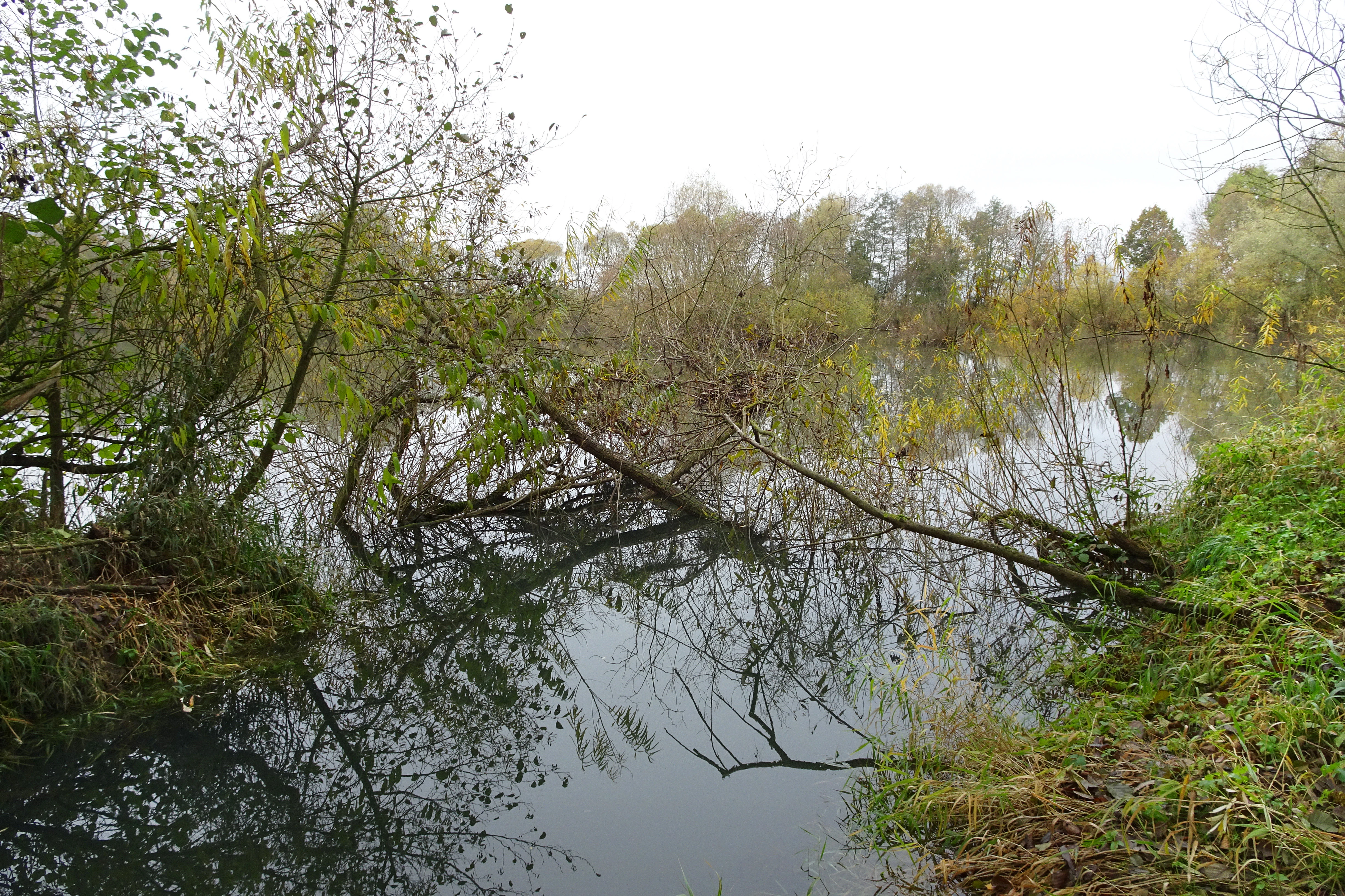
A calm body of water surrounded by green trees and bushes, with fallen branches extending over the surface and reflecting in the water under an overcast sky.
A calm water body in the Kiesgrube bei Baumbach nature reserve, featuring fallen branches and surrounding vegetation reflected in the water under an overcast sky.

Kiesgrube bei Baumbach ecosystems, habitats, and plant life

Ecologically, Kiesgrube bei Baumbach is a textbook example of how a heavily modified site can be redesigned for biodiversity. The reserve's core habitat is the former gravel-pit lake itself, ringed by willow-rich bank vegetation that has matured into softwood floodplain forest. Small islands, bays, and flat shores that were deliberately shaped during restoration still influence the shoreline character, even though much of the original open bank has now closed over.

The successional shift from open gravel banks to closed willow forest is one of the site's defining ecological dynamics. In its earliest post-restoration phase, the open shoreline attracted wading birds and other ground-nesting species. As willows gained ground, those open habitats disappeared, and the reserve's bird community shifted toward species that nest in or near the overhanging branches of willow thickets. The site has so far retained little true marshland with reed beds and floating-leaf zones, which limits nesting opportunities for certain waterbirds.

More broadly, the reserve benefits from its position within the Auenverbund Fulda floodplain landscape. Meadow, riparian woodland, and the gravel-pit lake combine to create a complex habitat mosaic that supports both wetland and forest-edge species, even within an area of just over 20 hectares.

Kiesgrube bei Baumbach wildlife and species highlights

The reserve's wildlife profile is overwhelmingly shaped by its bird community. By 2003, observers recorded 65 bird species, 22 of which are protected under the European Birds Directive, a level of diversity that gave the reserve a leading position among around seventy bird-observation sites in the middle Fulda valley. This richness directly reflects the site's mix of open water, flat shore, willow thickets, and developing floodplain forest.

As the open banks have closed over, the dominant bird groups have shifted. Wading birds that once used the bare gravel shores in large numbers have largely left, and only a few waterfowl still nest in the shelter of the low-hanging willow branches. Regular visitors today include little grebes, grey herons and great egrets, cormorants, goosanders, tufted ducks and common pochards, ospreys, common sandpipers, and kingfishers, all of which are recorded as regular passage or resting birds.

Beyond birds, the reserve's mix of water, softwood forest, and adjacent floodplain meadows supports a broader fauna typical of Hessian riverine landscapes. The site's value to wildlife is less about charismatic single species than about sustaining a multi-layered habitat in which seasonal migrants, breeding waterbirds, and woodland-edge species can coexist.

Kiesgrube bei Baumbach conservation status and protection priorities

Kiesgrube bei Baumbach is a clear case study in how industrial land use and conservation planning can intersect productively. The reserve originated from a gravel quarry whose banks were deliberately reshaped to develop varied habitats, an early example of integrating biodiversity goals into an active extraction site. Its acquisition was funded through compensation measures tied to the expansion of a railway line, illustrating how transport infrastructure projects in Germany can directly produce new high-value nature reserves.

From a conservation perspective, the reserve's significance lies in three overlapping factors: its structural diversity, its role within the wider Auenverbund Fulda floodplain network, and its track record of supporting protected bird species. Even at only about 23 hectares, the combination of open water, islands, willow thickets, and floodplain woodland has produced bird figures that rival much larger sites.

The reserve is currently managed by the Hessian forestry office in Rotenburg together with volunteer conservation workers. Their task includes continuing to track the ongoing vegetation change, particularly the gradual conversion of open shoreline to closed floodplain forest, and balancing that dynamic against the reserve's original objectives as a breeding, feeding, and resting area for waterbirds.

Top sights and standout views in Kiesgrube bei Baumbach

Kiesgrube bei Baumbach stands out as a former working quarry that has been deliberately redesigned into one of the more notable small wetland reserves along the middle Fulda. Its combination of engineered shoreline, willow-fringed lake margins, and developing floodplain forest creates a compact but well-structured habitat mosaic. Integrated into the wider Auenverbund Fulda landscape protection area, it functions both as an independent reserve and as a node within a broader floodplain conservation network.

Best time to visit Kiesgrube bei Baumbach

The reserve is best appreciated during the bird migration seasons, when spring and autumn passages bring the highest diversity of waterbirds and raptors to the lake. Spring is generally the most rewarding period for breeding species, while late summer and early autumn offer good conditions for observing passage birds against still-open sections of shoreline. Winter can produce sightings of hardy waterfowl and occasional raptors, and the willow-dominated banks give the site a quiet, atmospheric character even outside the peak birding months.

Monthly climate preview

Long-term temperature ranges and precipitation patterns across twelve months

Kiesgrube bei Baumbach Climate Normals and Monthly Weather Records

Kiesgrube bei Baumbach records measured monthly temperature variations alongside steady precipitation rates from representative coordinate sampling between 1991 and 2020. Reviewing the comprehensive monthly climate profile allows detailed comparison of long-term weather patterns and thermal averages across the protected area.
Annual mean9 °C
-1 °C19 °C
Jan-1°
Feb
Mar
Apr
May12°
Jun16°
Jul19°
Aug18°
Sep14°
Oct
Nov
Dec
Warmest month
July

18.6 °C

Coolest month
January

-0.8 °C

Wettest month
July

2.5 mm/day

Driest month
April

1.4 mm/day

Park location guide

Geography guide, regional context, and park location map for Kiesgrube bei Baumbach

Kiesgrube bei Baumbach park geography, regions, and map view in Germany

Understand where Kiesgrube bei Baumbach sits in Germany through a broader geographic reading of the surrounding landscape, nearby location context, and its mapped position within the national park landscape.

How Kiesgrube bei Baumbach fits into Germany

Germany is a federal republic in Western and Central Europe with a population of over 83 million across sixteen constituent states. It is Europe's largest economy by nominal GDP and a major global exporter and importer. The capital is Berlin, and the country borders Denmark, Poland, Czech Republic, Austria, Switzerland, France, Luxembourg, Belgium, and the Netherlands.

Wider geography shaping Kiesgrube bei Baumbach in Germany

Germany is located in Western and Central Europe, spanning 357,022 km². It borders Denmark to the north, Poland and the Czech Republic to the east, Austria and Switzerland to the south, and France, Luxembourg, Belgium, and the Netherlands to the west. The country has coastlines on the Baltic Sea and North Sea to the north, with the Alps located in the southern region.

Map view of Kiesgrube bei Baumbach

Use this park location map to pinpoint Kiesgrube bei Baumbach in Germany, understand its exact geographic position, and read its mapped placement within the surrounding landscape more clearly.

Pigeon | © OpenStreetMap contributors

Visual reference of former gravel-pit lakes, willow thickets, and floodplain forest habitats

Kiesgrube bei Baumbach Photos, Scenery, and Wetland Landscapes

Visual records capture the distinctive shoreline morphology and wetland habitats of Kiesgrube bei Baumbach within the Fulda river valley. Photographic documentation reveals the ecological transition from former industrial extraction pits to sheltered waterbird refuges and riparian woodland ecosystems.

A wide landscape view of a green meadow with several tall, bare trees with white bark and a body of water in the mid-ground under a blue sky with scattered white clouds.

A small dark pond surrounded by leafless trees and green ground vegetation in a wooded area.

A calm body of water surrounded by green trees and bushes, with fallen branches extending over the surface and reflecting in the water under an overcast sky.

Park atlas

Compare adjacent wetland reserves and river valley landscapes across the region

Exploring Other Parks Near Kiesgrube bei Baumbach and Surrounding Protected Areas

Continue geographic discovery by comparing Kiesgrube bei Baumbach with other protected areas located throughout the surrounding Fulda valley terrain. Examining adjacent wetland reserves and river valley habitats provides broader regional context for post-industrial conservation landscapes.
A soft, panoramic watercolor painting depicting a green floodplain with a winding river, scattered trees, and rolling hills in the distance.
Nature reserveSchwalm-Eder-Kreis
About 2.4 km away#1 closest

Northwest

Fuldatal bei Konnefeld: Protected Floodplain and Wetland Geography in Schwalm-Eder-Kreis

An essential river valley habitat and nature reserve in northern Hesse

Fuldatal bei Konnefeld is a compact, high-value nature reserve situated along the Fulda river valley. The landscape is defined by its old river oxbows, soft-wood forest galleries, and species-rich hay meadows. This resource provides a focused geographic overview of its protected status as a Natura 2000 site and its function as a vital wildlife corridor.

Area
0.169 km²
Established
1989
IUCN
IV
Relief
Lowland
A pale, panoramic watercolor painting of a wetland landscape with a row of trees on the right side and low hills in the distance.
Nature reserveLandkreis Hersfeld-Rotenburg
About 3.9 km away#2 closest

Southeast

Im Sand bei Rotenburg Nature Reserve: Mapping the Fulda River Floodplain and Wetland Mosaic

A structured floodplain refuge in Landkreis Hersfeld Rotenburg

Located in the low-lying reaches of the Fulda River, Im Sand bei Rotenburg represents a significant shift from industrial land use to a protected, structurally rich riverine mosaic. The area features a complex of water-filled pits, reedbeds, and alluvial forest patches that serve as a crucial migratory stopover for diverse waterbird populations in northeastern Hesse.

Area
0.102 km²
Established
1997
IUCN
IV
Relief
Lowland
A soft, painterly watercolor landscape showing a green grassy meadow beside a calm lake with a stand of trees and rolling hills in the background.
Nature reserveLandkreis Hersfeld-Rotenburg
About 8.9 km away#3 closest

Southeast

Forbachsee bei Bebra Nature Reserve: Mapped Protected Landscape in Landkreis Hersfeld-Rotenburg

River-connected gravel-pit lake and floodplain geography

Analyze the protected boundaries of Forbachsee bei Bebra, a nature reserve defined by its active connection to the River Fulda. The site features an evolving shoreline of gravel banks and softwood forest, showcasing how industrial extraction areas mature into essential refuges for migratory waterbirds within the larger regional valley system.

Area
0.219 km²
Established
1985
IUCN
IV
Relief
Lowland
A horizontal watercolor painting depicting a soft-toned, rolling landscape with green meadows, distant tree lines, and a light-filled sky.
Nature reserveHesse
About 12 km away#4 closest

Southwest

Roßbachtal bei Völkershain Nature Reserve: Geography and Protected Valley Landscapes

Stream-fed meadow and forest habitats in Hesse

Located in the Schwalm-Eder-Kreis, Roßbachtal bei Völkershain encompasses a linear valley environment within the Knüllgebirge. The reserve tracks the Roßbach stream as it moves toward the Breitenbach, featuring a protected alignment of meadows and slopes that serves as a focused habitat management area in central Germany.

Area
1.141 km²
Established
1988
IUCN
IV
Watercolor painting of a river landscape with lush green vegetation and soft pink hills in the background.
Nature reserveLandkreis Hersfeld-Rotenburg
About 13 km away#5 closest

Southeast

Alte Fulda bei Blankenheim Nature Reserve: Mapping the Fulda Valley Floodplain Ecosystem

Protected riparian landscapes in Landkreis Hersfeld-Rotenburg

Alte Fulda bei Blankenheim is a vital nature reserve featuring a restored oxbow, wet meadows, and secondary flood channels. This site showcases the intersection of traditional land management and modern wetland conservation within the broader landscape of the Fulda valley. Explore the boundaries, terrain, and regional geography of this important Hessian bird sanctuary and floodplain habitat.

Area
0.236 km²
Established
1981
IUCN
IV
Relief
Lowland
A soft, impressionistic watercolor painting of a serene landscape featuring rolling green hills, lush vegetation, and a calm, reflective lake in the foreground.
Nature reserveHesse
About 13 km away#6 closest

Southeast

In den Weiden bei Blankenheim: A Protected Wetland Sanctuary in the Hessian Fulda Valley

Mapping riparian floodplains and bird migration corridors in central Germany.

The In den Weiden bei Blankenheim nature reserve preserves a compact yet ecologically dense floodplain lake environment. Managed as a crucial component of the regional Fulda valley river corridor, it demonstrates the successful conversion of post-industrial gravel pits into a stable habitat for waterbirds, songbirds, and diverse riparian flora within the Hessian landscape.

Area
0.045 km²
Established
1983
IUCN
IV
Relief
Lowland
A horizontal watercolor painting of a serene lake bordered by a shoreline with trees and distant rolling hills against a soft background.
Nature reserveSchwalm-Eder-Kreis
About 14 km away#7 closest

West

Goldbergsee Nature Reserve and Mapped Protected Landscapes in Schwalm-Eder-Kreis

Ecological transition and inland water-body geography.

Goldbergsee stands as a prime case study of industrial renaturalization in northern Hesse. This protected nature reserve, characterized by its clear spring-fed water and successional woodland habitat, offers a window into how former open-cast mining sites evolve into ecologically balanced water bodies within the Schwalm-Eder-Kreis mountain foothills.

Established
1991
Watercolor painting of a lush, open landscape with a pond in the foreground, rolling green hills, and a forest in the background.
Nature reserveHesse
About 15 km away#8 closest

Southeast

Auf dem Ried bei Iba Nature Reserve and Protected Wetland Landscape in Northern Hesse

Mapped brook valley and wet grassland geography

Auf dem Ried bei Iba stands as a significant nature reserve in the Iba valley of eastern Hesse, Germany. This protected area preserves a rare sequence of reedbeds, marshes, and spring-fed wet meadows that sustain diverse aquatic plant communities. By maintaining the natural hydrology of the local brook system, the reserve offers a unique look at the wetland terrain and riparian geography characteristic of the Hesse hill country.

Area
0.047 km²
Established
1985
IUCN
IV
Relief
Lowland

Common questions about visiting, size, designation, and location context for Kiesgrube bei Baumbach

Kiesgrube bei Baumbach FAQs for park facts, access, geography, and protected area context

Find quick answers about Kiesgrube bei Baumbach, including protected-area facts, park geography, trail and visitor context, and how the park fits into its surrounding country and regional landscape.
MoriAtlas Explorer

Continue Your Protected Areas Search Across the Global Atlas

Deepen your exploration by continuing the structured search for national parks and protected areas worldwide. Utilize the comprehensive filtering capabilities to compare different conservation landscapes and refine your understanding of global park geography. Discover more about the distribution and characteristics of protected natural areas.

Global natural geography