

Mori Atlas logo
National parkKnysna National Lake Area

Discover the mapped boundaries and regional natural context of this key protected area.

Knysna National Lake Area National Park: South Africa's Protected Landscape and Geographic Atlas

Knysna National Lake Area National Park serves as a significant protected landscape within South Africa, offering a unique point of focus for geographic discovery. This page provides an atlas-style exploration of the park, detailing its mapped boundaries and its place within the country's natural geography. Understand the protected-area identity and the regional context that defines Knysna National Lake Area for comprehensive natural landscape exploration.

estuarycoastal protected areaGarden RouteSouth AfricaWestern Capetidal lagoon

Knysna National Lake Area

National park

Park overview

Structured park overview, official facts, and landscape profile for Knysna National Lake Area

Knysna National Lake Area park facts, protected area profile, and essential visitor context

Review the core facts for Knysna National Lake Area, including designation, size, terrain, visitor scale, habitats, and operating context in one park-focused overview.

About Knysna National Lake Area

Knysna National Lake Area occupies a distinctive position along South Africa's southern coastline, protecting the Knysna estuary and its surrounding landscapes within the Western Cape's Garden Route region. The protected area encompasses the tidal lagoon formed where the Knysna River exits to the Indian Ocean, a system characterized by the dramatic sandstone cliffs known as the Knysna Heads that mark the estuary's mouth. The area's ecological significance stems from the diversity of habitats it encompasses, ranging from open water and mudflats to marshland, dunes, and indigenous forest. This habitat mosaic supports a range of species and contributes to the broader conservation value of the Garden Route corridor. The Knysna estuary has historically served as a natural harbor and has been an important location for local communities and maritime activity. The protection of this coastal system reflects its environmental importance and its role in the regional landscape.

Quick facts and research context for Knysna National Lake Area

Knysna National Lake Area is located in the Western Cape along South Africa's Garden Route, approximately 400 kilometers east of Cape Town. The protected area centers on the Knysna estuary, a sheltered tidal lagoon guarded by the iconic Knysna Heads, two dramatic sandstone cliffs at the river mouth. The region experiences a mild Mediterranean climate with warm, dry summers and cool, wet winters. The surrounding landscape combines indigenous forest, fynbos vegetation, and coastal dunes, creating a distinctive ecological character typical of the Cape Floristic Region.

Protection and recognition

Tracking official conservation levels, management frameworks, and global designations

Knysna National Lake Area Protection Status and Protected Area Designation

Exploring the Knysna National Lake Area requires mapping its documented protection status, mixed conservation scope, and official designation history. Standardized geographic records compile international frameworks and regional management datasets to help researchers evaluate the ecological security of key coastal environments.

Protection details

Protection scope
Mixed
Park context

Deeper park guide and search-rich context for Knysna National Lake Area

Knysna National Lake Area history, landscape, wildlife, and travel context

Explore Knysna National Lake Area through its history, landscape character, ecosystems, wildlife, conservation priorities, cultural context, and seasonal travel timing in a structured park guide built for atlas discovery and search intent.

Why Knysna National Lake Area stands out

Knysna National Lake Area is best known for its dramatic coastal scenery, the iconic Knysna Heads sandstone cliffs that frame the estuary mouth, and its role as a critical habitat for marine and avian biodiversity. The estuary system supports important fish populations and serves as a feeding and breeding ground for various bird species. The surrounding indigenous forests are part of a broader forest complex that extends along the southern Cape coast, providing habitat for endemic species and contributing to the region's ecological richness.

Knysna National Lake Area history and protected-area timeline

The Knysna National Lake Area was established to protect the Knysna estuary and its surrounding coastal environments. The area's protection reflected recognition of the ecological importance of the lagoon system and the need to preserve the natural character of this part of the Garden Route coastline. Over time, the protected area has been managed as part of South Africa's national park system, with the designation providing formal protection for the coastal and estuarine habitats. The establishment of the protected area also acknowledged the region's significance for biodiversity and its value as a natural asset for the surrounding communities and visitors to the Garden Route.

Knysna National Lake Area landscape and geographic character

The landscape of Knysna National Lake Area is defined by the intersection of river, forest, and sea along South Africa's southern coast. The Knysna estuary occupies a broad tidal lagoon, flanked by marshland and mudflats that are exposed at low tide. The most striking visual feature is the Knysna Heads, a pair of towering sandstone cliffs that guard the estuary mouth and create a dramatic gateway between the protected lagoon and the open ocean. The surrounding terrain rises gently from the water's edge, with indigenous forest covering portions of the slopes and fynbos vegetation occurring on the drier ridges. The coastal setting includes elements of beach, dune, and rocky shore, contributing to the visual and ecological diversity of the protected area.

Knysna National Lake Area ecosystems, habitats, and plant life

The ecological character of Knysna National Lake Area reflects the broader patterns of South Africa's southern Cape coast, a region recognized globally for its biodiversity. The estuarine environment forms the core of the protected area, providing sheltered habitat for marine fish, crustaceans, and various invertebrate species. The mixture of open water, mudflat, reedbed, and forest edge creates diverse conditions that support different bird communities, with waterfowl, waders, and seabirds all present in the area. The surrounding indigenous forests and fynbos vegetation represent elements of the Cape Floristic Region, one of the world's six floral kingdoms and a hotspot of plant diversity. These vegetation types contribute to the ecological richness of the broader landscape and provide habitat for various terrestrial species.

Knysna National Lake Area wildlife and species highlights

Knysna National Lake Area supports notable wildlife populations, particularly in relation to birdlife and marine species associated with the estuary. The lagoon system provides important feeding and breeding habitat for various fish species, while the wetland areas and surrounding vegetation support diverse bird communities. The indigenous forest areas, though limited within the lake area itself, contribute to the broader habitat network that supports forest-dwelling species. The coastal position of the reserve also means that marine mammals may be present in the waters beyond the estuary mouth, with dolphins and seals occasionally observed in the nearshore ocean.

Knysna National Lake Area conservation status and protection priorities

The protection of Knysna National Lake Area reflects the ecological significance of South Africa's coastal and estuarine environments. The protected area contributes to the conservation of the Knysna estuary system, one of the few remaining relatively unaltered tidal lagoons along the southern coast. The habitats within the reserve form part of a broader network of protected areas along the Garden Route, a region of high conservation priority due to its biodiversity value. The protection of this coastal zone helps preserve important ecological processes, including tidal exchange, nutrient cycling, and the seasonal patterns that sustain the area's biodiversity.

Knysna National Lake Area cultural meaning and human context

The Knysna area has historical connections to indigenous Khoikhoi communities who inhabited the southern Cape coast prior to European settlement. The estuary and its productive waters would have provided resources for these local communities. The later development of Knysna as a town reflects the region's importance as a harbor and timber-processing center during the colonial period. The Knysna Heads have served as a maritime landmark and navigation point for vessels entering the estuary, contributing to the area's historical significance as part of the coastal shipping route along South Africa's southern coast.

Top sights and standout views in Knysna National Lake Area

The Knysna estuary and the iconic Knysna Heads represent the defining visual and experiential highlights of the protected area. The dramatic sandstone cliffs at the lagoon mouth create a striking entrance to the sheltered waters beyond and provide panoramic viewpoints over the coastal landscape. The estuary itself offers opportunities for exploring the productive tidal lagoon by boat, with its calm waters, marshland edges, and surrounding forest backdrop. The area's position along the Garden Route means it is accessible to visitors traveling this scenic coastal route and serves as a destination for those seeking to experience the natural landscapes of South Africa's southern coast.

Best time to visit Knysna National Lake Area

The Knysna National Lake Area can be visited throughout the year, though the seasonal patterns of the southern Cape influence the experience. Summer months from November to March bring warmer temperatures and generally dry conditions, making this a popular time for outdoor activities and estuary exploration. Winter months from June to August bring cooler temperatures and increased rainfall, which contributes to the lush quality of the surrounding vegetation but may limit some activities. The shoulder seasons of spring and autumn offer mild conditions and can provide good opportunities for visiting, with the added benefit of fewer crowds compared to the peak summer period.
Monthly climate preview

Long-term representative temperature and precipitation rhythms across twelve monthly intervals

Knysna National Lake Area Climate Normals and Annual Weather Patterns

Historical climate records for Knysna National Lake Area track measured average temperatures ranging from 13.2 degrees Celsius to 21 degrees Celsius alongside consistent daily precipitation patterns. Examining the complete monthly climatology profile provides deeper analytical insight into representative regional weather variations over time.
Annual mean17 °C
13 °C21 °C
Jan21°
Feb21°
Mar20°
Apr18°
May16°
Jun14°
Jul13°
Aug13°
Sep15°
Oct16°
Nov18°
Dec20°
Warmest month
February

21 °C

Coolest month
July

13.2 °C

Wettest month
November

1.9 mm/day

Driest month
May

1.1 mm/day

Park location guide

Geography guide, regional context, and park location map for Knysna National Lake Area

Knysna National Lake Area park geography, regions, and map view in South Africa

Understand where Knysna National Lake Area sits in South Africa through a broader geographic reading of the surrounding landscape, nearby location context, and its mapped position within the national park landscape.

How Knysna National Lake Area fits into South Africa

South Africa is the southernmost country in Africa, spanning 1.22 million km² with a population of over 63 million. The country operates with three capital cities, Pretoria (executive), Cape Town (legislative), and Bloemfontein (judicial), and is renowned for its biodiversity, national parks, and multicultural society.

Wider geography shaping Knysna National Lake Area in South Africa

South Africa occupies the southernmost region of Africa, with coastline along both the Atlantic Ocean to the west and the Indian Ocean to the east. The interior features elevated plateaus including the Highveld, with the Drakensberg escarpment marking the eastern highlands. The country shares borders with Namibia, Botswana, Zimbabwe, Mozambique, Eswatini, and Lesotho.

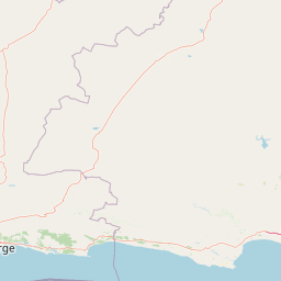
Map view of Knysna National Lake Area

Use this park location map to pinpoint Knysna National Lake Area in South Africa, understand its exact geographic position, and read its mapped placement within the surrounding landscape more clearly.

Pigeon | © OpenStreetMap contributors
Park atlas

Trace the regional context of protected coastal and forest zones along South Africa's Garden Route.

Explore Nearby Protected Areas and National Parks Surrounding Knysna National Lake Area

Browse national parks and protected areas near Knysna National Lake Area, tracing diverse coastal ecosystems and indigenous forests of the Western Cape. Gain valuable geographic context for comparing conservation landscapes, understanding regional protected-area spread, and exploring adjacent natural territories along the Garden Route.
National parkWestern Cape
Mapped park locations coincide#1 closest

Wilderness National Park: National Park in Western Cape Province, South Africa

Explore mapped protected areas and regional geography.

Wilderness National Park stands as a significant protected area within the Western Cape province of South Africa. This page provides a detailed view of its role as a national park, emphasizing its geographic placement and mapped boundaries. Understand the park's contribution to the region's natural landscape and its significance within the broader atlas of protected lands.

Area
1,210 km²
Established
2009
Relief
Lowland
Access
Easy access
National parkSouth Africa
About 0.2 km away#2 closest

Garden Route National Park: South Africa's Protected Landscape and Forest Atlas

Explore indigenous forests, coastal cliffs, and lake systems.

Garden Route National Park is a key national park in South Africa, celebrated for its rich indigenous forests and dramatic coastline. As a protected landscape, it offers a unique geographic profile, blending ancient woodlands with rugged coastal terrain and interconnected lake systems. This page serves as an atlas entry, detailing the park's spatial extent and its significance as a conservation area within the broader geography of South Africa.

Area
1,210 km²
Established
2009
IUCN
II
Relief
Mixed relief
National parkSouth Africa
About 59 km away#3 closest

East

Tsitsikamma National Park: South Africa's Protected Coastal Forest and Terrain

Explore the unique mapped landscape and protected area boundaries.

Tsitsikamma National Park in South Africa is defined by its striking coastal geography, where ancient indigenous forests descend towards rugged shores. This national park is a prime example of a protected landscape that showcases the dynamic interface between land and sea, featuring dramatic cliffs and iconic river mouths. Understanding its mapped boundaries and diverse terrain provides critical context for regional geographic exploration and the study of conservation areas within South Africa.

Established
2009
IUCN
II
Relief
Mixed relief
Climate
Mediterranean
Wildlife reserveWestern Cape
About 124 km away#4 closest

West

Gondwana Game Reserve: Geographic Overview of a Southern Cape Rewilding Landscape

Protected mountain and coastal savanna terrain in the Western Cape

Gondwana Game Reserve represents a deliberate conservation effort to restore large mammal populations to the southern coast of South Africa. Situated near the Garden Route, the reserve encompasses a complex mosaic of open plains, rolling hills, and mountain vistas, providing essential habitat connectivity for diverse wildlife species within a protected and managed ecosystem.

Area
110 km²
Relief
Mountain
Climate
Mediterranean
Access
Access unknown
Nature reserveWestern Cape
About 128 km away#5 closest

West

Gamkaberg Nature Reserve: An Atlas Overview of Mountain Geography and Protected Biomes

A vital conservation landscape within the Western Cape of South Africa.

Gamkaberg Nature Reserve stands as a focal point for ecological research and conservation in the Little Karoo. Defined by a rugged mountain range and deep gorges, the reserve protects the critical habitat of the Cape mountain zebra. Its landscape reveals an unusual overlap of four Cape biomes, offering a deep look into the regional geography and biological history of the South African interior.

Area
94 km²
Established
1974
Relief
Mountain
Climate
Mediterranean
Biosphere reserveWestern Cape
About 146 km away#6 closest

West

Gouritz Cluster Biosphere Reserve: Geographic Overview and Protected Area Boundaries

A diverse protected landscape spanning the Western Cape coastline to high mountain ridges.

Spanning from the southern African coast into the interior mountain ranges, this biosphere reserve captures an unmatched variety of landforms including estuaries, rocky headlands, and arid Karoo basins. It serves as a vital protected system for threatened species and endemic flora, representing one of the most ecologically significant landscapes within the Cape Floristic Region.

Area
31,878.9 km²
Established
2015
Relief
Mixed relief
Climate
Mediterranean
National parkEastern Cape
About 187 km away#7 closest

East

Addo Elephant National Park: South African National Park with Diverse Protected Landscapes

Explore its geographic context and unique Big Seven megafauna habitats.

Addo Elephant National Park is a crucial protected landscape within South Africa's Eastern Cape, covering approximately 1,640 square kilometers of varied terrain including karoo plains, coastal dunes, and marine protected areas. Its identity is deeply tied to the successful recovery of elephant populations and its distinction as the only African national park where all Big Seven megafauna can be observed in their natural surroundings. Discover the park's geographic spread, landscape diversity, and its role as a premier conservation area.

Area
1,640 km²
Established
1931
IUCN
II
Visitors
305.5K annual
Wildlife reserveWestern Cape
About 192 km away#8 closest

Northwest

Karoo National Park Wildlife Reserve: Mapped Boundaries and Geographic Context

Explore the protected landscape of this Western Cape wildlife reserve.

Karoo National Park stands as a protected wildlife reserve, offering insights into the natural geography of South Africa's Western Cape. This detail page provides an atlas view of its protected landscape, mapping its boundaries and situating it within its regional context. Engage with the park's identity as a conservation area and understand its geographic significance for dedicated exploration.

Area
767.9 km²
Established
1979
Relief
Mountain
Climate
Arid

Common questions about visiting, size, designation, and location context for Knysna National Lake Area

Knysna National Lake Area FAQs for park facts, access, geography, and protected area context

Find quick answers about Knysna National Lake Area, including protected-area facts, park geography, trail and visitor context, and how the park fits into its surrounding country and regional landscape.
MoriAtlas Explorer

Continue Your Protected Areas Search Across the Global Atlas

Deepen your exploration by continuing the structured search for national parks and protected areas worldwide. Utilize the comprehensive filtering capabilities to compare different conservation landscapes and refine your understanding of global park geography. Discover more about the distribution and characteristics of protected natural areas.

Global natural geography