
Mori Atlas logo
Marine protected areaKutu Parera (Gaer Arm) Marine Reserve

Understanding the stratified underwater terrain and estuarine boundaries of the Bradshaw Sound system

Kutu Parera (Gaer Arm) Marine Reserve: Mapped Marine Protected Landscapes in Fiordland

Kutu Parera (Gaer Arm) Marine Reserve protects a distinctive 433-hectare marine landscape within the Bradshaw Sound fiord system of New Zealand. This protected area features a rare, stratified water column where freshwater runoff from the surrounding mountain slopes creates a unique habitat above deeper, tannin-stained seawater. The underwater geography encompasses diverse environments ranging from shallow seagrass flats and rocky reefs to a dramatic vertical rock wall that plunges 60 metres into the depths, providing critical habitat for varied marine communities within the wider Doubtful Sound ecosystem.

marine reserveFiordlandfiord ecosystemBradshaw SoundDoubtful Soundrocky reef
A stylized vector illustration of a mountainous landscape with a waterfall cascading down a cliff into a winding river, surrounded by pine forests.

Kutu Parera (Gaer Arm) Marine Reserve

Marine protected area

Park overview

Structured park overview, official facts, and landscape profile for Kutu Parera (Gaer Arm) Marine Reserve

Kutu Parera (Gaer Arm) Marine Reserve park facts, protected area profile, and essential visitor context

Review the core facts for Kutu Parera (Gaer Arm) Marine Reserve, including designation, size, terrain, visitor scale, habitats, and operating context in one park-focused overview.

About Kutu Parera (Gaer Arm) Marine Reserve

Kutu Parera (Gaer Arm) Marine Reserve is a New Zealand marine reserve situated in one of the country's most dramatic and least modified coastal regions. It lies within Gaer Arm, a branch of Bradshaw Sound in the Fiordland area of the South Island, a remote part of the country defined by steep forested mountains plunging into deep, narrow sea inlets. The reserve covers 433 hectares and was officially established on 21 April 2005 after a process that began with the Fiordland Marine Guardians' conservation strategy presented to government ministers in 2003.

The reserve is part of the broader Fiordland marine protection network and is operated under New Zealand's marine reserves framework, which prohibits extraction of marine life and tightly controls activities that could damage fragile habitats. It is administered by the Department of Conservation and benefits from partnerships with the Ministry of Primary Industries, the Fiordland Marine Guardians, and local iwi, particularly Ngāi Tahu, whose cultural connections to the area are formally recognized within the reserve's rules.

What distinguishes Kutu Parera from many other New Zealand marine reserves is its strongly layered water column, the result of heavy rainfall in the surrounding mountains running off into the fiord. This creates a thin freshwater layer near the surface, a clearer and warmer layer of seawater supporting sponges, corals, and fish below it, and a deeper, darker layer stained by tannins seeping out from forest vegetation. Within this column, the reserve shelters an unusually varied combination of habitats in a compact area: the estuary of the Camelot River, a shallow basin with sediment fan, seagrass flats, broken reef habitat with underwater boulders on the western side, and an extensive vertical rock wall on the eastern side.

The reserve's ecological richness has made it a focus for marine research and education, with formal programs supporting scientific study while ensuring that activities do not disturb the sensitive communities within it. Access is generally via Te Anau and the Milford Road, and visitors can experience the reserve through diving and snorkeling, either independently or via local charter and tourism operators who follow careful codes of conduct designed to preserve the unique underwater environment.

Quick facts and research context for Kutu Parera (Gaer Arm) Marine Reserve

Kutu Parera (Gaer Arm) Marine Reserve lies in the Fiordland region of the South Island of New Zealand, within the Bradshaw Sound complex connected to Doubtful Sound. Established in 2005, it covers 433 hectares and is managed by the New Zealand Department of Conservation under the country's marine reserve framework.

The reserve protects a layered fiord marine environment, including a Camelot River estuary, a shallow basin with sediment fan, seagrass flats, broken rocky reef on the western side, and an extensive south-facing rock wall on the eastern side. Fishing and the taking of marine life are prohibited, anchoring is restricted in sensitive areas to safeguard fragile species, and all fishing, extraction, and disturbance of marine life and habitats is banned, reflecting its role as a strictly protected marine area.

Protection and recognition

Examine the documented marine protection scope and formal designation framework.

Kutu Parera (Gaer Arm) Marine Reserve Protection Status and Governance Data

Marine protection status and formal designation records outline the regulatory boundaries established for Kutu Parera (Gaer Arm) Marine Reserve. Structured facts detail the documented governance framework, management scope, and recognition history associated with this protected area.

Protection details

Protection scope
Marine
Transboundary protection
No
Park context

Deeper park guide and search-rich context for Kutu Parera (Gaer Arm) Marine Reserve

Kutu Parera (Gaer Arm) Marine Reserve history, landscape, wildlife, and travel context

Explore Kutu Parera (Gaer Arm) Marine Reserve through its history, landscape character, ecosystems, wildlife, conservation priorities, cultural context, and seasonal travel timing in a structured park guide built for atlas discovery and search intent.

Why Kutu Parera (Gaer Arm) Marine Reserve stands out

Kutu Parera (Gaer Arm) Marine Reserve is best known for protecting a stratified Fiordland marine environment where freshwater runoff from surrounding mountains creates a layered underwater column above deeper, tannin-darkened seawater. This unusual water structure supports diverse habitats within a single confined fiord arm, including sponge and coral communities, seagrass flats, rocky reefs, and an exceptionally deep vertical rock wall. The reserve is also recognized for its ecological role in the Doubtful Sound system, where its shallow basin hosts some of the largest known populations of cockles and pipi in the area, sustaining reef fish such as grouper and tarakihi. A dramatic 59 to 60 metre south-facing rock wall on the eastern side adds further ecological significance, providing habitat for sea anemones and other sessile suspension feeders in a shaded, stable environment.
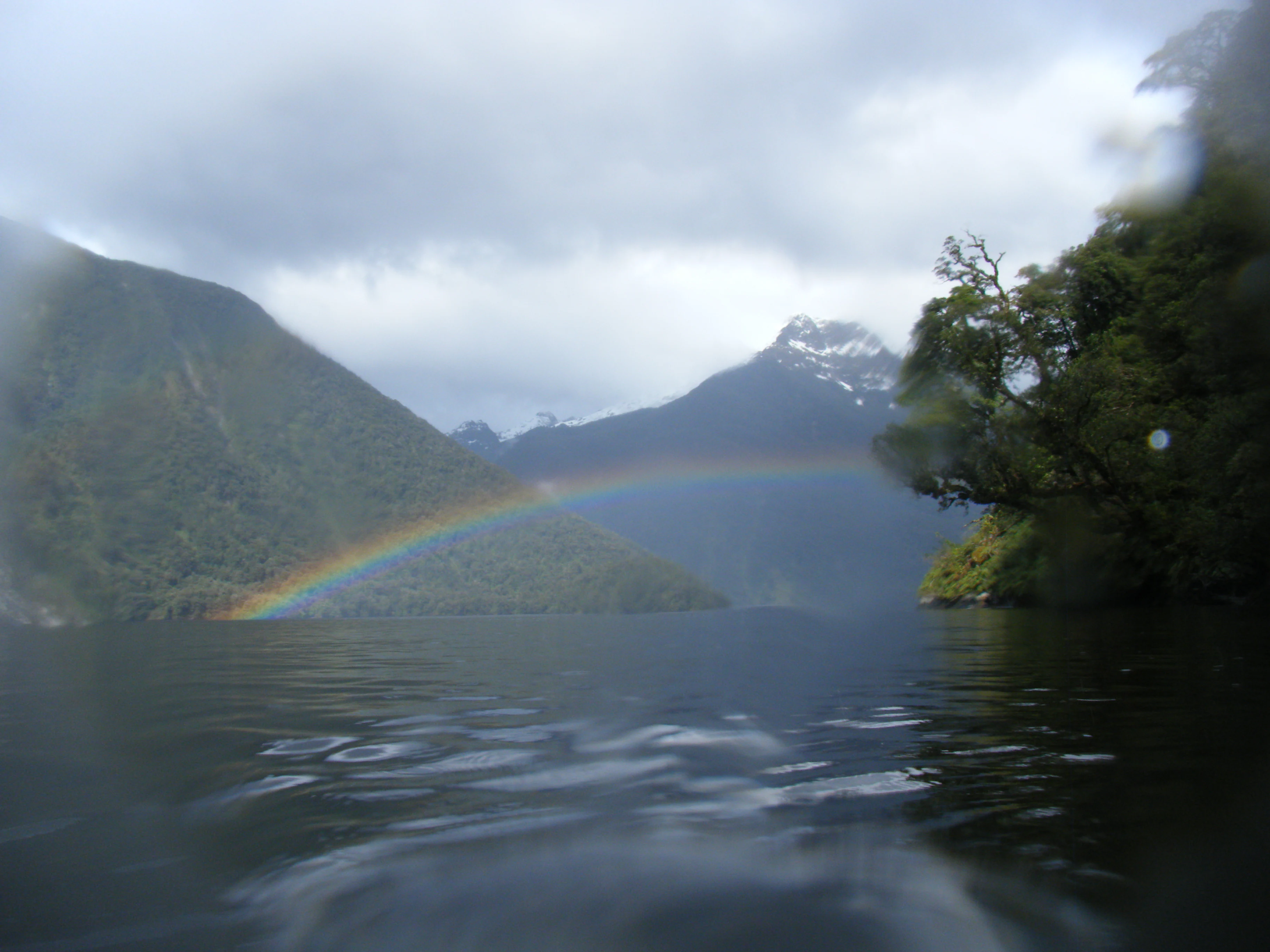
A low-angle view from the water looking toward a rainbow spanning across a quiet fiord, surrounded by steep, lush green, mountain slopes under a cloudy sky.
A rainbow stretches across the calm waters of the fiord, framed by steep, forested mountains.

Kutu Parera (Gaer Arm) Marine Reserve history and protected-area timeline

The history of Kutu Parera (Gaer Arm) Marine Reserve begins well before its formal protection. The Māori name Kutu Parera, also recalled as Hāwea, references the ancient iwi of Kāti Hāwea, an early hapu whose identity and ancestral connections are tied to this stretch of Fiordland coast. This cultural heritage continues to shape the reserve's governance and customary arrangements.

The modern reserve emerged from a regional conservation effort rather than a top-down designation. In 2002, the Fiordland Marine Guardians, a community-based conservation body, launched a broader marine protection strategy for the Fiordland coast. This was presented to the Minister for the Environment Marian Hobbs and the Minister of Fisheries Pete Hodgson in 2003, building political and community support for new marine reserves within the Doubtful Sound and Bradshaw Sound systems.

Following this advocacy, Kutu Parera (Gaer Arm) Marine Reserve was officially established on 21 April 2005, becoming part of the expanding network of strictly protected marine areas around Fiordland. Since then, agencies including the Ministry of Primary Industries and the Fiordland Marine Guardians have worked together to monitor the reserve and to address emerging threats such as the spread of invasive seaweed. By 2021, the New Zealand Air Force was conducting aerial surveillance patrols to detect illegal commercial fishing activity in the area, reflecting the ongoing importance of enforcement to maintain the reserve's integrity.

Kutu Parera (Gaer Arm) Marine Reserve landscape and geographic character

The landscape of Kutu Parera (Gaer Arm) Marine Reserve is defined by the vertical, mountain-flanked character of Fiordland itself. Gaer Arm is a steep-sided inlet branching off Bradshaw Sound, surrounded by forested slopes that rise sharply from the shoreline, creating the dramatic enclosed seafjord setting for which the region is internationally known. The reserve's 433 hectares sit within this confined, sheltered coastal environment.

Above and around the waterline, the reserve is framed by the high-relief terrain of the Fiordland mountains, whose catchments channel rainwater and forest-derived organic material directly into the sea. At the surface, the freshwater layer that sits atop the saltwater reflects this landscape setting: a thin, slightly darker lens that can range from just a few centimetres thick to as much as ten metres in some places, drifting across the more permanent seawater layers below.

The underwater landscape is equally distinctive. Near the river mouth and inside the arm, the seafloor includes a shallow basin and sediment fan sourced from the Camelot River, transitioning through seagrass flats and into reef structures. The eastern side of Gaer Arm is dominated by an extensive rock wall that plunges vertically by around 59 to 60 metres, mostly facing south and shaded from direct sunlight, while the western side features broken reef habitat with submerged boulders and areas shaped by river overflow. Together these features create a varied underwater topography compressed into a relatively small marine reserve footprint.

Kutu Parera (Gaer Arm) Marine Reserve ecosystems, habitats, and plant life

Kutu Parera (Gaer Arm) Marine Reserve sits within one of the world's most unusual marine ecological settings, where fiord topography combines with intense freshwater input to create a layered aquatic environment. The freshwater cap at the surface, sourced from heavy mountain runoff, overlies a clearer and warmer seawater layer that hosts a wide range of marine organisms. Deeper still lies a dark, tannin-stained layer that is largely inhospitable to most marine life.

This stratification, combined with the protected status of the reserve, supports a rich mosaic of habitats in close proximity. The Camelot River estuary and the shallow basin near the head of the arm contain soft sediment areas, seagrass flats, and tidal inputs from the river system. Toward the mouth of Gaer Arm, the seafloor drops to around 100 metres, while the eastern rock wall and the broken western reef create structurally complex environments supporting diverse invertebrate and fish communities.

Vegetation patterns in and around the reserve reflect the same mixing of marine and freshwater influences. Seagrass beds anchor soft sediments in shallow zones, while the steep slopes beside the sound remain cloaked in dense temperate rainforest whose organic matter continually alters the chemistry and light penetration of the underlying seawater.

Kutu Parera (Gaer Arm) Marine Reserve wildlife and species highlights

The wildlife of Kutu Parera (Gaer Arm) Marine Reserve reflects its role as a sheltered Fiordland inlet within the wider Doubtful Sound ecosystem. Invertebrates are a defining feature of the reserve's biological communities, with extensive populations of sponges and corals occupying the clearer middle layer of the water column and thriving on the shaded eastern rock wall. That wall, in particular, supports many sea anemones and other sessile suspension feeders that benefit from the cool, stable, low-light conditions.

Fish life in the reserve is tied closely to the habitats found within the arm. Shallow basin areas contain some of the largest known populations of cockles and pipi within Doubtful Sound, providing a productive food source for reef-associated fish such as grouper and tarakihi that hunt around the broken reef and rocky outcrops. Seagrass flats add habitat complexity, supporting smaller fish and invertebrate prey species.

The reserve also hosts marine mammals. Bottlenose dolphins (called aihe in te reo Māori) are known to use the area, and management rules are specifically designed to minimize the impact of vessel activity on them. The wider Fiordland ecosystem surrounding the reserve supports additional marine mammal life, and the protected status ensures these species can pass through and forage in the reserve with reduced disturbance from fishing and extraction.

Kutu Parera (Gaer Arm) Marine Reserve conservation status and protection priorities

Conservation is the core purpose of Kutu Parera (Gaer Arm) Marine Reserve. Established as a strictly protected area under New Zealand's marine reserves framework, it prohibits fishing and the taking, killing, or moving of marine life and materials, creating a baseline of minimal human impact in a region where such protection is critical to maintaining biodiversity.

The reserve's conservation significance is amplified by its location within Fiordland, where steep topography and remote access already limit many pressures seen in other coastal areas. By protecting the layered fiord water column, its estuarine habitats, seagrass flats, and reef walls, the reserve contributes to the long-term resilience of the Doubtful Sound and Bradshaw Sound marine ecosystems, including the population dynamics of locally important shellfish such as cockles and pipi.

Conservation management is a collaborative effort. The Department of Conservation administers the reserve, while the Ministry of Primary Industries, the Fiordland Marine Guardians, and other agencies work together to monitor ecological health, respond to threats such as invasive seaweed, and enforce protection rules. Air Force aerial surveillance patrols have been deployed to deter illegal commercial fishing. The reserve also accommodates customary practices, allowing Ngāi Tahu to collect pounamu and certain marine mammal remains under specific cultural protocols that minimize environmental disturbance.

Kutu Parera (Gaer Arm) Marine Reserve cultural meaning and human context

The cultural identity of Kutu Parera (Gaer Arm) Marine Reserve is inseparably linked to the Māori heritage of Fiordland. The name 'Kutu Parera' is drawn from Māori language, and the area has also historically been known as Hāwea, referencing the ancient iwi of Kāti Hāwea whose ancestral presence shaped the place long before formal conservation designations.

The reserve is located within the rohe of Ngāi Tahu, the principal iwi of the southern South Island today. Customary rights are formally integrated into reserve management: Ngāi Tahu members with appropriate authorization may collect pounamu by hand, subject to strict limits on disturbance and on the quantity taken in a single trip. They may also collect deceased marine mammals and gather teeth and bones, reflecting a continuity of cultural practice and relationship with this coastal environment.

The role of the Fiordland Marine Guardians in advocating for the reserve's creation is itself an important expression of local community and cultural identity. As a community-based conservation body, the Guardians drew on both ecological knowledge and place-based cultural understanding to argue for marine protection in Fiordland, contributing to the broader narrative of how residents and iwi have worked together to safeguard this iconic part of New Zealand.

Top sights and standout views in Kutu Parera (Gaer Arm) Marine Reserve

A standout feature of Kutu Parera (Gaer Arm) Marine Reserve is its stratified fiord water column, in which a thin freshwater layer, a productive clear-water layer, and a deep tannin-stained layer create distinct ecological zones within a compact marine area. Few marine reserves in New Zealand display this layering so clearly, and it underpins much of the reserve's biodiversity.

The reserve also features a dramatic 59 to 60 metre south-facing rock wall on the eastern side of Gaer Arm, a rare shaded underwater cliff that supports rich communities of sea anemones and sessile suspension feeders. Together with the shallow basin, seagrass flats, and broken reef on the western side, the reserve compresses an unusually diverse range of marine habitats into just 433 hectares.

Finally, the integration of strong legal protection, active community stewardship through the Fiordland Marine Guardians, Ngāi Tahu customary harvest rights for pounamu, and targeted enforcement action such as aerial surveillance gives the reserve a notable combination of protected status and active management that reinforces both its ecological and cultural importance.

Best time to visit Kutu Parera (Gaer Arm) Marine Reserve

The character of a visit to Kutu Parera (Gaer Arm) Marine Reserve is closely tied to Fiordland's climate and the behavior of its marine life. The region receives heavy rainfall year-round, which sustains the layered water column that defines the reserve. Visiting during the calmer and generally drier months of the New Zealand summer, from late December to February, often provides more accessible conditions for boat-based exploration, snorkeling, and diving, especially for those traveling via Te Anau and the Milford Road.

Winter and early spring bring cooler temperatures, more frequent rain, and occasional storms, but they can also offer quieter conditions and a different atmospheric quality along the steep forested shores of Gaer Arm. Divers and snorkelers may encounter different visibility conditions at this time, though the reserve's protected status ensures that the marine communities remain undisturbed regardless of season.
Monthly climate preview

Long-term representative temperature and precipitation averages recorded across twelve months

Kutu Parera (Gaer Arm) Marine Reserve Climate Normals and Annual Weather Patterns

Representative coordinates document sustained thermal variation alongside consistent daily precipitation throughout the annual cycle at Kutu Parera (Gaer Arm) Marine Reserve. Detailed monthly profiles provide complete comparative data for analyzing long-term climate normals across the protected area.
Annual mean9 °C
5 °C12 °C
Jan12°
Feb12°
Mar11°
Apr
May
Jun
Jul
Aug
Sep
Oct
Nov
Dec11°
Warmest month
February

12.2 °C

Coolest month
July

5.1 °C

Wettest month
October

8.6 mm/day

Driest month
July

6.6 mm/day

Park location guide

Geography guide, regional context, and park location map for Kutu Parera (Gaer Arm) Marine Reserve

Kutu Parera (Gaer Arm) Marine Reserve park geography, regions, and map view in New Zealand

Understand where Kutu Parera (Gaer Arm) Marine Reserve sits in New Zealand through a broader geographic reading of the surrounding landscape, nearby location context, and its mapped position within the national park landscape.

How Kutu Parera (Gaer Arm) Marine Reserve fits into New Zealand

New Zealand is an island nation in the southwestern Pacific Ocean comprising two main islands and numerous smaller islands. Located east of Australia across the Tasman Sea, it features varied topography with the Southern Alps running along the South Island and volcanic terrain on the North Island. The country was settled by Maori people between 1280 and 1350, followed by European exploration beginning in 1642, and became a Dominion in 1907 before gaining full independence in 1947.

Wider geography shaping Kutu Parera (Gaer Arm) Marine Reserve in New Zealand

New Zealand lies in the southwestern Pacific Ocean, east of Australia across the Tasman Sea. The country consists of two main islands, the North Island and South Island, plus over 600 smaller islands. The North Island features volcanic plateaus and hills while the South Island is dominated by the Southern Alps mountain range. The country has a long coastline and is surrounded by the Pacific Ocean.

Map view of Kutu Parera (Gaer Arm) Marine Reserve

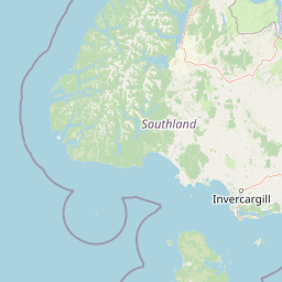
Use this park location map to pinpoint Kutu Parera (Gaer Arm) Marine Reserve in New Zealand, understand its exact geographic position, and read its mapped placement within the surrounding landscape more clearly.

Pigeon | © OpenStreetMap contributors

Location context for Kutu Parera (Gaer Arm) Marine Reserve

Fiordland
Natural feature types

View the Natural Landscape Atlas for Kutu Parera (Gaer Arm) Marine Reserve

Examine the detailed physical topography and marine landmarks located within Kutu Parera (Gaer Arm) Marine Reserve. MoriAtlas provides a comprehensive breakdown of the stratified underwater layers and coastal features that define this critical section of New Zealand's Fiordland coastline.
Recorded earthquake history

Explore the Historical Earthquake Records for Kutu Parera (Gaer Arm) Marine Reserve

Access a structured collection of recorded seismic activity associated with the Kutu Parera (Gaer Arm) Marine Reserve geography. This MoriAtlas resource allows for the focused review of historical event data, providing geographic context for this unique Fiordland protected area.

Kutu Parera (Gaer Arm) Marine Reserve Earthquake History

Catalogued events

528 events

Strongest magnitude

Magnitude 7.2

Most recent event

Aug 1, 2026

This history includes earthquakes recorded inside the park or within 50 km of its borders

Visual exploration of steep-walled fiords, vertical rock walls, and marine habitats

Kutu Parera (Gaer Arm) Marine Reserve Photos, Landscapes, and Scenery

Photographic collection reveals the dramatic landscape and stratified underwater environments of Kutu Parera (Gaer Arm) Marine Reserve. Visual documentation illustrates the protected coastal terrain, steep mountain slopes, and diverse marine habitats of the Fiordland region.

A low-angle view from the water looking toward a rainbow spanning across a quiet fiord, surrounded by steep, lush green, mountain slopes under a cloudy sky.

Park atlas

Discover adjacent marine reserves and regional protected landscapes across the South Island

Explore Protected Areas and Parks Near Kutu Parera (Gaer Arm) Marine Reserve

Compare Kutu Parera (Gaer Arm) Marine Reserve with neighboring coastal habitats, fiord ecosystems, and regional protected areas. Expanding the geographic scope reveals broader patterns of marine conservation and rugged mountain terrain across the surrounding region.
National parkSouthland Region
Park boundaries overlap#1 closest

East

Fiordland National Park: A Protected Landscape of Glacier-Carved Fiords and Alpine Wilderness

Explore its vast boundaries and unique temperate rainforest.

Fiordland National Park, located in the Southland Region of New Zealand, is a testament to dramatic geological forces, featuring fifteen major fiords like Milford Sound, whose Mitre Peak rises majestically from the water. This protected national park encompasses an immense wilderness of alpine terrain, ancient beech forests, and numerous waterfalls, fueled by exceptional rainfall. Its inclusion in the Te Wāhipounamu World Heritage Area underscores its global significance for biodiversity and natural landscape preservation.

Area
12,607 km²
Established
1952
IUCN
II
Visitors
500K annual
Marine protected areaFiordland
10 km away#2 closest

South

Taipari Roa (Elizabeth Island) Marine Reserve: Fiordland Marine Landscape and Atlas Map

Protected marine terrain and glacial fjord geography

Taipari Roa (Elizabeth Island) Marine Reserve is a protected marine area situated within the complex fjord network of Doubtful Sound. The reserve is characterized by steep underwater rock walls, deep kelp forests, and a unique freshwater cap that allows rare corals and glass sponges to thrive at shallow depths. This geographic overview examines the reserve's protected status and its structural role within the broader Fiordland ecosystem, highlighting the vertical aquatic terrain and surrounding islet environments.

Area
6.13 km²
Established
2005
Relief
Lowland
Climate
Temperate
Marine protected areaFiordland
14 km away#3 closest

North

Kahukura (Gold Arm) Marine Reserve: Marine Protected Area and Fiordland Geographic Atlas

Submerged rocky reefs and vertical rock wall landscapes

Located in the heart of New Zealand, Kahukura (Gold Arm) Marine Reserve provides a vital map of protected coastal terrain. Its unique environment features freshwater caps, tannin-stained deep water, and diverse marine topography ranging from sheltered basin ecosystems to vertical cliff structures. This marine area offers deep insight into the complex geology and conservation dynamics of the Fiordland region.

Area
4.64 km²
Established
2005
Relief
Mixed relief
Climate
Temperate
Marine protected areaFiordland
35 km away#4 closest

Southwest

Moana Uta (Wet Jacket Arm) Marine Reserve: Mapped Protected Landscapes in Fiordland

Exploring unique fiord stratification and dense marine coral habitats

Located in the remote southwestern reaches of New Zealand, Moana Uta (Wet Jacket Arm) Marine Reserve preserves a complete fiord system. The area is notable for its exceptional physical conditions, including high black coral density and a distinct freshwater surface layer that sustains diverse underwater communities across steep rock walls, reefs, and deep basins.

Area
20.07 km²
Established
2005
Relief
Lowland
Climate
Temperate
Marine protected areaFiordland
58 km away#5 closest

Northeast

Hawea (Clio Rocks) Marine Reserve: Protected Marine Geography in Fiordland, New Zealand

Mapping vertical rock walls and stratified fiord water ecosystems.

Hawea (Clio Rocks) Marine Reserve is an ecologically significant marine protected area situated within the deep waters of Hāwea / Bligh Sound. The reserve is defined by its dramatic vertical rock walls, tidal current channels, and the complex water stratification that sustains diverse black coral and reef communities. It offers a unique window into the geological and marine processes that have shaped the rugged coastal landscape of New Zealand's Fiordland.

Area
4.11 km²
Established
2005
IUCN
Ia
Relief
Mountain
A soft watercolor painting depicting a calm shoreline with rolling hills in the background under a pale sky.
Marine protected areaFiordland
91 km away#6 closest

Northeast

Piopiotahi (Milford Sound) Marine Reserve: Mapped Protected Area and Fiord Geography

A signature marine landscape within New Zealand's Fiordland region.

Piopiotahi (Milford Sound) Marine Reserve protects a distinct underwater environment characterized by dramatic vertical rock walls and deep basins. By examining the geographic boundaries and oceanographic layering of this Fiordland site, users can better understand the interplay between the steep forested cliffs above and the thriving coral and marine wildlife habitats below the surface.

Area
6.9 km²
Established
1993
Relief
Mountain
Climate
Temperate
National parkOtago
100 km away#7 closest

Northeast

Mount Aspiring National Park: Glaciated Alpine Wilderness & Protected Landscape Atlas

Explore the U-shaped valleys and mapped boundaries of this iconic national park.

Mount Aspiring National Park showcases a breathtaking glacial landscape defined by steep-sided U-shaped valleys, active glaciers, and soaring alpine summits. As a designated national park within New Zealand's South Island, its protected status preserves a vast area of wilderness crucial for understanding regional geography and alpine terrain. This page provides an atlas-style exploration of its mapped boundaries and the stark, natural beauty that characterizes this significant conservation landscape in the Otago region.

Area
3,562 km²
Established
1964
IUCN
II
Relief
Mountain
National parkNew Zealand
159 km away#8 closest

South

Rakiura National Park: New Zealand's Remote Protected Wilderness & Landscape Atlas

Explore its rugged terrain and unique subantarctic ecosystem.

Rakiura National Park encompasses the majority of Stewart Island, offering a unique glimpse into one of New Zealand's most remote and undisturbed natural environments. This protected landscape features rugged forested hills, extensive coastlines with isolated beaches, and is globally recognized for its abundant kiwi populations. Discover the park's geographic setting and its significance as a protected area for both wildlife and cultural heritage within the broader atlas of New Zealand's natural wonders.

Area
1,399.6 km²
Established
2002
IUCN
II
Relief
Lowland

Common questions about visiting, size, designation, and location context for Kutu Parera (Gaer Arm) Marine Reserve

Kutu Parera (Gaer Arm) Marine Reserve FAQs for park facts, access, geography, and protected area context

Find quick answers about Kutu Parera (Gaer Arm) Marine Reserve, including protected-area facts, park geography, trail and visitor context, and how the park fits into its surrounding country and regional landscape.
MoriAtlas Explorer

Continue Your Protected Areas Search Across the Global Atlas

Deepen your exploration by continuing the structured search for national parks and protected areas worldwide. Utilize the comprehensive filtering capabilities to compare different conservation landscapes and refine your understanding of global park geography. Discover more about the distribution and characteristics of protected natural areas.

Global natural geography