

Mori Atlas logo
National parkLa Caleta Underwater National Park

Discover the mapped underwater terrain and protected boundaries of this Dominican Republic national park.

La Caleta Underwater National Park: Protected Marine Landscape and Geographic Context in Dominican Republic

(Parque Nacional Submarino La Caleta)

La Caleta Underwater National Park represents a distinct protected marine environment within the Dominican Republic. This page serves as the definitive atlas entry for understanding its geographic scope, protected area status, and mapped underwater landscapes. Explore how this national park contributes to the regional geography and conservation efforts of Hispaniola Island.

Marine National ParkCoral Reef DivingCaribbean Protected AreaArchaeological SiteEcotourism DestinationPre-Columbian Heritage

La Caleta Underwater National Park

National park

Park overview

Structured park overview, official facts, and landscape profile for La Caleta Underwater National Park

La Caleta Underwater National Park park facts, protected area profile, and essential visitor context

Review the core facts for La Caleta Underwater National Park, including designation, size, terrain, visitor scale, habitats, and operating context in one park-focused overview.

About La Caleta Underwater National Park

La Caleta Underwater National Park represents a distinctive fusion of marine conservation and archaeological preservation along the southern coast of the Dominican Republic. The park sits approximately 20 kilometers west of Santo Domingo in Santo Domingo Province, adjacent to Las Americas International Airport, positioning it as a convenient destination for both international visitors arriving through the capital and domestic tourists. Established in 1986, it holds the distinction of being the first underwater national park in the Dominican Republic and remains the country's only marine national park. The park functions as an ecotourism destination focused on assessing natural resources while promoting conservation awareness and respect for marine environments among visitors. Its accessibility, combined with the remarkable clarity of its Caribbean waters and the dramatic underwater topography created by coral formations and the sunken Hickory vessel, draws divers from throughout the Dominican Republic and internationally. The park's dual character extends beyond its marine environments to encompass significant terrestrial archaeological resources, making it a comprehensive cultural and natural heritage site.

Quick facts and research context for La Caleta Underwater National Park

La Caleta Underwater National Park is located in Santo Domingo Province, Dominican Republic, roughly 20 kilometers from the capital city and adjacent to Las Americas International Airport. Created on September 25, 1986 through Decree No. 249, it was the Dominican Republic's first underwater protected area. The 12-square-kilometer park features coral reefs at depths between 10 and 50 meters, with the deepest waters reaching 180 meters. The park houses both an underwater diving attraction (the intentionally sunk vessel Hickory) and an on-shore Ethnological and Archaeological Museum containing Taíno artifacts. Management is shared between Reef Check Dominican Republic and local community partners, representing a community-based coastal marine management model for the country.

Protection and recognition

Verifying the marine boundary status and official designation records.

Official Protected Area Status of La Caleta Underwater National Park

International conservation databases record the official marine protection scope and official designation parameters for La Caleta Underwater National Park. Comparing verified administrative records offers clear insight into managed boundaries and the legal framework protecting crucial marine environments.

Protection details

Protection scope
Marine
Park context

Deeper park guide and search-rich context for La Caleta Underwater National Park

La Caleta Underwater National Park history, landscape, wildlife, and travel context

Explore La Caleta Underwater National Park through its history, landscape character, ecosystems, wildlife, conservation priorities, cultural context, and seasonal travel timing in a structured park guide built for atlas discovery and search intent.

Why La Caleta Underwater National Park stands out

La Caleta Underwater National Park is best known for its exceptional coral reef diving, consistently ranked among the top five diving destinations in the Caribbean. The park's defining underwater feature is the intentionally sunk vessel Hickory, which now serves as an artificial reef habitat attracting diverse reef fish populations. The park also holds exceptional archaeological significance for its pre-Columbian burial site, where archaeologists discovered 373 skeletons of indigenous people in 1972, representing Ostionoid, Late Taíno, and Late Elenoide cultural components dating to AD 650, 750, and 840. This dual nature, combining world-class diving with significant archaeological heritage, makes La Caleta uniquely distinguished among Caribbean marine protected areas.

La Caleta Underwater National Park history and protected-area timeline

The history of La Caleta spans pre-Columbian times through modern marine conservation. When Spanish conquistadors arrived in 1492, the area was known as Herds led Toto and served as a major indigenous settlement engaged in fishing and agriculture, home to the Taíno people who had inhabited Hispaniola for centuries. The modern park's origins began in 1972 when families living around the small beach were relocated to allow excavation for what would become the Pantheon Archaeological Museum and the establishment of the national park. That same year, archaeologists discovered 373 skeletons of pre-Columbian people in a burial mound, a finding of extraordinary importance because the remains represented three cultural components that had inhabited the island: Ostionoid, Late Taíno, and Late Elenoide. Radiocarbon dating placed the remains at AD 650, 750, and 840. A second burial mound contained a child's remains suggesting ritual practices. The excavation, conducted over two years by archaeologists Morban Laucer Fernando, Luis Chanlatte Baik, and Manuel Garcia Arevalo under Dominican government auspices with researchers from the United States and Puerto Rico, led to the opening of the La Caleta Centre and Archaeological Museum in 1974 under President Joaquín Balaguer. The park itself was formally established in 1986, with the Hickory vessel intentionally sunk in 1984 to create an artificial reef and diving attraction.

La Caleta Underwater National Park landscape and geographic character

La Caleta Underwater National Park encompasses a coastal and offshore marine landscape characterized by well-developed coral reef formations along the southern Dominican Republic coast. The park's underwater terrain features coral reefs spanning depths from approximately 10 meters to 50 meters, with the deepest waters reaching 180 meters. The reef formations create a varied underwater topography including coral ridges, valleys, and slope areas that support diverse marine ecosystems. The park's location near Santo Domingo places it along a stretch of coastline that has historically been significant for settlement, with the adjacent terrestrial area containing the archaeological museum and former burial sites. The landscape combines the underwater reef environment with coastal facilities including the museum, beach areas, and access points typical of marine protected areas designed for both recreation and education. The proximity to Las Americas International Airport defines the park's accessibility and establishes its role as a destination immediately accessible to international travelers arriving in the Dominican Republic.

La Caleta Underwater National Park ecosystems, habitats, and plant life

The nature of La Caleta centers on its thriving coral reef ecosystems within the Caribbean marine environment. The park protects extensive coral reef formations between 10 and 50 meters depth, representing some of the most developed reef structures along the Dominican coast. These coral communities support diverse marine life typical of Caribbean reef systems, providing habitat, feeding grounds, and shelter for numerous fish species and invertebrates. The intentionally sunk vessel Hickory has become an artificial reef, creating additional habitat structure and attracting congregations of reef fish. The park's classification as an ecotourism destination emphasizes assessment of natural resources while educating visitors about marine conservation. The coral reef ecosystem functions as the ecological foundation for the park's significance, both for its biodiversity value and its role as a diving attraction that supports the park's tourism and conservation objectives.

La Caleta Underwater National Park wildlife and species highlights

The wildlife of La Caleta Underwater National Park centers on coral reef-associated marine species within the Caribbean ecosystem. The park's coral reefs between 10 and 50 meters depth support diverse fish communities that have colonized both natural reef formations and the artificial reef created by the sunken Hickory vessel. The reef structures provide critical habitat for numerous reef fish species, invertebrates, and other marine organisms that depend on healthy coral communities. The park's designation as a diving destination depends on the visibility and health of these reef communities, which attract divers seeking encounters with Caribbean marine life. While the source material emphasizes the reef environment and fish habitat rather than listing specific species, the underwater park clearly supports populations of reef fish and other marine organisms that inhabit the coral formations throughout the protected area.

La Caleta Underwater National Park conservation status and protection priorities

La Caleta Underwater National Park holds significant conservation importance as the only marine national park in the Dominican Republic and as a model for community-based coastal marine management. The park was established to protect exceptional coral reef ecosystems that rank among the best in the Caribbean, representing marine biodiversity of national and regional significance. The reef systems between 10 and 50 meters depth require protection from pressures including coastal development, pollution, and overfishing that threaten Caribbean marine environments. Recent management evolution has positioned La Caleta as a national model: the government awarded co-management responsibility to Reef Check Dominican Republic and local community partners, creating a collaborative approach that empowers local communities to sustainably manage coastal ecosystems while benefiting from their resources. This community-based management model aims to expand to other marine protected areas in the Dominican Republic, aligning local priorities with conservation goals. The park's dual archaeological and marine conservation significance adds another dimension to its protection value.

La Caleta Underwater National Park cultural meaning and human context

The cultural context of La Caleta Underwater National Park extends from pre-Columbian indigenous heritage to modern marine recreation. Before European contact, the area was a significant Taíno settlement known as Herds led Toto, where indigenous people practiced fishing and agriculture. The 1972 archaeological discovery of 373 pre-Columbian skeletons revealed the site's exceptional importance, with remains representing three cultural components that inhabited Hispaniola: Ostionoid, Late Taíno, and Late Elenoide. These findings, dating to AD 650, 750, and 840, illuminate the pre-Columbian history of the island and the burial practices of its indigenous peoples. The resulting Archaeological Museum preserves and displays artifacts and remains for educational purposes, providing visitors with insight into the island's indigenous heritage. This archaeological dimension complements the park's marine environment, creating a cultural landscape where pre-Columbian history and Caribbean marine ecology intersect.

Top sights and standout views in La Caleta Underwater National Park

The highlights of La Caleta Underwater National Park include its ranking among the top five diving destinations in the Caribbean, featuring coral reefs between 10 and 50 meters depth and maximum depths of 180 meters. The intentionally sunk vessel Hickory serves as the park's signature underwater attraction, functioning as an artificial reef that supports diverse reef fish populations. The Ethnological and Archaeological Museum preserves pre-Columbian artifacts and the remains of 373 indigenous individuals representing Ostionoid, Late Taíno, and Late Elenoide cultures dating to the 7th through 9th centuries AD. As the first underwater national park in the Dominican Republic and the country's only marine national park, La Caleta represents a pioneering conservation model now being replicated through community-based management partnerships with Reef Check Dominican Republic. The park's accessibility, located 20 kilometers from Santo Domingo and adjacent to the international airport, makes it one of the most visited protected areas in the country.

Best time to visit La Caleta Underwater National Park

La Caleta Underwater National Park can be visited year-round given its location in the Caribbean, where warm temperatures and diving conditions persist throughout the seasons. The park's marine environment benefits from the consistent tropical climate of the Dominican Republic, though the best diving conditions typically correspond with the drier months from December through April when visibility tends to be most favorable. The summer months from May through November bring warmer water temperatures and the possibility of increased rainfall, though diving remains viable. The park's proximity to Santo Domingo and Las Americas International Airport makes it accessible for day trips or short visits regardless of season. Visitors interested in the archaeological museum should note that the on-shore facilities operate independently of diving conditions, though combining underwater and archaeological experiences in a single visit provides the most complete picture of the park's dual heritage.
Monthly climate preview

Long term monthly temperature and precipitation rhythm for La Caleta Underwater National Park

La Caleta Underwater National Park Climate and Temperature Normals Preview

Representative coordinate records show average monthly temperatures ranging from 25.21 to 28.4 degrees Celsius alongside varying daily precipitation rates across the year. Reviewing the complete twelve month climate profile provides deeper insight into measured long term weather patterns.
Annual mean27 °C
25 °C28 °C
Jan25°
Feb26°
Mar26°
Apr27°
May28°
Jun28°
Jul28°
Aug28°
Sep28°
Oct28°
Nov27°
Dec26°
Warmest month
August

28.4 °C

Coolest month
January

25.2 °C

Wettest month
November

2.4 mm/day

Driest month
March

0.8 mm/day

Park location guide

Geography guide, regional context, and park location map for La Caleta Underwater National Park

La Caleta Underwater National Park park geography, regions, and map view in Dominican Republic

Understand where La Caleta Underwater National Park sits in Dominican Republic through a broader geographic reading of the surrounding landscape, nearby location context, and its mapped position within the national park landscape.

How La Caleta Underwater National Park fits into Dominican Republic

The Dominican Republic is a presidential republic on Hispaniola island in the Caribbean. It occupies the eastern portion of the island, sharing the western part with Haiti. The country has a population of approximately 11.5 million and is known for its colonial history, beaches, and mountainous interior. Santo Domingo is the capital and largest city.

Wider geography shaping La Caleta Underwater National Park in Dominican Republic

The Dominican Republic occupies the eastern five-eighths of Hispaniola island in the Greater Antilles, bordered by the Caribbean Sea. It shares a land border with Haiti to the west and has maritime boundaries with Puerto Rico to the east. The terrain features mountainous interior ranges, fertile valleys, and coastal plains. The country is second in size among Caribbean nations after Cuba.

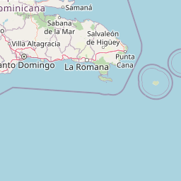
Map view of La Caleta Underwater National Park

Use this park location map to pinpoint La Caleta Underwater National Park in Dominican Republic, understand its exact geographic position, and read its mapped placement within the surrounding landscape more clearly.

Pigeon | © OpenStreetMap contributors
Park atlas

Map surrounding marine and terrestrial protected areas to trace the regional conservation geography of the Caribbean.

Explore Dominican Republic's Protected Areas Near La Caleta Underwater National Park

Continue your exploration from La Caleta Underwater National Park by browsing other national parks and protected areas across the Dominican Republic, including marine reserves and diverse terrestrial landscapes. This geographic overview helps compare conservation efforts, understand regional park distribution, and discover adjacent protected-area features for comprehensive atlas discovery.
National parkDominican Republic
About 17 km away#1 closest

West

The Three Eyes National Park: Dominican Republic National Park Geography and Atlas Context

Mapped protected landscapes and natural terrain within Hispaniola.

Delve into the protected area details of The Three Eyes National Park, a designated national park situated in the Dominican Republic. This page facilitates a structured discovery of its geographic scope, mapped boundaries, and the surrounding natural landscapes, offering essential context for anyone exploring the atlas of protected areas within Hispaniola. Understand its unique character as a key element of the country's conservation geography.

IUCN
II
Relief
Lowland
Climate
Tropical
Access
Easy access
National parkDominican Republic
About 50 km away#2 closest

North

Los Haitises National Park: Dominican Republic Protected Landscape & Park Geography

Mapped terrain and protected area boundaries in the Dominican Republic.

Los Haitises National Park is a vital protected national park in the Dominican Republic, offering unique insights into the region's geography and natural landscapes. This page delves into its mapped boundaries, regional context, and the importance of its protected status for understanding Dominican Republic's conservation areas. Gain a structured view of this important natural landscape and its place within a broader geographic atlas.

Area
826 km²
Established
1976
IUCN
II
Relief
Upland
National parkDominican Republic
About 56 km away#3 closest

East

Cueva de las Maravillas National Park: Dominican Republic National Park Protected Landscape and Geography

Explore the mapped features and natural terrain of this Dominican national park.

Cueva de las Maravillas National Park is a key protected entity within the Dominican Republic, offering rich geographic context for atlas exploration. This entry focuses on the park's identity as a national park, detailing its mapped boundaries and natural landscape features. Understand its specific role within the Dominican Republic's broader geography and its significance as a conservation area, providing essential context for landscape discovery.

Area
4.5 km²
Established
1997
IUCN
II
Relief
Lowland
National parkDominican Republic
About 89 km away#4 closest

West

Valle Nuevo National Park: Nearctic Highland Ecosystem and Glacial Landscapes

Mapped protected area in the Dominican Republic's Cordillera Central.

Valle Nuevo National Park in the Dominican Republic offers a rare glimpse into a Nearctic ecosystem within the Caribbean. Spanning 910 square kilometers in the Cordillera Central, it features dramatic mountain peaks like Loma Alto de la Bandera and distinctive glacial landforms. The park protects extensive Hispaniolan pine forests and cloud forest habitats, supporting remarkable endemic biodiversity and serving as a critical watershed for the region.

Area
910 km²
Established
1996
IUCN
II
Relief
Mountain
National parkDominican Republic
About 106 km away#5 closest

East

Cotubanamá National Park: Dominican Republic National Park Geography and Protected Landscape

Explore the mapped terrain and natural boundaries.

Cotubanamá National Park stands as a vital component of the Dominican Republic's protected lands. This entry provides detailed atlas-style information, focusing on the park's geographic context, its designation as a national park, and the specific character of its protected landscape. Understand its role within the broader Caribbean geography and the mapped natural features that define this significant area.

Area
792 km²
Established
1975
IUCN
II
Visitors
728K annual
National parkDominican Republic
About 130 km away#6 closest

Northwest

Pueblo Viejo National Park: Dominican Republic Colonial Ruins and Gold Mining Heritage

Explore early Caribbean colonization and its archaeological landscape.

Pueblo Viejo National Park stands as a crucial archaeological site in the Dominican Republic, preserving the remnants of Concepción de la Vega, a significant colonial settlement established during the era of Christopher Columbus. This national park offers a unique window into the beginnings of European presence and the first major gold extraction operations in the Americas. Examine the mapped foundations of its fortress and town structures, understanding the colonial urban planning and the historical geography of early Caribbean heritage.

IUCN
II
Access
Easy access
Scope
Terrestrial
Water
No major water
National parkDominican Republic
About 139 km away#7 closest

Northwest

José Armando Bermúdez National Park: Dominican Republic National Park Atlas and Landscape Context

Discover the mapped protected area and geographic setting of this Dominican Republic national park.

Gain an understanding of José Armando Bermúdez National Park as a distinct protected landscape within the Dominican Republic. This entry focuses on its role as a national park, providing geographic context and highlighting its mapped boundaries for atlas exploration. Explore the park's specific terrain and its place within the nation's conservation network.

Area
766 km²
Established
1956
IUCN
II
Relief
Mountain
National parkIndependencia Province
About 179 km away#8 closest

West

La Gran Sabana National Park: National Park Identity and Geographic Mapping

Exploring protected landscapes and regional context.

This detail entry focuses on La Gran Sabana National Park, delineating its identity as a protected national park within Independencia Province. It provides essential context for understanding the park's mapped boundaries, its specific geographic setting, and its role within the natural landscape. Users can explore its atlas-relevant features and understand its place in the broader geography of the Dominican Republic.

Area
219.58 km²
Established
2009
IUCN
II
Relief
Lowland

Common questions about visiting, size, designation, and location context for La Caleta Underwater National Park

La Caleta Underwater National Park FAQs for park facts, access, geography, and protected area context

Find quick answers about La Caleta Underwater National Park, including protected-area facts, park geography, trail and visitor context, and how the park fits into its surrounding country and regional landscape.
MoriAtlas Explorer

Continue Your Protected Areas Search Across the Global Atlas

Deepen your exploration by continuing the structured search for national parks and protected areas worldwide. Utilize the comprehensive filtering capabilities to compare different conservation landscapes and refine your understanding of global park geography. Discover more about the distribution and characteristics of protected natural areas.

Global natural geography