
Mori Atlas logo
Nature reserveLennebergwald

Examining the ecological boundaries and terrain characteristics of a distinct inland forest ecosystem

Lennebergwald Nature Reserve: A Detailed Geographic Atlas of this Unique Sandy Forest Landscape

(Naturschutzgebiet Lennebergwald)

Lennebergwald stands as a notable nature reserve in the Rheinhessen region of Rhineland-Palatinate, Germany, defined by its rare sandy soil composition and dry forest microclimate. Spanning approximately 800 hectares between Mainz and Budenheim, this protected area features a mosaic of pine and oak stands integrated with dry grassland flora. This geographic study highlights the forest's role as an inland sand ecosystem and its cultural integration of nineteenth-century monuments, including the neo-Gothic Lennebergturm.

naturschutzgebietsandy forestdry grasslandpine and oak woodlandRheinhessenMainz region
A flat-style digital illustration showing a waterfall cascading down a rocky mountain face, surrounded by pine trees and a small pool in the foreground.

Lennebergwald

Nature reserve

Park overview

Structured park overview, official facts, and landscape profile for Lennebergwald

Lennebergwald park facts, protected area profile, and essential visitor context

Review the core facts for Lennebergwald, including designation, size, terrain, visitor scale, habitats, and operating context in one park-focused overview.

About Lennebergwald

Lennebergwald occupies a distinctive position in the Rheinhessen landscape. While most of this part of Rhineland-Palatinate is associated with vineyards, river terraces, and agricultural lowlands, the Lennebergwald stands apart as a sizeable dry, sandy woodland wedged between the outskirts of Mainz and the neighbouring communities of Budenheim and Ingelheim am Rhein. The forest spans roughly 800 hectares and is officially designated as a nature reserve in the German Naturschutzgebiet sense, with the protection order dating from 1996.

The defining physical character of the Lennebergwald is its substrate. Much of the forest grows on sand-rich soils that drain quickly and warm up faster than surrounding substrates. These conditions support forest communities dominated by Scots pine and various oaks, and they create openings where dry grassland and sand-specialist plants can thrive. Botanically, the forest reads as a continuation of the much smaller but more famous Mainzer Sand reserve, which lies adjacent to it. Together they form a regionally important complex of inland sand habitats, a rarity in central Germany.

Culturally, the woodland is more than a natural refuge. Within its boundaries or along its edges are several protected monuments: Schloss Waldthausen, the Old and New St. Wendelin chapels, and the Lennebergturm observation tower, a neo-Gothic structure with an attached stair tower designed by Philipp Johann Berdellé and completed in 1878 to 1880. Jugendstil water reservoirs designed by Wilhelm Lenz in Budenheim (1907) and Gonsenheim (1909) also lie within or beside the forest, while the Vierzehn-Nothelfer-Kapelle sits at its western edge in Mainz-Gonsenheim. These elements give the Lennebergwald a layered identity that combines ecology, architecture, and local heritage.

The forest is heavily used by residents of the Mainz region. An extensive network of marked trails makes it a year-round destination for walkers, joggers, Nordic walkers, and mountain bikers, and recreational use reportedly runs into the hundreds of thousands of visits annually. This dual role, as both a protected ecological site and a peri-urban recreation area, shapes the current management debates around it.

Climate change has emerged as the dominant conservation theme of recent years. The sandy soils make the forest unusually vulnerable to drought, and large numbers of pines and broadleaf trees have died during the dry years of 2018 to 2020 and beyond. Foresters have responded by phasing out older pine monocultures, planting drought-tolerant native species such as sessile oak, service tree, wild service tree, sweet chestnut, and small-leaved lime, and sowing seedlings of the locally adapted Mainzer Sand pine. Areas of the forest are also being deliberately left to develop on their own, allowing botanically rare sand species and orchids, such as the Bocksriemenzunge, to persist.

Quick facts and research context for Lennebergwald

Lennebergwald is a roughly 800-hectare nature reserve (Naturschutzgebiet) located in Rheinhessen, Rhineland-Palatinate, between Mainz, Budenheim, and Ingelheim am Rhein. It is characterised by sandy, drought-prone soils that specialise the forest toward pines, oaks, and dry grassland species, placing it within the same ecological complex as the Mainzer Sand.

Legally protected since 1996 under Rhineland-Palatinate nature conservation law, the forest also contains several listed cultural monuments and serves as a major informal recreation area for the Mainz urban region. It is currently the focus of active forestry adaptation work aimed at replacing ageing pine monocultures with drought-resilient native broadleaf species.

Protection and recognition

Documented terrestrial conservation metrics and management scope for Lennebergwald

Lennebergwald Protection Status and Official Designation History

Lennebergwald maintains a documented terrestrial protection status established in 1996 for regional conservation oversight. Official designation records outline the management scope and administrative framework governing the protected landscape.

Protection details

Protection scope
Terrestrial
Designated year
1996
Transboundary protection
No
WDPA ID
164434
Park context

Deeper park guide and search-rich context for Lennebergwald

Lennebergwald history, landscape, wildlife, and travel context

Explore Lennebergwald through its history, landscape character, ecosystems, wildlife, conservation priorities, cultural context, and seasonal travel timing in a structured park guide built for atlas discovery and search intent.

Why Lennebergwald stands out

Lennebergwald is best known for its unusually dry, sandy forest character in the middle of an otherwise agricultural and wine-growing region. Its pine and oak stands, warm sandy soils, and dry grassland flora link it visually and ecologically to the Mainzer Sand, making it an inland representative of a rare sand-ecosystem landscape. The forest is also recognised for the Lennebergturm, a neo-Gothic observation tower built in the late nineteenth century, and for a cluster of small cultural monuments scattered through and around its woodland. Together with its easy access from Mainz, these features give the Lennebergwald a combined nature and cultural identity that distinguishes it from larger German forest reserves.
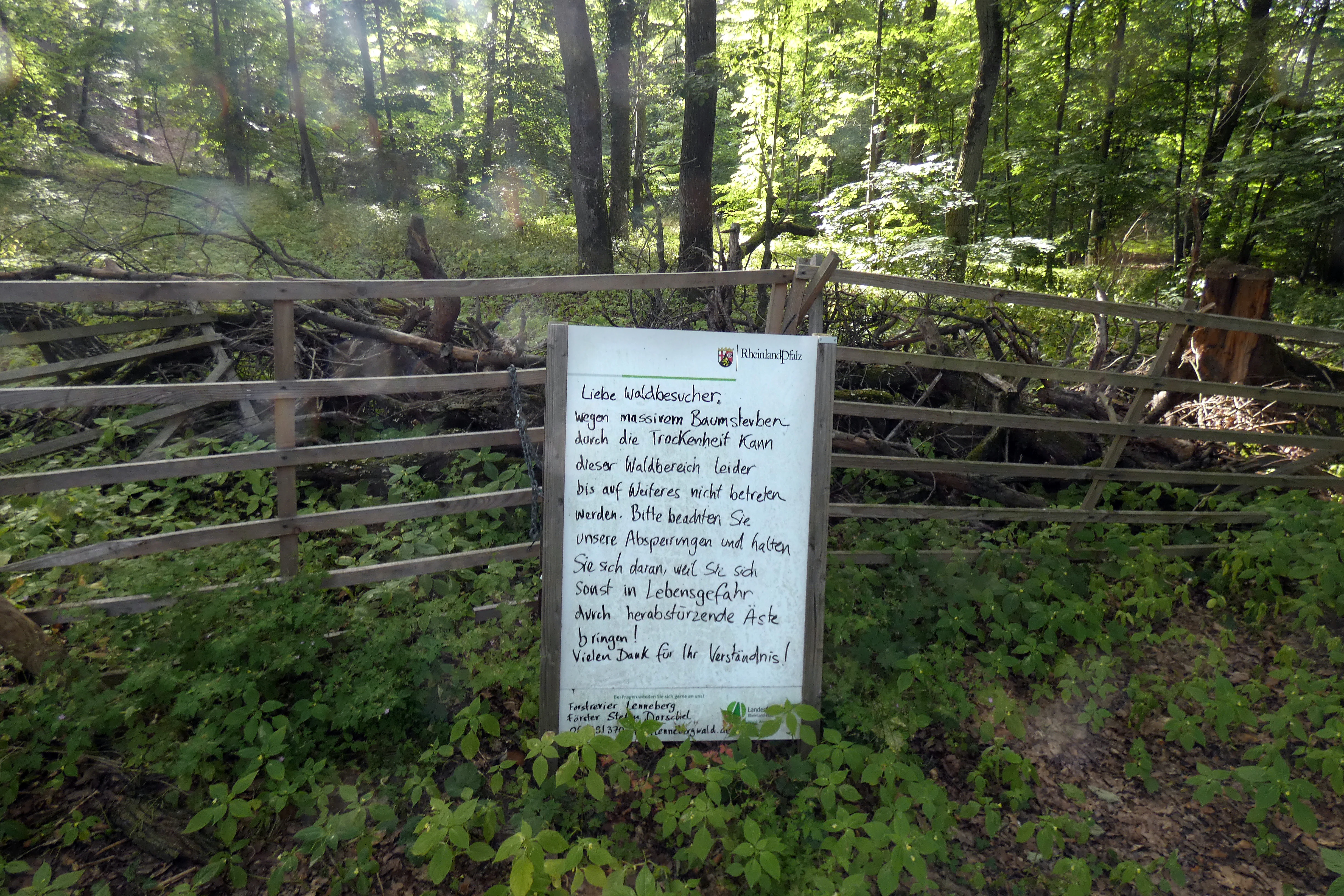
A white informational sign mounted on a wooden gate in a forest, featuring German text notifying visitors about trail closures due to tree mortality.
A warning sign in the Lennebergwald forest advising visitors of trail closures due to tree dieback caused by severe drought.

Lennebergwald history and protected-area timeline

Lennebergwald has functioned as a woodland landscape for centuries within the Rheinhessen region, but its modern identity as a protected natural area took shape in the late twentieth century. In 1996, the regional authorities of Rhineland-Palatinate issued a formal protection order for the Lennebergwald as a Naturschutzgebiet, codifying its status as a nature reserve under state law.

The forest's cultural layer accumulated more gradually. The neo-Gothic Lennebergturm, designed by Philipp Johann Berdellé, was constructed between 1878 and 1880, and the New St. Wendelin Chapel dates from 1862 to 1866. The Jugendstil waterworks buildings at Budenheim and Gonsenheim, both designed by architect Wilhelm Lenz, were inscribed-dated 1907 and 1909 respectively. These structures reflect a period in which the forest was valued both as a scenic and recreational backdrop and as a host for engineered and commemorative architecture on the edge of Mainz.

Between 1987 and 1990, an interdisciplinary research project studied the forest's ecology, the results of which were published in 1991 and remain a key scientific reference for understanding the site's soils, vegetation, and microclimate. In the 2010s and 2020s, repeated drought years exposed the vulnerability of the pine-dominated forests, prompting a transition toward more drought-resilient native species. The conservation order and its subsequent real-world implementation together form the core of the forest's modern institutional history.

Lennebergwald landscape and geographic character

The Lennebergwald's setting is defined by warm, sandy ground and a continental dry-forest character unusual so far inland. The terrain is gently undulating rather than dramatic, with the visual interest emerging from contrasts between open sandy clearings, pine-dominated canopy, oak stands, and small dry grassland patches where sand-specialist plants thrive. Soil temperatures are unusually high for the region, reinforcing the impression of a landscape that sits somewhere between a forest and a sand-steppe.

To the south and west, the forest adjoins agricultural and vine-growing land typical of Rheinhessen, while to the north it meets the expanding outskirts of Mainz, particularly the Finthen and Gonsenheim districts. The neighbouring Mainzer Sand reserve is a closely related but more open sand landscape, and together the two areas form a connected mosaic of sandy habitats that is unusual in central Europe. The Lennebergturm gives visitors an elevated vantage point over this mosaic and is the forest's most prominent landmark.

Hydrologically, the sandy substrate means that surface water quickly percolates downward, producing dry microconditions rather than the wet forest floors common elsewhere in Germany. Culturally constructed landscape elements, including paths, chapels, and the tower, are integrated into the woodland fabric rather than placed on its edge.
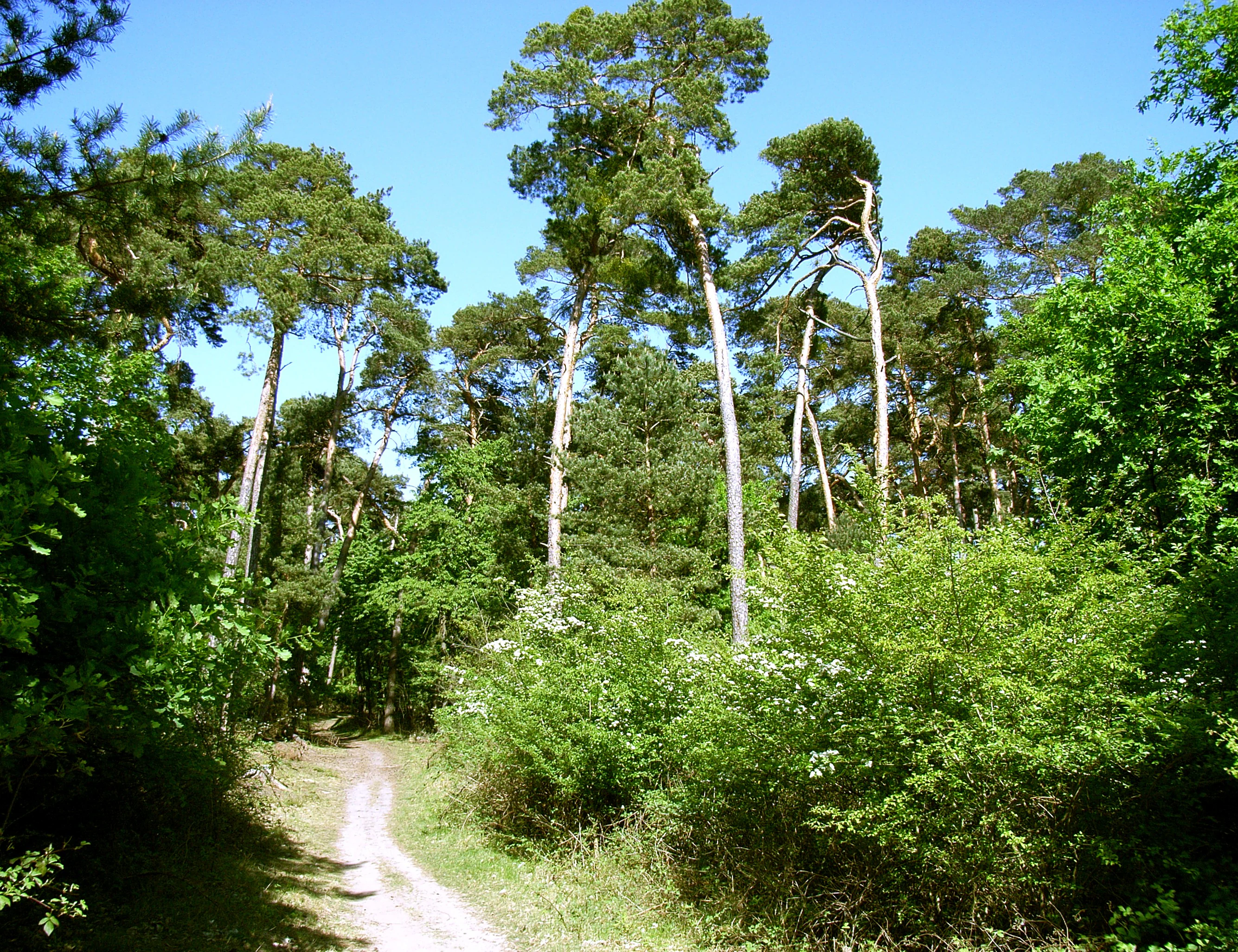
A dirt hiking trail leads into a bright, green forest dominated by tall pine trees under a clear blue sky.
A sandy trail winds through the pine and oak forest of the Lennebergwald.

Lennebergwald ecosystems, habitats, and plant life

Lennebergwald protects one of the more ecologically specialised forest communities in Rhineland-Palatinate. The combination of sandy, free-draining soils and elevated ground temperatures produces a warm microclimate that favours Scots pine and various oaks as the main canopy species. Beneath and between these trees, openings expose patches of dry grassland flora more typical of further south or east in Europe than of the Mainz region itself.

The forest is ecologically inseparable from the neighbouring Mainzer Sand reserve. Together they form the core of a regional sand-ecosystem complex, with overlapping flora including heat- and drought-loving species adapted to bare or sparsely vegetated sand. Among the rarer species mentioned in connection with the forest are the Sandlotwurz, a sand-specialist plant, and orchids such as the Bocksriemenzunge, both indicators of high-quality sand habitats.

Large portions of the Lennebergwald have been deliberately left to develop without active intervention, allowing natural processes, including tree death, regeneration, and soil change, to shape the woodland on their own terms. Where forestry is active, the focus has shifted toward drought-tolerant native broadleaves, including sessile oak with deep taproots, wild service tree, service tree, sweet chestnut, and small-leaved lime, alongside regionally adapted Scots pine seedlings of the Mainzer Sand provenance. This combination of passive and active management marks a deliberate move away from the older pine monocultures that dominated the forest in the mid-twentieth century.

Lennebergwald wildlife and species highlights

Lennebergwald's wildlife character is closely tied to its dry, sandy habitat. The mix of pine canopy, oak stands, dry grassland openings, and warm microclimates supports fauna typical of light-rich, open woodland, including insect communities adapted to dry conditions and ground-nesting species that favour sandy substrates. The forest's ecological link to the Mainzer Sand means that specialists found in that reserve, including rare invertebrates and reptile or insect groups tied to warm sand environments, can also occur here.

Birdlife benefits from the structural variety created by differing ages of pine and oak, by dry clearings, and by the woodland edge interfaces with surrounding agricultural land. Dead and dying trees, although increasingly common due to drought stress, also create habitat for woodpeckers, cavity-nesting species, and saproxylic insects, although managers have had to balance this biodiversity value against safety concerns for visitors on heavily used trails.

Large mammals typical of broader German forests also occur in the area, using the Lennebergwald as part of a wider network of woodland and vineyard-edge habitats in Rheinhessen. The forest's overall wildlife value rests less on charismatic large mammals and more on the richness of its specialist dry-habitat flora and fauna, which it shares with the adjacent Mainzer Sand.

Lennebergwald conservation status and protection priorities

Conservation in the Lennebergwald has shifted from static protection toward active climate adaptation. The 1996 protection order established the formal baseline, but the past decade has highlighted how vulnerable the forest's sandy soils and pine monocultures are to drought. Forestry staff, including district forester Stefan Dorschel, have documented widespread dieback of pines on dry sites and increasing mortality of native beeches, maples, and oaks even on soils that would normally hold water, attributing the trend largely to the missing precipitation of 2018 to 2020.

The current conservation approach combines passive rewilding, leaving large areas to develop without intervention, with targeted planting of drought-tolerant native tree species. Young oaks are favoured for their deep taproots, supplemented by Rheinhessen-typical species such as wild service tree and service tree, alongside sweet chestnut and small-leaved lime. Where pine is replanted, only seedlings of the locally adapted Mainzer Sand pine are used, and small-scale experiments with Mediterranean tree species have been introduced.

Beyond climate pressures, the forest faces additional threats from infrastructure and development proposals, including planned six-lane expansion of the A 643 motorway and the prospect of a large equestrian facility near Uhlerborn. Conservationists see potential ecological linkage with the nearby Ober-Olmer Wald as a future opportunity, suggesting a gradual connection through stepping-stone biotopes that would strengthen the regional sand habitat network.

Lennebergwald cultural meaning and human context

Lennebergwald sits in a landscape with deep cultural layering. Although Rheinhessen is widely known for viticulture, the forest's sandy soils historically supported a different economy and land use, including orchards and small-scale rural infrastructure, traces of which remain in the patchwork of paths and field edges around the woodland.

The nineteenth and early twentieth centuries left a strong architectural mark. The Lennebergturm, built in 1878 to 1880 by Philipp Johann Berdellé, was conceived as a destination within the forest and remains its most recognisable built landmark. Two St. Wendelin chapels, an Old and a New one, reflect local devotional traditions associated with rural woodland and pastoral life. Jugendstil water reservoirs by architect Wilhelm Lenz in Budenheim and Gonsenheim, dated 1907 and 1909, show how the forest was integrated into the technical infrastructure of the growing Mainz region.

Schloss Waldthausen and the Vierzehn-Nothelfer-Kapelle on the forest's edge add further heritage depth. Together these features frame the Lennebergwald not only as a nature reserve but also as a cultural landscape where woodland, architecture, and regional history meet.

Top sights and standout views in Lennebergwald

Lennebergwald's strongest highlights include its unusual dry, sandy forest character within Rheinhessen, its ecological continuity with the Mainzer Sand reserve, and the neo-Gothic Lennebergturm observation tower. The combination of pine and oak woodland, dry grassland openings, and rare sand-specialist plants gives the forest a distinctive Mediterranean-influenced feel far from the coast.

Equally important is its role as a peri-urban green space for Mainz, with a dense network of marked trails that attract hundreds of thousands of visitors each year. A cluster of nineteenth- and early-twentieth-century monuments, including two St. Wendelin chapels, Schloss Waldthausen, and Jugendstil waterworks by Wilhelm Lenz, enriches the forest's identity. Active climate-adaptation forestry, mixing rewilding with replanting of drought-tolerant native species, makes it a current showcase for managing sandy forests under climate change.

Best time to visit Lennebergwald

Lennebergwald can be visited year-round, and its close proximity to Mainz means seasonal conditions matter less for accessibility than for atmosphere. Spring and early summer are particularly rewarding for visitors interested in the forest's dry grassland flora and orchids, when sand-specialist plants are most visible in open patches.

Autumn brings the warm colour tones typical of mixed pine and oak woodland and is generally comfortable for longer walks and cycling on the marked trail network. Winter visits offer quieter conditions and clearer views from the Lennebergturm, though visitors should expect that some paths may be closed after storm or drought damage due to safety concerns from dead or dying trees. Summer can be hot, and the dry soils make the forest especially fire-prone in prolonged dry spells, so visitors should observe any seasonal access notices.


Monthly climate preview

Examine representative long-term averages and recorded weather by month for Lennebergwald

Lennebergwald Climate Normals, Annual Temperature and Monthly Precipitation Profile

Representative coordinates record long-term temperature swings from sub-zero winter minimums to warm summer highs alongside steady monthly precipitation rates. Opening the complete profile reveals full twelve-month tables for detailed meteorological comparison.
Annual mean9 °C
0 °C20 °C
Jan
Feb
Mar
Apr
May13°
Jun17°
Jul20°
Aug19°
Sep15°
Oct
Nov
Dec
Warmest month
July

19.6 °C

Coolest month
January

-0.1 °C

Wettest month
July

2.2 mm/day

Driest month
April

1.5 mm/day

Park location guide

Geography guide, regional context, and park location map for Lennebergwald

Lennebergwald park geography, regions, and map view in Germany

Understand where Lennebergwald sits in Germany through a broader geographic reading of the surrounding landscape, nearby location context, and its mapped position within the national park landscape.

How Lennebergwald fits into Germany

Germany is a federal republic in Western and Central Europe with a population of over 83 million across sixteen constituent states. It is Europe's largest economy by nominal GDP and a major global exporter and importer. The capital is Berlin, and the country borders Denmark, Poland, Czech Republic, Austria, Switzerland, France, Luxembourg, Belgium, and the Netherlands.

Wider geography shaping Lennebergwald in Germany

Germany is located in Western and Central Europe, spanning 357,022 km². It borders Denmark to the north, Poland and the Czech Republic to the east, Austria and Switzerland to the south, and France, Luxembourg, Belgium, and the Netherlands to the west. The country has coastlines on the Baltic Sea and North Sea to the north, with the Alps located in the southern region.

Map view of Lennebergwald

Use this park location map to pinpoint Lennebergwald in Germany, understand its exact geographic position, and read its mapped placement within the surrounding landscape more clearly.

Pigeon | © OpenStreetMap contributors

Location context for Lennebergwald

Rhineland-Palatinate

Visual reference of sandy forest terrain, pine stands, and dry grassland habitats

Lennebergwald Photos and Protected Forest Landscape Scenery

Visual records capture the unusual sandy terrain, pine canopy, and dry grassland habitats defining this protected forest. Photographic documentation reveals the distinct ecological character and land forms spanning the Mainz region.

A white informational sign mounted on a wooden gate in a forest, featuring German text notifying visitors about trail closures due to tree mortality.

A group of tall, dead pine trees stands in a grassy clearing within a forest, with clear blue sky above.

A dirt hiking trail leads into a bright, green forest dominated by tall pine trees under a clear blue sky.

Park atlas

Compare regional protected areas and neighboring dry forest terrain

Exploring Parks Near Lennebergwald and Connected Protected Landscapes

Browse protected areas and natural reserves located near Lennebergwald to examine wider regional ecology. Comparing these surrounding habitats reveals distinct sandy terrain patterns across the Mainz landscape.
A watercolor painting showing a soft, atmospheric landscape with a river flowing through green hills and gentle, misty mountains.
Nature reserveRhineland-Palatinate
About 2.5 km away#1 closest

East

Inselrhein Nature Reserve, Rhineland-Palatinate: A Geographic and Protected-Area Atlas

River islands, floodplain forests, and Upper Rhine wetlands

Inselrhein features a chain of natural river islands and side channels forming a critical wetland habitat. The terrain transition from soft-wood to hardwood forest communities creates a layered landscape. Examine the protected boundaries and geographic significance of this river corridor between Mainz and Bingen, documented within the Rhineland-Palatinate atlas.

Relief
Lowland
Climate
Temperate
Access
Easy access
Scope
Terrestrial
Watercolor painting of a misty river landscape with green trees, reeds, and soft hills in the background.
Nature reserveHesse
About 2.9 km away#2 closest

North

Niederwallufer Bucht Nature Reserve: Rhine Floodplain Landscape and Geographic Context

Protected riparian habitat in the state of Hesse

Niederwallufer Bucht represents a key example of a conserved Rhine riverbank environment. This nature reserve protects a delicate mix of soft-wood forests, sheltered backwater bays, and riparian meadows. By maintaining these wetlands against the backdrop of the heavily settled Rheingau, the site provides a vital node of ecological continuity and a clear look at floodplain terrain within central Germany.

Area
0.13 km²
Established
2000
IUCN
IV
A wide watercolor illustration showing a winding river flowing through a green floodplain with scattered trees and pale pink and purple hills in the distance.
Nature reserveHesse
About 4.3 km away#3 closest

Northeast

Rettbergsaue Nature Reserve: Geography and Protected Landscapes in the Rhine Valley

A vital river island ecosystem and floodplain forest in Hesse.

Rettbergsaue serves as an essential riverine habitat in the Upper Rhine. This nature reserve, characterized by its alluvial woodland and riparian meadows, offers a detailed study of sediment-formed islands and the interplay between main-channel water flow and sheltered side-arm environments within the state of Hesse.

Area
0.68 km²
Established
1978
Relief
Lowland
Climate
Temperate
A horizontal watercolor painting of a river landscape with lush green trees, grasses, and a winding waterway under a soft light.
Nature reserveHessen
About 5.3 km away#4 closest

West

Mariannenaue Nature Reserve: Protected River Island Geography and Landscape Atlas

Rhine river island and floodplain forest in Hessen, Germany.

Mariannenaue serves as a prominent example of a protected inland island in the Upper Rhine. Its geography encompasses a complex mix of veteran floodplain forest, still-water habitats, and centuries-old vineyard cultivation. This detail page provides insights into the park boundaries, the surrounding riverine terrain, and the ecological network that connects this site to the broader Rheingau landscape.

Area
1.96 km²
Established
1972
Relief
Lowland
Climate
Temperate
Nature reserveRhineland-Palatinate
About 5.6 km away#5 closest

South

Wiesen am Layenhof, Ober-Olmer Wald Nature Reserve: Mapped Landscapes of Rhineland-Palatinate

Protecting a delicate balance of beech woodland and rare dry grassland ecosystems.

Spanning 533 hectares near Mainz, this nature reserve serves as a critical refuge for biodiversity, characterized by its interlocking habitat types including oak-beech forests and orchid-rich dry swards. The geography is shaped by small seasonal pools and a network of pathways that provide access to the protected terrain, offering a clear view of how woodland and meadow habitats interact within the landscape of Rhineland-Palatinate.

Area
5.33 km²
Established
2017
Relief
Lowland
Scope
Terrestrial
A horizontal watercolor illustration of a natural landscape featuring a small body of water or pond in the foreground, surrounded by grassy banks, low hills in the distance, and soft-colored vegetation.
Nature reserveRhineland-Palatinate
About 6 km away#6 closest

West

Sandgrube am Weilersberg Nature Reserve and Protected Landscape Map

Rhineland-Palatinate, Germany protected area

Sandgrube am Weilersberg is a protected nature reserve in Rhineland-Palatinate, Germany, known for its compact mosaic of calcareous sand slopes and wet meadows. Part of the Natura 2000 network, the site preserves rare steppe flora and wetland ecosystems that emerged following former sand extraction. The terrain supports significant entomological, botanical, and bryological diversity maintained through active grazing.

Area
0.095 km²
Established
1986
Relief
Lowland
Climate
Temperate
Nature reserveRhineland-Palatinate
About 6.4 km away#7 closest

Southwest

Hangflächen um den Heidesheimer Weg: Nature Reserve Geography and Protected Landscape Context

Mainz-Bingen, Rhineland-Palatinate Nature Reserve

Hangflächen um den Heidesheimer Weg contains an unusual ecological convergence of sand dunes, open flats, and calcareous grasslands near Ingelheim am Rhein. This nature reserve provides critical protection for a fragmented yet highly structured landscape where springs and wetland zones intersect with warm, dry slopes. The area preserves a significant biotope complex of national importance within the Upper Rhine Plain.

Area
3.348 km²
Established
2003
A horizontal watercolor illustration of a natural valley scene, featuring an open meadow in the foreground, forest edges in the midground, and rolling hills in the background.
Nature reserveHesse
About 8.7 km away#8 closest

North

Rechtebachtal bei Georgenborn Nature Reserve: Geographic Profile and Protected Landscape

A mapped stream valley ecosystem in the Hesse Taunus foothills

The Rechtebachtal bei Georgenborn nature reserve protects a two-part valley corridor along the Rechtebach stream near Georgenborn and Martinsthal. This site preserves rare habitat mosaics of meadows and woodland that characterize the transitional zone between the Taunus highlands and the Rhine valley, offering a distinct study in regional conservation geography.

Area
0.185 km²
Established
1989
IUCN
IV
Relief
Upland

Common questions about visiting, size, designation, and location context for Lennebergwald

Lennebergwald FAQs for park facts, access, geography, and protected area context

Find quick answers about Lennebergwald, including protected-area facts, park geography, trail and visitor context, and how the park fits into its surrounding country and regional landscape.
MoriAtlas Explorer

Continue Your Protected Areas Search Across the Global Atlas

Deepen your exploration by continuing the structured search for national parks and protected areas worldwide. Utilize the comprehensive filtering capabilities to compare different conservation landscapes and refine your understanding of global park geography. Discover more about the distribution and characteristics of protected natural areas.

Global natural geography