Mori Atlas logo
National parkMado Hot Spring National Park

Discover the unique Mado Hot Spring National Park protected area within Maguindanao del Norte

Mado Hot Spring National Park: Protected Geothermal Landscape and Therapeutic Waters

Mado Hot Spring National Park represents a significant protected area in Maguindanao del Norte, Philippines, celebrated for its unique geothermal features. Established in 1939, this national park preserves a natural hot spring system, including a therapeutic pool, recognized for its traditional wellness value. Explore the mapped boundaries and distinct landscape context of this protected geothermal site.

hot springsgeothermal featurestherapeutic watersMindanaonational parkPhilippines protected areas

Mado Hot Spring National Park

National park

Park overview

Structured park overview, official facts, and landscape profile for Mado Hot Spring National Park

Mado Hot Spring National Park park facts, protected area profile, and essential visitor context

Review the core facts for Mado Hot Spring National Park, including designation, size, terrain, visitor scale, habitats, and operating context in one park-focused overview.

About Mado Hot Spring National Park

Mado Hot Spring National Park represents a unique protected area within the Philippines' network of national parks, distinguished by its geothermal character rather than the mountainous or forested landscapes that define many other Philippine protected areas. Located in central Mindanao, the park occupies a relatively modest 48-hectare footprint centered on a naturally occurring hot spring system. The thermal waters emerge from underground geological formations, carrying minerals that have contributed to the spring's reputation as a medicinal bathing destination. Beyond the hot spring itself, the park encompasses surrounding lands that contribute to the overall protected area ecosystem. The proximity to Awang Airport and Cotabato City positions the park as an accessible natural attraction for both local residents and visitors to the region. The establishment of the park in 1939 predates many of the Philippines' protected areas and reflects early recognition of the need to preserve significant natural features beyond simply scenic landscapes.

Quick facts and research context for Mado Hot Spring National Park

Mado Hot Spring National Park spans 48 hectares in Datu Odin Sinsuat municipality, Maguindanao del Norte, Mindanao, Philippines. It was established on September 25, 1939, making it one of the Philippines' oldest national parks. The park is classified under IUCN Category II as a national park and is managed by the Department of Environment and Natural Resources. The central feature is a therapeutic hot spring that feeds a natural swimming pool, accompanied by a health resort. The park lies in a predominantly agricultural region of central Mindanao, near the provincial capital area.

Protection and recognition

Verifying terrestrial management scope and official conservation framework listings.

Official Protection Status and Protected Area Designation of Mado Hot Spring National Park

Geographers can review the documented terrestrial protection status and designation history of Mado Hot Spring National Park within global conservation frameworks. Analyzing structured records helps conservationists verify official boundary protections and independent international listings without relying on unverified claims.

Protection details

Protection scope
Terrestrial
Transboundary protection
No
Park context

Deeper park guide and search-rich context for Mado Hot Spring National Park

Mado Hot Spring National Park history, landscape, wildlife, and travel context

Explore Mado Hot Spring National Park through its history, landscape character, ecosystems, wildlife, conservation priorities, cultural context, and seasonal travel timing in a structured park guide built for atlas discovery and search intent.

Why Mado Hot Spring National Park stands out

Mado Hot Spring National Park is best known for its geothermal hot spring, which has been traditionally valued for medicinal and therapeutic purposes. The natural warm water pool at the park's center attracts visitors seeking the purported health benefits of the mineral-rich thermal waters. The combination of the hot spring, natural pool, and developed resort facilities creates a distinctive protected area that blends natural resource preservation with recreational wellness use.

Mado Hot Spring National Park history and protected-area timeline

Mado Hot Spring National Park was established on September 25, 1939, through Proclamation No. 456 issued by the national government. This designation placed the hot spring and surrounding lands under formal protection as a national park, making it one of the earliest protected areas established in the Philippines during the American colonial period. The proclamation recognized both the natural significance and the recreational value of the hot spring area. Over the decades, the park has been managed by the Department of Environment and Natural Resources as part of the national protected areas system. The historical continuity of the park's protected status spans multiple political administrations and has provided ongoing recognition of the geothermal resource's special character within the Philippine environmental protection framework.

Mado Hot Spring National Park landscape and geographic character

The landscape of Mado Hot Spring National Park is characterized by its geothermal features rather than dramatic topographic relief. The terrain in the surrounding area consists of gentle rolling lands typical of the central Mindanao basin, primarily used for agricultural purposes. At the park's core, the hot spring creates a distinctive landscape where warm mineral-rich water surfaces to form a natural pool. The area around the spring has been developed with basic infrastructure to accommodate visitors, including a health resort. Unlike mountainous or forested protected areas, this park's landscape is defined by its geological and hydrological characteristics, with the thermal waters creating a unique environmental setting within the broader tropical landscape of Maguindanao.

Mado Hot Spring National Park ecosystems, habitats, and plant life

The nature of Mado Hot Spring National Park is defined primarily by its geothermal environment rather than the terrestrial ecosystems more typical of mountain forest parks. The hot spring system creates a unique habitat characterized by warm water emerging from underground sources. The thermal waters contain minerals that contribute to the spring's therapeutic reputation. The surrounding park area includes tropical vegetation typical of the Mindanao lowland environment. While the park is not primarily known for biodiversity conservation, the protected status helps preserve the hot spring system and its immediate surroundings. The geothermal nature of the site represents a distinct category of protected area within the Philippine landscape, preserving a geological feature of natural significance.

Mado Hot Spring National Park conservation status and protection priorities

Mado Hot Spring National Park contributes to the Philippines' protected area network under IUCN Category II, reflecting its designation as a national park focused on ecosystem protection and preservation. While the park's primary significance lies in its geothermal resource rather than biodiversity, the protected status ensures the hot spring system and surrounding lands remain shielded from development pressures that might otherwise degrade the resource. The national park designation provides a framework for ongoing management by the Department of Environment and Natural Resources and ensures that the therapeutic hot spring remains available for current and future generations. The park represents an early example of Philippine environmental protection, established when the concept of national parks was still relatively new in the country.

Mado Hot Spring National Park cultural meaning and human context

Mado Hot Spring National Park is located in Maguindanao del Norte, a province in the Bangsamoro Autonomous Region in Muslim Mindanao. The surrounding region is predominantly inhabited by Maguindanao people, a major Muslim ethnic group in the Philippines with deep cultural traditions tied to the land. The hot spring has likely held significance for local communities for generations, with the therapeutic properties of the warm waters being part of traditional knowledge and practice. The area exists within a broader cultural landscape where agriculture and settlement have shaped the human-environment relationship over centuries. The park's establishment in 1939 occurred within a colonial context but built upon local recognition of the spring's special qualities.

Top sights and standout views in Mado Hot Spring National Park

The primary highlight of Mado Hot Spring National Park is its therapeutic hot spring, which produces warm mineral-rich waters that visitors have used for generations for perceived health benefits. The natural swimming pool formed by the spring provides a unique bathing experience within a protected natural setting. The park's historical significance as one of the Philippines' earliest national parks, established in 1939, adds depth to its identity beyond simple recreational value. The accessibility from Cotabato City and proximity to Awang Airport make it a convenient natural attraction for travelers to central Mindanao.

Best time to visit Mado Hot Spring National Park

Mado Hot Spring National Park can be visited throughout the year given its location in the tropical climate of Mindanao. The hot spring provides a consistent attraction regardless of season, as the warm waters are not dependent on seasonal rainfall or temperature variations. The dry season from March to May tends to offer more predictable weather for outdoor activities, while the wet season from June to February brings occasional rainfall that may affect visit planning. Visitors seeking thermal bathing may find the experience consistent year-round, though checking local conditions before traveling remains advisable.

Monthly climate preview

Long-term monthly temperature averages and precipitation trends across Maguindanao del Norte

Mado Hot Spring National Park Climate and Average Weather by Month

Long-term climatology data for Mado Hot Spring National Park reveals a warm year-round cycle where mean temperatures stay between 23 and 25 degrees Celsius while daily precipitation ranges from three to nearly ten millimeters. Reviewing the complete monthly profile reveals detailed historical trends and provides deeper context on the regional climate patterns of Maguindanao del Norte.
Annual mean24 °C
23 °C25 °C
Jan23°
Feb24°
Mar24°
Apr25°
May25°
Jun24°
Jul24°
Aug24°
Sep24°
Oct24°
Nov24°
Dec24°
Warmest month
April

25.3 °C

Coolest month
January

23.5 °C

Wettest month
June

9.9 mm/day

Driest month
March

3.1 mm/day

Park location guide

Geography guide, regional context, and park location map for Mado Hot Spring National Park

Mado Hot Spring National Park park geography, regions, and map view in Philippines

Understand where Mado Hot Spring National Park sits in Philippines through a broader geographic reading of the surrounding landscape, nearby location context, and its mapped position within the national park landscape.

How Mado Hot Spring National Park fits into Philippines

The Philippines, officially the Republic of the Philippines, is an archipelagic nation in Southeast Asia comprising approximately 7,641 islands categorized into three main geographical divisions: Luzon, Visayas, and Mindanao. Located in the western Pacific Ocean, it shares maritime borders with Taiwan, Japan, Palau, Indonesia, Malaysia, Vietnam, and China. Manila serves as the capital city, while Quezon City is the most populated city, both within Metro Manila.

Wider geography shaping Mado Hot Spring National Park in Philippines

The Philippines is an archipelagic nation in Southeast Asia, positioned in the western Pacific Ocean. Its islands are bounded by the South China Sea to the west, Philippine Sea to the east, and Celebes Sea to the south. The country shares maritime borders with Taiwan to the north, Japan to the northeast, Palau to the east and southeast, Indonesia to the south, Malaysia to the southwest, Vietnam to the west, and China to the northwest.

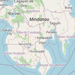
Map view of Mado Hot Spring National Park

Use this park location map to pinpoint Mado Hot Spring National Park in Philippines, understand its exact geographic position, and read its mapped placement within the surrounding landscape more clearly.

Pigeon | © OpenStreetMap contributors

Location context for Mado Hot Spring National Park

Maguindanao del Norte
Park atlas

Compare the unique geothermal landscape of Mado Hot Spring National Park with other protected areas across central Mindanao and the Philippines.

Explore Other National Parks and Protected Areas Near Mado Hot Spring National Park in Mindanao

Delve into an expanded list of national parks and protected areas adjacent to Mado Hot Spring National Park, revealing the diverse conservation landscapes and geothermal features of Mindanao. This geographic context allows for direct comparison of park characteristics and regional protected-area distribution, enhancing your atlas-based exploration of the Philippines.
National parkLanao del Sur
About 80 km away#1 closest

North

Salikata National Park: Explore Philippines National Park Geography

Mapped protected area boundaries and regional context.

Investigate Salikata National Park, a key protected area designated as a national park within Lanao del Sur, Philippines. This detailed view provides essential context for understanding its mapped boundaries, its place in the regional geography, and its significance as a protected landscape. Discover the unique geographic attributes that define Salikata National Park for atlas-based exploration.

Established
1965
IUCN
V
Relief
Mountain
Climate
Tropical
National parkLanao del Sur
About 81 km away#2 closest

North

Lake Butig National Park: National Park Atlas and Geographic Discovery in Lanao del Sur

Discover its mapped boundaries and regional landscape context.

Lake Butig National Park is a protected national park in the Philippines, located within Lanao del Sur. This entry provides specific geographic information and supports atlas exploration by detailing the park's mapped boundaries and its place within the regional landscape. Understand the terrain and protected area context crucial for geographic study and understanding Philippine natural landscapes.

Area
0.68 km²
Established
1965
IUCN
V
Relief
Mountain
National parkLanao del Sur
About 81 km away#3 closest

North

Pantuwaraya Lake National Park: National Park Atlas and Mapped Landscape

Explore the protected area and regional geography of Lanao del Sur.

Understand Pantuwaraya Lake National Park as a defined protected landscape and a significant national park within the Philippines. This entry focuses on its geographic placement in Lanao del Sur, providing context for its mapped boundaries and natural features. Users can explore its representation within a broader atlas of protected lands, gaining insight into its role and landscape identity.

Area
0.2 km²
Established
1965
IUCN
V
Climate
Tropical
National parkLanao del Sur
About 84 km away#4 closest

North

Sacred Mountain National Park National Park: Detailed Geographic and Protected Landscape Context

Mapped boundaries and regional geography for Sacred Mountain National Park.

Sacred Mountain National Park, a significant national park in Lanao del Sur, offers a distinct protected landscape for atlas-driven discovery. This detailed entry provides insight into its geographic scope and mapped presence, allowing for a deeper understanding of its role within the region. Explore the specific natural terrain and protected area features that define Sacred Mountain National Park, grounded in factual geographic data.

Area
0.94 km²
Established
1965
IUCN
V
Relief
Mountain
Protected areaMaguindanao del Sur
About 87 km away#5 closest

Southeast

Lake Buluan Protected Area: An Atlas Guide to Mindanao Lowland Freshwater Landscapes

Geography and hydrological map of the Maguindanao del Sur wetlands.

Lake Buluan represents a vast, shallow freshwater system known for its extensive marshes and role as a central basin for multiple Mindanao river tributaries. As a protected landscape in Maguindanao del Sur, it offers a distinct look at lowland hydrological patterns, floodplain dynamics, and the cultural history associated with the region's inland water resources.

Area
61.34 km²
Relief
Lowland
Water
Water-dominated
National parkLanao del Sur
About 87 km away#6 closest

Northeast

Rungkunan National Park: Mapped Protected Landscape and Regional Geography Overview

Discover Rungkunan National Park's protected boundaries and landscape context.

Gain insight into Rungkunan National Park, a protected national park situated in Lanao del Sur. This page details the park's geographic positioning, mapped outlines, and its significance as a conservation landscape. It provides essential context for understanding the distribution of protected areas and the regional geography of the Philippines, facilitating a deeper atlas-style exploration.

Established
1965
IUCN
V
Water
Minor water
National parkPhilippines
About 96 km away#7 closest

East

Mount Apo Natural Park: Volcanic Terrain and Biodiversity in Mindanao, Philippines

Mapping the highest peak and endemic-rich montane ecosystems

Spanning the provinces of Davao del Sur and Cotabato, Mount Apo Natural Park protects the volcanic massif of Mount Apo and its extensive forest surroundings. The park exhibits a distinct altitudinal zonation that supports a significant concentration of endemic birds, mammals, and plant life. Beyond its ecological relevance, the area features dramatic volcanic ridges, cascading waterfalls, and the high-elevation Lake Venado, forming a vital component of the regional natural heritage network in the southern Philippines.

Area
640.53 km²
Established
2004
Relief
Mountain
Climate
Tropical
Protected landscapeZamboanga del Sur
About 143 km away#8 closest

West

Dumanquilas Protected Landscape/Seascape: Mapping Zamboanga Peninsula Coastal Ecosystems

Integrated Marine and Mangrove Reserve Geography

Dumanquilas Protected Landscape/Seascape functions as a comprehensive conservation reserve combining land and sea. This atlas entry details the geography of a bay-centered ecosystem, highlighting the crucial connection between mangrove forest networks and the extended marine buffer within the Celebes Sea.

Area
259.48 km²
Established
1999
Relief
Lowland
Scope
Mixed

Common questions about visiting, size, designation, and location context for Mado Hot Spring National Park

Mado Hot Spring National Park FAQs for park facts, access, geography, and protected area context

Find quick answers about Mado Hot Spring National Park, including protected-area facts, park geography, trail and visitor context, and how the park fits into its surrounding country and regional landscape.
MoriAtlas Explorer

Continue Your Protected Areas Search Across the Global Atlas

Deepen your exploration by continuing the structured search for national parks and protected areas worldwide. Utilize the comprehensive filtering capabilities to compare different conservation landscapes and refine your understanding of global park geography. Discover more about the distribution and characteristics of protected natural areas.

Global natural geography