Mori Atlas logo
Protected landscapeMahndorfer Düne

Tracing the post-glacial sandy terrain and layered habitats of a unique German urban refuge.

Mahndorfer Düne: A Rare Inland Dune Protected Landscape in the Bremen Lowlands

Mahndorfer Düne represents a critical remnant of the inland dune systems that once characterized the Bremen lowlands. This protected landscape preserves a rare post-glacial sand deposit, showcasing a compact sequence of habitats including open dunes, dry heath grassland, and birch-oak forest. As a key geographical anchor in eastern Bremen, the site serves as an essential window into the natural history and geological development of the region.

inland duneBinnendünelandscape protection areaLandschaftsschutzgebietdry heathsandy grassland

Mahndorfer Düne

Protected landscape

Park overview

Structured park overview, official facts, and landscape profile for Mahndorfer Düne

Mahndorfer Düne park facts, protected area profile, and essential visitor context

Review the core facts for Mahndorfer Düne, including designation, size, terrain, visitor scale, habitats, and operating context in one park-focused overview.

About Mahndorfer Düne

The Mahndorfer Düne is a compact but ecologically rich inland dune complex preserved as a landscape protection area on the southeastern edge of Bremen. Inland dunes, known in German as Binnendünen, are landforms created by windblown sand during and after the last Ice Age. Across northern Germany many such dunes were leveled over centuries for farming, forestry, or sand mining, and within the city limits of Bremen very few open dune remnants have survived. The Mahndorfer Düne is one of those rare surviving fragments.

Its protected area covers about 2.7 hectares and forms a long, narrow strip tucked between the freight bypass railway of the Wanne-Eickel to Hamburg line to the north and a band of birch-oak forest to the south. The shape of the protected zone reflects the dune's linear orientation and the practical limits imposed by transport infrastructure and the transition into the surrounding marshland. Within that strip, the eastern section contains the actual dune body, a low sandy rise with open, sparsely vegetated surfaces, while the western section flattens out into sandier terrain.

Ecologically the area matters because it preserves several dry, sandy habitat types in close proximity. On the still mobile parts of the dune surface, pioneer species such as silvergrass and sand sedge dominate, creating the kind of thin, sun-exposed vegetation typical of active or recently stabilized inland dunes. In the flatter, more stabilized areas farther west, dry grassland and sandy heath with broom heather reflect a later stage of succession on the same sandy substrate. The wooded margins, dominated by birch and oak and rich in standing and fallen deadwood, form the third ecological layer and act as a buffer against the surrounding urban and agricultural land uses.

The site has been owned by BUND, the Friends of the Earth and Nature Germany federation, since 1985. Under BUND's stewardship, regular habitat management is carried out, particularly aimed at preventing the open dune and heath surfaces from becoming overgrown by shrubs and trees, a natural process that would otherwise gradually erase the very landscape features that make the area ecologically distinctive. A footpath runs through the protected area, providing local residents and visitors with access to the dune without compromising its protected status.

Quick facts and research context for Mahndorfer Düne

The Mahndorfer Düne is an inland dune, a Binnendüne, in the city of Bremen in northern Germany, specifically in the southeast of the Arbergen locality within the Hemelingen district. It has been protected as a Landschaftsschutzgebiet, a landscape protection area, of about 2.7 hectares. The site consists of an actual dune remnant in the east and flatter sandy terrain to the west, bounded on one side by a railway embankment and on the other by birch-oak forest. Since 1985 it has been owned and managed by BUND, the German Friends of the Earth and Nature organisation, which runs active habitat care to counter the natural tendency of the open sand to become overgrown.

Protection and recognition

Examine the official protection status, designation history, and territorial scope for Mahndorfer Düne.

Mahndorfer Düne Protection Status and Terrestrial Conservation Scope

Mahndorfer Düne features a documented terrestrial protection scope without imported international recognition sources. Review the official conservation status and administrative designation records for this protected area.

Protection details

Protection scope
Terrestrial
Transboundary protection
No
Park context

Deeper park guide and search-rich context for Mahndorfer Düne

Mahndorfer Düne history, landscape, wildlife, and travel context

Explore Mahndorfer Düne through its history, landscape character, ecosystems, wildlife, conservation priorities, cultural context, and seasonal travel timing in a structured park guide built for atlas discovery and search intent.

Why Mahndorfer Düne stands out

The site is best known as one of the last surviving inland dune relicts within Bremen itself. Inland dunes of this kind were once a widespread element of the regional landscape, shaped by windblown glacial sand, but most have been leveled for agriculture, sand extraction, or development. The Mahndorfer Düne stands out because its open sand surfaces and dry grass vegetation still reflect that original dune character, making it a small but visually distinctive reminder of the city's geological past. It is also notable for its combination of contrasting microhabitats. In a very compact area it brings together open sand with pioneer grasses such as silvergrass and sand sedge, adjoining dry heath grassland dominated by heather, and a more wooded fringe of birch-oak forest with abundant deadwood. This sharp ecological layering, set against the dense urban and infrastructural surroundings of eastern Bremen, is the defining feature of the place.
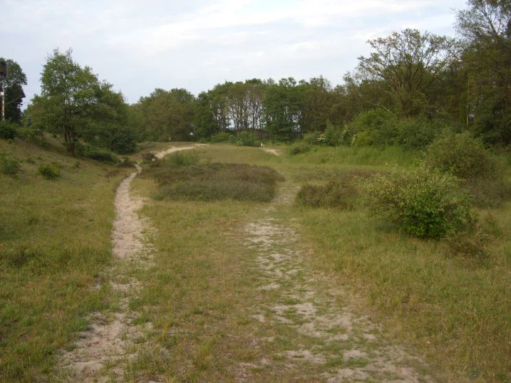
A sandy path winds through a low dune landscape with patches of sparse grass and shrubs under a cloudy sky.
A view of the sandy trails and vegetation at Mahndorfer Düne nature reserve.

Mahndorfer Düne history and protected-area timeline

The physical origins of the Mahndorfer Düne reach back to the last Ice Age, when strong winds blew sand out of the glacial outwash plains and deposited it into the low ridges that still define the site today. Over the intervening millennia, the inland dune landscape around Bremen was repeatedly leveled for agriculture, stripped for sand, or absorbed by urban expansion. By the late twentieth century almost no such open dune remnants survived within the city.

The site's modern history begins in 1985, when the area was taken on by BUND, the German federation Friends of the Earth and Nature, an organization with a long tradition of acquiring and managing small but ecologically valuable sites across Germany. Through its Bremen district group, BUND has since owned and actively managed the dune, framing it as both a piece of local heritage and a habitat worth preserving. The continuing survival of the Mahndorfer Düne as a recognisable inland dune within the city is closely tied to this long-running stewardship, which has used grazing, scrub clearance, and other habitat care measures to slow the natural succession toward woodland.

Mahndorfer Düne landscape and geographic character

The landscape of the Mahndorfer Düne is shaped by the contrast between its small open sandy form and the encroaching edges of city, railway, and woodland. The actual dune body is a low rise of loose sand, a textbook example of a post-glacial inland dune, with a slightly humped profile and sun-exposed slopes. To the west of the dune remnant the terrain flattens into a broader plain of sand and gravelly substrate, still recognisable as part of the same depositional system but without the relief of the dune itself.

On the western, downwind side of the dune the protection area is partly bounded by the embankment of the freight bypass railway line. This man-made edge is unusually hard for a protected natural area, yet it has the side effect of shielding the dune from further development. To the south the dune meets the older marshland landscape typical of this part of the Bremen lowlands, and the boundary between the two is marked by a band of birch-oak woodland. The result is a landscape that reads as a layered cross-section: open dune on top, sandy grassland and heath in the middle, and forest with deadwood at the edge, all within a few hundred meters of each other.

Mahndorfer Düne ecosystems, habitats, and plant life

The dune supports a sequence of vegetation types that mirror the natural development of sandy post-glacial surfaces, from active or recently stabilized sand through dry grassland and heath to woodland. The most exposed parts of the dune surface carry pioneer vegetation, including extensive stands of silvergrass and sand sedge, both classic indicators of open sandy substrates in northern Germany. These plants are adapted to dry, nutrient-poor conditions and tolerate the shifting sand better than taller competitors.

In the flatter western portion of the site the substrate is more stable, and here the vegetation has shifted toward dry grassland, known as Magerrasen, and sandy heath. Patches of broom heather dominate in the most acidic and nutrient-poor spots, completing the classic heathland character. The heath communities depend on the continued removal of encroaching scrub and trees; without regular management they would quickly transition into closed woodland, just as they have over most of the surrounding landscape.

The wooded fringe of the dune is dominated by birch and oak, with a notably high proportion of standing and fallen deadwood. This deadwood is ecologically valuable because it provides habitat for insects, fungi, and cavity-nesting species, and it helps integrate the dry dune habitats with the wetter soils of the surrounding marshland to the south.

Mahndorfer Düne wildlife and species highlights

Because the site is small and heavily framed by infrastructure and forest, its wildlife value lies less in large mammals or charismatic species and more in the specialised communities of sandy, dry, and semi-open habitats. Pioneer sandy habitats like those on the dune surface support specialised invertebrates, including ground-nesting bees, sand wasps, and beetles adapted to warm, exposed sand. These species are often the first to disappear when open sandy areas are lost to development or succession.

The heath and dry grassland sections host insects associated with heather and other low-growing plants, supporting local populations of butterflies, moths, and other pollinators. The wooded margin, with its high share of deadwood, adds another ecological layer by providing breeding and feeding habitat for a variety of forest-dependent insects, fungi, and cavity-using birds. Although the protected area is too small to support major populations of larger wildlife, the combination of habitat types in close proximity makes it disproportionately valuable for the broader ecological network of eastern Bremen.

Mahndorfer Düne conservation status and protection priorities

The Mahndorfer Düne is protected as a Landschaftsschutzgebiet, a landscape protection area, one of the main categories of regional nature conservation in Germany focused on preserving the character of a specific landscape. Its protections acknowledge both the geological and the ecological value of an inland dune surviving within a major city, along with the surrounding dry grassland and heath vegetation that depends on continued sandy, open conditions.

The site has been owned by BUND since 1985, which is unusual because most landscape protection areas in Germany remain in private or municipal ownership while being formally protected. Direct ownership has allowed BUND Bremen to run an active management program aimed at keeping the open sand and heath areas from being lost to natural succession. Without this intervention, scrub and trees would gradually close over the dune, and the sandy character that makes the site ecologically distinctive would disappear within a few decades.

Conservation significance is enhanced by the proximity of the dune to related but separate Bremen sites: the Mahndorfer Gräberfeld, an archaeological burial ground, and the Mahndorfer Marsch, the surrounding marshland. Together with these areas, the dune forms part of a small mosaic of protected and semi-natural landscapes in eastern Bremen, providing connectivity between sandy inland habitats and the wetter marsh habitats to the south.

Mahndorfer Düne cultural meaning and human context

The Mahndorfer Düne carries cultural meaning less through built heritage than through landscape heritage. For residents of eastern Bremen, it is a reminder that the city's surroundings were not always a flat, urban lowland environment. The dune is a tangible piece of post-glacial geological history that can be observed on foot within minutes of residential neighborhoods, and as such has become a small but familiar local landmark.

The site is also commonly mentioned in regional nature guides and walking maps together with the nearby Mahndorfer Gräberfeld, a prehistoric burial field, and the Mahndorfer Marsch, the surrounding marshland. This pairing reflects a local perception of the southeast of Arbergen as a corner of Bremen where several distinct layers of landscape and history converge, from prehistoric archaeology through glacial geology to modern nature conservation.

Top sights and standout views in Mahndorfer Düne

The defining feature of the Mahndorfer Düne is its status as one of the last open inland dune relics inside Bremen, set within a compact 2.7 hectare protected area. Within that small footprint, visitors can see a layered sequence of habitats, from active sandy dune surface through dry heath grassland to birch-oak woodland, each representing a different stage of post-glacial landscape development.

Equally notable is the long-running BUND stewardship, which has preserved an unusual urban conservation arrangement in which a national environmental organisation owns and directly manages a landscape protection area. The site's combination of geological significance, ecological diversity, and accessibility makes it a particularly rewarding microcosm of the region's natural history.

Best time to visit Mahndorfer Düne

Because the dune is best appreciated for its open sandy character and its heath vegetation, late spring through early autumn tends to be the most rewarding period. In late spring and early summer the silvergrass and sand sedge on the dune surface come into growth, and the heather in the flatter western section begins to develop its characteristic green to purple colour transition. Visiting in early morning or evening during warmer months also brings softer light over the open sand and a better chance of observing the specialised insects that use the site.

In winter the dune is less visually expressive, although its wooded margins and deadwood structures remain ecologically active. Visitors should generally stick to the marked footpath to avoid disturbing fragile sandy and heath surfaces regardless of season.

Monthly climate preview

Long-term representative point measurements tracking monthly temperature and precipitation variation at Mahndorfer Düne

Mahndorfer Düne Climate Normals, Annual Temperature and Precipitation Rhythm

Representative point records from NASA POWER outline the long-term temperature progression and precipitation rhythm across twelve months at Mahndorfer Düne. Reviewing the complete monthly profile provides detailed historical baseline metrics without relying on short-term forecasts.
Annual mean9 °C
1 °C18 °C
Jan
Feb
Mar
Apr
May13°
Jun16°
Jul18°
Aug18°
Sep14°
Oct10°
Nov
Dec
Warmest month
July

18 °C

Coolest month
January

1 °C

Wettest month
July

2.5 mm/day

Driest month
April

1.4 mm/day

Park location guide

Geography guide, regional context, and park location map for Mahndorfer Düne

Mahndorfer Düne park geography, regions, and map view in Germany

Understand where Mahndorfer Düne sits in Germany through a broader geographic reading of the surrounding landscape, nearby location context, and its mapped position within the national park landscape.

How Mahndorfer Düne fits into Germany

Germany is a federal republic in Western and Central Europe with a population of over 83 million across sixteen constituent states. It is Europe's largest economy by nominal GDP and a major global exporter and importer. The capital is Berlin, and the country borders Denmark, Poland, Czech Republic, Austria, Switzerland, France, Luxembourg, Belgium, and the Netherlands.

Wider geography shaping Mahndorfer Düne in Germany

Germany is located in Western and Central Europe, spanning 357,022 km². It borders Denmark to the north, Poland and the Czech Republic to the east, Austria and Switzerland to the south, and France, Luxembourg, Belgium, and the Netherlands to the west. The country has coastlines on the Baltic Sea and North Sea to the north, with the Alps located in the southern region.

Map view of Mahndorfer Düne

Use this park location map to pinpoint Mahndorfer Düne in Germany, understand its exact geographic position, and read its mapped placement within the surrounding landscape more clearly.

Pigeon | © OpenStreetMap contributors

Location context for Mahndorfer Düne

Bremen

Visual exploration of post-glacial sand dunes and rare urban microhabitats

Mahndorfer Düne Photos, Scenery, and Protected Landscape Views

Photographic documentation reveals the distinct topography and layered microhabitats of Mahndorfer Düne across open sandy terrain and wooded borders. Visual records provide essential insight into the remaining post-glacial landforms and protected vegetation zones characterizing this urban nature refuge.

A sandy path winds through a low dune landscape with patches of sparse grass and shrubs under a cloudy sky.

Park atlas

Compare nearby protected landscapes and regional nature reserves

Parks Near Mahndorfer Düne and Protected Areas in the Surrounding Region

Browse other parks near Mahndorfer Düne to evaluate related protected landscapes and regional conservation areas. This connected view expands regional geography comparisons for ice age sand formations and urban nature reserves.
Protected landscapeBremen
About 1.9 km away#1 closest

South

Mahndorfer Marsch Protected Landscape: Weser River Floodplain and Wetland Atlas

A river-driven marshland corridor in Bremen, Germany

The Mahndorfer Marsch is a protected landscape characterized by its classic Weser floodplain terrain, featuring a network of meadows, channels, and water bodies. Spanning the boundary between Bremen and Lower Saxony, this area provides an essential refuge for migratory bird populations. Understanding the marshland topography offers insight into the historical flood dynamics and environmental preservation of the lower Weser valley.

Area
15.36 km²
Established
2015
IUCN
V
Watercolor painting of a wide, rolling landscape with green trees, golden fields, and soft hills in the background.
Protected areaGermany
About 2.5 km away#2 closest

Northeast

Krietes Wald (Im Holze) Protected Area: Landscape and Geographic Atlas Summary

A critical urban forest node in the Bremen region of Germany.

Krietes Wald (Im Holze) serves as a significant nature reserve characterized by its mature beech and oak-hornbeam woodland. Spanning a narrow, protected corridor in eastern Bremen, the site provides dense habitat value within an industrial landscape. It stands as a regional reference for saproxylic insect conservation and structural forest development within the federal republic of Germany.

Area
0.083 km²
Established
2015
Relief
Lowland
Climate
Temperate
Nature reserveBremen
About 4.3 km away#3 closest

West

Vogelschutzgebiet Arsten-Habenhausen: Mapping the Protected Weser Floodplain Habitat

A historic urban nature reserve located in Bremen

Located in the Habenhausen district of Bremen, Vogelschutzgebiet Arsten-Habenhausen is a significant protected area focused on river floodplain maintenance. The site provides a concentrated view of floodplain woodland and reedbed vegetation, illustrating how small, long-established nature reserves contribute to the regional geography of the Weser river corridor in Germany.

Area
0.01 km²
Established
1950
IUCN
IV
Relief
Lowland
A pale, soft-toned watercolor illustration of a calm river meandering through open, green marshy meadows with distant rolling hills under a soft pink sky.
Nature reserveBremen
About 8.2 km away#4 closest

North

Borgfelder Wümmewiesen: Protected Wetland and Floodplain Geography in Bremen

An expansive 688-hectare nature reserve with river-fed grasslands.

Borgfelder Wümmewiesen offers a look at one of the largest protected nature reserves in the Bremen region. The landscape is characterized by its flat, open terrain and regular water dynamics that frame a rich mosaic of wet meadows, reedbeds, and ponds, providing essential habitat for breeding and migratory bird species along the Wümme river corridor.

Area
6.88 km²
Established
1987
Relief
Lowland
Climate
Temperate
Nature reserveBremen
About 8.4 km away#5 closest

Northwest

Untere Wümme Nature Reserve: Riverine Biodiversity and Protected Tidal Landscapes in Bremen

Protected floodplain geography and tidal river habitats.

This nature reserve protects the meandering lower course of the Wümme river, showcasing one of northern Germany's few freshwater tidal systems. Spanning reedbeds, willow forests, and open mudflats, the reserve forms a vital corridor for migratory fish and waterfowl, reflecting a complex mosaic of protected riverine ecosystems and historic meadow landscapes.

Area
1.485 km²
Established
1991
Relief
Lowland
Climate
Temperate
A soft, painterly watercolor illustration depicting a winding river through a flat green meadow with rolling hills in the background.
Nature reserveBremen
About 8.6 km away#6 closest

Northwest

Hollerland Nature Reserve: A Protected Cultural Landscape and Wetland in Bremen

Historic marshland terrain with unique saline spring ecosystems

Hollerland is a 293-hectare nature reserve in Bremen, Germany, notable for its well-preserved cultural landscape of wet grasslands and an intricate medieval ditch network. This protected area serves as a critical breeding ground for meadow birds and hosts an ecologically significant inland saline spring, providing a rare habitat for brackish-adapted plant communities deep within the regional landscape.

Area
2.93 km²
Established
1985
IUCN
IV
Relief
Lowland
Nature reserveBremen
About 10 km away#7 closest

Northwest

Kuhgrabensee Nature Reserve: Mapped Geography and Protected Areas in Bremen

An ecologically vital lake and bird sanctuary in Northwest Germany

Kuhgrabensee serves as a prime example of landscape restoration within Bremen, featuring a groundwater-fed lake with notable saline influences. This protected area supports a diverse array of pioneer plants and wildlife across its reed-lined shores and shallow-water habitats, providing a quiet corridor for ecological observation and study in the heart of the local landscape.

Area
0.296 km²
Established
1987
Relief
Lowland
Climate
Temperate
A watercolor painting showing a serene landscape with calm water, small islands of trees, and rolling hills in the background.
Nature reserveBremen
About 10 km away#8 closest

Northwest

Am Stadtwaldsee (Uni-Wildnis) Nature Reserve: Geographic Atlas and Park Map Context

Protected secondary habitat landscape in Bremen, Germany

Located in Bremen, the Am Stadtwaldsee (Uni-Wildnis) nature reserve offers a compelling study of secondary ecological succession. The area features a dense concentration of ponds and wooded ground shaped by historical sand mining. Explore the mapped boundaries of this eleven-hectare refuge to understand its role in urban biodiversity and regional landscape conservation.

Area
0.114 km²
Established
1991
IUCN
IV

Common questions about visiting, size, designation, and location context for Mahndorfer Düne

Mahndorfer Düne FAQs for park facts, access, geography, and protected area context

Find quick answers about Mahndorfer Düne, including protected-area facts, park geography, trail and visitor context, and how the park fits into its surrounding country and regional landscape.
MoriAtlas Explorer

Continue Your Protected Areas Search Across the Global Atlas

Deepen your exploration by continuing the structured search for national parks and protected areas worldwide. Utilize the comprehensive filtering capabilities to compare different conservation landscapes and refine your understanding of global park geography. Discover more about the distribution and characteristics of protected natural areas.

Global natural geography