Why Mariusa National Park stands out
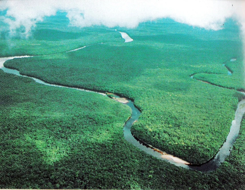
Mariusa National Park is best known for protecting one of the world's great river delta ecosystems, where the Orinoco River creates an expansive network of tidal channels, floodplain forests, and swamp environments. The park encompasses the unique Orinoco Delta swamp forests ecoregion, characterized by dense tropical vegetation, complex hydrological patterns driven by Atlantic tides, and extraordinary biodiversity found nowhere else on Earth. Its tidal jungles, which flood twice daily with Atlantic waters pushing through the delta channels, create a distinctive flooded forest landscape unlike any other protected area in the Americas.
Mariusa National Park history and protected-area timeline
Mariusa National Park was established on June 5, 1991, designated as a national park under Venezuelan protected area legislation with IUCN Category II classification. The park's creation reflected growing recognition of the Orinoco Delta's ecological significance and the need to preserve its unique wetland ecosystems from development pressures. Prior to formal protection, the delta region had long been inhabited by Warao communities whose traditional livelihoods centered on fishing, hunting, and sustainable use of the delta's resources. The establishment of the park formalized conservation of this extraordinary landscape while recognizing the Warao's ongoing connection to the territory. The park was originally referred to in some contexts as Delta del Orinoco National Park, though the official designation under Venezuelan law is Parque nacional Mariusa, reflecting the park's geographic core around Mariusa Island.
Mariusa National Park landscape and geographic character
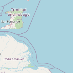
The landscape of Mariusa National Park is defined by its position within the Orinoco Delta, one of the world's great river delta systems. The terrain consists almost entirely of low-lying floodplain and swamp forest, intersected by an intricate network of distributary channels known locally as caños. These channels carry both the fresh waters of the Orinoco River system and the salt waters of the Atlantic Ocean, creating a unique tidal environment where saltwater intrudes far inland twice daily. The park encompasses both permanently flooded swamp areas and seasonal floodplain forests that inundate during the river's high water periods. The coastline along the Atlantic is punctuated by barrier islands including Mariusa Island, with Redonda Island representing the largest landmass within the park's floodable zone. The overall delta covers approximately 40,000 square kilometers and is fed by over 200 tributary rivers, creating a vast hydrological system that shapes every aspect of the landscape.
Mariusa National Park ecosystems, habitats, and plant life
The Orinoco Delta swamp forests protected by Mariusa National Park represent one of the most distinctive ecoregions in tropical South America. This wetland ecosystem is characterized by dense tropical forest adapted to either permanent or seasonal inundation, with trees and vegetation specifically adapted to the complex tidal hydrology. The interplay between freshwater river flow and Atlantic tidal influence creates a dynamic environment supporting specialized plant and animal communities. The delta's position at the interface between continental South America and the Caribbean Sea contributes to its biological significance, serving as a zone where species from multiple biogeographic origins converge. The park protects representative samples of this unique swamp forest ecosystem, preserving the ecological processes and biodiversity that define this remarkable corner of Venezuela.
Mariusa National Park wildlife and species highlights
The Orinoco Delta supports remarkable wildlife diversity within its tidal jungle and swamp forest environments. The flooded forest habitat provides critical habitat for numerous species adapted to the wetland conditions, including aquatic mammals, reptiles, and an extraordinary diversity of bird species. The delta's position along major migratory flyways makes it significant for neotropical bird populations, while its isolated jungle environment supports endemic species found nowhere else on Earth. The tidal channels harbor fish species important both ecologically and for local Warao fishing communities, while the forest canopy supports diverse mammal populations. The park's wildlife reflects the delta's unique position as a flooded forest environment where terrestrial and aquatic ecosystems intermingle in complex patterns shaped by the twice-daily tidal cycles.
Mariusa National Park conservation status and protection priorities
Mariusa National Park plays a critical role in preserving one of South America's most important wetland ecosystems. The Orinoco Delta swamp forests represent a globally significant ecoregion recognized for their ecological uniqueness and biodiversity value. The park's protection preserves not only the forest ecosystems but also the hydrological processes that sustain them, including the tidal dynamics that define the delta's character. Conservation of this area helps maintain the ecological integrity of the broader Orinoco Delta, which serves as a critical filter between the river system and the Atlantic Ocean. The park's designation as an IUCN Category II protected area reflects its primary conservation mandate while providing a framework for managing this remarkable wetland landscape.
Mariusa National Park cultural meaning and human context
The Mariusa National Park region is the ancestral homeland of the Warao people, indigenous communities who have inhabited the Orinoco Delta for generations. The Warao have developed intricate relationships with the delta's seasonal rhythms, tidal patterns, and abundant natural resources, building a culture deeply intertwined with the wetland environment. Their traditional livelihoods including fishing, hunting, and the use of forest resources are woven into the ecological fabric of the delta. The park exists within this living cultural landscape, where Warao communities continue to maintain connections to the territory even as formal protected area status restricts certain activities. The delta region represents one of the most culturally distinctive areas of Venezuela, where the rhythms of human life continue to follow the tidal cycles of the Orinoco.
Top sights and standout views in Mariusa National Park
Mariusa National Park protects a portion of one of the world's great river deltas, where the Orinoco River's vast network of channels meets the Atlantic Ocean. The park's tidal swamp forests, flooded twice daily by Atlantic waters pushing through the delta, create a flooded forest landscape found nowhere else on Earth. This is the most extensive delta in Venezuela and among the largest in the world, fed by over 200 tributary rivers and covering nearly 40,000 square kilometers. The park preserves the Orinoco Delta swamp forests ecoregion, a globally significant ecosystem of extraordinary biological uniqueness. Warao indigenous communities maintain traditional connections to this landscape, adding cultural depth to the ecological significance.
Best time to visit Mariusa National Park
The Orinoco Delta experiences distinct wet and dry seasons that affect visitor conditions and wildlife viewing opportunities. The dry season from approximately December through April typically offers easier navigation through the delta channels and more accessible wildlife viewing as higher ground remains above flood levels. During this period, the forest understory is less dense and water levels are lower, allowing better appreciation of the delta's intricate channel network. However, the wet season brings the delta to life in a different way, with the forest flooded across vast areas and the true character of this wetland ecosystem on full display. Each season reveals different aspects of the delta's complex ecology, though access to the park's remote interior remains challenging year-round.