
Mori Atlas logo
Nature reserveMehlinger Heide

Exploring the protected heath and sandy terrain within the Palatinate region of Germany

Mehlinger Heide Nature Reserve: Geographic Mapping of a Rare Southern German Heathland Mosaic

(Naturschutzgebiet Mehlinger Heide)

Mehlinger Heide stands as the largest inland heath landscape in southern Germany, providing a rare ecological contrast to the surrounding forested uplands of the Palatinate. This nature reserve features a distinct mosaic of open sandy patches, dry grassland, and low shrub heath that serves as a critical breeding area for ground-nesting birds. Originally shaped by historical land use and military activity, the area now offers a window into unique habitat recovery and protected geological diversity within Rhineland-Palatinate.

heathlandsandy heathdwarf-shrub heathdry grasslandinland dunesformer military training ground
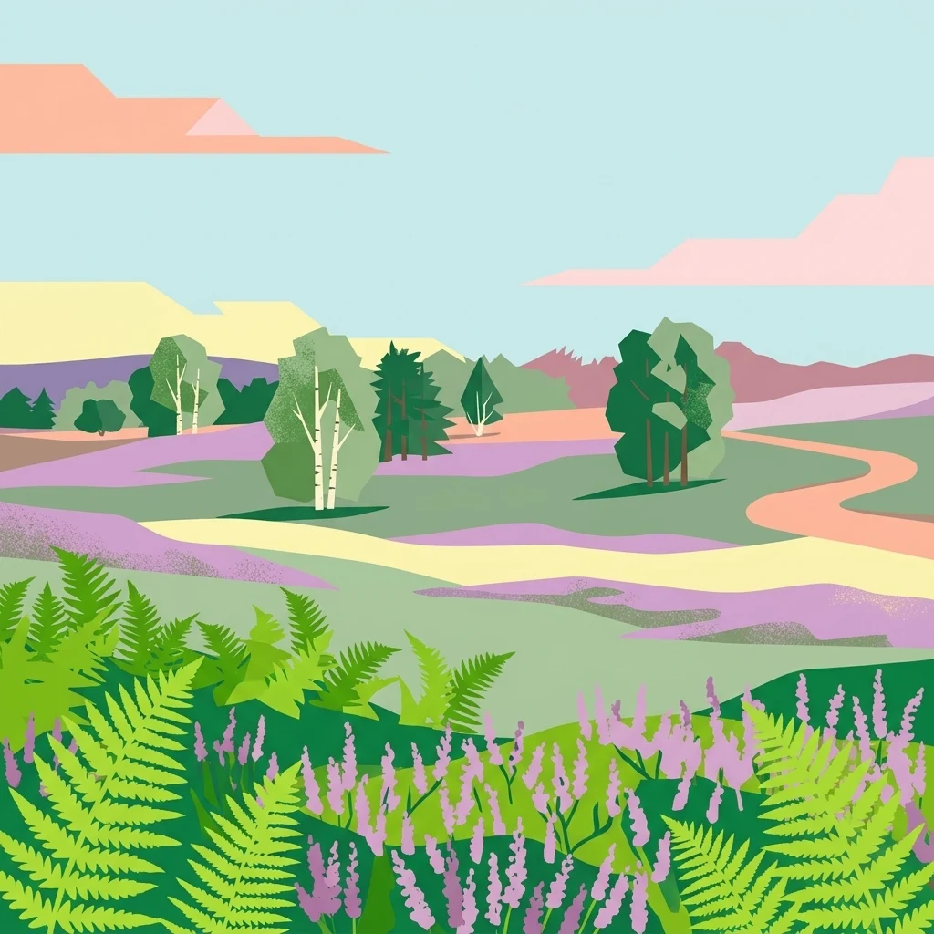
A digital illustration of the Mehlinger Heide landscape, featuring rolling hills of heathland, ferns in the foreground, scattered birch and pine trees, and a winding path under a pale blue sky.

Mehlinger Heide

Nature reserve

Park overview

Structured park overview, official facts, and landscape profile for Mehlinger Heide

Mehlinger Heide park facts, protected area profile, and essential visitor context

Review the core facts for Mehlinger Heide, including designation, size, terrain, visitor scale, habitats, and operating context in one park-focused overview.

About Mehlinger Heide

Mehlinger Heide is one of the southernmost large inland heath landscapes in Germany and a surprisingly distinctive natural area within the typically forested Palatinate region. Although the surrounding countryside of Rhineland-Palatinate is dominated by woodland, agricultural land, and the urban influence of Kaiserslautern, this protected area near Mehlingen preserves an open, sandy habitat mosaic that resembles the heathlands more typically associated with Lower Saxony or Schleswig-Holstein.

The protected nature reserve encompasses two main subunits, the Großer Fröhnerhof and the Kleiner Fröhnerhof, and spans parts of the municipal areas of Mehlingen, Baalborn, and Neukirchen. The active heathland component itself covers roughly 150 hectares, while the broader reserve is closer to 400 hectares, including surrounding woodland, transition zones, and small water bodies. Most of the open heath itself lies within the Gemarkung of Baalborn, which today falls within the city limits of Kaiserslautern through municipal reforms.

What makes the reserve unusual is the combined role of cultural history and ecological transformation. The site was originally forested, was shaped by centuries of marginal woodland use, and was then converted to an open military training ground whose repeated soil disturbance allowed heath vegetation and sandy pioneer habitats to develop. After the military returned the land in the early 1990s following the Cold War drawdown, the state recognised the conservation value of this unusual man-assisted landscape and moved to protect it formally.

Today Mehlinger Heide is recognised at both national and European level. It is classified under IUCN Category IV as a habitat and species management area and is part of the European Natura 2000 network through its designation as an FFH area. This layered recognition reflects the site's importance for threatened habitat types, including inland dune pioneer heaths, dry heaths with dwarf shrubs, and dry sandy grasslands, as well as for several protected species such as the nightjar, the woodlark, certain grasshopper species, butterflies, dragonflies, and rare hymenopterans. Access is regulated for both nature protection and safety reasons; the presence of residual munitions means visitors can only use two marked main paths, although a viewing platform on Höhe 325 provides a structural highlight that links the reserve architecturally to other regional conservation construction projects.

Quick facts and research context for Mehlinger Heide

Mehlinger Heide is a protected nature reserve in Rhineland-Palatinate, Germany, near the town of Mehlingen within the Landkreis Kaiserslautern. It is recognised as the largest heath landscape (Heidelandschaft) outside of northern Germany, with the active heath core covering about 150 hectares within a larger protected area of roughly 400 hectares.

The site was formally designated as a Naturschutzgebiet in 2001 and shortly afterwards, in 2006, confirmed as a European Flora-Fauna-Habitat (FFH) area, reflecting both national and European ecological significance. Its origins are deeply tied to former military training grounds; the transformation from dense forest to open heath was driven directly by prolonged troop activity during the twentieth century. The area is also under IUCN Category IV, classifying it as a habitat and species management area.

Protection and recognition

Documented terrestrial protection scope, designation history, and Natura 2000 records.

Mehlinger Heide Protection Status and International Recognition Data

Comprehensive protected area records for Mehlinger Heide outline the formal terrestrial protection status established in 2006. Documented international recognition data details official Natura 2000 designations associated with the protected landscape boundary.

International recognition

Protection details

Protection scope
Terrestrial
Designated year
2006
Transboundary protection
No
WDPA ID
318776
Park context

Deeper park guide and search-rich context for Mehlinger Heide

Mehlinger Heide history, landscape, wildlife, and travel context

Explore Mehlinger Heide through its history, landscape character, ecosystems, wildlife, conservation priorities, cultural context, and seasonal travel timing in a structured park guide built for atlas discovery and search intent.

Why Mehlinger Heide stands out

Mehlinger Heide is best known for being the largest inland heath landscape in southern Germany, an uncommon ecological phenomenon in a region more widely associated with forests than with open sandy heath. The reserve's defining feature is its mosaic of vegetation-free sandy patches, low shrub heath dominated by dwarf shrubs, drier grass communities, and scattered woodland edges, all of which represent habitat types that are otherwise scarce below central Germany. The site is also notable for the birdlife it supports, particularly ground-nesting species such as the woodlark (Heidelerche) and the nightjar (Ziegenmelker), both of which depend on the very open, early-succession landscapes that the meadow and heath mosaic provides. Together, these qualities establish Mehlinger Heide as one of the most ecologically unusual protected areas in Rhineland-Palatinate, despite its compact size and its location near significant former military sites.
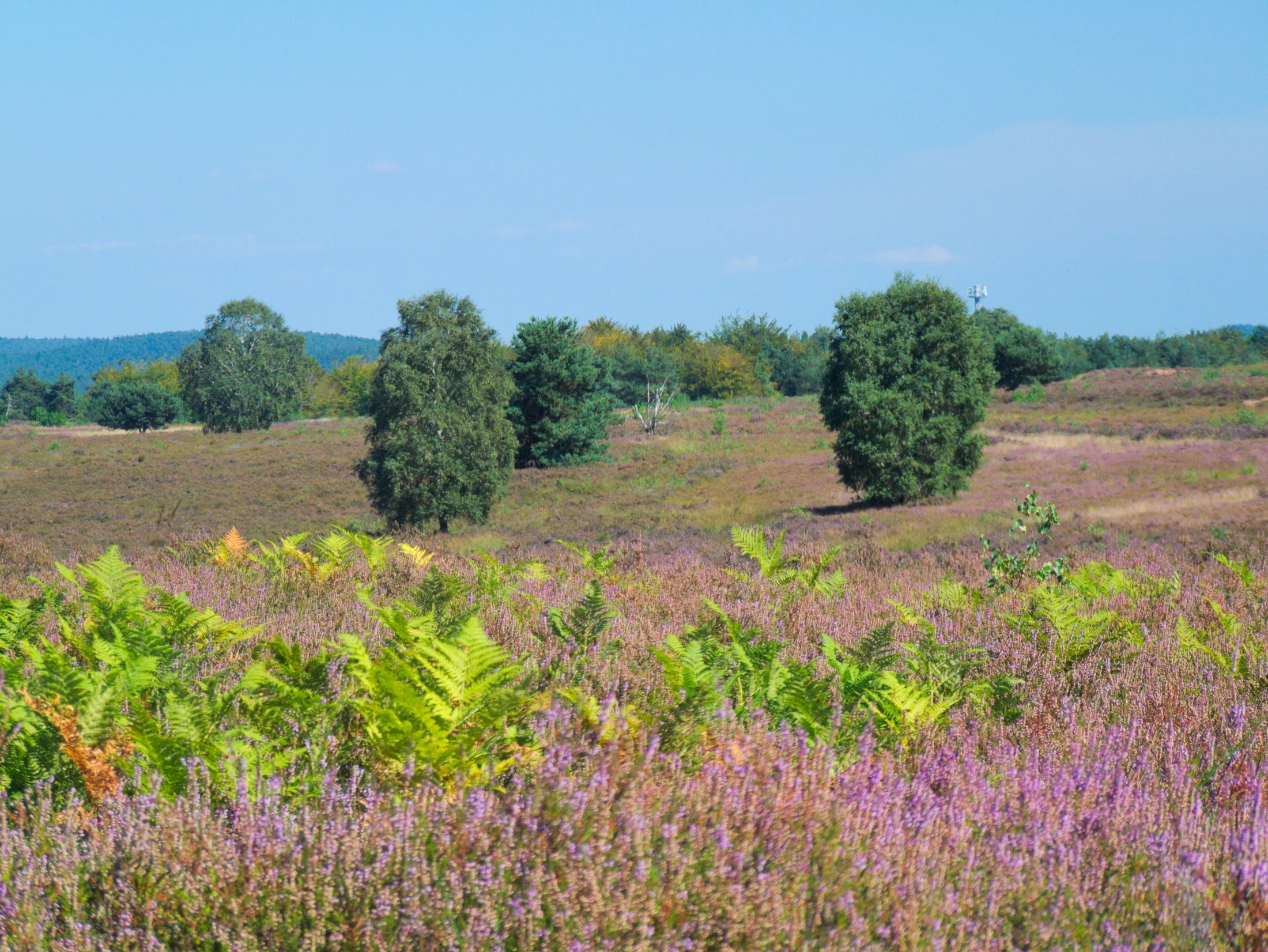
A wide view of the Mehlinger Heide heathland during the purple blooming season, featuring scattered green trees and bright green ferns in the foreground under a clear blue sky.
Purple heathland in bloom at the Mehlinger Heide nature reserve.

Mehlinger Heide history and protected-area timeline

The history of Mehlinger Heide is unusual because the protected landscape of today was not originally a heath but a forest. Up until 1912, the area around Mehlingen was fully covered with woodland. That woodland, however, was not used primarily for timber in a commercial sense; it fulfilled a range of rural, subsistence-style functions including collecting bedding material for livestock, grazing, gathering firewood, and harvesting pine cones for the regional seed kiln at Otterberg.

Historical records from the neighbouring community of Neukirchen describe this use as exploitative, with the local forestry office expressing concern that the woodlands were being over-harvested. A session record from 18 March 1886 notes how the Otterberg forestry administration had instructed its forest protection staff to record illegal extraction of heather and bedding material, and that offenders had been heavily fined, stirring significant local resentment. These pressures weakened the woodland over decades.

The decisive shift came in 1912, when a 92-hectare area at the Kleiner Fröhnerhof was transferred to the military administration in Kaiserslautern for use as a training ground. The community of Mehlingen offset the loss financially by selling oak and beech timber beforehand, gaining around 74,000 Reichsmark in the process. Military use of the area expanded further in 1937 when clearance began at the Großer Fröhnerhof, and regular troop exercises followed from 1938 onward. The constant mechanical disturbance of the soil and the removal of vegetation prevented forest regrowth and instead promoted open, sandy, dry conditions.

Parts of the area had already been used by the military during the First World War. After 1937, the Wehrmacht reactivated the site as a training ground; after 1945, French occupation forces took over, while U.S. forces used a portion of the area for surface-to-surface missiles of the MGM-13A Mace type and later for signal units, given the proximity of Ramstein Air Base and Sembach. After the Cold War ended, the French garrison was disbanded and the training ground handed back to Germany in 1992; U.S. areas followed in 1994.

Protective action came relatively quickly after the return of the land. In 1992, the Rhineland-Palatinate Ministry for the Environment began preparing the area for formal protection, recognising its special flora and fauna, communities that had developed as a direct result of military use. The designation of the Naturschutzgebiet took until 2001, partly because of routeing negotiations for the planned A63 motorway through the area. In 2006, the site was additionally recognised as an FFH (Fauna-Flora-Habitat) area under the European Union's Habitats Directive, integrating it into the broader European Natura 2000 network.

Mehlinger Heide landscape and geographic character

The landscape of Mehlinger Heide is a striking contrast to the wooded hill country that surrounds it. Although the Palatinate region is generally characterised by forested uplands, river valleys, and gentle agricultural slopes, the reserve itself is unusually flat to gently undulating, with sandy soils that support only sparse vegetation. The most prominent high point within the open area is known as Höhe 325, which also serves as the location of the reserve's main viewpoint.

The visible character of the reserve is defined by open sandy patches where wind and sun dominate, interspersed with dry grass communities, low shrub formations dominated by heather and related dwarf shrubs, and isolated pockets and edges of surviving woodland. This patchwork forms what ecologists describe as a habitat mosaic, providing different microclimates and successional stages across a relatively compact area. Small temporary pools and a single pond add further landscape variety, particularly for amphibians and insects.

The terrain also shows visible traces of its long use as a military training ground. Persistent soil disturbance prevented forest closure and helped maintain open, mineral-soil surfaces; the absence of dense tree cover allows the sandy substrate to dominate the visual impression. Combined with the proximity of larger settlements and the infrastructure of the former training ground, this gives the reserve an open, semi-natural character that reads more like a north German heath embedded within a central German landscape matrix.
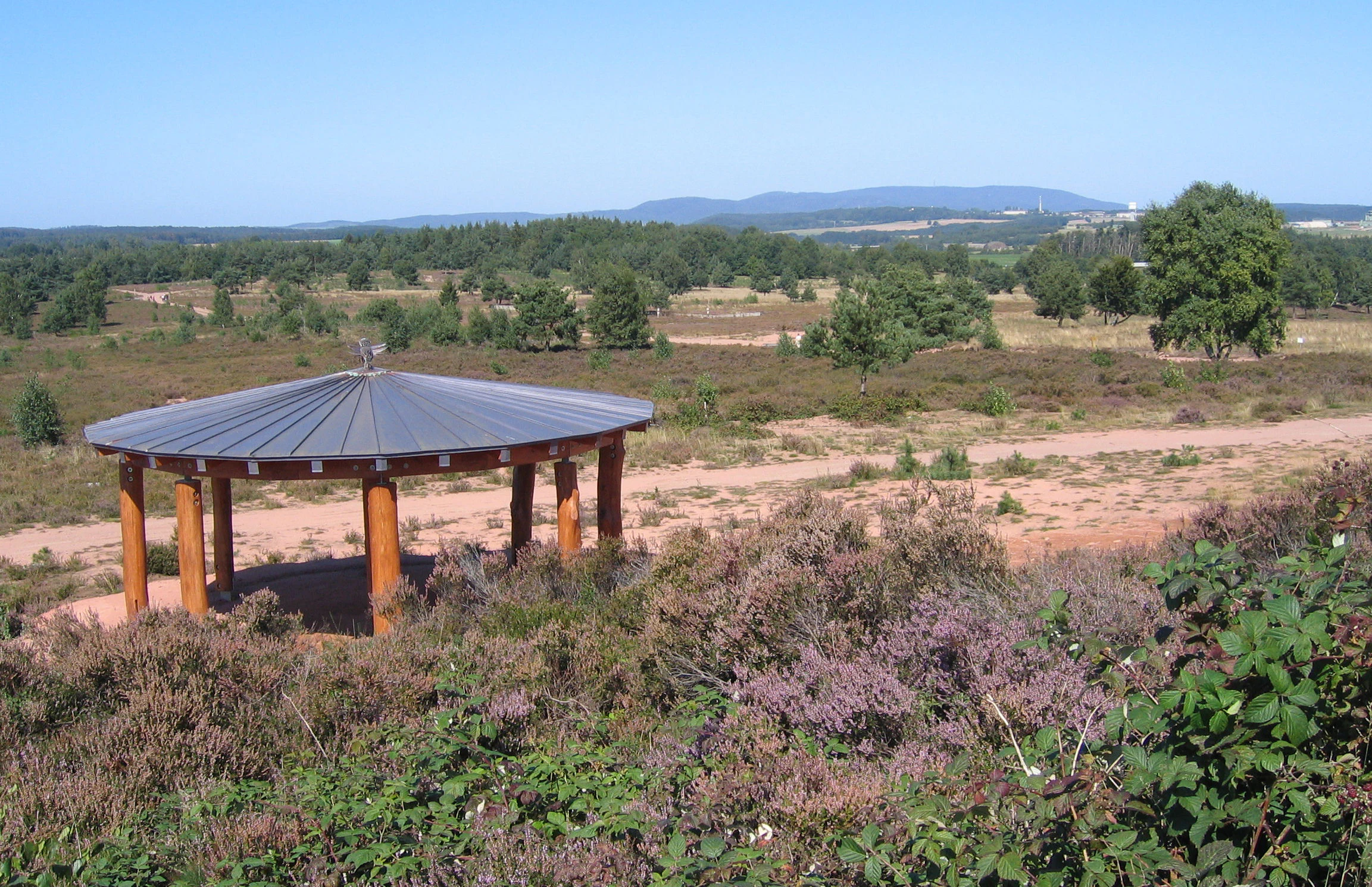
A circular wooden pavilion with a metal roof stands on a dirt path in a heathland area with purple heather, scattered trees, and distant hills under a clear blue sky.
A wooden pavilion overlooks the open heathland of Mehlinger Heide.

Mehlinger Heide ecosystems, habitats, and plant life

Ecologically, Mehlinger Heide is defined by a small set of habitat types that are focused on dry, acidic, sandy substrates. The reserve's formal conservation objectives include the protection of dwarf-shrub heaths, bent-grass dominated sandy grasslands, open sand surfaces and pioneer sand vegetation, dry acidic grasslands with open sand patches, and small temporary water bodies together with a single pond.

These habitats together reflect a classic early-succession inland dune ecosystem. The combination of exposed mineral soil, low vegetation height, scattered shrub patches, and small pools creates microclimates that are warm, dry, and exposed in summer, while remaining relatively mild in winter. The mosaic structure is important ecologically because different species groups depend on different stages of openness, from bare sand through low heather to grassy transitions.

A key conservation focus is the maintenance of this openness. Without periodic disturbance or active management, the sandy soils would eventually revert to forest, which is exactly the original condition that local records describe for the area before 1912. Active conservation management is therefore essential to keep sand pioneer habitats, dwarf-shrub heath, and associated dry grasslands in their current state. The reserve is also recognised under the EU Habitats Directive as an FFH area, placing its habitat protection within the broader European network of ecologically significant sites.

Mehlinger Heide wildlife and species highlights

Although Mehlinger Heide is a relatively compact site, its mosaic of open sand, dry grassland, and low shrub heath supports an unusually specialised fauna. Two bird species stand out in particular: the woodlark (Heidelerche) and the European nightjar (Ziegenmelker), both of which depend on the open ground, low vegetation, and warm microclimate that the heath provides. These two species are central to the reserve's formal conservation objectives, and the area is explicitly identified as an important breeding ground for them within the protected landscape.

Beyond the birds, the reserve is recognised for its invertebrate diversity, supported by the same set of habitats. The conservation designation specifically highlights rare grasshoppers, butterflies, hymenopterans, and dragonflies that depend on the dry sandy grassland, the temporary pools, and the pond within the former training ground. Beetles and other ground-dwelling invertebrates associated with bare sand and pioneer vegetation are also typical components of this type of inland heath ecosystem.

Larger mammal fauna is not the focus of the reserve, although common woodland and edge species are likely present along the wooded borders. The ecological value of the reserve lies less in charismatic megafauna and more in the combination of habitat-specialist birds, rare insects, and the ecological processes associated with open inland sand. These qualities give Mehlinger Heide significance disproportionate to its modest size within Rhineland-Palatinate's protected-area network.

Mehlinger Heide conservation status and protection priorities

From a conservation perspective, Mehlinger Heide is significant on multiple levels: national, regional, and European. At the national level, the site holds the status of a Naturschutzgebiet within the German nature protection framework, with the formal legal ordinance dating from 13 December 2001. This status imposes binding restrictions on land use and access, designed primarily to maintain the unusual habitat mosaic that developed as a legacy of former military activity.

At the European level, the reserve was confirmed as an FFH area (Fauna-Flora-Habitat-Gebiet) in 2006, integrating it into the Natura 2000 network and binding it to the habitat types listed under the EU Habitats Directive. These include inland dune pioneer heaths, dry heaths with dwarf shrubs, dry sandy grasslands, and dry acidic grasslands with open sand patches. The reserve is also classified under IUCN Category IV as a habitat and species management area, a category that recognises the need for ongoing active intervention to maintain the desired habitat structure against natural succession.

Conservation management at Mehlinger Heide is therefore intrinsically tied to preserving openness in a landscape that would otherwise revert to forest. The site also faces the unusual conservation constraint of residual munitions, which limits the type of management that can safely take place and restricts public access to two marked main paths. A viewing platform on Höhe 325 was nevertheless constructed to provide a structured point for visitors to appreciate the landscape, drawing design influence from the Biosphärenhaus in Fischbach. These features reflect a conservation strategy that balances habitat protection, public engagement, and safety.

Mehlinger Heide cultural meaning and human context

The cultural context of Mehlinger Heide is closely bound to the rural and military history of the Kaiserslautern region. Historically, the forests around Mehlingen, Baalborn, and Neukirchen were an integral part of the local subsistence economy, used for grazing, bedding collection, and firewood, with the woodland exertions documented in local protocols from the late nineteenth century. The transition of the area from community-managed forest to military training ground in the early twentieth century reflects a broader shift in land use across the Palatinate, particularly around Kaiserslautern, where several large training areas became permanent fixtures of the local geography.

The military footprint of Mehlinger Heide is not only ecological but also political and historical. The site was used successively by Imperial German forces, the Wehrmacht during the Second World War, French occupation troops after 1945, and U.S. forces during the Cold War, before being returned to Germany in stages during the early 1990s. Its return coincided with major geopolitical changes in Europe, and its repurposing as a nature reserve represents a notable example of a former militarised landscape in Germany being recast as a site of ecological value. The presence of the viewing platform and the Schaupfad (informational trail) also reflects how regional conservation authorities integrate such sites into local cultural and educational frameworks.

Top sights and standout views in Mehlinger Heide

Mehlinger Heide's main highlights are the unusually open sandy heath in a region better known for forest, the protected breeding habitat for woodlark and nightjar, and the small but valuable mosaic of dry grassland, dwarf-shrub heath, and pioneer sand vegetation. The viewing platform on Höhe 325 and the presence of a small pond and temporary pools further enhance the visitor experience, while the reserve's European FFH status reflects its importance to international conservation frameworks.

Best time to visit Mehlinger Heide

Mehlinger Heide is most visually distinctive in late summer and early autumn, when heath plants such as common heather typically come into bloom and the open sandy areas of the reserve are at their most colourful. The open ground and warm microclimate of the heath also increase the chances of encountering characteristic species such as grasshoppers, butterflies, and dragonflies during warmer months. Cooler months offer quieter conditions and clearer views across the open ground, while still providing access along the two marked paths. Visitors should be aware that access is restricted at all times for safety reasons due to residual munitions from the site's former use.


Monthly climate preview

Long-term representative temperature and precipitation patterns for Mehlinger Heide

Mehlinger Heide Climate Normals and Average Temperatures by Month

Historical data records the annual temperature progression and monthly precipitation rates measured at a representative coordinate within Mehlinger Heide. Reviewing the complete twelve-month climatology profile provides deeper analytical context for long-term regional weather patterns.
Annual mean10 °C
0 °C20 °C
Jan
Feb
Mar
Apr
May14°
Jun18°
Jul20°
Aug20°
Sep15°
Oct10°
Nov
Dec
Warmest month
July

20.4 °C

Coolest month
January

0.3 °C

Wettest month
July

2.2 mm/day

Driest month
April

1.4 mm/day

Park location guide

Geography guide, regional context, and park location map for Mehlinger Heide

Mehlinger Heide park geography, regions, and map view in Germany

Understand where Mehlinger Heide sits in Germany through a broader geographic reading of the surrounding landscape, nearby location context, and its mapped position within the national park landscape.

How Mehlinger Heide fits into Germany

Germany is a federal republic in Western and Central Europe with a population of over 83 million across sixteen constituent states. It is Europe's largest economy by nominal GDP and a major global exporter and importer. The capital is Berlin, and the country borders Denmark, Poland, Czech Republic, Austria, Switzerland, France, Luxembourg, Belgium, and the Netherlands.

Wider geography shaping Mehlinger Heide in Germany

Germany is located in Western and Central Europe, spanning 357,022 km². It borders Denmark to the north, Poland and the Czech Republic to the east, Austria and Switzerland to the south, and France, Luxembourg, Belgium, and the Netherlands to the west. The country has coastlines on the Baltic Sea and North Sea to the north, with the Alps located in the southern region.

Map view of Mehlinger Heide

Use this park location map to pinpoint Mehlinger Heide in Germany, understand its exact geographic position, and read its mapped placement within the surrounding landscape more clearly.

Pigeon | © OpenStreetMap contributors

Location context for Mehlinger Heide

Rhineland-Palatinate
Recorded earthquake history

Browse the Historical Catalogue of Seismic Activity for Mehlinger Heide

Investigate the documented history of seismic events recorded in the vicinity of Mehlinger Heide. Through the MoriAtlas collection, users can review event data, including magnitudes and epicentre locations, to understand the seismic context of this Rhineland-Palatinate nature reserve.

Mehlinger Heide Earthquake History

Catalogued events

12 events

Strongest magnitude

Magnitude 3.4

Most recent event

Dec 13, 2007

This history includes earthquakes recorded inside the park or within 50 km of its borders

Visualizing the sandy heath habitats and terrain of southern Germany

Mehlinger Heide Photos and Landscape Scenery Exploration

Photographic collections reveal the open sandy ground, dwarf shrub vegetation, and flat terrain defining this protected southern German heathland. Visual reference material helps observers understand the rare habitat mosaic and unique environmental character preserved within the Palatinate region.

A wide view of the Mehlinger Heide heathland during the purple blooming season, featuring scattered green trees and bright green ferns in the foreground under a clear blue sky.

A birch tree with white bark and green leaves stands in the center of an open heathland landscape under a clear blue sky.

A circular wooden pavilion with a metal roof stands on a dirt path in a heathland area with purple heather, scattered trees, and distant hills under a clear blue sky.

Park atlas

Discover related protected areas across the Palatinate region and southern Germany

Explore Parks Near Mehlinger Heide and Surrounding Protected Landscapes

Compare Mehlinger Heide with other regional nature reserves and protected areas located throughout the surrounding German landscape. Analyzing adjacent park geography provides a clearer picture of regional conservation patterns and habitat diversity.
Nature reserveRheinland-Pfalz
7.1 km away#1 closest

Southwest

Naturschutzgebiet Vogelwoog-Schmalzwoog: An Urban-Edge Wetland and Forest Mosaic in Germany

Protected nature reserve in the Rheinland-Pfalz region.

Naturschutzgebiet Vogelwoog-Schmalzwoog represents a significant micro-landscape characterized by the Vogelwoog lake and surrounding peat bogs. This protected area contains a dense concentration of ecosystems ranging from wet meadows to sand grasslands, showcasing the importance of small-scale conservation within the Hammerbach valley. Access map-driven details on the varied terrain that defines this unique Rhineland-Palatinate nature reserve.

Area
0.22 km²
Established
1996
Relief
Lowland
Climate
Temperate
A soft watercolor painting depicting a rolling landscape with fields, a small forest edge, and a mountain peak in the background.
Protected areaRhineland-Palatinate
8.5 km away#2 closest

North

Donnersberg Protected Area: A Geographic Atlas of the Palatinate Region's Highest Massif

Geological landscapes, Celtic heritage sites, and forested mountain terrain.

The Donnersberg massif represents a critical point of geographic and archaeological interest in Rhineland-Palatinate. This protected area encompasses a 24-square-kilometer rhyolite cryptodome featuring high-altitude plateaus, a complex network of forest ecosystems, and well-preserved remnants of ancient Celtic fortifications. Its steep slopes and diverse rock formations offer a clear look at the geological and historical layering of the German landscape.

Area
24 km²
Relief
Mountain
Climate
Temperate
Access
Easy access
Nature reserveRhineland-Palatinate
11 km away#3 closest

West

Westricher Moorniederung Nature Reserve: Protected Wetland and Moorland Atlas

Mapping low-lying basin landscapes and riparian corridors in the German Palatinate.

Spanning 40 kilometers between the Bliesaue and Kaiserslautern, the Westricher Moorniederung protects an intricate network of bogs, marsh zones, and alluvial forests. This lowland basin acts as a vital ecological link within Rhineland-Palatinate, defined by its drainage systems and diverse mire habitats. Gain insight into the regional geography and protected land boundaries that define this significant wetland system.

Area
21.52 km²
Established
1998
IUCN
IV
Nature reserveDonnersbergkreis
About 12 km away#4 closest

North

Beutelfels Nature Reserve: Geographic Insights and Protected Landscape Mapping

A diverse forested landmark in the Donnersbergkreis district

Located in the Falkensteiner Berge range, Beutelfels represents a significant protected area within the German landscape. The reserve showcases a dense integration of maple-linden forests and open rocky outcrops, preserved as a dedicated forest reference plot. Discover the unique topography and ecological zoning that define this essential 59-hectare segment of the Nordpfälzer Bergland.

Area
0.59 km²
Established
1981
Relief
Mountain
Climate
Temperate
Nature reserveRheinland-Pfalz
About 14 km away#5 closest

Southwest

Täler und Verlandungszone am Gelterswoog: Nature Reserve and Wetland Geography

A mosaic of lakes, mires, and stream valleys in Rheinland-Pfalz

Located in the Palatinate Forest, this protected nature reserve centers on the western shores of the Gelterswoog lake. It conserves a rare assembly of habitats including peat-forming moorland, reeds, and narrow forested valleys that provide essential breeding grounds for protected dragonfly species.

Area
0.554 km²
Established
1997
Nature reserveRheinland-Pfalz
About 15 km away#6 closest

Northeast

Spendel-Wildenstein Nature Reserve: Protected Forest Boundaries and Regional Geography

Deciduous forest reference area in the Donnersbergkreis district

Discover the geographic and ecological structure of Spendel-Wildenstein, a 145-hectare protected forest area in Germany. This nature reserve serves as a crucial natural forest reference site, known for its layered woodland communities, including rare Montpellier maple-oak and maple-ash stands situated along the Wildensteiner Bach stream valley.

Area
1.45 km²
Established
1981
Watercolor painting of a rolling landscape with green fields, forested hills in the distance, and soft hazy lighting.
Nature reserveRheinland-Pfalz
About 15 km away#7 closest

Southeast

Drachenfels Nature Reserve: Geography and Protected Landscapes of the Palatinate Forest

A sandstone summit and protected ecosystem in Rheinland-Pfalz

The Drachenfels massif is a classic blocky sandstone summit located in the Palatinate Forest, characterized by its 13-hectare protected summit plateau and weathered rock outcrops. This area provides a look into the region's complex sedimentary history, where Bunter sandstone cliffs meet dense forest slopes. The site serves as a distinct landmark within the broader landscape of the Middle Palatinate Forest, showcasing geological features and natural terrain patterns that define the local environment.

Area
0.125 km²
Established
1972
Relief
Mountain
Climate
Temperate
A soft, light watercolor painting of a rolling rural landscape featuring rows of vineyards in the foreground and tree-covered hills in the distance.
Nature reserveRheinland-Pfalz
16 km away#8 closest

East

Haardtrand Nature Reserve: Geographic Overview and Protected Landscape Mapping

Bird protection area within the Rheinland-Pfalz region.

Spanning roughly 14,700 hectares, Haardtrand serves as a critical link between the Palatinate Forest and the Rhine valley. This nature reserve is composed of a distinctive mosaic of habitat types, including mature broadleaf woodlands, traditional orchard meadows, and sandy terraces, which together create a highly structured environment for diverse raptors and forest-dwelling bird species.

Area
147.28 km²
Established
2004

Common questions about visiting, size, designation, and location context for Mehlinger Heide

Mehlinger Heide FAQs for park facts, access, geography, and protected area context

Find quick answers about Mehlinger Heide, including protected-area facts, park geography, trail and visitor context, and how the park fits into its surrounding country and regional landscape.
MoriAtlas Explorer

Continue Your Protected Areas Search Across the Global Atlas

Deepen your exploration by continuing the structured search for national parks and protected areas worldwide. Utilize the comprehensive filtering capabilities to compare different conservation landscapes and refine your understanding of global park geography. Discover more about the distribution and characteristics of protected natural areas.

Global natural geography