
Mori Atlas logo
Wildlife reserveMenagerie Wilderness

A detailed look at the protected rocky outcrops and dense coniferous landscapes of the central Oregon Cascades.

Menagerie Wilderness Wildlife Reserve: Mapping Cascade Range Pinnacles and Forest Terrain

Menagerie Wilderness stands as a distinctive protected area within the central Cascade Range of Oregon, defined by its unusual concentration of exposed rock pinnacles rising above a deep coniferous forest canopy. This atlas entry examines the rugged geography of the region, including the notable crags of Rooster Rock and Turkey Monster, while providing context on the steep creek drainages and forest matrices that characterize this section of the Willamette National Forest.

wilderness areaCascade Rangerock climbingrock pinnaclesconiferous forestDouglas-fir forest
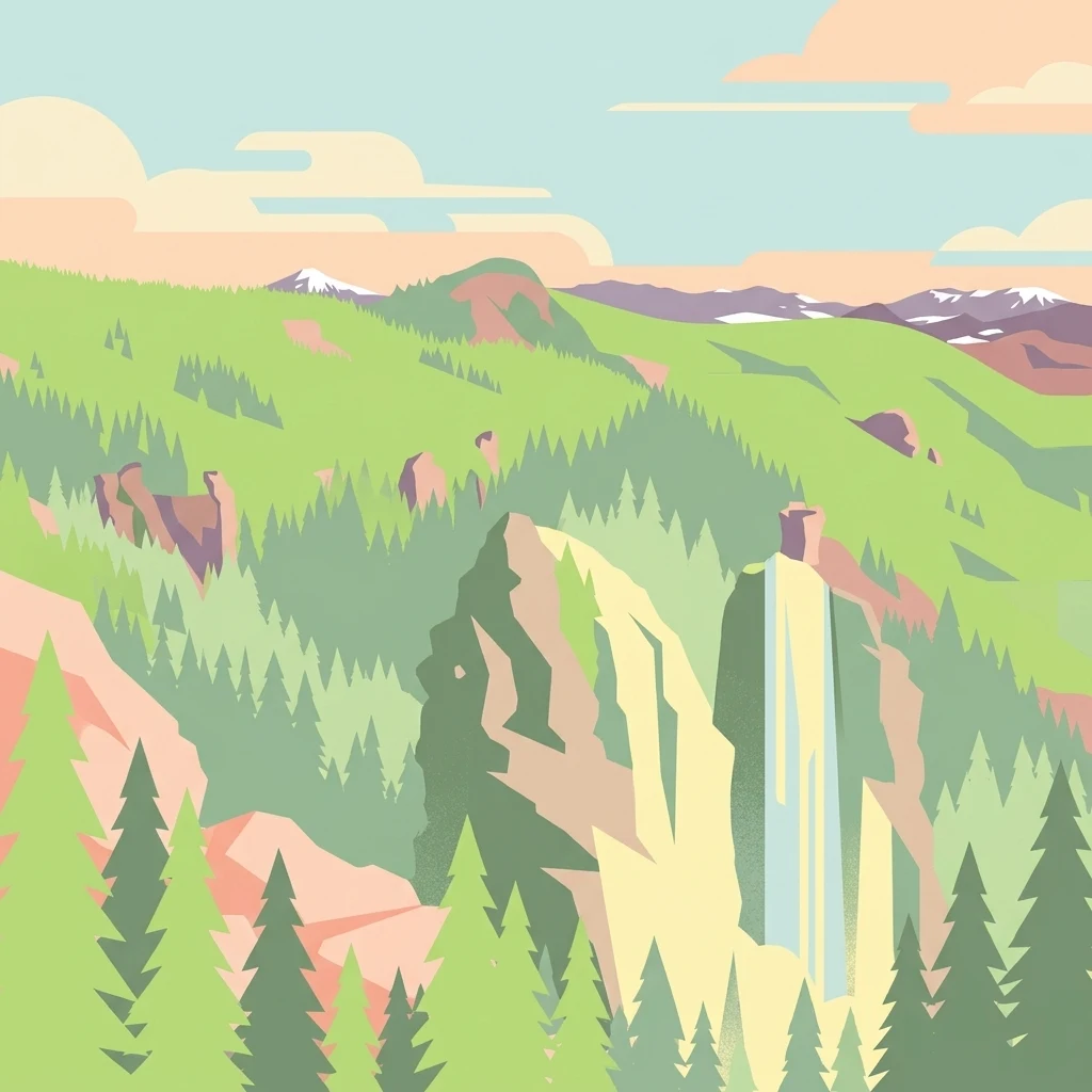
A flat-design, vector-style illustration of a mountainous wilderness scene with tall coniferous trees, steep rocky cliffs, and distant snow-capped mountains under a light sky.

Menagerie Wilderness

Wildlife reserve

Park overview

Structured park overview, official facts, and landscape profile for Menagerie Wilderness

Menagerie Wilderness park facts, protected area profile, and essential visitor context

Review the core facts for Menagerie Wilderness, including designation, size, terrain, visitor scale, habitats, and operating context in one park-focused overview.

About Menagerie Wilderness

Menagerie Wilderness occupies a modest but distinctive corner of the central Cascade Range in Oregon, where the volcanic geology of the range meets dense Willamette National Forest cover. Although it covers only a few thousand acres, the area is defined by its rocky pinnacles, which stand out as vertical interruptions in the surrounding sea of conifers and have shaped the wilderness's identity ever since.

The area's name comes directly from the imagination of past climbers, who assigned animal-themed names to the various pinnacles: Rooster Rock, Hen Rock, Turkey Monster, and Chicken Rock. This whimsical naming convention gave the area its collective identity and remains central to how the wilderness is described and experienced today. Rooster Rock is the most popular and recognizable of these formations, and the small but dedicated network of trails within the wilderness is largely oriented around reaching it.

In a broader sense, Menagerie Wilderness fits into Oregon's larger system of congressionally designated wilderness areas as a place where relatively compact terrain still provides a sense of solitude, ruggedness, and ecological integrity. Its central Cascade setting places it within an ecological transition between the wetter westside Cascades and the more open environments further east. The wilderness continues to serve as a low-key but valued destination for climbers, hikers, and visitors drawn to the Willamette National Forest's quieter corners.

Quick facts and research context for Menagerie Wilderness

Menagerie Wilderness is a federally designated Wilderness Area located in Linn County in Oregon's central Cascade Range, near the community of Sweet Home and not far from Mount Washington. Established in 1984 and administered by the U.S. Forest Service, it lies within the Willamette National Forest.

At a few thousand acres, it is among Oregon's smaller congressionally designated wilderness areas, but its compact footprint includes a defining cluster of named rock pinnacles rising from dense conifer forest. The wilderness is a popular destination for rock climbing and short to moderate hiking adventures, particularly routes that lead to the Rooster Rock area.

Protection and recognition

Examine documented terrestrial conservation parameters and international recognition frameworks

Menagerie Wilderness Protection Status and Territorial Designation Records

Menagerie Wilderness maintains a designated terrestrial protection scope within the global conservation network. Official records aggregate administrative designation details and international recognition parameters for analytical review.

Protection details

Protection scope
Terrestrial
Transboundary protection
No
Park context

Deeper park guide and search-rich context for Menagerie Wilderness

Menagerie Wilderness history, landscape, wildlife, and travel context

Explore Menagerie Wilderness through its history, landscape character, ecosystems, wildlife, conservation priorities, cultural context, and seasonal travel timing in a structured park guide built for atlas discovery and search intent.

Why Menagerie Wilderness stands out

Menagerie Wilderness is most widely known for its cluster of named rock pinnacles, a group of small but striking crags that give the area its "menagerie" character. Among these, Rooster Rock is the most familiar and attracts climbers from across the Pacific Northwest. Beyond the climbing appeal, the wilderness is recognized as a quiet forested complement to the higher, more heavily visited Cascade destinations nearby. It offers a combination of mossy old second-growth stands, steep drainages, and isolated rocky summits that reward visitors willing to leave the established trails.
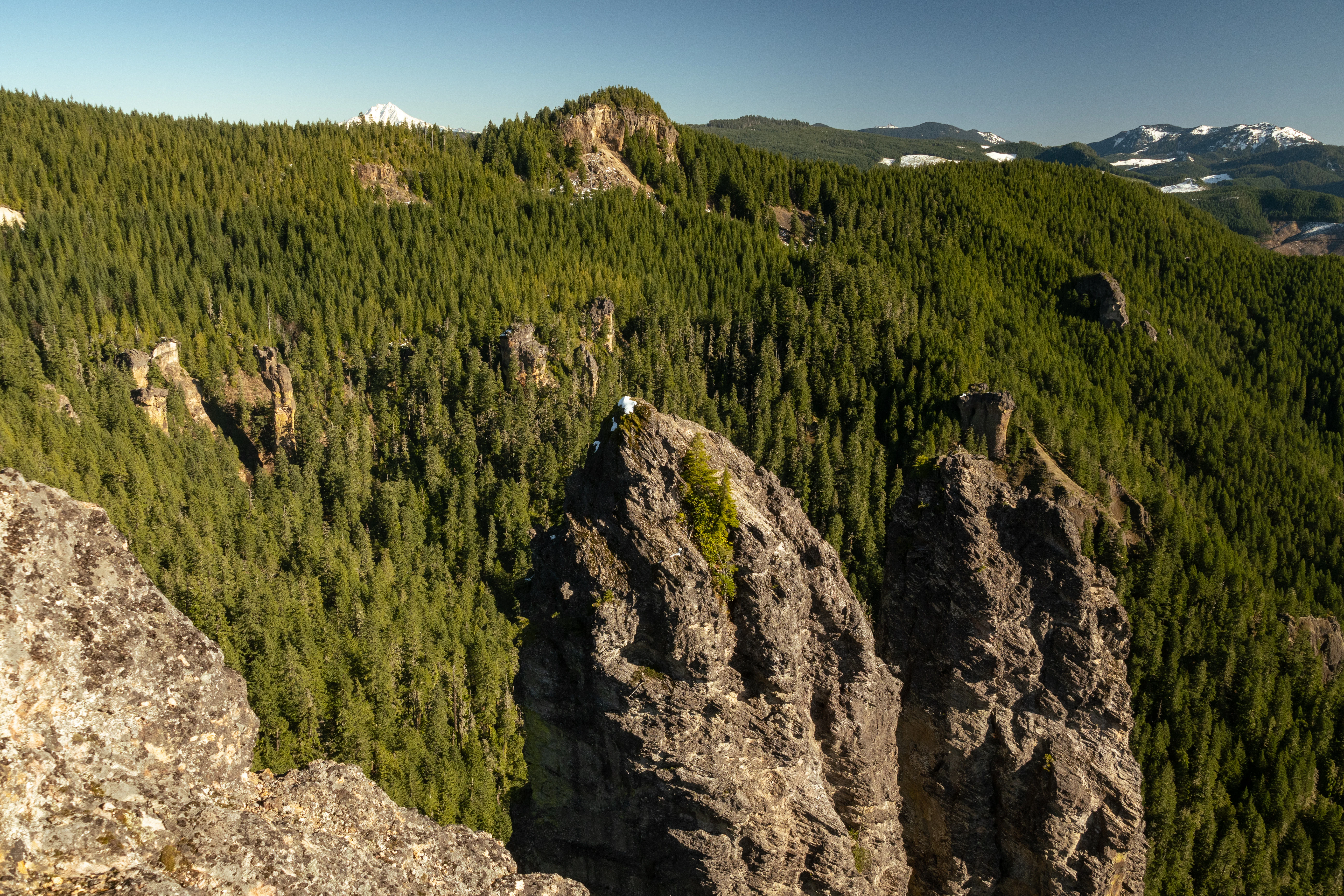
High-angle view of rugged volcanic rock spires rising from a dense coniferous forest in the Cascade Range, with distant snow-capped mountains visible on the horizon.
Prominent rock pinnacles rise above the dense evergreen forest canopy in the Menagerie Wilderness.

Menagerie Wilderness history and protected-area timeline

The Menagerie Wilderness received its federal wilderness designation in 1984, becoming part of Oregon's growing system of congressionally designated Wilderness Areas managed by the U.S. Forest Service. Its inclusion reflected the broader late-twentieth-century effort to formally protect representative examples of America's remaining wild landscapes under the Wilderness Act framework.

Before its designation, the area gained a quiet reputation among rock climbers who had begun exploring and naming the cluster of pinnacles that define the landscape. The adoption of animal-themed names for these formations gave the area its collective identity, and the climbing culture that emerged around these rocks helped establish the region as a distinctive destination within the Willamette National Forest.

Following designation, the area continued to be managed primarily for non-motorized recreation, ecological preservation, and its characteristic forested and rocky terrain. Although it is not among the most heavily visited wilderness areas in Oregon, it has retained a steady reputation among climbers and hikers who appreciate its combination of rugged pinnacles and quiet forest character.

Menagerie Wilderness landscape and geographic character

The physical landscape of Menagerie Wilderness is shaped by a distinctive combination of dense Cascade forest cover and an unusual concentration of exposed rocky pinnacles. The wilderness sits in a mid-elevation portion of the central Cascade Range, where volcanic geology, erosion, and forested slopes combine to create a setting with strong topographic relief in a relatively small area.

The defining landform is the cluster of crags collectively known as the Menagerie rocks. Rooster Rock is the most prominent and recognizable feature, while additional pinnacles such as Hen Rock, Turkey Monster, and Chicken Rock contribute additional vertical variety. These formations rise abruptly above the surrounding canopy, creating striking visual landmarks within an otherwise continuous forest matrix.

Beneath and around these pinnacles, the terrain is dissected by creeks and small drainages, most notably Keith Creek. Forest roads and trails give way to steep, cross-country ground outside of a few established paths, meaning much of the wilderness requires off-trail travel to fully explore. The overall scenery combines typical westside Cascade forest aesthetics with unexpected rocky prominence, giving the area a sense of scale and variety that exceeds what its modest size might suggest.

Menagerie Wilderness ecosystems, habitats, and plant life

Ecologically, Menagerie Wilderness lies within the moist, conifer-dominated zone characteristic of the central western Cascade Range. Its forests are predominantly composed of second-growth Douglas-fir along with western hemlock and western red cedar, reflecting the regeneration patterns of forests that have experienced past logging and natural disturbance in the region.

The understory is similarly typical of wet Cascade environments, with vine maple, salal, and sword fern forming familiar layered cover beneath the canopy. These species collectively create the shaded, mossy understory conditions that define much of the Willamette National Forest at mid-elevations.

Because the wilderness is relatively small and includes a notable percentage of exposed rock rather than continuous forest, it provides somewhat more habitat diversity than its acreage alone might suggest. The combination of forested slopes, rocky outcrops, and small creek drainages supports a mix of birdlife, small mammals, and the kind of quiet transitional habitat often found between productive forest and open rock environments.

Menagerie Wilderness wildlife and species highlights

Menagerie Wilderness supports wildlife typical of Oregon's moist central Cascades, including species commonly associated with mature and second-growth Douglas-fir forests. Deer, small forest mammals, and a variety of bird species inhabit the area, especially along the wooded corridors between drainages and ridge tops.

The mix of forested habitat and exposed rocky terrain provides foraging, roosting, and perching opportunities for raptors and other birds that favor edge environments between cliffs and canopy cover. This vertical and structural diversity contributes to a richer wildlife presence than the area's compact size might otherwise imply.

Because the wilderness is small and heavily visited by climbers and hikers at popular sites like Rooster Rock, wildlife observation tends to be concentrated away from those access points, where quieter forested and riparian zones offer better chances of seeing more sensitive forest species.

Menagerie Wilderness conservation status and protection priorities

Menagerie Wilderness holds conservation significance as a federally protected Wilderness Area under the U.S. Wilderness Act system. Its designation in 1984 secured long-term protection for its forested landscapes, rock formations, and ecological processes from development, roadbuilding, and other forms of intensive land alteration.

The wilderness contributes to the broader Willamette National Forest conservation network by preserving a sample of mid-elevation westside Cascade habitat, including characteristic coniferous forest communities, steep drainages, and unique rocky outcrops. Together, these features support ecological functions such as watershed protection, native vegetation maintenance, and habitat connectivity with adjacent forested lands.

While Menagerie Wilderness is smaller than many other federal wilderness areas in Oregon, its combination of forest cover and unusual rocky geology gives it distinct ecological value. Its protected status helps ensure that future generations will be able to experience a relatively undisturbed stretch of central Cascade terrain, including both the forest environment that surrounds the pinnacles and the pinnacles themselves.

Menagerie Wilderness cultural meaning and human context

Menagerie Wilderness has a notable climbing culture rooted in the imaginative naming of its rock pinnacles by early climbers. The tradition of assigning animal-themed names to each crag, from Rooster Rock to Chicken Rock, has become part of the area's identity and continues to influence how visitors relate to the landscape.

This light-hearted human imprint on the environment contrasts with the otherwise natural character of the surrounding Willamette National Forest, and it has helped the wilderness develop a small but recognizable following in Pacific Northwest outdoor recreation circles. Beyond this climbing heritage, the area does not have a prominent broader cultural history documented in major sources.

Top sights and standout views in Menagerie Wilderness

The standout quality of Menagerie Wilderness is its compact grouping of named rock pinnacles rising out of central Cascade forest. Rooster Rock, Hen Rock, Turkey Monster, and Chicken Rock collectively form a memorable climbing and hiking destination that is unique within the Willamette National Forest.

Equally important is the wilderness's quiet forested setting: dense Douglas-fir, western hemlock, and western red cedar cover, complemented by a familiar understory of vine maple, salal, and sword fern. For visitors, the wilderness delivers an appealing blend of distinctive rocky terrain and peaceful Cascade forest atmosphere, making it a worthwhile secondary destination for those exploring the central Oregon Cascades.

Best time to visit Menagerie Wilderness

Menagerie Wilderness is most pleasant to visit during Oregon's drier and warmer months, when the central Cascade trails and rocky approaches are less affected by snow and persistent rain. Late spring through early fall is typically the most favorable window for hiking and rock climbing, with stable weather, accessible trails, and better conditions for both forested exploration and time on the pinnacles.

In winter and early spring, the wilderness receives heavy precipitation and snowfall typical of the westside Cascades, which can make trail access more difficult and rock surfaces wet and cold. Visitors during shoulder seasons tend to encounter quieter conditions and lush, mossy forest scenery, though travel may require additional preparation for variable weather and rugged terrain.
Monthly climate preview

Track representative annual temperature ranges and monthly precipitation patterns across measured coordinates.

Menagerie Wilderness Climate Normals and Long Term Weather by Month

Menagerie Wilderness climate data records long term monthly averages for temperature and precipitation based on representative coordinate sampling from 1991 to 2020. Examining the complete twelve month profile provides deeper insight into annual meteorological rhythms across the protected landscape.
Annual mean9 °C
3 °C18 °C
Jan
Feb
Mar
Apr
May11°
Jun13°
Jul18°
Aug18°
Sep16°
Oct10°
Nov
Dec
Warmest month
August

18.3 °C

Coolest month
December

2.7 °C

Wettest month
December

8.3 mm/day

Driest month
July

0.5 mm/day

Park location guide

Geography guide, regional context, and park location map for Menagerie Wilderness

Menagerie Wilderness park geography, regions, and map view in United States of America

Understand where Menagerie Wilderness sits in United States of America through a broader geographic reading of the surrounding landscape, nearby location context, and its mapped position within the national park landscape.

How Menagerie Wilderness fits into United States of America

The United States of America is a federal presidential republic and one of the world's largest countries by area and population. It consists of 50 states across a vast territory spanning multiple time zones, with its capital in Washington, D.C. and largest city in New York City. The nation has a diverse economy, influential political system, and significant cultural and military presence globally.

Wider geography shaping Menagerie Wilderness in United States of America

The United States occupies a vast territory in North America, bordered by Canada to the north and Mexico to the south. The 48 contiguous states stretch from the Atlantic to the Pacific Ocean, while Alaska occupies the northwestern region and Hawaii is an archipelago in the Pacific. The country encompasses diverse terrain including the Rocky Mountains, Appalachian Mountains, Great Plains, and extensive river systems.

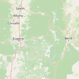
Map view of Menagerie Wilderness

Use this park location map to pinpoint Menagerie Wilderness in United States of America, understand its exact geographic position, and read its mapped placement within the surrounding landscape more clearly.

Pigeon | © OpenStreetMap contributors

Location context for Menagerie Wilderness

Oregon

Visual reference for rugged rock pinnacles and dense coniferous forest habitats

Menagerie Wilderness Photos and Scenery: Exploring Cascade Rock Formations

Visual documentation captures the dramatic contrast between exposed volcanic rock pinnacles and continuous coniferous forest across the protected terrain. Examining these detailed landscape photographs provides a clearer understanding of the unique topographic relief and protected habitat character found throughout the region.

High-angle view of rugged volcanic rock spires rising from a dense coniferous forest in the Cascade Range, with distant snow-capped mountains visible on the horizon.

A rock climber hangs from a rope on the side of a tall, dark stone pinnacle, while another person sits on top of the formation; green trees and distant mountain ridges are visible in the background.

Park atlas

Compare surrounding Cascade Range reserves and forested wilderness areas

Parks Near Menagerie Wilderness and Related Protected Landscapes in Oregon

Browse protected areas near Menagerie Wilderness to compare regional terrain, dense coniferous forests, and exposed rocky pinnacles across the central Cascade Range. Continuing into adjacent forest reserves helps connect individual climbing crags with the wider geography of Oregon protected lands.
Protected landscapeOregon
Mapped location lies within the park boundary#1 closest

South

Willamette National Forest: Geography and Protected Landscapes of the Central Oregon Cascades

Mapped terrain, old-growth forests, and protected wilderness boundaries.

Explore the expansive territory of Willamette National Forest, a primary protected area extending over 100 miles along Oregon's Cascade Range. This region features volcanic peaks exceeding 10,000 feet, extensive old-growth Douglas-fir stands, and a dense network of Wild and Scenic rivers, providing a detailed look at the geographic character and ecological heritage of the Pacific Northwest.

Area
6,790.75 km²
Established
1933
Visitors
1.7M annual
Relief
Mountain
Wildlife reserveOregon
About 9.1 km away#2 closest

North

Middle Santiam Wilderness: Geographic Atlas and Protected Landscape Overview of the Oregon Cascades

Old-growth forest basins and volcanic landmarks in the Willamette National Forest.

Middle Santiam Wilderness represents a distinct segment of the central Oregon Cascades. The area is defined by its substantial old-growth coniferous forests, including 450-year-old Douglas-fir and western hemlock stands, alongside the striking 4,965-foot volcanic plug known as Chimney Peak. This map-focused record traces the river-cut valleys and high-ridge topography that shape this protected habitat.

Area
34.57 km²
Established
1984
IUCN
Ib
Relief
Mountain
A horizontal watercolor illustration showing a landscape with soft rolling mountains in the distance, a line of pine trees in the midground, and a grassy shoreline in the foreground.
Wildlife reserveOregon
About 27 km away#3 closest

East

Mount Washington Wilderness: Volcanic Geology and Forested Cascade Terrain

A mapped overview of Oregon protected volcanic landscapes.

Mount Washington Wilderness offers a stark and compelling geological study of Oregon's central Cascades. From the shield volcano's basaltic remnants to the fragmented cinder cones of Belknap Crater, the area provides a window into explosive and effusive volcanic activity. Our geographic data maps the transition of conifer forests and subalpine zones across its rocky, lake-dotted interior, highlighting the unique character of this quiet protected preserve.

Area
219.66 km²
Established
1964
IUCN
Ib
Relief
Mountain
A watercolor painting showing a snowy mountain peak in the background rising above rolling green hills and pine forests in the foreground.
Protected landscapeOregon
About 45 km away#4 closest

Northeast

Mount Hood National Forest: Atlas of Protected Landscapes and Volcanic Geography

Exploring the Cascade Range terrain and wilderness boundaries in Oregon.

Mount Hood National Forest encompasses a vast, rugged expanse of the Oregon Cascades, anchored by the iconic, glacier-clad Mount Hood. This protected landscape contains extensive old-growth forests, high-alpine lakes, and deep river canyons. Discover the geographic extent of these wilderness areas and mountain terrain within the MoriAtlas database of protected lands.

Area
4,318.17 km²
Established
1908
Visitors
4.4M annual
Relief
Mountain
Watercolor painting of a coastal landscape with sandy dunes, beach grasses in the foreground, and a dense treeline in the background.
Protected landscapeOregon
About 77 km away#5 closest

West

Siuslaw National Forest: Oregon Coast Range and Protected Landscape Geography

Coastal dunes, temperate rainforests, and river networks

Explore the mapped boundaries and natural geography of Siuslaw National Forest. This protected landscape highlights the ecological transition from Pacific shorelines to the high-elevation forests of the Oregon Coast Range, encompassing sand dune systems, salmon-supporting streams, and significant wilderness refuges.

Area
2,566.54 km²
Established
1908
Visitors
1M annual
Climate
Temperate
Wildlife reserveOregon
About 92 km away#6 closest

North

Roaring River Wilderness: Geography and Protected Area Atlas of Oregon

Ancient forest corridors and alpine lake landscapes

Roaring River Wilderness is a federally protected landscape in Oregon, defined by steep, tree-covered ridges and the vigorous Roaring River. This wilderness preserves a dense mosaic of old-growth conifers, high-elevation alpine lakes like Serene and Shellrock, and important salmon-spawning waters within the broader Mount Hood National Forest geography.

Area
148 km²
Established
2009
IUCN
Ib
Relief
Mountain
Protected landscapeOregon
About 100 km away#7 closest

Northeast

Mount Hood National Recreation Area: Oregon Protected Landscape and Regional Geography

A three-unit recreational forest landscape in the Cascade Range.

Spanning over 34,000 acres, this protected landscape frames the lower volcanic slopes and forested drainages around Mount Hood. The area integrates river corridors, wilderness boundaries, and subalpine terrain, offering a clear view of the complex topography that defines the Cascade Range in northern Oregon.

Area
139.8 km²
Established
2009
Relief
Mountain
Climate
Temperate
A watercolor painting showing a wide, panoramic view of a mountain range in the background, rolling green hills in the midground, and a small cluster of evergreen trees in the foreground against a white background.
Wildlife reserveOregon
About 100 km away#8 closest

North

Mount Hood Wilderness: Atlas of Volcanic Peaks and Glacial Geography in Oregon

High-altitude protected landscapes and forest ecosystems

This protected area captures the dramatic character of the Cascade Range through its signature volcanic terrain, ancient forests, and high-alpine ridges. Covering a vast vertical range, the wilderness offers a study in geologic forces, featuring active glaciers, deep basaltic canyons, and meadows that define the mountain's northern and western slopes.

Area
262 km²
Established
1964
IUCN
Ib
Visitors
10K annual

Common questions about visiting, size, designation, and location context for Menagerie Wilderness

Menagerie Wilderness FAQs for park facts, access, geography, and protected area context

Find quick answers about Menagerie Wilderness, including protected-area facts, park geography, trail and visitor context, and how the park fits into its surrounding country and regional landscape.
MoriAtlas Explorer

Continue Your Protected Areas Search Across the Global Atlas

Deepen your exploration by continuing the structured search for national parks and protected areas worldwide. Utilize the comprehensive filtering capabilities to compare different conservation landscapes and refine your understanding of global park geography. Discover more about the distribution and characteristics of protected natural areas.

Global natural geography