Mori Atlas logo
Protected landscapeWillamette National Forest

Tracing volcanic peaks, glacial valleys, and the extensive old-growth forests of the central Cascade Range.

Willamette National Forest: A Comprehensive Atlas of Oregon's Protected Cascade Mountain Landscapes

Willamette National Forest spans the western slopes of Oregon's central Cascade Range, representing a vast protected landscape of high-elevation volcanic summits, deeply carved river canyons, and dense temperate coniferous forests. This expanse contains seven major Cascade peaks, hundreds of alpine lakes, and critical headwaters within a complex network of designated wilderness areas. By mapping these features, it becomes possible to understand the geological and environmental significance of this critical Pacific Northwest protected area.

national forestCascade Rangeold-growth forestDouglas-firwilderness areasWild and Scenic rivers

Willamette National Forest

Protected landscape

Park overview

Structured park overview, official facts, and landscape profile for Willamette National Forest

Willamette National Forest park facts, protected area profile, and essential visitor context

Review the core facts for Willamette National Forest, including designation, size, terrain, visitor scale, habitats, and operating context in one park-focused overview.

About Willamette National Forest

Willamette National Forest is one of the largest and most ecologically significant national forests in the Pacific Northwest. It lies in the central portion of the Cascade Range and extends roughly 100 miles along the western slope of the Cascades, from the Mount Jefferson area east of Salem southward to the Calapooya Ridge, which marks the divide between the Willamette and Umpqua watersheds. The forest spans Lane, Linn, Marion, and Douglas counties, with smaller portions reaching into Clackamas and Jefferson counties.

The landscape ranges from about 1,500 feet at the western edge of the forest to nearly 10,500 feet at the summit of Mount Jefferson, Oregon's second-highest peak. Seven major volcanic Cascade summits sit within its wilderness areas: Mount Jefferson, Mount Washington, Three Fingered Jack, Diamond Peak, and the North, Middle, and South Sisters. Between these high peaks and lower valleys flow rivers such as the McKenzie and the North Fork Middle Fork Willamette River, both protected under the National Wild and Scenic Rivers System.

The forest is known for towering old-growth Douglas-fir, an exceptionally wet climate fueled by Pacific storms, and an unusually dense network of rivers, streams, and lakes. Together these features have made Willamette National Forest both a productive timber landscape and one of the most important strongholds of native Cascade ecosystems in Oregon. It is also the headwaters region of the Willamette River, the namesake of the forest itself.

In addition to its wilderness, the forest contains campgrounds, ranger districts, historic ranger stations, and a long tradition of recreational use, timber management, mining, and conservation. Its modern identity reflects a balance, sometimes contested, between extractive use and the protection of old-growth forest, salmon-bearing streams, and sensitive wildlife.

Quick facts and research context for Willamette National Forest

Willamette National Forest is located in western Oregon, primarily on the western slopes of the central Cascade Range. It covers roughly 1.6 million acres and is overseen by the United States Forest Service, with headquarters in Springfield and ranger districts in McKenzie Bridge, Detroit, Sweet Home, and Westfir.

Nearly a quarter of the forest is protected as designated wilderness, and the forest includes major Cascade peaks, old-growth Douglas-fir stands, Wild and Scenic rivers, and a network of hundreds of lakes. Its rivers supply high-quality drinking water to several of Oregon's largest cities, and it is closely associated with the northern spotted owl controversy and the Northwest Forest Plan.

Protection and recognition

Documented terrestrial protection scope and historical designation data

Willamette National Forest Protection Status and Designation History

Willamette National Forest maintains a documented terrestrial protection status established in nineteen thirty three. Structured conservation records provide historical designation details and management scope for geographic analysis.

Protection details

Protection scope
Terrestrial
Designated year
1933
Transboundary protection
No
Park context

Deeper park guide and search-rich context for Willamette National Forest

Willamette National Forest history, landscape, wildlife, and travel context

Explore Willamette National Forest through its history, landscape character, ecosystems, wildlife, conservation priorities, cultural context, and seasonal travel timing in a structured park guide built for atlas discovery and search intent.

Why Willamette National Forest stands out

Willamette National Forest is best known for its extensive old-growth Douglas-fir forests, which include some of the tallest trees in the world, and for its seven major Cascade peaks, including Mount Jefferson and the Three Sisters. It is also recognized for its network of National Wild and Scenic Rivers and its large system of designated wilderness, which together protect prime examples of the Pacific Northwest's temperate coniferous landscape. The forest is equally famous, if more controversially, as a focal point of the late twentieth-century conflict between timber harvesting and the protection of old-growth ecosystems, particularly the habitat of the northern spotted owl.
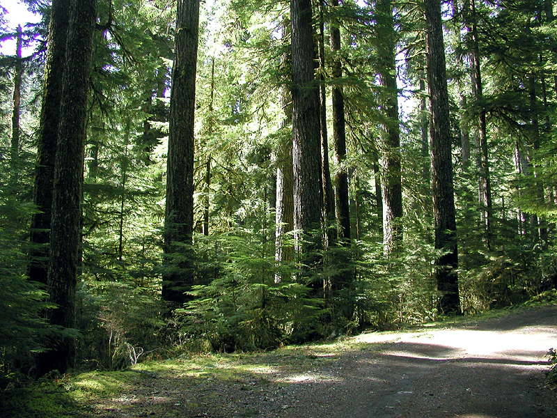
A dirt trail winds through a dense old-growth forest with tall, mature evergreen trees and dappled sunlight.
Old-growth forest path in the Opal Creek Wilderness.

Willamette National Forest history and protected-area timeline

The history of Willamette National Forest stretches back to 1893, when President Grover Cleveland created the Cascade Forest Reserve in response to petitions from local citizens seeking to protect the Cascade Range. At first, the reserve was largely managed as a preserve.

In 1897, the Sundry Civil Appropriations Act, often called the Organic Act, supplied funding for managing the reserves and instructed the government to secure favorable water flows, provide a continuous supply of timber, protect forests from fire, and develop mineral resources. This legislation shaped the management of the Cascade forests for decades to come and led to the appointment of early rangers such as Addie Morris and Cy Bingham in what would become the Willamette.

Between 1908 and 1933, the original Cascade Forest Reserve was broken up into several smaller national forests, including the Oregon National Forest, Cascade National Forest, Umpqua National Forest, Crater National Forest, and Santiam National Forest. In 1933, the Santiam and Cascade national forests were merged into today's Willamette National Forest.

During the Great Depression and World War II, the forest became an important federal presence in western Cascades communities. The Civilian Conservation Corps carried out land improvement and employment projects, sustained-yield forestry was promoted, and wartime demand pushed log production sharply upward, with hundreds of millions of board feet of timber sold between 1942 and 1945.

The postwar period brought more intensive management, rapid growth in recreation, campground construction, dam building, and wildlife programs. Major storms and floods, especially the Columbus Day Storm of 1962 and the Christmas floods of 1964, caused severe damage to timber and campgrounds. The Wilderness Act of 1964 and the rise of the environmental movement added new debates over forest use, culminating in the French Pete controversy around the Three Sisters Wilderness.

From the 1970s onward, the forest was at the center of the national debate over old-growth logging and the northern spotted owl. The Northwest Forest Plan of 1993 reshaped logging levels and habitat protections across the region, including Willamette National Forest, marking a new era of more constrained but still ongoing forest management.

Willamette National Forest landscape and geographic character

Willamette National Forest stretches along the western slope of Oregon's central Cascade Range, where volcanic peaks, glacial valleys, and deeply forested river canyons define the terrain. Elevations climb from around 1,500 feet along the western edge of the forest to nearly 10,500 feet at the summit of Mount Jefferson.

Seven major Cascade peaks rise within the forest's wilderness areas: Mount Jefferson, Mount Washington, Three Fingered Jack, Diamond Peak, and the North, Middle, and South Sisters. Between and around these summits sit hundreds of lakes, mountain meadows, lava fields, and rugged ridges shaped by volcanic and glacial processes.

The forest is also defined by its rivers, including the McKenzie, the Santiam, and the headwaters of the Willamette itself, which carve valleys through the Cascades. Streams, tributaries, and small alpine lakes spread across the high country, while mature coniferous forests cloak the lower slopes, creating the layered scenery the Willamette is known for.

Willamette National Forest ecosystems, habitats, and plant life

The Willamette's natural environment reflects the wet, mild influence of the Pacific Ocean colliding with the cold, high elevations of the Cascades. Annual precipitation commonly ranges from 80 to 150 inches, much of it falling as snow at higher elevations between October and April. This moisture feeds the dense forests, rushing rivers, and rich salmon streams of the region.

The defining vegetation is old-growth and mature Douglas-fir forest, the state tree of Oregon, with some individual trees exceeding 300 feet in height. Alongside Douglas-fir grow western redcedar, incense-cedar, western white pine, ponderosa pine, Pacific yew, western and mountain hemlock, and several fir species, producing a richly layered coniferous ecosystem. Across the forest, ecosystems shift from low-elevation western forests to montane and subalpine communities near the high volcanic peaks.

Roughly 380,000 acres of the forest are designated wilderness, protecting old-growth stands, headwater habitats, and high-elevation environments from development. More than 1,500 miles of rivers and streams weave through the terrain, providing habitat for migratory fish and connecting the forest to downstream agricultural and urban communities.

Willamette National Forest wildlife and species highlights

Willamette National Forest supports a wide variety of Pacific Northwest wildlife across its elevation gradient. Large mammals include Roosevelt elk, mule deer, black-tailed deer, American black bear, and the elusive North American cougar. Predators and uncommon carnivores such as the wolverine also occur in the more remote wilderness terrain.

The forest's rivers and streams are especially important for fish. Cold, clean waters support Chinook salmon and bull trout, while smaller streams host native species that depend on intact forest cover for shaded, stable habitat. More than 300 species of fish and wildlife have been documented in the forest.

Birdlife and smaller fauna thrive in the dense old-growth and mixed conifer stands. Species of particular conservation interest include the northern spotted owl and the bald eagle, while smaller mammals such as the southern red-backed vole inhabit the mossy understory. Together these species make the Willamette one of the most biologically rich national forests in the lower 48 states.

Willamette National Forest conservation status and protection priorities

Willamette National Forest holds enormous conservation significance as one of the largest remaining strongholds of old-growth Douglas-fir forest in the Pacific Northwest. It contains hundreds of thousands of acres of old growth, including some of the tallest individual trees in the world, and it is a key habitat area for species that depend on ancient forest structure.

The forest has been central to the late twentieth-century debate over old-growth logging and the protection of endangered species, especially the northern spotted owl. Environmental groups argued that aggressive clearcutting was destroying critical habitat, while the timber industry emphasized the forest's role as a jobs and timber resource. The Northwest Forest Plan, adopted in 1993, set a new framework for managing the Willamette and other regional forests, limiting but not eliminating logging in potential spotted owl habitat.

Beyond spotted owl protection, the forest's wilderness system, Wild and Scenic rivers, watershed functions, and drinking-water contributions to cities such as Eugene, Salem, Corvallis, and Albany make it a landscape of broad conservation, hydrological, and ecological value.

Willamette National Forest cultural meaning and human context

The Willamette National Forest region carries a long human history of resource use and community identity. Early cascades missions, mining, and logging communities shaped much of western Oregon, and the forest remains closely tied to nearby towns such as Oakridge, Sweet Home, Detroit, and Springfield.

The creation of the Cascade Forest Reserve in 1893 reflected growing local concern about protecting the Cascade Range, and the early twentieth century brought federally organized ranger patrols, fire control, and recreation planning into the area. The Civilian Conservation Corps later left a legacy of trails, structures, and improved public access during the Great Depression.

The more recent cultural significance of the forest is tied to the broader Pacific Northwest debate over land use. Timber, environmental advocacy, recreation, and indigenous and rural community connections have shaped competing visions of what the Willamette should be, making the forest a key cultural landscape in modern Oregon identity.

Top sights and standout views in Willamette National Forest

Willamette National Forest's most distinctive features include its old-growth Douglas-fir stands, with some trees over 300 feet tall, and its seven designated Cascade peaks that define the high skyline. Approximately a quarter of the forest is designated wilderness, anchored by large blocks such as the Three Sisters and Mount Jefferson wildernesses.

The forest is also home to several rivers protected under the National Wild and Scenic Rivers System, extensive salmon and trout habitat, and a 1,500-mile network of streams and over 375 lakes. Its combination of headwater wilderness, working forest, and national wildlife significance gives it a layered identity rarely matched in the lower 48 states.

Best time to visit Willamette National Forest

The character of Willamette National Forest changes dramatically with the seasons. Late spring and summer bring accessible high-country trails, blooming meadows, snow-free lakes, and dry conditions ideal for hiking, camping, and river-based recreation on rivers such as the McKenzie.

Autumn tends to offer quieter conditions, cooler weather, and early signs of color in the high country, while winter transforms the Cascades into a snow-covered landscape, with snow accumulating in the higher elevations from October through April. This makes the forest a destination for cross-country skiing, snowshoeing, and winter scenery in its upper elevations, while lower valleys remain milder year-round.
Monthly climate preview

Long-term monthly temperature and precipitation rhythm measured at representative park coordinates

Willamette National Forest Climate Normals and Annual Temperature Patterns

Representative coordinate records show measured multi-year baseline averages spanning freezing winter lows and warm summer maximums alongside distinct monthly precipitation shifts. Detailed month-by-month climate tables provide comprehensive long-term data for deeper ecological analysis of Willamette National Forest.
Annual mean6 °C
-1 °C15 °C
Jan-1°
Feb
Mar
Apr
May
Jun11°
Jul15°
Aug15°
Sep12°
Oct
Nov
Dec-1°
Warmest month
July

15.5 °C

Coolest month
December

-1.4 °C

Wettest month
December

6.6 mm/day

Driest month
July

0.5 mm/day

Park location guide

Geography guide, regional context, and park location map for Willamette National Forest

Willamette National Forest park geography, regions, and map view in United States of America

Understand where Willamette National Forest sits in United States of America through a broader geographic reading of the surrounding landscape, nearby location context, and its mapped position within the national park landscape.

How Willamette National Forest fits into United States of America

The United States of America is a federal presidential republic and one of the world's largest countries by area and population. It consists of 50 states across a vast territory spanning multiple time zones, with its capital in Washington, D.C. and largest city in New York City. The nation has a diverse economy, influential political system, and significant cultural and military presence globally.

Wider geography shaping Willamette National Forest in United States of America

The United States occupies a vast territory in North America, bordered by Canada to the north and Mexico to the south. The 48 contiguous states stretch from the Atlantic to the Pacific Ocean, while Alaska occupies the northwestern region and Hawaii is an archipelago in the Pacific. The country encompasses diverse terrain including the Rocky Mountains, Appalachian Mountains, Great Plains, and extensive river systems.

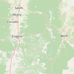
Map view of Willamette National Forest

Use this park location map to pinpoint Willamette National Forest in United States of America, understand its exact geographic position, and read its mapped placement within the surrounding landscape more clearly.

Pigeon | © OpenStreetMap contributors

Location context for Willamette National Forest

Oregon
Natural feature types

Navigate the Full Atlas of Natural Features in Willamette National Forest

Examine the intricate geography and mapped landforms of the Willamette National Forest region. This MoriAtlas collection provides a focused look at the peaks, rivers, and wilderness terrains that characterize this vital Pacific Northwest landscape, aiding deeper spatial discovery and regional understanding.
Recorded earthquake history

Explore Historical Earthquake Records for Willamette National Forest

Review the established catalogue of seismic events recorded near Willamette National Forest. MoriAtlas provides a consistent view of historical epicentre data and proximity metrics for this protected landscape to assist with deeper geographic understanding of the region.

Willamette National Forest Earthquake History

Catalogued events

19 events

Strongest magnitude

Magnitude 5.6

Most recent event

Oct 7, 2022

This history includes earthquakes recorded inside the park or within 50 km of its borders

Visualizing old growth forests, volcanic peaks, and river canyons in Oregon

Willamette National Forest Photos and Protected Landscapes

Visual records capture the towering old growth Douglas fir stands, glacial valleys, and rugged volcanic summits defining the western slopes of the Cascade Range. Examining photographic evidence reveals the complex topography, dense temperate rainforest habitats, and wild river corridors characteristic of the protected federal reserve.

A dirt trail winds through a dense old-growth forest with tall, mature evergreen trees and dappled sunlight.

A wide view of a river with a rocky bed flowing through a forested valley with mountains in the background.

Park atlas

Compare adjacent Cascade Range wilderness areas and regional protected terrain.

Other Parks Near Willamette National Forest and Surrounding Protected Landscapes

Browsing other parks near Willamette National Forest reveals connected ecological zones and volcanic topography across the Pacific Northwest. Regional comparison helps trace how temperate coniferous forests and alpine peaks extend throughout the broader mountain range.
Watercolor painting of a rolling mountain landscape with coniferous trees in the foreground and a hazy range of hills in the background.
Wildlife reserveOregon
Mapped location lies within the park boundary#1 closest

North

Menagerie Wilderness Wildlife Reserve: Oregon Cascade Range Geography and Rock Pinnacles

Protected Cascade mountain terrain and unique crag clusters

Situated in the central Cascade Range of Oregon, Menagerie Wilderness provides a compact, highly defined landscape of rising rock pinnacles and lush coniferous forest. This resource traces the unique topography and protected boundaries of this specialized wilderness area, offering insight into the geological features and forest ecosystems that distinguish it from surrounding mountainous terrain.

Area
20.37 km²
Established
1984
IUCN
Ib
Relief
Mountain
Wildlife reserveOregon
Park boundaries overlap#2 closest

North

Middle Santiam Wilderness: Geographic Atlas and Protected Landscape Overview of the Oregon Cascades

Old-growth forest basins and volcanic landmarks in the Willamette National Forest.

Middle Santiam Wilderness represents a distinct segment of the central Oregon Cascades. The area is defined by its substantial old-growth coniferous forests, including 450-year-old Douglas-fir and western hemlock stands, alongside the striking 4,965-foot volcanic plug known as Chimney Peak. This map-focused record traces the river-cut valleys and high-ridge topography that shape this protected habitat.

Area
34.57 km²
Established
1984
IUCN
Ib
Relief
Mountain
A watercolor painting showing a snowy mountain peak in the background rising above rolling green hills and pine forests in the foreground.
Protected landscapeOregon
Park boundaries overlap#3 closest

North

Mount Hood National Forest: Atlas of Protected Landscapes and Volcanic Geography

Exploring the Cascade Range terrain and wilderness boundaries in Oregon.

Mount Hood National Forest encompasses a vast, rugged expanse of the Oregon Cascades, anchored by the iconic, glacier-clad Mount Hood. This protected landscape contains extensive old-growth forests, high-alpine lakes, and deep river canyons. Discover the geographic extent of these wilderness areas and mountain terrain within the MoriAtlas database of protected lands.

Area
4,318.17 km²
Established
1908
Visitors
4.4M annual
Relief
Mountain
A horizontal watercolor illustration showing a landscape with soft rolling mountains in the distance, a line of pine trees in the midground, and a grassy shoreline in the foreground.
Wildlife reserveOregon
Park boundaries overlap#4 closest

Northeast

Mount Washington Wilderness: Volcanic Geology and Forested Cascade Terrain

A mapped overview of Oregon protected volcanic landscapes.

Mount Washington Wilderness offers a stark and compelling geological study of Oregon's central Cascades. From the shield volcano's basaltic remnants to the fragmented cinder cones of Belknap Crater, the area provides a window into explosive and effusive volcanic activity. Our geographic data maps the transition of conifer forests and subalpine zones across its rocky, lake-dotted interior, highlighting the unique character of this quiet protected preserve.

Area
219.66 km²
Established
1964
IUCN
Ib
Relief
Mountain
A watercolor illustration of rolling green hills, a small body of water, and distant mountain peaks against a plain white background.
Wildlife reserveOregon
7.9 km away#5 closest

South

Mount Thielsen Wilderness: Protected Volcanic Terrain and Glacial Landscapes in Oregon

Southern Cascade Range mountain and forest geography

Mount Thielsen Wilderness offers a compact yet dramatic study of southern Cascade topography. Dominated by its signature lightning-struck volcanic peak, the area encompasses a complex network of glacial cirques, deep valleys, and high-altitude forest zones. This map-rich entry point provides a closer look at the protected boundaries and natural geological features that define this significant segment of Oregon wilderness.

Area
223 km²
Established
1984
IUCN
Ib
Relief
Mountain
Protected landscapeOregon
About 16 km away#6 closest

South

Umpqua National Forest: Mapping the Protected Landscapes and Volcanic Terrain of Southern Oregon

A regional geography of the southern Cascade Range

Umpqua National Forest protects a critical expanse of southern Oregon, rising from river-carved timbered valleys to the high volcanic peaks of the Cascade Range. This atlas record details the forest's significant volcanic geology, sprawling old-growth habitats, and the Wild and Scenic North Umpqua River system. Explore the intricate boundaries of its wilderness areas and its relationship to the surrounding regional terrain through detailed geographic mapping and landscape analysis.

Area
3,978.58 km²
Established
1907
Visitors
799K annual
Relief
Mountain
Wildlife reserveOregon
23 km away#7 closest

South

Rogue-Umpqua Divide Wilderness: Protected Ridge Landscape and Watershed Geography

High-country wilderness area in southwestern Oregon

Rogue-Umpqua Divide Wilderness preserves a dense, high-elevation ridge environment that separates the Rogue and Umpqua river drainages. Featuring a complex mix of volcanic and sedimentary rock outcrops within a continuous conifer canopy, the area offers a unique look at forest ecology in the Klamath Mountains. The geography provides extensive views across both watersheds and stands as a primary example of protected montane forest terrain within the Oregon landscape.

Area
134 km²
Established
1984
IUCN
Ib
Water
Minor water
An artistic watercolor illustration showing a line of green evergreen trees in the foreground with hazy, distant mountains in the background against a light, neutral sky.
Protected landscapeOregon
25 km away#8 closest

Southwest

Rogue River, Siskiyou National Forest: Mapped Geography and Protected Area Overview

Tracing volcanic peaks and river-carved mountain terrain in Oregon

Spanning nearly 7,300 square kilometers, the Rogue River, Siskiyou National Forest acts as a crucial ecological anchor in the Pacific Northwest. This overview details its unique mountain geography, the extensive wilderness tracts within its boundaries, and the river systems that define its mountainous character.

Area
6,973.46 km²
Established
2004
Visitors
915K annual
Relief
Mountain

Common questions about visiting, size, designation, and location context for Willamette National Forest

Willamette National Forest FAQs for park facts, access, geography, and protected area context

Find quick answers about Willamette National Forest, including protected-area facts, park geography, trail and visitor context, and how the park fits into its surrounding country and regional landscape.
MoriAtlas Explorer

Continue Your Protected Areas Search Across the Global Atlas

Deepen your exploration by continuing the structured search for national parks and protected areas worldwide. Utilize the comprehensive filtering capabilities to compare different conservation landscapes and refine your understanding of global park geography. Discover more about the distribution and characteristics of protected natural areas.

Global natural geography