Mountain saddles
Knutson Saddle
1,337 m

A comprehensive analysis of forest landscape features, elevation spans, and area metrics
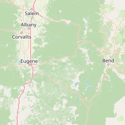
This geographic profile covers the extensive Willamette National Forest in Oregon, spanning over 6790 square kilometers of mountainous terrain. The documented environment includes diverse forest cover, major riverine systems, and significant volcanic elevations reaching 3200 meters above sea level.
Related tags
A Cascade Range national forest protecting old-growth forests, wild rivers, and high Cascades peaks in western Oregon.
Willamette National Forest is a large protected national forest running along the western slopes of the central Cascade Range in Oregon. Stretching for more than 100 miles, it encompasses old-growth Douglas-fir forest, snow-capped Cascade peaks, designated wilderness areas, Wild and Scenic rivers, and hundreds of lakes and streams. The forest is defined by the headwaters of the Willamette River and the rivers that drain the western Cascades. Its landscape includes everything from low-elevation forests to volcanic peaks above 10,000 feet, with a maritime climate that delivers heavy precipitation each year. This combination supports some of the tallest and oldest trees in North America. Willamette National Forest is notable not only for its scenery and biodiversity, but also for its central role in the late twentieth-century debate over old-growth logging, spotted owl habitat, and the future of federal forest policy in the Pacific Northwest.
National park geography across the United States and Oregon
Interactive boundary geometry and derived area measurements
Mountain relief spans from 460 meters up to 3200 meters across protected terrain.
Mountain saddles
1,337 m
Mountain saddles
1,291.1 m
Peaks
1,615.7 m
Peaks
1,600 m
Peaks
1,615 m
Peaks
1,782.8 m
Temperate coniferous forests, mountain relief, and major water features
Mountains · Valleys · Forest · Lakes · Rivers · Volcano
Temperate coniferous forest · Montane forest · Riverine habitat · Lacustrine habitat
Compare adjacent Cascade Range wilderness areas and regional protected terrain.

North

Protected Cascade mountain terrain and unique crag clusters
Situated in the central Cascade Range of Oregon, Menagerie Wilderness provides a compact, highly defined landscape of rising rock pinnacles and lush coniferous forest. This resource traces the unique topography and protected boundaries of this specialized wilderness area, offering insight into the geological features and forest ecosystems that distinguish it from surrounding mountainous terrain.
North
Old-growth forest basins and volcanic landmarks in the Willamette National Forest.
Middle Santiam Wilderness represents a distinct segment of the central Oregon Cascades. The area is defined by its substantial old-growth coniferous forests, including 450-year-old Douglas-fir and western hemlock stands, alongside the striking 4,965-foot volcanic plug known as Chimney Peak. This map-focused record traces the river-cut valleys and high-ridge topography that shape this protected habitat.

North
Exploring the Cascade Range terrain and wilderness boundaries in Oregon.
Mount Hood National Forest encompasses a vast, rugged expanse of the Oregon Cascades, anchored by the iconic, glacier-clad Mount Hood. This protected landscape contains extensive old-growth forests, high-alpine lakes, and deep river canyons. Discover the geographic extent of these wilderness areas and mountain terrain within the MoriAtlas database of protected lands.
Northeast
A mapped overview of Oregon protected volcanic landscapes.
Mount Washington Wilderness offers a stark and compelling geological study of Oregon's central Cascades. From the shield volcano's basaltic remnants to the fragmented cinder cones of Belknap Crater, the area provides a window into explosive and effusive volcanic activity. Our geographic data maps the transition of conifer forests and subalpine zones across its rocky, lake-dotted interior, highlighting the unique character of this quiet protected preserve.

South
Southern Cascade Range mountain and forest geography
Mount Thielsen Wilderness offers a compact yet dramatic study of southern Cascade topography. Dominated by its signature lightning-struck volcanic peak, the area encompasses a complex network of glacial cirques, deep valleys, and high-altitude forest zones. This map-rich entry point provides a closer look at the protected boundaries and natural geological features that define this significant segment of Oregon wilderness.
South
A regional geography of the southern Cascade Range
Umpqua National Forest protects a critical expanse of southern Oregon, rising from river-carved timbered valleys to the high volcanic peaks of the Cascade Range. This atlas record details the forest's significant volcanic geology, sprawling old-growth habitats, and the Wild and Scenic North Umpqua River system. Explore the intricate boundaries of its wilderness areas and its relationship to the surrounding regional terrain through detailed geographic mapping and landscape analysis.
South
High-country wilderness area in southwestern Oregon
Rogue-Umpqua Divide Wilderness preserves a dense, high-elevation ridge environment that separates the Rogue and Umpqua river drainages. Featuring a complex mix of volcanic and sedimentary rock outcrops within a continuous conifer canopy, the area offers a unique look at forest ecology in the Klamath Mountains. The geography provides extensive views across both watersheds and stands as a primary example of protected montane forest terrain within the Oregon landscape.

Southwest
Tracing volcanic peaks and river-carved mountain terrain in Oregon
Spanning nearly 7,300 square kilometers, the Rogue River, Siskiyou National Forest acts as a crucial ecological anchor in the Pacific Northwest. This overview details its unique mountain geography, the extensive wilderness tracts within its boundaries, and the river systems that define its mountainous character.
Continue your exploration of Willamette National Forest by delving into its unique volcanic terrain and protected wilderness systems. MoriAtlas provides a structured look at the mountain peaks, river valleys, and forest ecosystems that define this significant Oregon landscape.