Mori Atlas logo
National parkMount Lewis National Park

Trace the mapped boundaries and natural terrain of this Queensland national park.

Mount Lewis National Park: Protected Landscape Identity and Queensland Geographic Context

Mount Lewis National Park represents a distinct protected landscape within the state of Queensland, Australia. As a designated national park, its boundaries are mapped to preserve its natural geographic features and regional ecological context. Users can explore the park's unique terrain and understand its significance within the broader atlas of Queensland's diverse natural areas, contributing to a structured discovery of Australia's protected lands.

National ParkWet TropicsBiodiversity HotspotMountain ForestFar North QueenslandEndemic Species

Mount Lewis National Park

National park

Park overview

Structured park overview, official facts, and landscape profile for Mount Lewis National Park

Mount Lewis National Park park facts, protected area profile, and essential visitor context
Review the core facts for Mount Lewis National Park, including designation, size, terrain, visitor scale, habitats, and operating context in one park-focused overview.

About Mount Lewis National Park

Mount Lewis National Park preserves a substantial tract of mountainous terrain within Far North Queensland's internationally recognized Wet Tropics region. The park's establishment in 2009 represented a significant expansion of protected area coverage in this biodiversity-rich corridor, combining former forest reserves to create a more coherent conservation landscape. Its location adjacent to both Daintree National Park and Mount Spurgeon National Park creates a connected network of protected lands that collectively safeguard critical habitats and wildlife corridors.

The Mount Carbine Tableland that underlies the park provides a distinctive physical setting, with elevation changes creating diverse microclimates and habitat conditions throughout the protected area. Forest dominates the landscape, with vegetation communities varying according to aspect, elevation, and soil conditions. Wetlands scattered throughout the park add further ecological diversity, with these waterlogged areas supporting specialized plant and animal communities distinct from the surrounding forest. The park's position across multiple river catchments means its protection contributes to water quality and ecosystem health downstream in the broader landscape.

Quick facts and research context for Mount Lewis National Park

Mount Lewis National Park covers 278.6 square kilometers in Far North Queensland, Australia, established in 2009 through the amalgamation of two former forest reserves. The park sits on the Mount Carbine Tableland at coordinates 16°30′35″S 145°13′22″E, approximately 150 kilometers north of Cairns and accessible via Mount Lewis Road from Julatten. It is classified as IUCN Category II (national park) and managed by the Queensland Parks and Wildlife Service. The park forms part of the globally significant Wet Tropics of Queensland bioregion and contains important catchment areas for the Mitchell, Mossman, and Daintree Rivers.

Park context

Deeper park guide and search-rich context for Mount Lewis National Park

Mount Lewis National Park history, landscape, wildlife, and travel context
Explore Mount Lewis National Park through its history, landscape character, ecosystems, wildlife, conservation priorities, cultural context, and seasonal travel timing in a structured park guide built for atlas discovery and search intent.

Why Mount Lewis National Park stands out

Mount Lewis National Park is renowned as a biodiversity hotspot within the Wet Tropics of Queensland, protecting an exceptional concentration of rare and threatened species. The park is particularly famous for endemic species including the Mount Lewis spiny crayfish (Euastacus fleckeri), one of several crayfish species found nowhere else on Earth, and the giant blue earthworm. The mountain forests support outstanding birdlife, with golden bowerbirds and blue-faced parrotfinch being especially notable highlights for visitors exploring the clearings along Mount Lewis Road. The discovery of a small population of endangered northern bettongs in 2017 further cemented the park's significance as a refuge for vulnerable fauna.

River flowing through forested area with trees and vegetation in Mount Lewis National Park
Forest landscape within Mount Lewis National Park

Mount Lewis National Park history and protected-area timeline

Mount Lewis National Park was formally established in 2009 when the Queensland government combined Mount Lewis Forest Reserve and Riflemead Forest Reserve into a single national park entity. This consolidation reflected a growing recognition of the ecological significance of the Mount Carbine Tableland region and the need for coordinated protection across the landscape. The conversion of these former forest reserves to national park status elevated the level of environmental protection and brought the area under the management framework of the Queensland Parks and Wildlife Service.

Prior to national park designation, the area had been managed as state forest, with logging and other extractive uses permitted. The transition to national park status acknowledged the outstanding biodiversity values of the region and its importance within the Wet Tropics bioregion. This change in designation also aligned the area with the broader network of protected lands in Far North Queensland, including the adjacent Daintree National Park, creating a more cohesive conservation framework for the region.

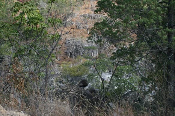
Mount Lewis National Park landscape and geographic character

The physical landscape of Mount Lewis National Park is defined by its position on the Mount Carbine Tableland, a elevated plateau region in Far North Queensland characterized by mountainous terrain and complex topography. The park's terrain features steep ridges, valley floors, and slopes that create substantial elevation variation across its 278.6 square kilometer extent. This varied topography influences drainage patterns, soil conditions, and vegetation distribution throughout the protected area.

Forest covers the majority of the park, with the dense vegetation reflecting the high rainfall and humid conditions typical of the Wet Tropics region. Along the ridges and upper slopes, forest composition reflects the drier conditions compared to the moister valley bottoms. Wetlands occupy approximately half of one percent of the park, representing important hydrological features that break up the forest matrix. The landscape lacks the dramatic coastal scenery found in some nearby protected areas, but the mountain forest environment offers a different kind of ecological beauty characterized by lush vegetation, complex forest structure, and the sounds of endemic wildlife.

Mount Lewis National Park ecosystems, habitats, and plant life

Mount Lewis National Park lies within two significant bioregions: the Wet Tropics of Queensland and the Einasleigh Uplands. This dual bioregional affiliation reflects the transitional nature of the landscape, which supports species and ecological communities from both regions. The Wet Tropics bioregion is globally recognized for its extraordinary biodiversity and endemism, with the Mount Lewis area representing some of the best-preserved forest within this World Heritage-listed landscape.

The park's biodiversity credentials are substantial, with 43 rare or threatened species documented within its boundaries. This concentration of conservation-significant species reflects the variety of habitats present and the relatively intact nature of the forest ecosystems. The mountainous environment creates a complex mosaic of habitats, from moist valley floors to drier ridge communities, supporting different species assemblages throughout the park. The wetland areas, though limited in extent, provide important ecological functions and habitat for species adapted to waterlogged conditions.

Mount Lewis National Park wildlife and species highlights

The wildlife community of Mount Lewis National Park includes several species of exceptional conservation significance and notable endemism. The Mount Lewis spiny crayfish (Euastacus fleckeri) represents the park's most distinctive endemic species, a crayfish found nowhere else in the world. This freshwater crustacean inhabits the streams and waterways of the Mount Carbine Tableland, where it occupies specific habitat requirements that make it vulnerable to environmental change.

Birdlife is a particular highlight, with the mountain clearings along Mount Lewis Road offering excellent opportunities to observe a variety of species. Golden bowerbirds, known for their elaborate bower-building behaviors, inhabit the forest and are regularly observed by visitors. The blue-faced parrotfinch, a colorful finch species associated with forest edges and clearings, adds to the park's birdwatching appeal. The park also supports populations of the cinereus ringtail possum and masked white-tailed rat, both marsupials adapted to the forest environment. The presence of the red-bellied black snake indicates a functioning reptile community, while several rare frog species breed in the park's wetlands and streams. The 2017 discovery of a small population of endangered northern bettongs, a small marsupial previously thought to have very restricted distributions, added significantly to the park's conservation importance.

Mount Lewis National Park conservation status and protection priorities

Mount Lewis National Park plays a crucial role in the conservation network of Far North Queensland, protecting a significant portion of the Wet Tropics bioregion's biodiversity. The park's inclusion in the Wet Tropics of Queensland, a World Heritage-listed landscape, reflects its global significance for biodiversity conservation. The 43 rare or threatened species recorded within the park include representatives from multiple taxonomic groups, demonstrating the comprehensive conservation values of the area.

The protection of catchment areas for three major river systems Mitchell, Mossman, and Daintree Rivers extends the park's conservation importance beyond its boundaries. These water catchments support downstream ecosystems and communities, and the forest cover within the park helps maintain water quality and regulate flows. The park's connection to adjacent protected areas including Daintree National Park and Mount Spurgeon National Park creates a larger conservation landscape that supports wildlife movements and ecological processes that require extensive areas of intact habitat.

Top sights and standout views in Mount Lewis National Park

Mount Lewis National Park stands out for its exceptional biodiversity within the Wet Tropics, the endemic Mount Lewis spiny crayfish, and its role in protecting important catchment areas. The park offers outstanding birdwatching opportunities, particularly at the clearings along Mount Lewis Road where golden bowerbirds and blue-faced parrotfinch can be observed. The discovery of northern bettongs in 2017 highlighted the park's ongoing scientific significance and the potential for additional discoveries. While the park lacks visitor facilities like camping areas, the four-wheel drive access and scenic forest drives make it a destination for those seeking a more remote wilderness experience in Far North Queensland.

Park location guide

Geography guide, regional context, and park location map for Mount Lewis National Park

Mount Lewis National Park park geography, regions, and map view in Australia
Understand where Mount Lewis National Park sits in Australia through a broader geographic reading of the surrounding landscape, nearby location context, and its mapped position within the national park landscape.

How Mount Lewis National Park fits into Australia

Australia is a constitutional monarchy and federal parliamentary democracy comprising six states and ten territories. With a population of nearly 28 million, it is one of the world's most urbanised countries, with most people concentrated on the eastern seaboard. The country has a high Human Development Index and is known for its cultural diversity, ancient Aboriginal heritage, and unique wildlife.

Wider geography shaping Mount Lewis National Park in Australia

Australia occupies the entire Australian continent, the island of Tasmania, and numerous smaller islands. It is the world's flattest and driest inhabited continent, featuring vast deserts in the interior (the Outback), tropical rainforests along the eastern coast, and a coastline bordering the Indian and Pacific Oceans.

Map view of Mount Lewis National Park

Use this park location map to pinpoint Mount Lewis National Park in Australia, understand its exact geographic position, and read its mapped placement within the surrounding landscape more clearly.

Pigeon | © OpenStreetMap contributors

Location context for Mount Lewis National Park

Queensland

Visual Atlas of Mountain Forest Landscapes, Wet Tropics Habitats, and Mount Lewis National Park's Unique Terrain

Explore Mount Lewis National Park: Immerse in its Mountain Forest Landscapes and Protected Area Scenery
Browse a curated collection of Mount Lewis National Park images to visually understand its rugged mountain forest landscapes and diverse Wet Tropics habitats. These photographs offer a clear view of the park's unique terrain, showcasing its ecological character and the protected environment of the Mount Carbine Tableland.

River flowing through forested area with trees and vegetation in Mount Lewis National Park

Park atlas

Browse the Network of Protected Landscapes Across the Wet Tropics of Queensland, Australia

Explore Other National Parks and Protected Areas Near Mount Lewis National Park
Continue your park exploration from Mount Lewis National Park to discover other protected areas and national parks in Far North Queensland, including contiguous zones like Daintree and Mount Spurgeon National Parks. Compare diverse landscapes and conservation efforts within the ecologically rich Wet Tropics of Queensland bioregion, tracing connections across its unique mountain forests and river catchments.
National parkQueensland

Mowbray National Park: Queensland National Park with Focused Geographic Identity

Exploring protected land and regional park context.

Mowbray National Park serves as a crucial protected area, offering specific insights into Queensland's diverse natural landscapes. This page details the park's designation as a national park, providing focused exploration of its mapped boundaries and its geographic place within northeastern Australia. Understand the conservation landscape and the atlas value Mowbray National Park contributes to the region's protected areas network.

Area
1.47 km²
Established
1989
IUCN
II
Climate
Tropical
National parkQueensland

Daintree National Park National Park: Protected Landscape and Regional Geography in Queensland

Explore mapped boundaries and Queensland's natural terrain.

Delve into the protected landscape of Daintree National Park, a significant national park situated in Queensland, Australia. This page offers a detailed exploration of its geographic features and mapped boundaries, providing essential context for understanding its role within the region's natural terrain. Discover the atlas-level significance of this protected area and its unique contribution to the Queensland landscape.

Area
1,200 km²
Established
1988
IUCN
II
Visitors
753K annual
National parkQueensland

Hann Tableland National Park: Queensland's Upland Forest National Park

Explore mapped boundaries and unique protected landscape.

Hann Tableland National Park, located in Queensland, Australia, is a protected area safeguarding a unique upland forest landscape within the Einasleigh Uplands. This national park is particularly notable for its conservation efforts for threatened marsupial species, including the northern greater glider and northern quoll, alongside the buff-breasted button-quail. Its relatively remote character and undeveloped natural environment offer a wilderness experience distinct from more accessible parks. Discover the mapped geography and protected-area context of Hann Tableland National Park, a vital component of northern Queensland's conservation landscape.

Area
108.2 km²
Established
1989
IUCN
II
Relief
Highland
National parkQueensland

Kuranda National Park: Protected Landscape and Mapped Geography in Queensland

Discover the natural terrain and park boundaries.

Kuranda National Park represents a distinct protected landscape within the state of Queensland, Australia. This detail page offers an atlas-centric view, focusing on the park's geographic setting, its mapped boundaries, and its contribution to the understanding of natural terrain across the region. Explore the core protected-area identity of Kuranda National Park to enhance your geographic discovery.

Area
271 km²
IUCN
II
Relief
Mountain
Climate
Tropical
National parkQueensland

Barron Gorge National Park: Queensland Protected Area Atlas and Landscape Discovery

Mapped boundaries and regional geographic context.

Delve into Barron Gorge National Park, a protected landscape integral to Queensland's geographic tapestry. This dedicated atlas entry provides critical details for understanding the park's mapped boundaries and its role as a national park within the broader regional context. Explore its identity as a protected natural area, enhancing your comprehension of Australia's diverse geography.

Area
28 km²
Established
1940
IUCN
II
Relief
Mixed relief
Watercolor illustration of a landscape with green hills, a winding river, and soft pink and yellow tones
National parkQueensland

Davies Creek National Park: A National Park within Queensland's Geography

Explore its protected land and regional map context.

Davies Creek National Park is a protected entity within the extensive geographic framework of Queensland, Australia. As a National Park, it contributes to the mapped conservation landscape of the region, offering a specific point for atlas-based exploration of natural terrain and protected areas. Understanding Davies Creek National Park means grasping its unique place within Queensland's diverse natural environments and its significance as a mapped protected region.

Area
4.86 km²
Established
1971
IUCN
II
Relief
Upland
National parkQueensland

Michaelmas and Upolu Cays National Park: Protected Landscape and Seabird Colony Geography

Explore Queensland's vital coral cay and marine protected area.

Michaelmas and Upolu Cays National Park, a significant national park in Queensland, offers a distinct look into coral cay geomorphology and island ecosystems. The park is globally recognized for its importance as a seabird breeding site, particularly for tern species, making it a key location for understanding coastal ecology and marine protected area functions within the Great Barrier Reef. Its mapped landscape showcases the contrast between vegetated and un-vegetated cays, providing valuable context for regional geography and conservation studies.

Area
30 km²
Established
1975
IUCN
II
Relief
Lowland
National parkQueensland

Ngalba Bulal National Park: Mapped Protected Landscape in Queensland

Explore Queensland's Ngalba Bulal National Park geography.

Ngalba Bulal National Park is identified as a national park within Queensland, Australia, offering a specific focus for protected landscape and geographic discovery. This entry provides essential map context for its protected boundaries and its contribution to the regional natural terrain. Understand the park's mapped identity and its place within the broader atlas of Australian protected areas, ideal for focused geographic study.

Established
2011
IUCN
II
Relief
Mixed relief
Climate
Tropical

Common questions about visiting, size, designation, and location context for Mount Lewis National Park

Mount Lewis National Park FAQs for park facts, access, geography, and protected area context
Find quick answers about Mount Lewis National Park, including protected-area facts, park geography, trail and visitor context, and how the park fits into its surrounding country and regional landscape.
MoriAtlas Explorer

Continue Your Protected Areas Search Across the Global Atlas

Deepen your exploration by continuing the structured search for national parks and protected areas worldwide. Utilize the comprehensive filtering capabilities to compare different conservation landscapes and refine your understanding of global park geography. Discover more about the distribution and characteristics of protected natural areas.

Global natural geography