
Mori Atlas logo
Wildlife reserveMount Trumbull Wilderness

A remote wildlife reserve showcasing dramatic mesa formations and high desert ecological transitions

Mount Trumbull Wilderness: Mapping the Volcanic Terrain and Protected Landscapes of the Arizona Strip

Mount Trumbull Wilderness occupies a significant footprint within the Uinkaret Plateau of northern Arizona, characterized by the rugged basalt-capped mesa that gives the area its name. As a protected wildlife reserve managed by the Bureau of Land Management, this landscape illustrates the geological story of the Colorado Plateau, featuring volcanic cinder cones, ancient ponderosa pine stands, and complex transitions from low desert scrub to higher forest elevations. The area offers an immersive look at a volcanic environment shaped by millions of years of activity near the Grand Canyon.

wilderness areavolcanic landscapebasalt mesacinder coneArizona StripUinkaret Plateau
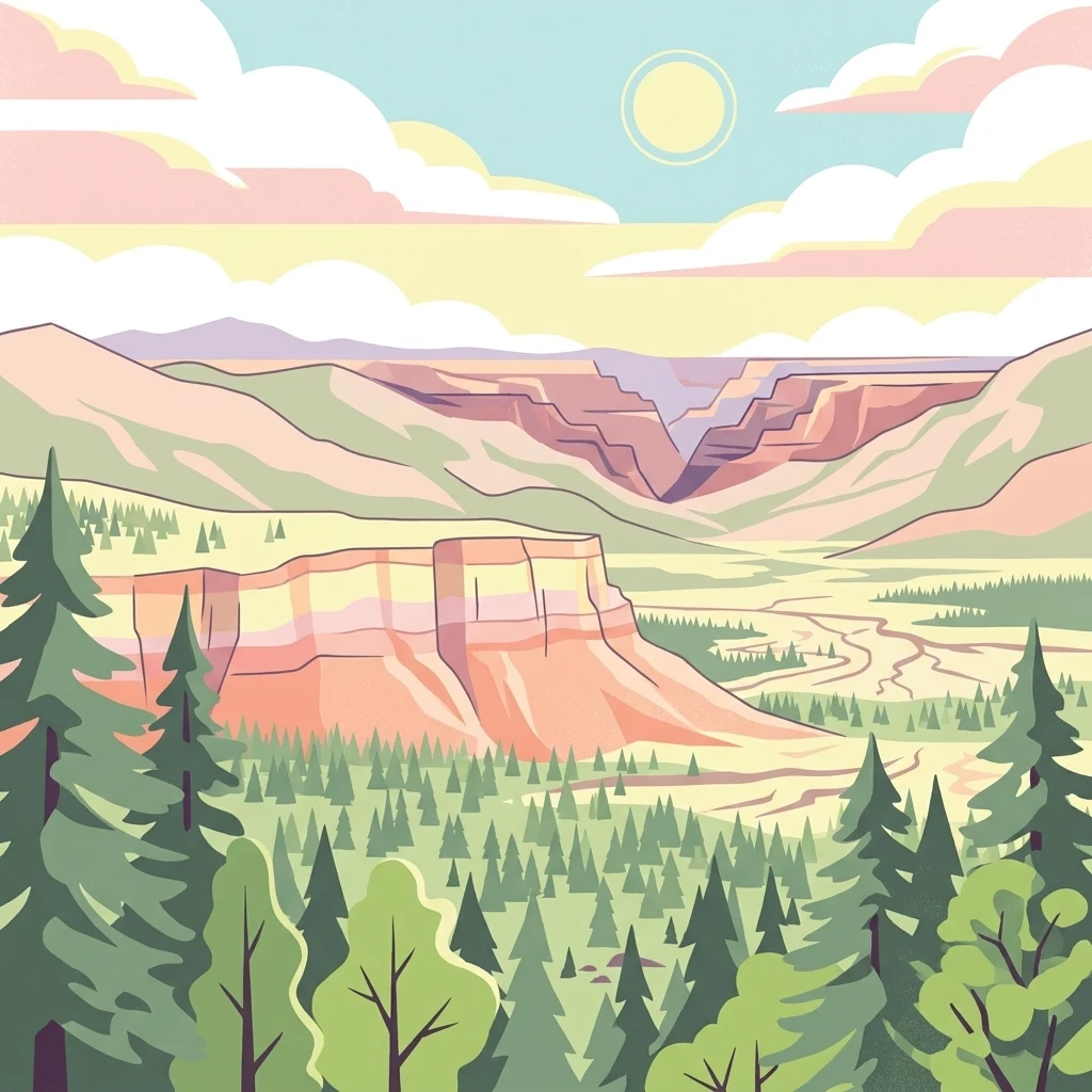
A digital illustration of a mountainous landscape with a deep canyon, pine forests, and a soft sunset sky.

Mount Trumbull Wilderness

Wildlife reserve

Park overview

Structured park overview, official facts, and landscape profile for Mount Trumbull Wilderness

Mount Trumbull Wilderness park facts, protected area profile, and essential visitor context

Review the core facts for Mount Trumbull Wilderness, including designation, size, terrain, visitor scale, habitats, and operating context in one park-focused overview.

About Mount Trumbull Wilderness

Mount Trumbull Wilderness protects one of the most striking volcanic landforms of the Arizona Strip, a remote and sparsely populated lobe of northwestern Arizona separated from the rest of the state by the deep trench of the Grand Canyon. The wilderness is small in extent but visually dominant, organized around the broad, flat-topped massif of Mount Trumbull, which rises from the Uinkaret Plateau to a summit exceeding eight thousand feet.

The area sits inside the Grand Canyon-Parashant National Monument, a vast landscape that links the Grand Canyon to the wider volcanic and canyon country of the Colorado Plateau. This positioning gives Mount Trumbull both a strong sense of isolation and a deep geological context: it is one of the older mesas in the Uinkaret volcanic field, and its basalt cap has helped shelter softer underlying rocks from erosion for millions of years. The mesa is also crowned by an undated cinder cone that erupted through the original basalt layer, leaving bright red volcanic debris visible along the trail to the top.

Ecologically, the wilderness shows a clear elevation gradient. Lower slopes support classic high desert vegetation, including Utah juniper, pinyon pine, sagebrush, and Mojave yucca, while higher elevations transition into ponderosa pine forest. The ponderosas are mostly relatively young, regrowing after intensive logging in the late nineteenth century, but surviving old growth individuals more than five hundred years old lend the forest a sense of ancient continuity. The combination of desert flats, forested mesa tops, and volcanic outcrops produces a varied habitat mosaic in a compact area.

Culturally, the wilderness carries a layered human story. Ancestral Puebloan peoples lived and traveled through this landscape, leaving archaeological traces that researchers continue to study each summer through field schools. In more recent centuries, Mormon settlers in nearby St. George used the Mount Trumbull area as a logging ground, harvesting timber for the construction of buildings in their communities. Together, these themes of geology, ecology, archaeology, and settlement history give the wilderness an unusually rich identity for its size.

Quick facts and research context for Mount Trumbull Wilderness

Mount Trumbull Wilderness is a federally designated wilderness area in Mohave County, in the far northwest of Arizona. It lies within the Grand Canyon-Parashant National Monument and is administered by the Bureau of Land Management as part of the National Wilderness Preservation System.

The wilderness was established in 1984 and protects a landscape built around a single prominent mesa, Mount Trumbull, whose flat summit rises well above the surrounding plateau. The area sits roughly sixty miles from the nearest towns of Fredonia, Arizona, and St. George, Utah, and is known for its combination of volcanic geology, pinyon-juniper and ponderosa vegetation, and wildlife typical of the Arizona Strip.

Protection and recognition

Terrestrial conservation scope and documented protected area framework

Mount Trumbull Wilderness Protection Status and Recognition Data

Mount Trumbull Wilderness maintains documented terrestrial protection status within official conservation frameworks. Certified records outline international recognition details and management scope for the protected landscape.

Protection details

Protection scope
Terrestrial
Transboundary protection
No
Park context

Deeper park guide and search-rich context for Mount Trumbull Wilderness

Mount Trumbull Wilderness history, landscape, wildlife, and travel context

Explore Mount Trumbull Wilderness through its history, landscape character, ecosystems, wildlife, conservation priorities, cultural context, and seasonal travel timing in a structured park guide built for atlas discovery and search intent.

Why Mount Trumbull Wilderness stands out

Mount Trumbull Wilderness is best known for its dramatic volcanic geology, anchored by a mesa capped with ancient basalt from the Uinkaret volcanic field. The summit of Mount Trumbull is reached by a short but steep trail and offers views over the surrounding plateau and toward the Grand Canyon to the south. The presence of very old ponderosa pines, some more than five centuries in age, also sets the wilderness apart, as do its scattered cinder cones and the lava flows that connect Mount Trumbull to the broader volcanic history of the Arizona Strip.
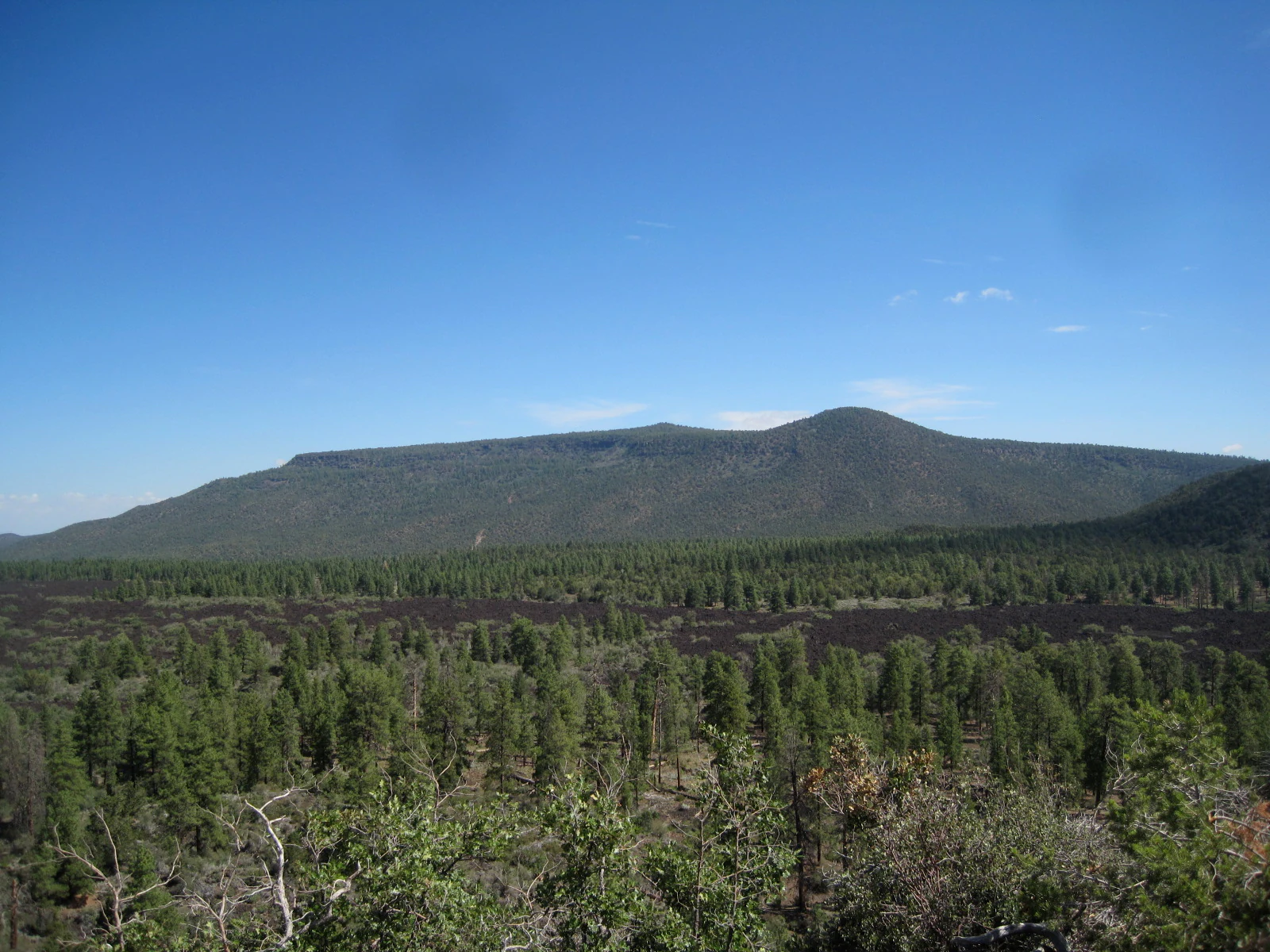
A wide, eye-level landscape shot of a long, dark volcanic mountain ridge covered in green pine forests, viewed from a slightly higher vantage point of a cinder cone under a clear blue sky.
A wide view of Mount Trumbull and the surrounding forested landscape as seen from a cinder cone.

Mount Trumbull Wilderness history and protected-area timeline

Mount Trumbull Wilderness was formally designated in 1984 as part of the National Wilderness Preservation System, administered by the Bureau of Land Management. Its establishment recognized both the volcanic and ecological values of the Mount Trumbull massif and its setting within the Arizona Strip, far from the more heavily visited corridors of northern Arizona.

Long before designation, the area had a working history tied to its forests. In the late nineteenth century, members of the Church of Jesus Christ of Latter-day Saints based in St. George, Utah, harvested timber from the slopes around Mount Trumbull to supply lumber for buildings in their growing community. This logging removed most of the mature ponderosa pines, and most of the ponderosas seen today have grown back since that period, though a small number of ancient, old growth specimens have survived.

The broader landscape also has a deep prehistoric record. Ancestral Puebloan peoples inhabited the area, and archaeological fieldwork is conducted each summer in and around the wilderness. In modern times, the region's archaeological, ecological, and geological values have been recognized through its inclusion in the Grand Canyon-Parashant National Monument, which surrounds and contains the Mount Trumbull Wilderness.

Mount Trumbull Wilderness landscape and geographic character

Mount Trumbull Wilderness is defined by the bold mesa of Mount Trumbull itself, which rises abruptly from the rolling surface of the Uinkaret Plateau. The mountain is a classic flat-topped mesa capped by a thick layer of dark grey basalt from a volcanic eruption roughly 3.6 million years ago, one of the earliest known events in the Uinkaret volcanic field. The basalt cap has shielded the colorful Moenkopi Formation underneath, preserving rocks that would otherwise have eroded away long ago.

The volcanic character of the area is central to its scenery. The Uinkaret volcanic field has produced at least 213 known eruptions over time, including seventeen separate lava flows that reached and temporarily dammed the Colorado River within the Grand Canyon. The most recent eruption in the area, at Little Springs, occurred only about 960 years ago, and its lava flow can still be traced along Bureau of Land Management road 1044 just south of Mount Trumbull. Scattered cinder cones, including one undated cone that sits on top of the mesa and ejected bright red cinders and lava bombs, punctuate the landscape and give it an unusually raw, volcanic texture for the Colorado Plateau.

The mesa's slopes show a stepped profile of rocky ledges, ledges of softer sedimentary rock, and benches of loose volcanic debris. A roughly two-and-a-half-mile trail climbs from Mohave County Road 5 to the summit, using switchbacks through red cinder deposits and old basalt. From the top, the plateau drops away in all directions, with views toward the Grand Canyon to the south and a wide sweep of high desert country extending in every other direction.
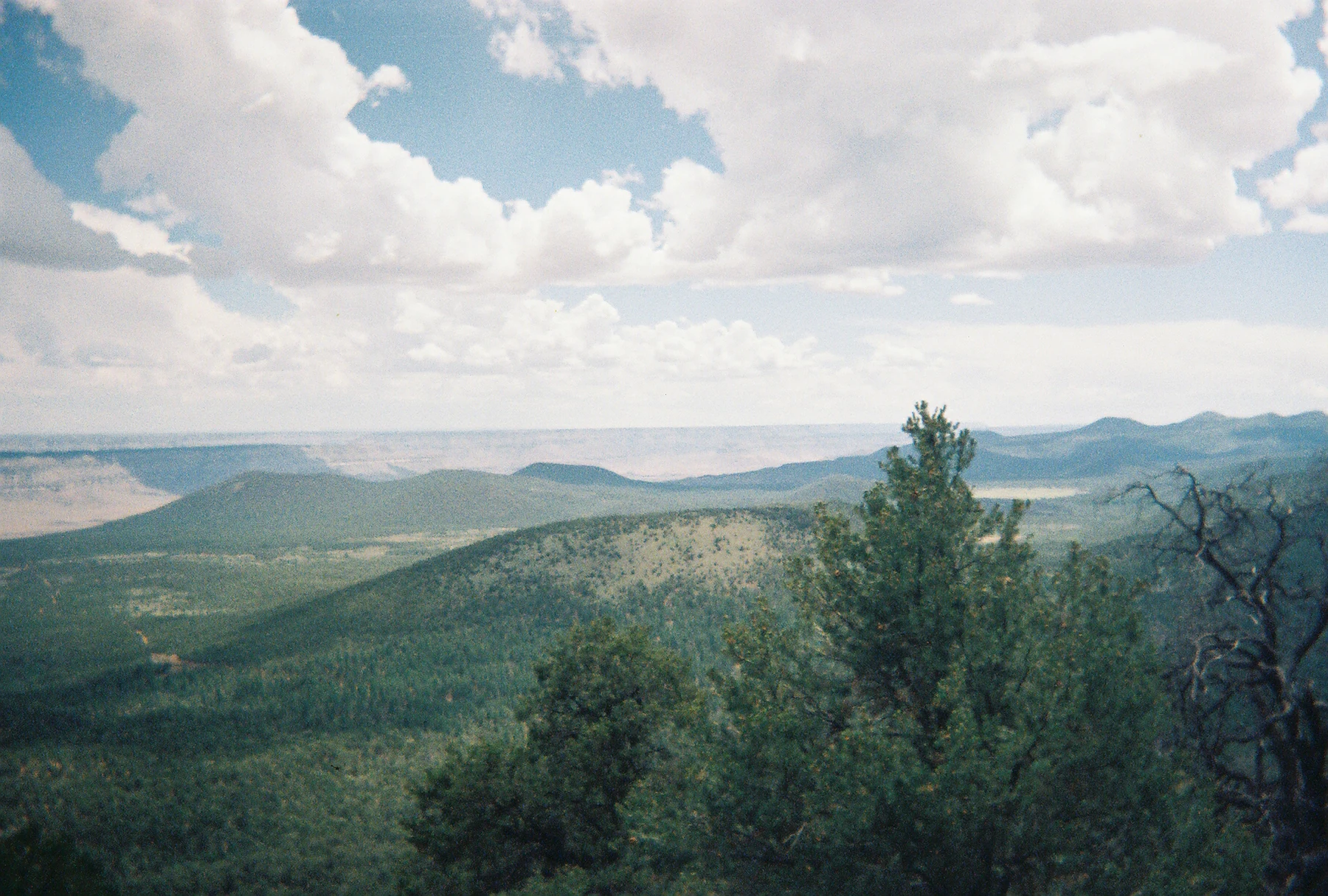
A high angle panoramic view of a dense pine forest spanning rolling hills and ridges under a partly cloudy sky, with a hints of a distant canyon in the far background.
A wide view looking over the forest landscape toward distant ridges within the Mount Trumbull Wilderness.

Mount Trumbull Wilderness ecosystems, habitats, and plant life

The vegetation of Mount Trumbull Wilderness reflects a clear ecological layering tied to elevation. At lower elevations, the slopes are dominated by Utah juniper and pinyon pine, classic trees of the high desert, growing alongside Mojave yucca and big sagebrush. These plants form open, sunlit woodlands with bare ground and rocky soils visible between them.

As elevation increases, the woodland gradually gives way to ponderosa pine forest. Because the area was logged heavily in the late nineteenth century, most of the ponderosas today are relatively young and small in stature. However, scattered old growth ponderosas, some more than five hundred years old, are still standing in the wilderness and lend the upper forest an unusual sense of age and stability. A variety of native grasses grow intermittently across the wilderness, filling open spaces between trees and reinforcing the mosaic feel of the landscape.

As a whole, the wilderness spans the transition between Great Basin and Colorado Plateau vegetation patterns, mixing true high desert species in its lower zones with mountaintop conifers at its highest. This gradient, combined with the volcanic substrate, defines the ecological identity of the area.

Mount Trumbull Wilderness wildlife and species highlights

Mount Trumbull Wilderness supports a typical Arizona Strip mix of high desert and forested wildlife. Mule deer are among the most frequently observed large mammals, regularly seen during morning and late afternoon hours in the open woodland. Pronghorn are more rarely encountered but are part of the fauna, and mountain lions are also present as elusive predators roaming the plateau.

Squirrels are a notable presence throughout the wilderness. The area is home to the unusual Kaibab squirrel, a distinct subspecies whose range is centered on the Kaibab Plateau north of the Grand Canyon and which was intentionally introduced to the Mount Trumbull area from the south rim of the Grand Canyon in the 1970s. The squirrel population as a whole, including more common species, contributes to the dynamic of seed dispersal and forest regeneration.

Reptiles and birds round out the wildlife profile. Horned lizards and other lizard species are found in the dry, open habitats of the lower slopes. The forested reaches and rim of the mesa host a variety of birds, including red crossbills, Steller's jays, and common ravens, among many other species typical of pinyon-juniper and ponderosa habitats.

Mount Trumbull Wilderness conservation status and protection priorities

Mount Trumbull Wilderness is one of a network of small wilderness areas on the Arizona Strip that together protect the ecological and geological character of a remote and lightly developed part of the Colorado Plateau. Its designation in 1984 under the National Wilderness Preservation System gave lasting federal protection to the mesa and its surrounding terrain, preserving the area from further logging, road-building, and development.

The wilderness plays an important role within the larger Grand Canyon-Parashant National Monument, which encompasses Mount Trumbull and provides a broader framework of conservation management. By protecting the transition from low desert vegetation to mountaintop ponderosa forest in such a compact area, the wilderness helps maintain habitat continuity across a region where development pressures are otherwise intense across the wider American West.

The volcanic geology of the area is itself a conservation value. The basalt cap of Mount Trumbull preserves a record of early activity in the Uinkaret volcanic field, while the surrounding cinder cones and lava flows, including the relatively young Little Springs flow, provide insight into the recent volcanic history of the Grand Canyon region. Combined with the presence of old growth ponderosa pines older than five centuries, these features make the wilderness a significant reference site for understanding long term landscape change on the Colorado Plateau.

Mount Trumbull Wilderness cultural meaning and human context

The cultural landscape of Mount Trumbull Wilderness stretches back thousands of years. Ancestral Puebloan peoples inhabited the Arizona Strip, including the areas around Mount Trumbull, and the wilderness contains both prehistoric and historic archaeological sites that researchers continue to investigate. An archaeological field school operates in and around the area each summer, providing ongoing insight into how these earlier populations used the plateau.

In the nineteenth century, the area became an important resource for Mormon settlers in St. George, Utah. Members of the Church of Jesus Christ of Latter-day Saints traveled into the Mount Trumbull country to harvest timber, using the harvested wood to build many of the early structures of their community. This logging episode shaped the modern forest, leaving most of the existing ponderosas as regrowth, and remains a defining chapter in the recent human history of the wilderness.

Top sights and standout views in Mount Trumbull Wilderness

Mount Trumbull Wilderness offers a compact but unusually concentrated set of highlights. The mesa itself, with its dark basalt cap and bright red cinder cone, is the centerpiece, and the short but steep trail to the summit rewards visitors with broad views of the Uinkaret Plateau and the nearby edge of the Grand Canyon. Ancient ponderosa pines, the ongoing presence of the Kaibab squirrel, and the chance to see mule deer, pronghorn, and mountain lions in a remote setting add ecological depth. Layered on top of these natural features are the cultural traces of Ancestral Puebloan peoples and nineteenth-century Mormon logging, giving the wilderness a strong sense of layered human story.

Best time to visit Mount Trumbull Wilderness

Because Mount Trumbull Wilderness lies in the high desert of the Arizona Strip, the character of a visit shifts with the seasons. Spring and fall generally offer the most comfortable conditions for hiking, with mild daytime temperatures and the chance to see wildflower blooms and autumn color in the vegetation at lower elevations. Summer can be hot and exposed, especially on the lower trails, though the higher elevations around the summit of Mount Trumbull remain cooler and are a good refuge from the heat of the surrounding plateau.

Winter brings cold temperatures and possible snow on the mesa, which can make the summit trail more challenging but also produces a quieter, more contemplative atmosphere. Wildlife viewing, particularly for mule deer and squirrels, is often best in the cooler hours of early morning and late afternoon across all seasons.
Monthly climate preview

Long term temperature and precipitation records across twelve recorded intervals

Mount Trumbull Wilderness Climate Normals and Annual Weather Patterns

Representative coordinate measurements for Mount Trumbull Wilderness capture long term monthly temperature extremes and daily precipitation averages spanning from 1991 to 2020. Examining the complete twelve month profile provides detailed climatological context for evaluating regional atmospheric conditions.
Annual mean13 °C
2 °C26 °C
Jan
Feb
Mar
Apr11°
May17°
Jun23°
Jul26°
Aug25°
Sep21°
Oct13°
Nov
Dec
Warmest month
July

26.1 °C

Coolest month
December

1.6 °C

Wettest month
February

1.3 mm/day

Driest month
June

0.2 mm/day

Park location guide

Geography guide, regional context, and park location map for Mount Trumbull Wilderness

Mount Trumbull Wilderness park geography, regions, and map view in United States of America

Understand where Mount Trumbull Wilderness sits in United States of America through a broader geographic reading of the surrounding landscape, nearby location context, and its mapped position within the national park landscape.

How Mount Trumbull Wilderness fits into United States of America

The United States of America is a federal presidential republic and one of the world's largest countries by area and population. It consists of 50 states across a vast territory spanning multiple time zones, with its capital in Washington, D.C. and largest city in New York City. The nation has a diverse economy, influential political system, and significant cultural and military presence globally.

Wider geography shaping Mount Trumbull Wilderness in United States of America

The United States occupies a vast territory in North America, bordered by Canada to the north and Mexico to the south. The 48 contiguous states stretch from the Atlantic to the Pacific Ocean, while Alaska occupies the northwestern region and Hawaii is an archipelago in the Pacific. The country encompasses diverse terrain including the Rocky Mountains, Appalachian Mountains, Great Plains, and extensive river systems.

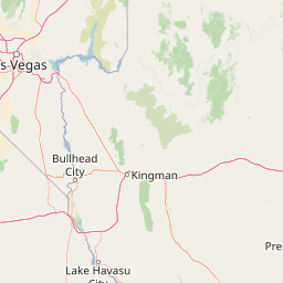
Map view of Mount Trumbull Wilderness

Use this park location map to pinpoint Mount Trumbull Wilderness in United States of America, understand its exact geographic position, and read its mapped placement within the surrounding landscape more clearly.

Pigeon | © OpenStreetMap contributors

Location context for Mount Trumbull Wilderness

Arizona
Recorded earthquake history

Review the Recorded Earthquake History for Mount Trumbull Wilderness

Examine the catalogued seismic events associated by distance with Mount Trumbull Wilderness. This resource provides a clear view into recorded historical ground motion across the Uinkaret Plateau, allowing for easier exploration of seismic patterns within the regional landscape.

Mount Trumbull Wilderness Earthquake History

Catalogued events

18 events

Strongest magnitude

Magnitude 4.4

Most recent event

Sep 19, 2022

This history includes earthquakes recorded inside the park or within 50 km of its borders

Explore high desert terrain, ancient basalt mesas, and remote volcanic scenery in northern Arizona

Mount Trumbull Wilderness Photos and Landscapes: Visualizing the Volcanic Plateau

Visual records reveal the dramatic basalt-capped mesas, ancient cinder cones, and rugged high desert terrain that define the Uinkaret Plateau. Photographic coverage captures ecological transitions from sparse juniper woodlands to centuries-old ponderosa pines across the remote protected landscape.

A wide, eye-level landscape shot of a long, dark volcanic mountain ridge covered in green pine forests, viewed from a slightly higher vantage point of a cinder cone under a clear blue sky.

A gnarled, leafless, dead tree occupies the foreground against a clear blue sky, overlooking a wooded hillside.

A high angle panoramic view of a dense pine forest spanning rolling hills and ridges under a partly cloudy sky, with a hints of a distant canyon in the far background.

Park atlas

Compare regional volcanic landscapes and neighboring plateau reserves

Parks Near Mount Trumbull Wilderness and Surrounding Protected Areas

Browse protected areas and rugged volcanic landscapes located near Mount Trumbull Wilderness. Comparing adjacent canyon country reserves reveals broader regional geology across the Arizona Strip.
National parkArizona
4.1 km away#1 closest

Southeast

Grand Canyon National Park: Arizona National Park Protected Landscape & Geography

Explore mapped boundaries and regional atlas context.

Grand Canyon National Park stands as a premier national park, showcasing a unique protected landscape within Arizona's diverse geography. This detailed entry focuses on the park's specific geographic identity, its mapped boundaries, and its significance within the regional atlas. Discover the contours of this protected area and its place in the natural terrain of the American Southwest.

Area
4,926.08 km²
Established
1919
IUCN
II
Visitors
4.9M annual
A minimalist watercolor painting depicting a pale desert landscape with soft green hills and light reddish rock formations against a white background.
Wildlife reserveArizona
36 km away#2 closest

East

Kanab Creek Wilderness: Protected Canyon Landscapes and Geography of Northern Arizona

Extensive tributary canyon systems and plateau terrain

Kanab Creek Wilderness represents a vast protected area in northern Arizona, defined by deep gorges and vertical cliffs etched into the Kanab and Kaibab Plateaus. This geographic atlas entry provides insights into the canyon network that feeds the Colorado River, highlighting the extreme elevation gradients and archaeological significance of this rugged wilderness.

Area
305 km²
Established
1984
IUCN
Ib
Relief
Upland
A horizontal watercolor illustration showing a calm lake in the foreground, surrounded by grassy banks, evergreen trees, and rolling mountains in the distance under a pale sky.
Protected landscapeArizona
38 km away#3 closest

East

Kaibab National Forest: Protected Plateau Landscapes and Forested Geography in Arizona

High-elevation forest terrain bordering the Grand Canyon

Spanning over 1.6 million acres in Arizona, Kaibab National Forest is characterized by its split geographic configuration, with distinct sections flanking the North and South rims of the Grand Canyon. The terrain ranges from the high-altitude Kaibab Plateau to volcanic uplands near Williams, encompassing four designated wilderness areas and varied forest ecosystems that provide a critical buffer for the surrounding canyon country.

Area
6,500 km²
Established
1909
Relief
Mountain
Climate
Temperate
A watercolor painting showing a soft-toned landscape with a winding river in the foreground, a forested middle ground, and rolling mountains in the distance.
Protected landscapeUnited States of America
64 km away#4 closest

West

Lake Mead National Recreation Area: Desert Reservoir and Protected Landscape Atlas

United States protected geography and reservoir terrain

Spanning the lower Colorado River, Lake Mead National Recreation Area represents a unique convergence of desert ecosystems and large-scale water management. Its geography includes extensive reservoir shorelines, deep canyon corridors, and volcanic basin terrain that provide a foundational look at the arid environments of the American Southwest. The area remains a significant study of how engineered water features alter and interact with complex desert landscapes.

Area
6,053.31 km²
Established
1936
IUCN
V
Visitors
6.4M annual
National parkUtah
80 km away#5 closest

North

Zion National Park National Park: Detailed Mapped Geography and Protected Landscape Identity

Explore the mapped terrain and regional context of this Utah national park.

Zion National Park represents a key protected area within Utah, ideal for detailed geographic exploration. This canonical page offers insights into the park's specific mapped boundaries, its inherent landscape character, and its regional geographic setting. It is designed for users seeking to understand the atlas-level significance of Zion National Park as a national park entity, focusing on its protected terrain and natural geography.

Area
593.26 km²
Established
1919
IUCN
II
Visitors
4.9M annual
Wildlife reserveClark County
About 93 km away#6 closest

West

Jumbo Springs Wilderness: Geographic Profile and Protected Landscape Atlas

A rugged desert preserve in Clark County, Nevada

Jumbo Springs Wilderness preserves a dense concentration of desert geology within a compact footprint. Users can analyze the protected boundaries, which feature Precambrian metamorphic formations and granitic domes that rise above arid drainages. This area functions as a critical desert refuge near the Lake Mead reservoir, providing a distinct look at the transition between rocky mountain slopes and water-influenced desert microhabitats.

Area
18.74 km²
Established
2002
IUCN
Ib
Relief
Upland
Wildlife reserveUtah
94 km away#7 closest

Northwest

Red Mountain Wilderness: Mapped Sandstone Massif and Protected Landscape in Utah

Ecological transitions between the Mojave Desert and Great Basin

Red Mountain Wilderness is a distinct protected landscape in southwestern Utah characterized by its dramatic Navajo sandstone block. Positioned near the Gunlock Fault and Snow Canyon, the area features rugged desert terrain where Mojave and Great Basin ecosystems converge. This wilderness preserves significant archaeological history and diverse plant communities within its sandstone canyons and flats, offering a window into the varied natural environment of the region.

Area
75.8 km²
Established
2009
IUCN
Ib
Relief
Upland
Wildlife reserveWashington County
About 113 km away#8 closest

North

LaVerkin Creek Wilderness: Mapping Protected Landscapes in Southwestern Utah

Wildlife reserve and watershed protection in Washington County

This protected area unit serves as a critical buffer for the upper LaVerkin Creek corridor. Its terrain spans the transition from high-elevation forested plateaus to deeply carved sedimentary canyons. By maintaining an unroaded status, the wilderness preserves essential riparian habitats and geological features that define the character of the surrounding southwestern Utah plateau region.

Area
1.8 km²
Established
2009
IUCN
Ib
Relief
Highland

Common questions about visiting, size, designation, and location context for Mount Trumbull Wilderness

Mount Trumbull Wilderness FAQs for park facts, access, geography, and protected area context

Find quick answers about Mount Trumbull Wilderness, including protected-area facts, park geography, trail and visitor context, and how the park fits into its surrounding country and regional landscape.
MoriAtlas Explorer

Continue Your Protected Areas Search Across the Global Atlas

Deepen your exploration by continuing the structured search for national parks and protected areas worldwide. Utilize the comprehensive filtering capabilities to compare different conservation landscapes and refine your understanding of global park geography. Discover more about the distribution and characteristics of protected natural areas.

Global natural geography