Mori Atlas logo
Marine protected areaMoutere Ihupuku / Campbell Island Marine Reserve

Examining the volcanic seafloor and subantarctic habitats of New Zealand's remote southern island territory.

Moutere Ihupuku / Campbell Island Marine Reserve: Mapped Marine Protected Area Geography

Moutere Ihupuku / Campbell Island Marine Reserve encompasses the rugged marine waters surrounding a deeply eroded shield volcano in the New Zealand Subantarctic Islands. This protected area reveals a complex underwater landscape of basalt pinnacles, sponge gardens, and boulder fields that mirror the dramatic cliffs and coastal terrain of the island above. Serving as a sanctuary for globally significant seabird colonies and marine wildlife, the reserve offers a unique look at the geological and biological character of the Southern Ocean.

subantarctic islandsmarine reserveseabird breedingalbatrossvolcanic islandshield volcano

Moutere Ihupuku / Campbell Island Marine Reserve

Marine protected area

Park overview

Structured park overview, official facts, and landscape profile for Moutere Ihupuku / Campbell Island Marine Reserve

Moutere Ihupuku / Campbell Island Marine Reserve park facts, protected area profile, and essential visitor context

Review the core facts for Moutere Ihupuku / Campbell Island Marine Reserve, including designation, size, terrain, visitor scale, habitats, and operating context in one park-focused overview.

About Moutere Ihupuku / Campbell Island Marine Reserve

Moutere Ihupuku / Campbell Island Marine Reserve protects the waters surrounding Campbell Island, New Zealand's southernmost landmass and one of the most remote islands in the country's subantarctic region. Sitting roughly 660 kilometres south of the South Island in the wild Southern Ocean, Campbell Island belongs to the New Zealand Subantarctic Islands, a chain of isolated, wind-swept landforms that hold exceptional scientific, ecological, and cultural value. The reserve was created in 2014 to formalize long-standing recognition of this region's outstanding natural character and to extend protection into the surrounding sea.

At the heart of the reserve is a volcanic island shaped by millions of years of erosion. The land rises in dramatic cliffs, drops to boulder beaches and occasional sandy shores, and folds into sheltered inlets and exposed rocky reef. Beneath the waves, that geological inheritance continues. Underwater surveys have revealed basalt pinnacles rising from the seafloor, expansive sponge beds, reefs draped in seaweed, scattered boulder fields, and unusually dense aggregations of very large spider crabs. The combination of volcanic heritage and cold Southern Ocean productivity creates an underwater environment that is unusually varied for such a remote setting.

Wildlife is central to the reserve's identity. The island area supports the world's largest population of southern royal albatross and provides globally significant breeding habitat for five additional albatross and mollyhawk species. On the coast and in the near-shore waters, rockhopper penguins, New Zealand sea lions, southern elephant seals, and New Zealand fur seals breed, feed, and rear young in conditions that have remained relatively undisturbed by direct human pressure. Marine mammals and seabirds frequently forage close to shore when feeding chicks, while wider-ranging species travel thousands of kilometres across the Pacific before returning to land.

The reserve is administered by the New Zealand Department of Conservation, with operational support from the Royal New Zealand Navy given the extreme remoteness and logistical complexity of the location. Access is tightly managed: visitors are permitted only through guided tours and must hold a permit, with rules in place to keep human impact to a minimum. The reserve's dual name, Moutere Ihupuku alongside Campbell Island, reflects recognition of the cultural connections Ngāi Tahu maintain with these southern islands, an association that has guided subsequent government reviews of the reserve's boundaries and management approach.

Quick facts and research context for Moutere Ihupuku / Campbell Island Marine Reserve

Moutere Ihupuku / Campbell Island Marine Reserve is a protected marine area in New Zealand's Subantarctic Islands, centred on Campbell Island, the country's southernmost island. The reserve was gazetted on 2 March 2014 alongside the Moutere Mahue / Antipodes Island Marine Reserve and the Moutere Hauriri / Bounty Islands Marine Reserve, marking a major step in subantarctic marine protection.

It covers roughly 39 percent of the territorial sea of the Campbell Island group, with bottom trawling, seining, and dredging also banned across the remaining 61 percent of surrounding waters. The reserve is administered by the Department of Conservation, visitors require permits and must join guided tours, and its management reflects consultation with Ngāi Tahu and Te Ohu Kaimoana.

Protection and recognition

Documented marine protection scope and official designation records

Moutere Ihupuku / Campbell Island Marine Reserve Protection Status

Marine protection status and management scope details define the conservation framework established for Moutere Ihupuku / Campbell Island Marine Reserve. Structured designation records outline the governing parameters and documented recognition associated with this protected marine area.

Protection details

Protection scope
Marine
Park context

Deeper park guide and search-rich context for Moutere Ihupuku / Campbell Island Marine Reserve

Moutere Ihupuku / Campbell Island Marine Reserve history, landscape, wildlife, and travel context

Explore Moutere Ihupuku / Campbell Island Marine Reserve through its history, landscape character, ecosystems, wildlife, conservation priorities, cultural context, and seasonal travel timing in a structured park guide built for atlas discovery and search intent.

Why Moutere Ihupuku / Campbell Island Marine Reserve stands out

The reserve is best known for hosting the world's largest population of southern royal albatross, together with globally significant breeding grounds for five other albatross and mollyhawk species. Campbell Island's colonies are among the most important seabird sites anywhere in the Southern Ocean. Equally distinctive is the underwater landscape encircled by the reserve. Submerged remnants of a shield volcano create a seafloor mosaic of basalt pinnacles, sponge gardens, seaweed-encrusted reefs, boulder fields, and dense populations of very large spider crabs, making the waters around Campbell Island a benchmark for subantarctic marine habitat diversity.
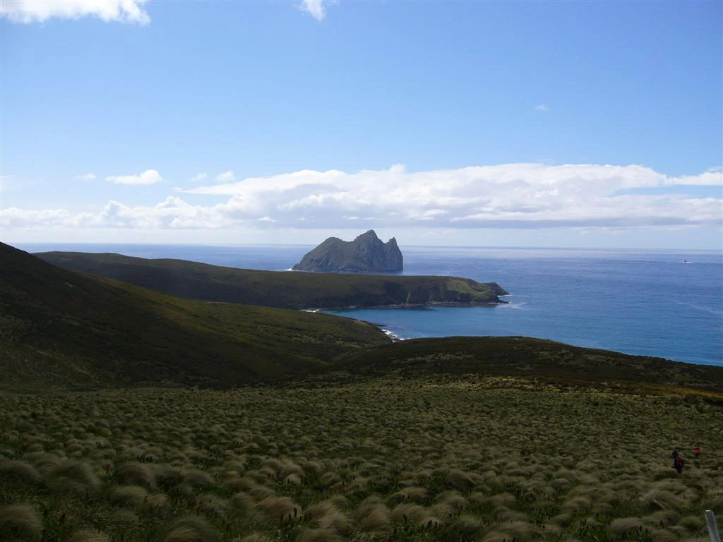
A wide coastal landscape view showing low, grassy hills leading down to the ocean, with the distinctive rocky peak of Dent Island rising from the sea in the distance under a blue sky.
A view looking across the coastal landscape towards Dent Island, as seen from Campbell Island.

Moutere Ihupuku / Campbell Island Marine Reserve history and protected-area timeline

Moutere Ihupuku / Campbell Island Marine Reserve was formally established on 2 March 2014, on the same day as two companion reserves in New Zealand's subantarctic region: the Moutere Mahue / Antipodes Island Marine Reserve and the Moutere Hauriri / Bounty Islands Marine Reserve. Together, these designations marked one of the most significant expansions of marine protection in New Zealand's subantarctic waters.

At the time of its creation, the reserve covered approximately 39 percent of the territorial sea around the Campbell Island group. Equally important was the broader regulatory framework introduced alongside it, which extended bans on bottom trawling, seining, and dredging to the remaining 61 percent of territorial seas that fell outside the reserve itself, providing comprehensive protection across the island group's waters.

In 2018, the government undertook a review of the marine reserve that included formal consultation with Ngāi Tahu and Te Ohu Kaimoana. Following this review, the decision was made not to extend the reserve boundaries to encompass the remaining 61 percent of the surrounding territorial seas, leaving the existing zoning and activity prohibitions in place.

Moutere Ihupuku / Campbell Island Marine Reserve landscape and geographic character

Campbell Island, the landmass at the centre of the reserve, sits more than 600 kilometres south of New Zealand's South Island and is the country's most southerly island. The terrain reflects its volcanic origins. The island consists of the deeply eroded remains of an ancient shield volcano, and its modern shape is dominated by large cliffs, boulder-strewn beaches, occasional sandy stretches, and a coastline that alternates between sheltered inlets and exposed rocky reef.

The marine reserve extends this dramatic physical character below sea level. The seafloor mirrors the island's volcanic geology with basalt pinnacles, broken reef structures, and boulder fields that rise and fall across the continental shelf. Soft sediment accumulates in deeper basins, while wave-exposed zones host encrusting marine life on hard substrates. The result is a varied and rugged subantarctic seascape shaped by the same forces that moulded the island itself.

Moutere Ihupuku / Campbell Island Marine Reserve ecosystems, habitats, and plant life

The ecosystems protected by the reserve blend subantarctic terrestrial habitats with cold-temperate marine environments. Above the surface, windswept slopes, tussock grasslands, and cliff faces support breeding seabirds and marine mammals, with the surrounding ocean providing the food resources that sustain them. The marine environment is shaped by cool Southern Ocean waters, strong currents, and high nutrient upwelling, conditions that drive rich productivity across multiple habitats.

The reserve's submerged habitats include extensive sponge beds dominated by filter-feeding communities, reefs encrusted with seaweed and other macroalgae, and boulder fields that shelter invertebrates and crustaceans. Soft sediment plains lie alongside harder volcanic substrates, producing a mosaic of habitat types in a relatively compact area. This diversity is unusual for a subantarctic setting and contributes directly to the ecological importance of the reserve.

Moutere Ihupuku / Campbell Island Marine Reserve wildlife and species highlights

Wildlife is the defining feature of Moutere Ihupuku / Campbell Island Marine Reserve. The reserve is internationally recognized for hosting the world's largest population of southern royal albatross, and Campbell Island is regarded as a globally significant breeding ground for five additional albatross and mollyhawk species. These long-lived seabirds rely on the island's predator-free conditions and rich surrounding ocean to raise their chicks.

Breeding populations of rockhopper penguins crowd coastal rocks and cliff bases, while New Zealand sea lions, southern elephant seals, and New Zealand fur seals haul out along beaches and rocky shores. Marine mammals and seabirds frequently forage close to shore when feeding young, though many species range across vast distances of the Pacific Ocean before returning to land.

Beneath the surface, biological richness is equally striking. The boulder fields and sponge gardens host abundant invertebrate life, and the reserve is noted for large numbers of very large spider crabs, a feature that distinguishes Campbell Island waters from many other subantarctic sites.

Moutere Ihupuku / Campbell Island Marine Reserve conservation status and protection priorities

Moutere Ihupuku / Campbell Island Marine Reserve represents a critical layer of protection for one of the most ecologically valuable subantarctic regions under New Zealand jurisdiction. By formally designating 39 percent of the territorial sea as a marine reserve, and by simultaneously banning bottom trawling, seining, and dredging across the remaining 61 percent, the 2014 framework created near-complete protection for the marine environment surrounding Campbell Island.

The reserve's conservation significance extends beyond its boundaries. As habitat for the world's largest southern royal albatross population and globally important breeding grounds for several other seabird species, it plays a disproportionate role in the survival of Southern Ocean seabird communities. The presence of multiple seal and penguin breeding colonies adds further weight to its importance for marine mammal and seabird conservation.

The consultation with Ngāi Tahu and Te Ohu Kaimoana during the 2018 review reflects an evolving approach to subantarctic conservation that integrates indigenous cultural values alongside ecological considerations, ensuring that protection efforts remain grounded in both natural and cultural heritage.

Moutere Ihupuku / Campbell Island Marine Reserve cultural meaning and human context

The dual name of the reserve reflects the cultural significance of Campbell Island to Ngāi Tahu, the principal Māori iwi with ancestral connections extending across New Zealand's southernmost regions. Recognition of Ngāi Tahu's relationship with these islands is embedded in the reserve's name and in the consultation process that shaped its ongoing management.

The 2018 review, which brought Ngāi Tahu and Te Ohu Kaimoana into formal discussions about the reserve's future, illustrates how cultural partnership has become integral to conservation decision-making in New Zealand's subantarctic zone, ensuring that indigenous perspectives inform policy in some of the country's most remote protected areas.

Top sights and standout views in Moutere Ihupuku / Campbell Island Marine Reserve

The reserve's identity rests on a rare combination of seabird abundance, marine habitat diversity, and profound isolation. It shelters the world's largest population of southern royal albatross, supports globally important breeding colonies for five other albatross and mollyhawk species, and provides breeding habitat for rockhopper penguins, New Zealand sea lions, southern elephant seals, and New Zealand fur seals.

Equally compelling is the underwater terrain: a volcanic seafloor marked by basalt pinnacles, sponge gardens, seaweed reefs, boulder fields, and dense populations of very large spider crabs. Together, these qualities make Moutere Ihupuku / Campbell Island Marine Reserve one of the most remarkable subantarctic marine protected areas in the Southern Ocean.

Best time to visit Moutere Ihupuku / Campbell Island Marine Reserve

Access to the reserve is highly restricted and governed by permit and guided-tour conditions, with weather and sea conditions in the Southern Ocean shaping any practical visit. The austral summer, roughly from late spring through early autumn, offers the mildest conditions and coincides with peak breeding activity for many of the reserve's seabirds and seals, when albatross, penguins, and seals are most active at breeding colonies around Campbell Island.

Monthly climate preview

Long-term temperature and precipitation records measured across representative coordinate elevations

Moutere Ihupuku / Campbell Island Marine Reserve Annual Climate Normals and Weather by Month

Representative baseline measurements reveal a measured thermal rhythm spanning from average minimums near 1.74 degrees Celsius to maximums reaching 11.69 degrees Celsius alongside steady year-round precipitation. Exploring the complete twelve-month climatology dataset provides deeper insight into long-term averages across all seasonal cycles.
Annual mean7 °C
6 °C9 °C
Jan
Feb
Mar
Apr
May
Jun
Jul
Aug
Sep
Oct
Nov
Dec
Warmest month
February

9.1 °C

Coolest month
August

6.1 °C

Wettest month
January

3.4 mm/day

Driest month
August

2.4 mm/day

Park location guide

Geography guide, regional context, and park location map for Moutere Ihupuku / Campbell Island Marine Reserve

Moutere Ihupuku / Campbell Island Marine Reserve park geography, regions, and map view in New Zealand

Understand where Moutere Ihupuku / Campbell Island Marine Reserve sits in New Zealand through a broader geographic reading of the surrounding landscape, nearby location context, and its mapped position within the national park landscape.

How Moutere Ihupuku / Campbell Island Marine Reserve fits into New Zealand

New Zealand is an island nation in the southwestern Pacific Ocean comprising two main islands and numerous smaller islands. Located east of Australia across the Tasman Sea, it features varied topography with the Southern Alps running along the South Island and volcanic terrain on the North Island. The country was settled by Maori people between 1280 and 1350, followed by European exploration beginning in 1642, and became a Dominion in 1907 before gaining full independence in 1947.

Wider geography shaping Moutere Ihupuku / Campbell Island Marine Reserve in New Zealand

New Zealand lies in the southwestern Pacific Ocean, east of Australia across the Tasman Sea. The country consists of two main islands, the North Island and South Island, plus over 600 smaller islands. The North Island features volcanic plateaus and hills while the South Island is dominated by the Southern Alps mountain range. The country has a long coastline and is surrounded by the Pacific Ocean.

Map view of Moutere Ihupuku / Campbell Island Marine Reserve

Use this park location map to pinpoint Moutere Ihupuku / Campbell Island Marine Reserve in New Zealand, understand its exact geographic position, and read its mapped placement within the surrounding landscape more clearly.

Pigeon | © OpenStreetMap contributors

Location context for Moutere Ihupuku / Campbell Island Marine Reserve

New Zealand Subantarctic Islands

Visualizing the rugged subantarctic terrain, volcanic reefs, and marine habitats

Moutere Ihupuku / Campbell Island Marine Reserve Photos and Landscape Scenery

Photographic archives reveal the remote topography, rocky coastlines, and underwater volcanic formations that define Moutere Ihupuku / Campbell Island Marine Reserve. Visual documentation helps researchers and visitors examine the wild subantarctic scenery and protected marine habitats of the Southern Ocean.

A wide coastal landscape view showing low, grassy hills leading down to the ocean, with the distinctive rocky peak of Dent Island rising from the sea in the distance under a blue sky.

Park atlas

Compare adjacent marine reserves and subantarctic island environments across the southern oceans.

Explore Protected Areas and Parks Near Moutere Ihupuku / Campbell Island Marine Reserve

Browse related protected landscapes and marine habitats located throughout the surrounding subantarctic region. Continuing onward allows researchers and explorers to evaluate connected island ecosystems and regional marine biodiversity.
Marine protected areaNew Zealand
About 263 km away#1 closest

Northwest

Auckland Islands Marine Mammal Sanctuary: Subantarctic Protected Area and Marine Geography

Mapping remote marine mammal habitats in the New Zealand southern Pacific

Covering over half a million hectares of oceanic terrain, the Auckland Islands Marine Mammal Sanctuary acts as a cornerstone of New Zealand conservation. The area protects complex underwater ecosystems, ranging from sheltered fjord-like inlets to deep-sea abyssal zones, while providing a stable recovery environment for vulnerable whale and sea lion populations in the subantarctic region.

Area
5,605.64 km²
Established
1993
Climate
Subpolar
Access
Highly restricted
Nature reserveNew Zealand
About 265 km away#2 closest

Northwest

Auckland Islands: Protected Subantarctic Geography and Volcanic Archipelago Map

An uninhabited island wilderness and nature reserve in southern New Zealand.

The Auckland Islands comprise a rugged, uninhabited volcanic archipelago south of New Zealand. This expansive nature reserve features deeply indented coastlines, sheltered harbours like Carnley Harbour, and complex subantarctic ecosystems. Gain detailed insights into this protected marine and land sanctuary, home to vital seabird colonies, endemic wildlife, and significant southern right whale gathering grounds.

Area
570 km²
Relief
Mountain
Climate
Subpolar
Access
Highly restricted
Marine protected areaAustralia
325 km away#3 closest

Southwest

Macquarie Island Marine Park: Subantarctic Seafloor and Marine Conservation Geography

A remote Australian marine protected area and ocean atlas

This expansive marine protected area encompasses deep ocean habitats and productive surface waters in the remote subantarctic. The park features diverse seafloor topography, such as abyssal plains and submarine canyons, while providing vital foraging grounds for penguins, seals, and diverse marine wildlife across the southwest Pacific.

Area
475,465 km²
Established
1999
IUCN
IV
Relief
Lowland
National parkNew Zealand
576 km away#4 closest

North

Rakiura National Park: New Zealand's Remote Protected Wilderness & Landscape Atlas

Explore its rugged terrain and unique subantarctic ecosystem.

Rakiura National Park encompasses the majority of Stewart Island, offering a unique glimpse into one of New Zealand's most remote and undisturbed natural environments. This protected landscape features rugged forested hills, extensive coastlines with isolated beaches, and is globally recognized for its abundant kiwi populations. Discover the park's geographic setting and its significance as a protected area for both wildlife and cultural heritage within the broader atlas of New Zealand's natural wonders.

Area
1,399.6 km²
Established
2002
IUCN
II
Relief
Lowland
Wildlife reserveNew Zealand
About 611 km away#5 closest

North

Ulva Island Wildlife Reserve: Mapped Geography and Protected Forest Landscapes

An open sanctuary located in Paterson Inlet, New Zealand

Explore the unique geography of Ulva Island, a 2.7 square kilometre wildlife reserve within Rakiura National Park. This predator free island features dense temperate rainforest, sheltered coastal bays, and vital recovery habitats for native bird species, offering a distinct study in southern New Zealand's protected forest terrain.

Area
2.67 km²
Relief
Lowland
Climate
Temperate
Access
Easy access
A soft watercolor illustration showing an island with green rolling hills rising from the water, with a line of trees along the shoreline in the foreground.
Nature reserveSouthland Region
About 631 km away#6 closest

North

Codfish Island / Whenua Hou: A Protected Nature Reserve in the Southland Region

Coastal terrain and island geography in New Zealand

Located off the coast of Stewart Island, Codfish Island / Whenua Hou functions as an essential nature reserve. The island features moderate terrain, temperate coastal forests, and a protected landscape that preserves rare species and seabird colonies. Its geography is defined by a remote maritime setting, making it a globally significant site for predator-free wildlife conservation in the Tasman Sea.

Area
14 km²
Established
1987
Relief
Upland
Climate
Temperate
National parkSouthland Region
692 km away#7 closest

North

Fiordland National Park: A Protected Landscape of Glacier-Carved Fiords and Alpine Wilderness

Explore its vast boundaries and unique temperate rainforest.

Fiordland National Park, located in the Southland Region of New Zealand, is a testament to dramatic geological forces, featuring fifteen major fiords like Milford Sound, whose Mitre Peak rises majestically from the water. This protected national park encompasses an immense wilderness of alpine terrain, ancient beech forests, and numerous waterfalls, fueled by exceptional rainfall. Its inclusion in the Te Wāhipounamu World Heritage Area underscores its global significance for biodiversity and natural landscape preservation.

Area
12,607 km²
Established
1952
IUCN
II
Visitors
500K annual
Marine protected areaFiordland
763 km away#8 closest

North

Moana Uta (Wet Jacket Arm) Marine Reserve: Mapped Protected Landscapes in Fiordland

Exploring unique fiord stratification and dense marine coral habitats

Located in the remote southwestern reaches of New Zealand, Moana Uta (Wet Jacket Arm) Marine Reserve preserves a complete fiord system. The area is notable for its exceptional physical conditions, including high black coral density and a distinct freshwater surface layer that sustains diverse underwater communities across steep rock walls, reefs, and deep basins.

Area
20.07 km²
Established
2005
Relief
Lowland
Climate
Temperate

Common questions about visiting, size, designation, and location context for Moutere Ihupuku / Campbell Island Marine Reserve

Moutere Ihupuku / Campbell Island Marine Reserve FAQs for park facts, access, geography, and protected area context

Find quick answers about Moutere Ihupuku / Campbell Island Marine Reserve, including protected-area facts, park geography, trail and visitor context, and how the park fits into its surrounding country and regional landscape.
MoriAtlas Explorer

Continue Your Protected Areas Search Across the Global Atlas

Deepen your exploration by continuing the structured search for national parks and protected areas worldwide. Utilize the comprehensive filtering capabilities to compare different conservation landscapes and refine your understanding of global park geography. Discover more about the distribution and characteristics of protected natural areas.

Global natural geography