Mori Atlas logo
National parkMwangné National Park

Explore the mapped boundaries and regional landscape context of this national park.

Mwangné National Park: A Protected Landscape in the Equatorial Geography of Gabon

Mwangné National Park stands as a significant protected area within Gabon, a Central African nation located on the equator. As a designated national park, it represents a key component of the country's natural heritage, offering users a focused exploration of its specific geographic setting and protected landscape identity. This page serves as an atlas-style entry point, detailing Mwangné National Park's unique position within Gabon's regional geography and its mapped natural terrain.

tropical forestCentral AfricaCongo Basinprotected areanational parkrainforest conservation

Mwangné National Park

National park

Park overview

Structured park overview, official facts, and landscape profile for Mwangné National Park

Mwangné National Park park facts, protected area profile, and essential visitor context

Review the core facts for Mwangné National Park, including designation, size, terrain, visitor scale, habitats, and operating context in one park-focused overview.

About Mwangné National Park

Mwangné National Park is a protected natural area in Gabon, a nation that has made substantial investments in forest conservation. The park forms part of Gabon's national park network, which covers over 10% of the country's territory. Gabon's approach to protected areas reflects the country's recognition that its extensive rainforest resources represent both a national heritage and a global environmental asset. The national park system was substantially expanded beginning in the early 2000s, with the creation of several new protected areas designed to safeguard key ecological zones.

Quick facts and research context for Mwangné National Park

Mwangné National Park is located in Gabon, a country in Central Africa. The park is part of Gabon's national park system, which was significantly expanded in the early 2000s as part of the country's commitment to biodiversity conservation. The park's territory falls within the Congo Basin, one of the world's most important rainforest regions.

Park context

Deeper park guide and search-rich context for Mwangné National Park

Mwangné National Park history, landscape, wildlife, and travel context

Explore Mwangné National Park through its history, landscape character, ecosystems, wildlife, conservation priorities, cultural context, and seasonal travel timing in a structured park guide built for atlas discovery and search intent.

Why Mwangné National Park stands out

Mwangné National Park protects portions of Gabon's tropical forest landscape, contributing to the conservation of Central Africa's biodiversity-rich ecosystems.

Mwangné National Park history and protected-area timeline

Mwangné National Park was established as part of Gabon's broader expansion of its protected area network. The modern Gabonese national park system was significantly developed in the early 2000s, with the creation of 13 new national parks between 2002 and 2004. This initiative represented a major commitment to biodiversity conservation and sustainable resource management.

Mwangné National Park landscape and geographic character

The park encompasses tropical forest terrain typical of Central Africa's Congo Basin region. This landscape features dense humid rainforest, with varying canopy heights and diverse vegetation types typical of equatorial forest ecosystems.

Mwangné National Park ecosystems, habitats, and plant life

The park protects tropical forest ecosystems characteristic of the Congo Basin, one of the world's largest and most biodiverse rainforest regions. These forests play crucial roles in carbon storage, regional climate regulation, and habitat preservation for numerous species.

Mwangné National Park wildlife and species highlights

The Congo Basin forests provide habitat for diverse wildlife communities including various primate species, forest elephants, and numerous bird and insect species. Gabon's protected areas collectively support significant populations of these and other forest-dependent species.

Mwangné National Park conservation status and protection priorities

Mwangné National Park contributes to Gabon's ambitious conservation agenda, which aims to preserve approximately 10% of the country's land area within protected zones. The park supports the broader goal of maintaining forest cover across the nation, which remains one of the highest in Africa.

Mwangné National Park cultural meaning and human context

Gabon has a relatively low population density outside urban areas, with forest communities maintaining traditional relationships with the land. The country's protected area management often considers the rights and livelihoods of local communities who depend on forest resources.

Top sights and standout views in Mwangné National Park

The park protects important tropical forest habitat within the Congo Basin, contributing to regional biodiversity conservation and climate regulation through carbon sequestration in old-growth forest.

Best time to visit Mwangné National Park

Gabon's tropical climate features wet and dry seasons. The best conditions for forest visits typically occur during the drier months from June to September, when rainfall is reduced and wildlife becomes more observable.

Monthly climate preview

Long term representative point measurements detailing monthly weather patterns across the protected landscape

Mwangné National Park Climate Normals, Annual Temperature and Precipitation Rhythm

Representative point records for Mwangné National Park capture a consistent annual temperature rhythm alongside measurable month by month shifts in precipitation. Examining the complete twelve month profile provides deeper insight into long term climate averages across the protected area.
Annual mean24 °C
23 °C25 °C
Jan25°
Feb25°
Mar25°
Apr24°
May24°
Jun24°
Jul24°
Aug24°
Sep23°
Oct23°
Nov24°
Dec24°
Warmest month
February

24.7 °C

Coolest month
October

23.2 °C

Wettest month
October

8.5 mm/day

Driest month
July

1.6 mm/day

Park location guide

Geography guide, regional context, and park location map for Mwangné National Park

Mwangné National Park park geography, regions, and map view in Gabon

Understand where Mwangné National Park sits in Gabon through a broader geographic reading of the surrounding landscape, nearby location context, and its mapped position within the national park landscape.

How Mwangné National Park fits into Gabon

Gabon is a Central African country on the Atlantic coast, positioned on the equator. It gained independence from France in 1960 and is governed as a unitary presidential republic. The country has significant oil wealth and one of the highest Human Development Index rankings in Africa, though wealth distribution remains uneven.

Wider geography shaping Mwangné National Park in Gabon

Gabon is situated on the Atlantic coast of Central Africa, positioned along the equator. It borders Equatorial Guinea to the northwest, Cameroon to the north, and the Republic of the Congo to the east and south. The terrain includes coastal plains along the Atlantic, mountain ranges in the center (the Cristal Mountains and Chaillu Massif), and savanna zones in the east.

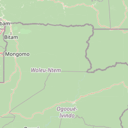
Map view of Mwangné National Park

Use this park location map to pinpoint Mwangné National Park in Gabon, understand its exact geographic position, and read its mapped placement within the surrounding landscape more clearly.

Pigeon | © OpenStreetMap contributors
Park atlas

Map Gabon's protected area geography, comparing Mwangné National Park with neighboring national parks and rainforest conservation zones.

Continue Your Discovery: Other Protected Areas and National Parks Near Mwangné National Park

After exploring Mwangné National Park, browse other national parks and protected areas throughout Gabon to understand Central Africa's vast protected landscapes. This geographic comparison of tropical forest ecosystems reveals regional conservation patterns and the interconnectedness of rainforest habitats within the Congo Basin.
National parkCuvette-Ouest Department
About 79 km away#1 closest

East

Odzala-Kokoua National Park National Park: Mapped Protected Landscape in Cuvette-Ouest

Explore its geographic boundaries and regional terrain.

Odzala-Kokoua National Park is a key national park entity, offering a distinct protected landscape within the Cuvette-Ouest Department. This page provides an atlas-style exploration of its mapped boundaries and geographic context. Delve into the specifics of this protected area to understand its contribution to the regional geography and natural landscape, facilitating structured discovery of its terrain.

Area
13,500 km²
Established
1935
IUCN
II
Visitors
50 annual
Biosphere reserveGabon
About 109 km away#2 closest

West

Ipassa-Makokou Biosphere Reserve: Gabon Geographic and Ecological Profile

Protected tropical lowland forest along the Ivindo River

Situated in northeastern Gabon, the Ipassa-Makokou Biosphere Reserve protects a vital segment of the Congolese-Guinean rainforest. This area provides deep insight into forest dynamics through decades of consistent monitoring, showcasing an unbroken canopy and high biodiversity density within a key Central African corridor.

Area
150 km²
Established
1983
National parkGabon
About 129 km away#3 closest

Northwest

Minkébé National Park: Protected Area and Geographic Context in Gabon

Explore the mapped terrain and protected landscape of this national park.

Gain a structured understanding of Minkébé National Park, a designated national park situated in Gabon. This destination focuses on the park's protected landscape, its distinct mapped boundaries, and its contribution to the regional geography of Central Africa. Examine how its protected status shapes the natural terrain and offers a unique angle for geographic discovery.

Area
7,570 km²
Established
2002
IUCN
II
Relief
Upland
National parkGabon
About 135 km away#4 closest

West

Ivindo National Park: A Protected Rainforest Landscape in Gabon

Explore its waterfalls, diverse ecosystems, and mapped geographic context.

Ivindo National Park represents a significant protected landscape within Gabon, spanning a vast area of intact tropical rainforest. Recognized as a UNESCO World Heritage Site, the park is defined by the Ivindo River and its dramatic waterfalls, including the famous Kongou and Mingouli Falls. Its geography includes mountainous terrain and vital riverine ecosystems, supporting critical populations of forest elephants and great apes. This page offers a gateway to understanding the park's protected status, its unique natural features, and its role in the broader geography of Central Africa.

Area
3,000 km²
Established
2002
IUCN
II
Relief
Mixed relief
National parkCameroon
About 206 km away#5 closest

North

Nki National Park: Protected National Park Landscape in Cameroon

Explore the geographic context and mapped boundaries.

Nki National Park is a designated national park in Cameroon, offering a distinct protected landscape for geographic study. This page provides essential context for understanding the park's place within the country's natural geography and protected areas atlas. Explore its mapped terrain and protected boundary details to gain a clearer picture of this natural entity within Central Africa's diverse geography.

Area
3,093 km²
Established
2005
IUCN
II
Relief
Upland
Watercolor painting of a landscape with grassy areas, a lake, and distant hills under a light sky
National parkGabon
About 233 km away#6 closest

Southwest

Lopé National Park: Gabon's Protected Landscape and National Park Geography

Explore mapped boundaries and natural terrain in Central Africa.

Delve into Lopé National Park, a designated national park situated in Gabon. This protected area serves as a crucial point for understanding the nation's geography and the distribution of its conservation landscapes. As an entry in the MoriAtlas, it offers a detailed view of its mapped territory and its contribution to the broader regional context of Central Africa, emphasizing its role in protected area atlas exploration.

Area
4,910 km²
Established
2002
IUCN
II
Relief
Mixed relief
National parkEast Province
About 245 km away#7 closest

Northeast

Boumba Bek National Park: National Park with Protected Landscape Identity in East Province

Explore its geographic context and mapped protected boundaries.

Boumba Bek National Park is a key protected area within Cameroon's East Province, offering a dedicated focus for understanding national park landscapes. This resource facilitates discovery of its precise geographic footprint and its significance as a mapped protected land. Users can delve into its regional context and explore the atlas-level details defining its protected status and natural landscape character.

Area
2,382 km²
Established
2005
IUCN
II
Relief
Lowland
Protected areaGabon
About 261 km away#8 closest

South

Parc de la Lékédi: Protected Area Geography and Landscape Context in Southeastern Gabon

A managed savanna and forest mosaic reserve in the Haut-Ogooué province.

Spanning 14,000 hectares of sandstone terrain, Parc de la Lékédi represents a distinct protected landscape in Gabon. The reserve merges conservation goals with scientific research on primates, utilizing a network of lakes and riverine corridors that support a high concentration of forest and savanna species in a highly managed, ecologically significant environment.

Area
140 km²
Established
1990
Relief
Upland
Climate
Tropical

Common questions about visiting, size, designation, and location context for Mwangné National Park

Mwangné National Park FAQs for park facts, access, geography, and protected area context

Find quick answers about Mwangné National Park, including protected-area facts, park geography, trail and visitor context, and how the park fits into its surrounding country and regional landscape.
MoriAtlas Explorer

Continue Your Protected Areas Search Across the Global Atlas

Deepen your exploration by continuing the structured search for national parks and protected areas worldwide. Utilize the comprehensive filtering capabilities to compare different conservation landscapes and refine your understanding of global park geography. Discover more about the distribution and characteristics of protected natural areas.

Global natural geography