
Mori Atlas logo
Nature reserveNaturschutzgebiet Oberlauf der Inde im Münsterwald

Mapping the headwater streams, boggy woodland, and wetland corridors near the Aachen city edge.

Naturschutzgebiet Oberlauf der Inde im Münsterwald Protected Landscape and Stream Geography

Naturschutzgebiet Oberlauf der Inde im Münsterwald encompasses a vital mosaic of rare wetland ecosystems and near-natural stream corridors along the upper reaches of the Inde and Fobisbach. This protected area in Germany preserves a unique landscape of moor sedge, alder carr, and spring mires that thrive in the waterlogged, nutrient-poor soils of the region. The terrain is defined by narrow, quiet valleys and small-scale relief changes that provide a rare, intact refuge for vegetation communities lost elsewhere in the surrounding urban and agricultural landscape.

stream valleyheadwater streamsalder carrmoor sedge forestwet oak-birch woodlandspring mire
A flat-design vector illustration of a mountain valley featuring a winding river, a waterfall in the distance, and surrounding coniferous forest.

Naturschutzgebiet Oberlauf der Inde im Münsterwald

Nature reserve

Park overview

Structured park overview, official facts, and landscape profile for Naturschutzgebiet Oberlauf der Inde im Münsterwald

Naturschutzgebiet Oberlauf der Inde im Münsterwald park facts, protected area profile, and essential visitor context

Review the core facts for Naturschutzgebiet Oberlauf der Inde im Münsterwald, including designation, size, terrain, visitor scale, habitats, and operating context in one park-focused overview.

About Naturschutzgebiet Oberlauf der Inde im Münsterwald

Naturschutzgebiet Oberlauf der Inde im Münsterwald is a focused, habitat-oriented nature reserve in the Städteregion Aachen, in the far west of North Rhine-Westphalia. It lies within the municipal area of Aachen, close to the Belgian border and west of the locality of Rott (Roetgen), occupying the upper catchment of the Inde river as well as parts of the nearby Prälatensief and the upper and middle course of the Fobisbach and several smaller tributary streams.

Although the reserve is modest in size, it is ecologically rich because of the unusual combination of hydrological conditions, soil chemistry, and topographic setting. Many sections of the stream valleys lie on poorly draining substrates that experience prolonged waterlogging and are extremely low in nutrients. These stagnant, acidic, and nutrient-limited conditions have prevented the development of more typical, productive forest types and instead favored relict plant communities of high conservation interest.

The reserve protects a continuous sequence of habitats running from the upper Inde headwaters, through the Prälatensief valley, into the Fobisbach system and its tributaries. Along this gradient, one encounters boggy alder woodland dominated by moor sedge, wet birch and oak forest, open spring-fed mires with very little tree cover, gravel banks in the broader valley sections, and small expanses of purple moor grass grassland. Steeper sections along the western side of the Fobisbach valley rise as a six- to seven-metre-high slope, adding topographic variation to an otherwise low-relief stream landscape.

Because the surrounding region has long been shaped by settlement, agriculture, and forestry, the existence of such an intact, ecologically coherent headwater system close to the city of Aachen gives the nature reserve particular scientific and regional value. The protected area is managed under the landscape plan (Landschaftsplan) of the city of Aachen by the lower landscape authority (Untere Landschaftsbehörde) of the Städteregion Aachen, and it forms part of the broader network of protected sites around Aachen that together aim to preserve representative elements of the region's natural heritage.

Quick facts and research context for Naturschutzgebiet Oberlauf der Inde im Münsterwald

The reserve lies in the Städteregion Aachen in the German state of North Rhine-Westphalia, west of Aachen near the Belgian border. It covers about 29.9 hectares and is classified under IUCN Category IV as a Habitat/Species Management Area. Designated in 1988, it carries the official identifier ACS-007 and is listed in the World Database on Protected Areas under ID 164896.

Protection and recognition

Explore documented terrestrial protection metrics and regulatory context.

Naturschutzgebiet Oberlauf der Inde im Münsterwald Protection Status

Terrestrial protection status for Naturschutzgebiet Oberlauf der Inde im Münsterwald outlines official designation metrics and management scope within the protected area network. Recorded database attributes summarize conservation parameters without additional international recognitions or transboundary borders.

Protection details

Protection scope
Terrestrial
Transboundary protection
No
WDPA ID
164896
Park context

Deeper park guide and search-rich context for Naturschutzgebiet Oberlauf der Inde im Münsterwald

Naturschutzgebiet Oberlauf der Inde im Münsterwald history, landscape, wildlife, and travel context

Explore Naturschutzgebiet Oberlauf der Inde im Münsterwald through its history, landscape character, ecosystems, wildlife, conservation priorities, cultural context, and seasonal travel timing in a structured park guide built for atlas discovery and search intent.

Why Naturschutzgebiet Oberlauf der Inde im Münsterwald stands out

The reserve is best known for its near-natural headwater streams of the Inde and Fobisbach and the associated rare wetland communities that have developed on waterlogged, nutrient-poor soils. The most distinctive feature is the moor sedge and alder carr forest, complemented by wet oak-birch valley woodland, spring mires, and small Molinia wet grasslands. Its proximity to Aachen, combined with the unusually intact character of the stream valleys and the presence of spring bogs, gives the reserve an importance beyond its small size. It functions as a refuge for vegetation types that have largely disappeared from the surrounding agricultural and urban landscape of the Aachen region.
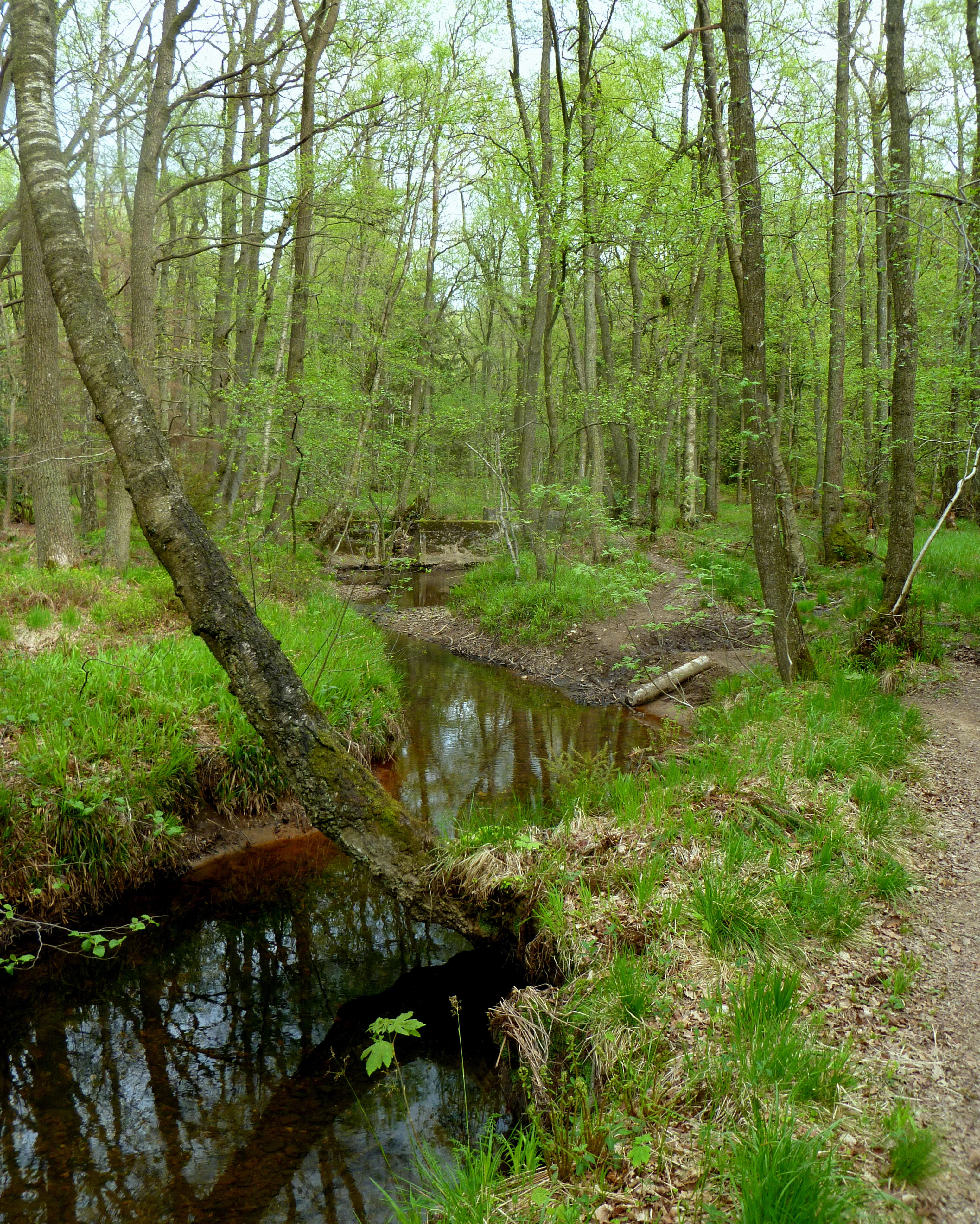
A small, dark, winding stream flows through a dense forest with light green spring foliage, featuring a leaning tree over the water and a narrow dirt path along the bank.
A view of the upper Inde river as it flows through the lush greenery of the Münsterwald nature reserve.

Naturschutzgebiet Oberlauf der Inde im Münsterwald history and protected-area timeline

The nature reserve was formally designated in 1988, when the area around the upper Inde and parts of the Münstereifel-area stream system was placed under protection to conserve its near-natural stream courses and rare plant communities. Its designation was driven by the recognition that boggy alder woodland, spring mires, and wet oak-birch valley forest had become exceptionally rare in the broader Aachen region, and that continued protection was needed for scientific, regional, and ecological reasons.

The reserve has been managed within the framework of the city of Aachen's landscape plan (Landschaftsplan) and administered by the lower landscape authority (Untere Landschaftsbehörde) of the Städteregion Aachen. Its official identifier in the North Rhine-Westphalia nature protection information system is ACS-007, and it is recorded internationally under World Database on Protected Areas ID 164896 as an IUCN Category IV Habitat/Species Management Area.

Naturschutzgebiet Oberlauf der Inde im Münsterwald landscape and geographic character

The landscape of the reserve is a quiet, low-relief headwater terrain shaped by narrow stream valleys and boggy depressions rather than dramatic topography. The protected area follows the upper course of the Inde and parts of the Prälatensief and the Fobisbach, with several smaller tributary streams and spring areas feeding into the main channels. Soils throughout much of the reserve are characterized by waterlogging and very low nutrient availability, producing conditions in which boggy vegetation can persist.

In the northern part of the Fobisbach biotope, the valley floor opens into a shallow basin that contains a mix of wet and relatively dry old channel sections, partial gravel banks, and the active stream bed. The southern Inde valley shows a different character: a drier oak-birch forest that loosens near the Prälatensief and is enriched with scattered pines. A tributary entering from the southwest flows through a small open bog with few trees, before the system broadens again into a larger moor sedge and alder carr complex further downstream.

On the western side of the Fobisbach valley, a more pronounced steep slope rises roughly six to seven metres above the stream, creating a short but noticeable change in relief before the valley opens again into a broader wet zone. The overall impression is one of a mosaic of small, closely spaced landscape units: stream channels, seepage slopes, wet woodland, spring mires, and tiny patches of grassy wetland, all very close to the Belgian border.

Naturschutzgebiet Oberlauf der Inde im Münsterwald ecosystems, habitats, and plant life

The ecological character of the reserve is defined by streamside and boggy habitats whose composition is controlled primarily by water and nutrient conditions rather than by climate alone. Because waterlogging is widespread and nutrient availability extremely low, the vegetation is dominated by species adapted to acidic, peat-influenced conditions. This has allowed plant communities to survive here that have largely vanished from the surrounding intensively used land.

The centrepiece of the reserve is a moor sedge and alder carr community (Moorseggen-Erlenbruch), a rare boggy woodland type in which alder trees grow alongside a ground layer dominated by sedges and Sphagnum mosses. Adjacent to this, in the broader valley sections, are wet oak-birch forests and alder-birch woodlands, while more open sections support small Molinia grasslands and an unusual spring-fed bog with very little tree cover. The original stream channels and remnant old channels also create patches of varying wetness that contribute habitat diversity.

Altogether, the reserve functions as a small but unusually complete example of the ecological gradients that characterize near-natural headwater systems in this part of western Germany: from active spring mires through boggy alder woodland into more developed oak-birch forests, and across to small patches of wet grassland derived from open mire.

Naturschutzgebiet Oberlauf der Inde im Münsterwald wildlife and species highlights

The nature reserve is primarily recognized at the level of its habitat mosaics and plant communities rather than for a particular list of charismatic mammal or bird species. The headwater stream corridors, boggy alder woodland, and open spring mires provide habitat elements typical of small lowland stream valleys in western Germany: shaded, humid woodland with rich leaf-litter and deadwood, wet meadows and grasslands, and open water in the form of springs and small ditches.

Such conditions tend to support amphibians, invertebrates, and stream organisms that depend on clean, near-natural headwater environments, as well as woodland and wetland birdlife typical of the Aachen region. The reserve's conservation interest, however, is focused on the vegetation structure and the integrity of the stream system as a whole rather than on any single flagship species.

Naturschutzgebiet Oberlauf der Inde im Münsterwald conservation status and protection priorities

The reserve's conservation significance lies in the protection of near-natural headwater streams of the Inde and Fobisbach and the plant communities that depend on them. Its formal protection objectives include preserving rare alder carr forest with moor sedge, wet oak-birch forest, purple moor grass meadows, and a spring-fed bog whose flora is of particular phytogeographical interest.

The protection order recognizes that the area's special ecological character derives from the combination of stagnant, nutrient-poor, acidic soils, intact valley morphology, and continuity of wet habitat conditions over time. Continued protection is considered important both for scientific reasons, to study and document an unusually complete set of stream valley habitats, and for regional reasons, because these vegetation types have become very rare in the heavily modified landscape of the Aachen region. The reserve is classified under IUCN Category IV, reflecting its role as a Habitat/Species Management Area maintained through active measures rather than a strictly undisturbed wilderness.

Naturschutzgebiet Oberlauf der Inde im Münsterwald cultural meaning and human context

The reserve lies within the historic area around Aachen, a region with deep cultural roots and a long history of settlement, agriculture, and woodland management. The small stream valleys of the upper Inde and Fobisbach have been used and shaped by humans for centuries, and the surrounding landscape combines fragments of older woodland with pastures, small farm settlements, and dispersed hamlets.

Its present-day identity as a protected nature reserve reflects a regional effort, embedded in the city's landscape planning, to retain an ecologically meaningful remnant of the headwater landscape that once covered much of this part of the Eifel foothills before widespread land conversion. The area is part of a broader network of protected sites within the Städteregion Aachen that together aim to safeguard representative examples of the region's natural and cultural landscape.

Top sights and standout views in Naturschutzgebiet Oberlauf der Inde im Münsterwald

The reserve's standout features are its moor sedge and alder carr woodland, its near-natural upper Inde and Fobisbach stream corridors, and the unusually intact spring-fed bog and Molinia wet grasslands that occur within a very small area. The compact valley landscape, with wet woodland, open boggy patches, steep slopes, and gravel-bedded stream sections, gives the protected area an ecologically dense character that is unusual so close to a large city like Aachen.

Best time to visit Naturschutzgebiet Oberlauf der Inde im Münsterwald

Because the reserve is a small, woodland- and wetland-dominated protected area focused on stream valleys and boggy forests, it does not have a strongly seasonal visitor profile. Late spring and early summer tend to be the most rewarding periods for observing the variety of wetland plants and the structure of the vegetation, when sedges, mosses, and wet woodland ground layers are most active. Late summer and early autumn emphasize the colour of purple moor grass and the changing tones of birch and oak foliage. Wet, muddy conditions can be expected on the valley floor in any season, reflecting the very nature of the habitats being protected.

Monthly climate preview

Long-term monthly temperature and precipitation patterns recorded at a representative coordinate

Naturschutzgebiet Oberlauf der Inde im Münsterwald Climate and Average Temperature Normals

Representative point measurements reveal the annual temperature and precipitation rhythm across twelve months at Naturschutzgebiet Oberlauf der Inde im Münsterwald. Examining the complete monthly climate normals provides deeper context regarding long-term thermal variations and precipitation distribution.
Annual mean8 °C
0 °C17 °C
Jan
Feb
Mar
Apr
May11°
Jun15°
Jul17°
Aug17°
Sep13°
Oct
Nov
Dec
Warmest month
July

17 °C

Coolest month
January

-0 °C

Wettest month
December

3.1 mm/day

Driest month
April

1.9 mm/day

Park location guide

Geography guide, regional context, and park location map for Naturschutzgebiet Oberlauf der Inde im Münsterwald

Naturschutzgebiet Oberlauf der Inde im Münsterwald park geography, regions, and map view in Germany

Understand where Naturschutzgebiet Oberlauf der Inde im Münsterwald sits in Germany through a broader geographic reading of the surrounding landscape, nearby location context, and its mapped position within the national park landscape.

How Naturschutzgebiet Oberlauf der Inde im Münsterwald fits into Germany

Germany is a federal republic in Western and Central Europe with a population of over 83 million across sixteen constituent states. It is Europe's largest economy by nominal GDP and a major global exporter and importer. The capital is Berlin, and the country borders Denmark, Poland, Czech Republic, Austria, Switzerland, France, Luxembourg, Belgium, and the Netherlands.

Wider geography shaping Naturschutzgebiet Oberlauf der Inde im Münsterwald in Germany

Germany is located in Western and Central Europe, spanning 357,022 km². It borders Denmark to the north, Poland and the Czech Republic to the east, Austria and Switzerland to the south, and France, Luxembourg, Belgium, and the Netherlands to the west. The country has coastlines on the Baltic Sea and North Sea to the north, with the Alps located in the southern region.

Map view of Naturschutzgebiet Oberlauf der Inde im Münsterwald

Use this park location map to pinpoint Naturschutzgebiet Oberlauf der Inde im Münsterwald in Germany, understand its exact geographic position, and read its mapped placement within the surrounding landscape more clearly.

Pigeon | © OpenStreetMap contributors

Visualizing headwater stream valleys, alder carr, and protected wetland habitats

Naturschutzgebiet Oberlauf der Inde im Münsterwald Photos and Landscapes

Visual documentation captures the quiet stream corridors, waterlogged depressions, and rare woodland communities that define the protected area. Examining field photographs helps researchers and visitors understand the distinctive low relief and intact riparian habitats of the Aachen region.

A small, dark, winding stream flows through a dense forest with light green spring foliage, featuring a leaning tree over the water and a narrow dirt path along the bank.

Park atlas

Compare adjacent stream valleys, headwater terrains, and regional protected landscapes.

Other Parks and Protected Areas Near Naturschutzgebiet Oberlauf der Inde im Münsterwald

Users can browse other protected areas and nearby nature reserves situated throughout the surrounding border region. Comparing adjacent stream valleys and headwater biotopes expands regional geographic context beyond Naturschutzgebiet Oberlauf der Inde im Münsterwald.
A horizontal watercolor illustration depicting rolling, soft-toned hills and a line of stylized trees in greens and pinks against a white background.
Nature reserveNordrhein-Westfalen
About 2.8 km away#1 closest

North

Naturschutzgebiet Schmithof: A Geological and Ecological Protected Area in Nordrhein-Westfalen

Mapped limestone quarries and traditional coppice forest landscapes

Located within the Städteregion Aachen, Naturschutzgebiet Schmithof protects a significant conjunction of geological and biological values. The site features an abandoned limestone quarry set against a backdrop of historic oak-hornbeam forest. This reserve provides a clear window into the local terrain, where calcareous grassland soils support rare flora and reflect ongoing habitat succession within a protected landscape context.

Area
0.048 km²
Established
1988
IUCN
IV
Relief
Lowland
A watercolor painting depicting rolling, soft-toned green hills and a foreground of trees and riparian vegetation.
Nature reserveNorth Rhine-Westphalia
About 5.9 km away#2 closest

East

Laubwald am Hasselbachgraben Nature Reserve in North Rhine-Westphalia

Protected Eifel forest and riparian stream landscape

Located in the Städteregion Aachen, Laubwald am Hasselbachgraben preserves a distinct mix of European beech, oak, and spruce. The reserve is anchored by the Hasselbach stream valley and the landmark Kreitzberg Naturwaldzelle, providing a critical study of near-natural woodland structure within the northern Eifel region.

Area
2.88 km²
Established
1999
IUCN
IV
Relief
Upland
A watercolor painting showing a soft, pastel-colored landscape with a wetland in the foreground and gentle, rolling hills in the background.
Nature reserveNordrhein-Westfalen
About 7 km away#3 closest

Southeast

Hoscheider Venn mit Quellgebieten des Dreiläger- und Schleebaches Nature Reserve Atlas

Protected raised bog and glacial pingo terrain in North Rhine-Westphalia

Hoscheider Venn mit Quellgebieten des Dreiläger- und Schleebaches safeguards a representative upland moor environment on the western edge of the Eifel. The reserve includes diverse habitats ranging from nutrient poor bog pools to acidophilous forests, maintaining active restoration zones for regenerating wet heath and peatland ecosystems across its unique topographic mosaic.

Area
1.96 km²
Established
1982
IUCN
IV
Relief
Upland
A wide panoramic watercolor painting showing a landscape with a winding light green river or meadow in the foreground, a band of green trees in the middle ground, and purple mountains in the background against a white sky.
Nature reserveNordrhein-Westfalen
About 7.1 km away#4 closest

Northeast

Naturschutzgebiet Schomet: Mapping the Protected Limestone Ridge and Reclaimed Quarry Landscapes

Nature reserve geography in Stolberg, Nordrhein-Westfalen

Examine the distinct geomorphology of Naturschutzgebiet Schomet, where abandoned Carboniferous limestone quarries have evolved into sheltered refuges for hornbeam forest and spring flora. This protected area offers insight into the regional geology of the Eifel foothills, showcasing how human-modified landscapes serve as important ecological corridors for amphibians and rare butterfly species within the broader Stolberg municipal network.

Area
12.81 km²
Established
2005
IUCN
IV
Nature reserveNorth Rhine-Westphalia
About 8.1 km away#5 closest

Southeast

Wollerscheider Venn: Mapping the Protected Peatland and Bog Terrain of North Rhine-Westphalia

A specialized wetland reserve on the Eifel border high plateau

Located in the municipality of Simmerath, Wollerscheider Venn preserves essential fragments of raised bog and swamp woodland within the larger Hohes Venn ecosystem. This reserve protects diverse habitats including juniper heath and Nardus grassland, serving as a critical refuge for bog-specialist butterflies and dragonflies in the Eifel region. Its mapped landscape offers a clear view into the conservation of rare peatland environments across western Germany.

Area
0.42 km²
Established
1961
IUCN
IV
Nature reserveGermany
About 9.1 km away#6 closest

Northwest

Wurmtal Nature Reserve: Mapping the Protected River Valley and Floodplain Geography

Protected riparian habitat in North Rhine-Westphalia

Wurmtal protects a diverse river corridor characterized by free-meandering stretches, soft-wood floodplain forests, and distinct industrial-heritage landmarks. This atlas entry provides insight into the valley's structural geography, including its steep erosion cliffs, gravel-bed river dynamics, and role as a significant ecological migration route within the regional landscape.

Established
1989
Relief
Lowland
Scope
Terrestrial
Water
Water-dominated
A watercolor painting showing a soft green landscape with rolling hills, a small pond, and trees under a white background.
Nature reserveStädteregion Aachen
About 9.2 km away#7 closest

Northeast

Naturschutzgebiet Schlangenberg: A Geographic Profile of Protected Mining Landscapes

Rare heavy metal habitats in the Städteregion Aachen

Naturschutzgebiet Schlangenberg serves as a protected ecological island featuring specialized Galmei flora that thrives on toxic zinc-rich soils. The reserve offers a clear look at how geological formation and historic mining practices created a unique steppe-like terrain, supporting diverse butterfly populations and rare botanical species within the North Rhine-Westphalia landscape.

Area
1.237 km²
Established
1975
IUCN
IV
Relief
Upland
Watercolor painting of a rolling stream valley with soft green hills and light water
Nature reserveStädteregion Aachen
About 9.8 km away#8 closest

East

Kelzer- und Saarscher Bachtal: Protected Brook Valley Geography and Forest Terrain

Nature reserve exploration in the Städteregion Aachen landscape

The Kelzer- und Saarscher Bachtal nature reserve protects a vital network of brook valley habitats, including deciduous forest remnants, wet heath, and cascading stream sections. This area offers a clear look at local hydrologic restoration and the structural diversity found within the Eifel district, providing a focused view for those interested in regional protected-land geography.

Area
0.46 km²
Established
1999
IUCN
IV

Common questions about visiting, size, designation, and location context for Naturschutzgebiet Oberlauf der Inde im Münsterwald

Naturschutzgebiet Oberlauf der Inde im Münsterwald FAQs for park facts, access, geography, and protected area context

Find quick answers about Naturschutzgebiet Oberlauf der Inde im Münsterwald, including protected-area facts, park geography, trail and visitor context, and how the park fits into its surrounding country and regional landscape.
MoriAtlas Explorer

Continue Your Protected Areas Search Across the Global Atlas

Deepen your exploration by continuing the structured search for national parks and protected areas worldwide. Utilize the comprehensive filtering capabilities to compare different conservation landscapes and refine your understanding of global park geography. Discover more about the distribution and characteristics of protected natural areas.

Global natural geography