Mori Atlas logo
Protected areaOchoco National Forest

A diverse transition zone of rimrock canyons, pine forests, and volcanic terrain in the Ochoco Mountains.

Ochoco National Forest: Mapping the Protected Landscapes and High Desert Geography of Central Oregon

Spanning over 850,000 acres in Central Oregon, Ochoco National Forest serves as an ecologically significant corridor connecting the Cascade Range with the arid Columbia Plateau. This protected area features a unique mosaic of ponderosa pine stands, juniper woodlands, and rugged rimrock plateaus. Beyond its forested slopes, the terrain transitions into high desert country, encompassing the headwaters of the North Fork Crooked River and three distinct wilderness areas that safeguard essential wildlife winter range.

national forestOchoco MountainsCentral Oregonhigh desertrimrockponderosa pine

Ochoco National Forest

Protected area

Park overview

Structured park overview, official facts, and landscape profile for Ochoco National Forest

Ochoco National Forest park facts, protected area profile, and essential visitor context

Review the core facts for Ochoco National Forest, including designation, size, terrain, visitor scale, habitats, and operating context in one park-focused overview.

About Ochoco National Forest

Ochoco National Forest is one of the principal U.S. national forests in Central Oregon, covering approximately 851,033 acres of the Ochoco Mountains, in addition to administering the Crooked River National Grassland in neighbouring Jefferson County. The forest stretches across Crook, Harney, Wheeler, and Grant counties, with its administrative headquarters in Prineville, the nearest incorporated city in the region. Mitchell is also commonly cited as a gateway community for visitors approaching the forest.

Landscape-wise, the Ochoco is distinctive because it does not fit cleanly into one ecological category. In some areas it reads as a classic pine-clad mountain forest dominated by ponderosa pine, while just a short distance away the terrain opens into arid plateaus, sagebrush flats, rimrock canyons, and exposed volcanic rock formations. This range of conditions, combined with the headwaters of the North Fork Crooked River, gives the forest an unusually varied character for an inland Oregon protected landscape.

Established in 1911, the forest has long served as both a working landscape and a recreation destination. Its three designated wilderness areas, Mill Creek Wilderness, Bridge Creek Wilderness, and Black Canyon Wilderness, account for roughly 36,200 acres of the more protected core, while the surrounding forest supports a wider network of trails, campgrounds, and backcountry routes. Together with the Crooked River National Grassland, the forest forms an important continuous block of public land in the central part of the state.

For wildlife, the Ochoco occupies a recognized position in Oregon's broader conservation framework. The Oregon Conservation Strategy, maintained by the Oregon Department of Fish and Wildlife, lists several species of interest that are tied to the forest, including the Pacific marten, wolverine, ferruginous hawk, greater sage grouse, and pileated woodpecker. Big game species, particularly mule deer and elk, depend on parts of the forest as winter range, a fact that has shaped both ecological priorities and access rules within the forest.

Quick facts and research context for Ochoco National Forest

Ochoco National Forest is a U.S. national forest located in the Ochoco Mountains of Central Oregon, just north and east of Prineville. It spans about 851,033 acres, with the bulk of its land within Crook County and additional holdings in Harney, Wheeler, and Grant counties.

Established on July 1, 1911, the forest is managed by the U.S. Forest Service and contains three wilderness areas totalling roughly 36,200 acres. It also administers the separate Crooked River National Grassland in Jefferson County, an arrangement that ties together forest, grassland, and high country under one management umbrella.

Protection and recognition

Examine the documented terrestrial protection scope and conservation status records

Ochoco National Forest Protection Status and International Recognition Data

Ochoco National Forest brings together documented protection status records and terrestrial management scope data for this protected area. Review the structured administrative designations and recognized conservation boundaries associated with this forest landscape.

Protection details

Protection scope
Terrestrial
Park context

Deeper park guide and search-rich context for Ochoco National Forest

Ochoco National Forest history, landscape, wildlife, and travel context

Explore Ochoco National Forest through its history, landscape character, ecosystems, wildlife, conservation priorities, cultural context, and seasonal travel timing in a structured park guide built for atlas discovery and search intent.

Why Ochoco National Forest stands out

The Ochoco National Forest is best known for its unusual mix of high desert terrain, deeply carved rimrock canyons, and surprisingly dense pine stands in the Ochoco Mountains. Geologic oddities such as the towering column of Steins Pillar are part of the area's visual identity, and the forest's role as winter range for mule deer and elk makes it a recognized habitat for big game species in Central Oregon. It is also recognized as a transition zone between the wetter ponderosa pine country of the Cascades and the sagebrush steppe of the broader Oregon high desert, supporting species such as the greater sage grouse, ferruginous hawk, pileated woodpecker, and the rare Pacific marten.
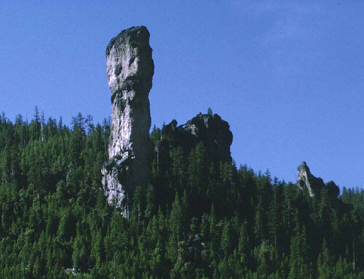
A tall, vertical rock pillar known as Steins Pillar stands prominently above a hillside covered in evergreen forest under a clear blue sky.
Steins Pillar, a prominent volcanic rock formation rising above a dense pine forest in Ochoco National Forest.

Ochoco National Forest history and protected-area timeline

The Ochoco National Forest was officially established on July 1, 1911, carving out a substantial block of public land in Central Oregon's Ochoco Mountains as part of the early twentieth century effort to manage and protect the western forests under federal oversight. From its beginnings the forest combined mountain pine country with broader arid and semi-arid terrain, an unusual feature that has remained central to its identity ever since.

Over time the agency footprint evolved. The forest was organised into ranger districts to make management and public access workable across its large geographic spread, and at one point a Snow Mountain Ranger District existed within the Ochoco before being transferred to the neighbouring Malheur National Forest and reorganised as part of the Emigrant Creek Ranger District. Today the forest operates through the Lookout Mountain Ranger District and the Paulina Ranger District, both based in Prineville, plus the Crooked River Grasslands District based in Madras.

The addition of the Crooked River National Grassland to the forest's administrative responsibility further shaped its present-day role, giving the Ochoco management authority over both forested high country and the adjacent open grassland landscape in Jefferson County. A 1993 Forest Service study also documented roughly 95,000 acres of old growth forest within the forest, establishing a baseline for ongoing discussions about habitat, fire ecology, and long-term forest conservation.

Ochoco National Forest landscape and geographic character

The landscape of Ochoco National Forest is shaped by the Ochoco Mountains and the broader transition between Central Oregon's pine country and its high desert. The terrain includes exposed rimrock, deeply cut canyons, and isolated rock formations such as the well-known Steins Pillar, surrounded by a mosaic of ponderosa pine, juniper woodland, lodgepole stands, and open sage flats. The result is a forest that, unlike many other national forests, often opens suddenly into dry, rocky country rather than rolling into continuous tree cover.

Outside the main forested slopes the land spreads out into high desert plateaus and grasslands, an arid character that has long defined the rimrock country of this part of Central Oregon. The forest contains the headwaters of the North Fork Crooked River, placing it at the upper end of a watershed that ultimately drains into the larger Crooked River system of the region.

The forest's three designated wilderness areas, Mill Creek, Bridge Creek, and Black Canyon, together protect about 36,200 acres of the more rugged interior, where steep slopes and erosion-carved rock features create some of the most visually striking ground in the Ochoco Mountains. Together the managed districts, wilderness areas, and the neighbouring Crooked River National Grassland form a continuous sweep of contrast: shady pine draws, bare volcanic ridges, sweeping grasslands, and deeply incised river canyons.

Ochoco National Forest ecosystems, habitats, and plant life

Ecologically, Ochoco National Forest sits at the meeting point of the forested east slope of the Oregon Cascades and the drier Columbia Plateau. Ponderosa pine is the signature tree, often mixed with lodgepole pine and juniper, while the lower and drier elevations transition into sagebrush and bunchgrass communities that link the forested highlands with the adjacent high desert. This combination gives the forest a wide range of habitats within a relatively compact geographic area.

Parts of the forest retain substantial old growth; a 1993 Forest Service study identified roughly 95,000 acres of old growth within the forest, providing important structural complexity and habitat value. These older stands are particularly significant for species that depend on large, mature trees and the cooler, moister microclimates they create, while the open, drier slopes support very different plant communities and wildlife patterns.

The Crooked River National Grassland, administered alongside the forest, extends the ecological range even further into shrub-steppe grassland. Together, the forest and grassland create a connected mosaic of pine, juniper, canyon, and sage habitats that is relatively unusual within the National Forest System and that shapes the distribution of wildlife across the region.

Ochoco National Forest wildlife and species highlights

Wildlife is one of the defining elements of the Ochoco National Forest. Large portions of the forest serve as winter range for mule deer and elk, and seasonal motorised vehicle restrictions from December through May are in place specifically to protect these animals during their most vulnerable period. As a result, big game viewing and hunting are embedded in the forest's identity and management approach.

The forest also supports a notable list of species highlighted in the Oregon Conservation Strategy under the Oregon Department of Fish and Wildlife. These include the Pacific marten, a forest-dwelling carnivore associated with mature and old growth coniferous habitat; the wolverine, a wide-ranging species of conservation interest; the ferruginous hawk, an open-country raptor tied to the forest's drier terrain; the greater sage grouse, a sagebrush-dependent grouse that links the forested mountains to the adjacent high desert; and the pileated woodpecker, an indicator of older forest structure.

Birdlife more broadly is rich because of the forest's mix of habitats. Pine forests host woodpeckers, nuthatches, and forest songbirds, while the sage flats and canyon edges support raptors, upland game birds, and grassland species. The combination of dense pine cover, exposed rimrock, and open sage steppe gives the Ochoco a particularly varied bird profile for an inland Oregon forest.

Ochoco National Forest conservation status and protection priorities

Ochoco National Forest holds meaningful conservation value for Central Oregon, sitting within a recognised landscape of the Oregon Conservation Strategy. Its mix of montane pine forest, old growth stands, canyon habitats, and adjacent sagebrush steppe supports species of conservation interest such as the Pacific marten, wolverine, ferruginous hawk, greater sage grouse, and pileated woodpecker, all of which depend on specific habitat conditions that the forest continues to provide.

The forest's role as winter range for mule deer and elk makes it functionally important for big game populations that use it seasonally. The closure of sections of the forest to motorised vehicles between December and May reflects how strongly the area's conservation framework is tied to the protection of these ungulates during the cold months, when they are most sensitive to disturbance.

A 1993 Forest Service study identified roughly 95,000 acres of old growth within the forest, a figure that continues to shape conversations about fire ecology, habitat resilience, and long-term forest management. Combined with three designated wilderness areas totalling about 36,200 acres and the adjoining Crooked River National Grassland, the Ochoco contributes to a large and ecologically connected block of public land in the interior of Oregon.

Ochoco National Forest cultural meaning and human context

The Ochoco National Forest occupies a region of Central Oregon where ranching, timber, and outdoor recreation have long been part of the local identity. Prineville, the nearest major town and headquarters of the forest, has historically been a hub for cattle ranching and logging in the broader Crook County area, and those land uses have shaped how the surrounding national forest is both valued and managed.

The forest's recreational traditions reflect the area's rural character. Hiking, horseback riding, hunting, fishing, camping, and rock hounding are all tied to longstanding regional ways of engaging with the land, and the relatively undeveloped nature of much of the forest has supported a quiet, dispersed style of public use rather than heavy tourism infrastructure. Stargazing and birding have grown in popularity as more visitors seek out the forest's dark skies and varied habitat.

Top sights and standout views in Ochoco National Forest

Within the roughly 851,033 acres of the Ochoco National Forest, three wilderness areas, Mill Creek, Bridge Creek, and Black Canyon, form the heart of its most protected terrain, together covering about 36,200 acres of rugged canyon and pine country. Surrounding these wilderness cores, the broader forest stretches across the Ochoco Mountains into rimrock canyons, sage flats, and the headwaters of the North Fork Crooked River.

Visitors come to the Ochoco for a combination of accessible outdoor recreation and the unusual visual contrast between dense pine forest and arid high desert landforms, with landmarks like Steins Pillar offering a striking focal point. The forest's importance as winter range for mule deer and elk, combined with its role in the Oregon Conservation Strategy for species such as the Pacific marten and greater sage grouse, gives it significant ecological weight beyond its recreational appeal.

Best time to visit Ochoco National Forest

Summer is generally the most comfortable season for exploring the Ochoco National Forest, when snow has receded from most roads and trails, wildflowers appear in the meadows, and the high desert portions of the forest become accessible to hiking, camping, and rock hounding. Warm, dry conditions make it easier to travel between the forested zones and the more exposed rimrock and canyon country.

Late spring and early autumn can also be rewarding, with cooler temperatures, active wildlife, and softer light for photography, though visitors should be prepared for rapidly changing weather at higher elevations. Winter brings the forest into its role as critical habitat for mule deer and elk, and motorised access to portions of the forest is restricted from December through May to protect these herds, meaning that winter visits typically require more planning and a focus on non-motorised recreation.

Monthly climate preview

Long-term temperature ranges and monthly precipitation averages for Ochoco National Forest

Ochoco National Forest Climate Normals and Annual Weather Patterns

Representative coordinate records show measured annual temperature swings and monthly precipitation rates spanning historical climatology periods. Detailed month-by-month climate profiles provide comprehensive long-term atmospheric data for thorough environmental analysis.
Annual mean8 °C
-2 °C20 °C
Jan-1°
Feb
Mar
Apr
May11°
Jun15°
Jul20°
Aug19°
Sep15°
Oct
Nov
Dec-2°
Warmest month
July

19.6 °C

Coolest month
December

-1.6 °C

Wettest month
December

1.9 mm/day

Driest month
August

0.4 mm/day

Park location guide

Geography guide, regional context, and park location map for Ochoco National Forest

Ochoco National Forest park geography, regions, and map view in United States of America

Understand where Ochoco National Forest sits in United States of America through a broader geographic reading of the surrounding landscape, nearby location context, and its mapped position within the national park landscape.

How Ochoco National Forest fits into United States of America

The United States of America is a federal presidential republic and one of the world's largest countries by area and population. It consists of 50 states across a vast territory spanning multiple time zones, with its capital in Washington, D.C. and largest city in New York City. The nation has a diverse economy, influential political system, and significant cultural and military presence globally.

Wider geography shaping Ochoco National Forest in United States of America

The United States occupies a vast territory in North America, bordered by Canada to the north and Mexico to the south. The 48 contiguous states stretch from the Atlantic to the Pacific Ocean, while Alaska occupies the northwestern region and Hawaii is an archipelago in the Pacific. The country encompasses diverse terrain including the Rocky Mountains, Appalachian Mountains, Great Plains, and extensive river systems.

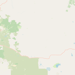
Map view of Ochoco National Forest

Use this park location map to pinpoint Ochoco National Forest in United States of America, understand its exact geographic position, and read its mapped placement within the surrounding landscape more clearly.

Pigeon | © OpenStreetMap contributors

Location context for Ochoco National Forest

Oregon

Visualizing the rimrock canyons, dense pine stands, and high desert terrain of the Ochoco Mountains.

Ochoco National Forest Photos and Scenery: Exploring the Landscapes of Central Oregon

Visual documentation captures the striking contrast between shaded ponderosa pine forests and arid volcanic plateaus across the Ochoco Mountains. Studying these field images reveals the rugged geological character, native habitats, and protected landscapes defining Central Oregon's high desert transition zone.

A tall, vertical rock pillar known as Steins Pillar stands prominently above a hillside covered in evergreen forest under a clear blue sky.

Park atlas

Discover related regional protected areas and connected high desert environments

Exploring Parks Near Ochoco National Forest and Surrounding Protected Landscapes

Browsing other protected areas near Ochoco National Forest reveals the complex transition zones linking Oregon pine country to high desert plateaus. Comparing adjacent reserves helps trace regional watershed corridors, wildlife migration ranges, and varied volcanic terrain across Central Oregon.
A soft watercolor painting of a landscape featuring the Twin Pillars volcanic rock formations in the distance, set against rolling green hills and pine forests.
Wildlife reserveOregon
Park boundaries overlap#1 closest

West

Mill Creek Wilderness: A Comprehensive Geographic Overview of Central Oregon Protected Land

Volcanic geology, canyon topography, and forest ecosystems in Oregon

Mill Creek Wilderness represents a significant protected unit within central Oregon, defined by its complex network of canyons and high-elevation plateaus. The area showcases a unique combination of old-growth ponderosa pine stands, lodgepole pine meadows, and striking volcanic plugs like the Twin Pillars. Its mapped terrain provides essential context for understanding the hydrology and geological evolution of the broader Ochoco mountain range.

Area
70.4 km²
Established
1984
IUCN
Ib
Relief
Mountain
A horizontal watercolor painting showing a panoramic view of layered green and purple mountains under a pale sky, with coniferous trees in the foreground.
Protected landscapeOregon
4.8 km away#2 closest

East

Malheur National Forest: Exploring Oregon's Vast Protected Mountain and Desert Landscape

A geographic study of the Blue Mountains and high desert terrain

Spanning over 1.4 million acres, Malheur National Forest represents a complex protected landscape in eastern Oregon. Its geography is defined by a central spine of the Strawberry Mountains, creating a transition zone between arid high desert ecosystems and dense coniferous forests. Known for large wilderness areas and extensive old growth stands, this forest serves as a vital point for understanding the interplay between topographic elevation and regional climate in the Pacific Northwest.

Area
5,929.81 km²
Established
1908
Visitors
242K annual
Relief
Mountain
A horizontal watercolor illustration showing a landscape with soft rolling mountains in the distance, a line of pine trees in the midground, and a grassy shoreline in the foreground.
Wildlife reserveOregon
70 km away#3 closest

West

Mount Washington Wilderness: Volcanic Geology and Forested Cascade Terrain

A mapped overview of Oregon protected volcanic landscapes.

Mount Washington Wilderness offers a stark and compelling geological study of Oregon's central Cascades. From the shield volcano's basaltic remnants to the fragmented cinder cones of Belknap Crater, the area provides a window into explosive and effusive volcanic activity. Our geographic data maps the transition of conifer forests and subalpine zones across its rocky, lake-dotted interior, highlighting the unique character of this quiet protected preserve.

Area
219.66 km²
Established
1964
IUCN
Ib
Relief
Mountain
Protected landscapeOregon
72 km away#4 closest

West

Willamette National Forest: Geography and Protected Landscapes of the Central Oregon Cascades

Mapped terrain, old-growth forests, and protected wilderness boundaries.

Explore the expansive territory of Willamette National Forest, a primary protected area extending over 100 miles along Oregon's Cascade Range. This region features volcanic peaks exceeding 10,000 feet, extensive old-growth Douglas-fir stands, and a dense network of Wild and Scenic rivers, providing a detailed look at the geographic character and ecological heritage of the Pacific Northwest.

Area
6,790.75 km²
Established
1933
Visitors
1.7M annual
Relief
Mountain
A watercolor painting showing a snowy mountain peak in the background rising above rolling green hills and pine forests in the foreground.
Protected landscapeOregon
76 km away#5 closest

Northwest

Mount Hood National Forest: Atlas of Protected Landscapes and Volcanic Geography

Exploring the Cascade Range terrain and wilderness boundaries in Oregon.

Mount Hood National Forest encompasses a vast, rugged expanse of the Oregon Cascades, anchored by the iconic, glacier-clad Mount Hood. This protected landscape contains extensive old-growth forests, high-alpine lakes, and deep river canyons. Discover the geographic extent of these wilderness areas and mountain terrain within the MoriAtlas database of protected lands.

Area
4,318.17 km²
Established
1908
Visitors
4.4M annual
Relief
Mountain
Protected landscapeOregon
90 km away#6 closest

Northeast

Wallowa-Whitman National Forest: A Geographic Overview of Northeastern Oregon Landscapes

Alpine wilderness, mountain ranges, and deep river gorges.

Wallowa-Whitman National Forest protects a vast, varied landscape of granite peaks, alpine meadows, and forested river canyons. This detailed overview covers the geographic significance of the Wallowa and Elkhorn mountains, the Hells Canyon corridor, and the surrounding wilderness regions within Oregon.

Area
9,682 km²
Established
1905
Visitors
505K annual
Relief
Mountain
Protected landscapeOregon
98 km away#7 closest

Northwest

Mount Hood National Recreation Area: Oregon Protected Landscape and Regional Geography

A three-unit recreational forest landscape in the Cascade Range.

Spanning over 34,000 acres, this protected landscape frames the lower volcanic slopes and forested drainages around Mount Hood. The area integrates river corridors, wilderness boundaries, and subalpine terrain, offering a clear view of the complex topography that defines the Cascade Range in northern Oregon.

Area
139.8 km²
Established
2009
Relief
Mountain
Climate
Temperate
Wildlife reserveOregon
100 km away#8 closest

West

Middle Santiam Wilderness: Geographic Atlas and Protected Landscape Overview of the Oregon Cascades

Old-growth forest basins and volcanic landmarks in the Willamette National Forest.

Middle Santiam Wilderness represents a distinct segment of the central Oregon Cascades. The area is defined by its substantial old-growth coniferous forests, including 450-year-old Douglas-fir and western hemlock stands, alongside the striking 4,965-foot volcanic plug known as Chimney Peak. This map-focused record traces the river-cut valleys and high-ridge topography that shape this protected habitat.

Area
34.57 km²
Established
1984
IUCN
Ib
Relief
Mountain

Common questions about visiting, size, designation, and location context for Ochoco National Forest

Ochoco National Forest FAQs for park facts, access, geography, and protected area context

Find quick answers about Ochoco National Forest, including protected-area facts, park geography, trail and visitor context, and how the park fits into its surrounding country and regional landscape.
MoriAtlas Explorer

Continue Your Protected Areas Search Across the Global Atlas

Deepen your exploration by continuing the structured search for national parks and protected areas worldwide. Utilize the comprehensive filtering capabilities to compare different conservation landscapes and refine your understanding of global park geography. Discover more about the distribution and characteristics of protected natural areas.

Global natural geography