

Mori Atlas logo
Protected areaOstoja Góry Słonne

Mapping the geographic reach, forest structure, and river valleys of southeastern Poland

Ostoja Góry Słonne: A Comprehensive Atlas of Protected Carpathian Forest Landscapes

Ostoja Góry Słonne encompasses approximately 46,000 hectares of the Słonne Mountains and Przemyskie Foothills, forming a critical ecological corridor in the Podkarpackie Voivodeship. This protected area features a complex mosaic of fertile Carpathian beech woods, mixed riparian corridors, and expansive ridges that support populations of wolf, lynx, and brown bear. The region is marked by deeply incised river valleys and traditional mountain land use, reflecting a classic Outer Eastern Carpathian topography.

Carpathian forestbeech forestNatura 2000Site of Community Importancehabitat protection arealarge carnivores

Ostoja Góry Słonne

Protected area

Park overview

Structured park overview, official facts, and landscape profile for Ostoja Góry Słonne

Ostoja Góry Słonne park facts, protected area profile, and essential visitor context

Review the core facts for Ostoja Góry Słonne, including designation, size, terrain, visitor scale, habitats, and operating context in one park-focused overview.

About Ostoja Góry Słonne

Ostoja Góry Słonne is one of the largest and most ecologically important forest-focused protected areas in southeastern Poland. Located in the Podkarpackie Voivodeship near the Ukrainian border, the site stretches across the Słonne Mountains and the Przemyskie Foothills, capturing a substantial slice of the Outer Eastern Carpathians. Although its elevation is moderate by Carpathian standards, the area's deep forest cover, intact ridge-valley topography, and limited industrial development give it a strong sense of natural continuity.

The site functions primarily as a habitat protection area within the Natura 2000 ecological network. Roughly 93 percent of its territory lies within the boundaries of the Gór Słonnych Landscape Park, and additional portions are covered by the Przemysko-Dynowski and East Beskid protected landscape areas, creating overlapping layers of national, regional, and European protection. Inside the area, twelve nature reserves safeguard some of the most sensitive communities, including ancient yew stands at Serednica, old-growth beech stands at Wańkowa, mixed riparian forests along the San river tributaries, and unique geological formations such as Góra Sobień.

The dominant landscape character is forested: ridges and slopes are clothed almost continuously with broadleaf woodland, while the valleys trace rivers and streams lined with alder and ash gallery forests. Narrowings in the valleys preserve small patches of mountain ash-alder woodland and upland ash forests. On the higher, more exposed ridges, acidic beech communities and Nardus grasslands take over, while traditionally managed meadows and pastures occupy some of the gentler slopes and valley floors. This mosaic of forest types and open habitats gives the area both ecological complexity and visual variety for those exploring the foothills of the Carpathians.

The site's inclusion in the European Natura 2000 network reflects its importance for habitat conservation rather than for visitor infrastructure. It is valued primarily as a refuge for large mammals and for the maintenance of representative Central European forest ecosystems, and it serves as an anchor area for Carpathian forest connectivity between Poland and neighboring Ukraine.

Quick facts and research context for Ostoja Góry Słonne

Ostoja Góry Słonne (site code PLH180013) is a Natura 2000 Site of Community Importance located in the Podkarpackie Voivodeship of southeastern Poland. It spans about 46,071 hectares across the Słonne Mountains and the Przemyskie Foothills, two subregions of the Outer Eastern Carpathians. The site is largely covered by Carpathian beech forest, with fertile beechwoods making up roughly 45 percent of the total area, supplemented by acidic beech communities, oak-hornbeam forests, riparian and alder woodlands, and patches of Nardus grassland and fresh meadows. Approximately 93 percent of the area falls within the Gór Słonnych Landscape Park, with additional portions protected through the Przemysko-Dynowski and East Beskid protected landscape areas. Twelve nature reserves are located inside the site, providing layered protection for forest, wetland, and geological features. The present-day name, Ostoja Góry Słonne, replaced the earlier designation Góry Słonne in 2013.

Protection and recognition

Terrestrial protected area records and official Natura 2000 designations

Ostoja Góry Słonne Protection Status and Natura 2000 Recognition Details

Comprehensive protected area records compile the terrestrial conservation status and management scope established for Ostoja Góry Słonne. Official Natura 2000 documentation provides verified recognition sources for evaluating regional environmental governance.

International recognition

Protection details

Protection scope
Terrestrial
Transboundary protection
No
Park context

Deeper park guide and search-rich context for Ostoja Góry Słonne

Ostoja Góry Słonne history, landscape, wildlife, and travel context

Explore Ostoja Góry Słonne through its history, landscape character, ecosystems, wildlife, conservation priorities, cultural context, and seasonal travel timing in a structured park guide built for atlas discovery and search intent.

Why Ostoja Góry Słonne stands out

Ostoja Góry Słonne is best known for its vast and remarkably intact Carpathian beech forest cover, particularly the fertile Dentario glandulosae-Fagetum beechwoods that dominate nearly half of the site. These beech communities, together with associated oak-hornbeam forest and mountain riparian woodlands, form one of the most extensive and well-preserved forest complexes in the Polish Carpathians. The area is equally distinguished for its thriving populations of Europe's large predators. It supports an unusually complete guild of large carnivores, including wolf, Eurasian lynx, and brown bear, alongside other Habitats Directive fauna such as European otter, Eurasian beaver, the Carpathian newt, the yellow-bellied toad, and the Ukrainian brook lamprey. The combination of primeval-style forest habitat and rare mammal fauna gives the site strong recognition within the European Natura 2000 network.

Ostoja Góry Słonne history and protected-area timeline

The area that is today Ostoja Góry Słonne has long been shaped by traditional Carpathian land use, with forestry, small-scale agriculture, and river-valley settlement defining the relationship between people and landscape. The protection history of the area accelerated in the early twenty-first century, when the site was formally proposed and accepted as part of the European Natura 2000 network.

The site was officially designated under the code PLH180013 and originally carried the name Góry Słonne. In 2013, the name was updated to Ostoja Góry Słonne, reflecting a broader understanding of the area and aligning with common Natura 2000 naming patterns. The establishment of the surrounding Gór Słonnych Landscape Park, which covers the vast majority of the site, preceded and reinforced the European-level designation.

Within the area, twelve nature reserves represent the older and more site-specific layer of protection. Reserves such as Cisy w Serednicy (protecting ancient yew trees), Buczyna w Wańkowej (protecting old-growth beech forest), and Bobry w Uhercach (protecting a key beaver habitat) extend back further in time, providing long-term protection for individual forest stands, geological features, and aquatic habitats that complement the broader landscape-scale conservation of the Natura 2000 site.

Ostoja Góry Słonne landscape and geographic character

The landscape of Ostoja Góry Słonne is a classic example of the Outer Eastern Carpathians: a mosaic of forested ridges, deeply incised river valleys, modest elevations, and traditional rural land use. The area straddles two geographic subregions, the Słonne Mountains and the Przemyskie Foothills, giving it a slightly varied topography from one ridge to the next.

The Słonne Mountains portion is characterized by elongated, parallel ridges separated by narrow valleys, with elevations in the mid-Carpathian range. Their slopes, especially those facing north and east, support extensive closed-canopy beech forest that gives the mountains their dense, green character. The Przemyskie Foothills, by contrast, offer a slightly milder and more undulating relief, with gentler slopes, mixed land use, and stronger human presence in valley settlements.

Rivers and streams carve deeply through both subregions, leaving room for riparian habitats such as alder and ash gallery forests, wetlands, and small floodplain meadows. On the more exposed upper slopes and ridges, the closed forest canopy occasionally opens into small patches of Nardus grassland and secondary meadows, creating the bright green interruptions that give the higher elevations a more open character. Landforms such as the hill Góra Sobień add notable isolated geological features within the broader forest matrix, contributing to the landscape's diversity at a local scale.

Ostoja Góry Słonne ecosystems, habitats, and plant life

Ecologically, Ostoja Góry Słonne is defined by its extensive broadleaf forest cover and its transitions between different Carpathian forest types. The single most important habitat is the fertile Carpathian beech forest of the Dentario glandulosae-Fagetum association, which alone accounts for approximately 45 percent of the entire site and forms the backbone of the protected area.

Alongside the fertile beechwoods, the site hosts a layered sequence of related forest communities. Acidic beech communities (Luzulo luzuloidis-Fagetum) appear on poorer soils and more exposed slopes, while oak-hornbeam forest (Tilio-Carpinetum) occupies some of the warmer and more nutrient-rich lowland and foothill positions. Where geology and slope create specific conditions, mixed sycamore maple forests (Tilio-Acerion) occupy ravines and steep rocky sites, giving structural diversity to the forest mosaic.

The river and stream valleys contribute distinctive riparian communities, including mountain alder forests (Alnetum incanae) and submontane ash-alder forests (Carici remotae-Fraxinetum). These gallery forests follow the rivers and have high ecological value as natural corridors. On more open ground, the area contains small patches of Nardus stricta grasslands, where traditional grazing has preserved low-intensity open habitat, as well as fresh meadows associated with the Arrhenatherion alliance, which often border farmland and small villages. Together, these habitats form a connected ecological network spanning forest, open land, and aquatic environments.

Ostoja Góry Słonne wildlife and species highlights

Ostoja Góry Słonne is particularly notable for its predator community, which includes the full set of large mammal species characteristic of the Carpathians. Wolves range widely through the forested ridges and valleys, Eurasian lynx use the denser, more remote forest stands, and brown bears, although less frequently seen, are part of the site's natural fauna. Together the presence of all three large carnivores is a strong indicator of the area's ecological integrity and its value for transboundary conservation between Poland and Ukraine.

Alongside these predators, the site supports semi-aquatic mammals in its river valleys. European otters hunt along the streams, while Eurasian beavers modify riparian habitats and create wetlands. The otter population in particular thrives in the clean, structured rivers that flow through the site.

The wetland and aquatic fauna is also diverse. Amphibians such as the great crested newt, the Carpathian newt, and the yellow-bellied toad breed in pools, ditches, and slow-moving sections of streams. Fish communities include the golden loach (Sabanejewia aurata), the European bullhead (Cottus gobio), and the Ukrainian brook lamprey (Eudontomyzon mariae), all of which depend on clean gravel beds and stable hydrology. In the forest floor and leaf litter, invertebrate species such as Carabus variolosus and Carabus zawadzkii are part of the rare ground beetle fauna for which the area is also recognized.

Ostoja Góry Słonne conservation status and protection priorities

From a conservation perspective, Ostoja Góry Słonne is highly valued as a representative example of Central European forest ecosystems and as a stronghold for species that require large, intact forest landscapes. Its inclusion in the Natura 2000 network reflects the site's role in protecting both Annex I habitat types, especially the various beech forest associations, and Annex II species including wolves, lynx, brown bears, otters, and several rare amphibians and fish.

The site provides layered protection. At the broadest scale, the Gór Słonnych Landscape Park, covering the vast majority of the area, integrates the protected area into regional planning and tourism management, while smaller portions are covered by protected landscape areas, the Przemysko-Dynowski and the East Beskid zones. At a finer scale, twelve nature reserves lock in specific protections for irreplaceable features such as ancient yew stands, old-growth beech forest, the beaver population at Uherce, and the geological feature of Góra Sobień. These overlapping designations mean that most land-use decisions affecting the area must consider habitat integrity, species protection, and landscape preservation together.

Beyond its immediate borders, the area plays a meaningful role in the broader Carpathian conservation network. Its position near the Ukrainian border allows for ecological continuity with adjacent protected areas to the east, making it a key node for transboundary forest, large carnivore, and aquatic connectivity across the Eastern Carpathians.

Ostoja Góry Słonne cultural meaning and human context

The cultural context of Ostoja Góry Słonne is closely tied to the traditional Carpathian way of life in the Bieszczady and Przemysl region. Local communities have historically managed the landscape through small-scale forestry, haymaking, livestock grazing, and family-scale farming, leaving a pattern of dispersed settlements, modest field systems, and ecologically valuable semi-natural open habitats such as fresh meadows and Nardus pastures.

The region's deep-rooted relationship with the land is reflected in the names of villages, the persistence of traditional wooden architecture, and the continuing importance of agriculture in the valleys. The Gór Słonnych Landscape Park, which covers most of the Natura 2000 site, has played an important role in maintaining this balance between active cultural landscapes and protected natural habitats, allowing traditional land use to continue in ways that support biodiversity rather than displace it.

Top sights and standout views in Ostoja Góry Słonne

Ostoja Góry Słonne combines an unusually complete Carpathian forest mosaic with one of the most intact large carnivore populations in Poland. The site's defining highlights include the dominance of fertile Carpathian beech forest, the co-occurrence of wolf, lynx, and brown bear within a single protected area, and the layered system of nature reserves that safeguard ancient yew stands, old-growth beech, and beaver wetlands.

For ecologists and conservation-oriented visitors, the area is also notable for its rich Annex II fauna, which extends to amphibians such as the yellow-bellied toad and the Carpathian newt, and to fish species such as the Ukrainian brook lamprey and the golden loach. The combination of forest, river valleys, scenic foothills, and traditional rural landscapes gives the site both strong ecological value and a distinctive Carpathian character.

Best time to visit Ostoja Góry Słonne

Late spring and early summer are often the most rewarding seasons for experiencing Ostoja Góry Słonne, when fresh green foliage covers the beech forests, meadows bloom along the valleys, and amphibians are active around wetland edges. Long days and warmer temperatures make the lower altitudes comfortable for walking and for observing the variety of habitats along forest roads and river trails.

Early autumn brings its own appeal, with mixed colors across the broadleaf forest canopy, lower visitor pressure, and cooler conditions that suit long hikes along the ridges and through the foothills. Winter can be quiet and atmospheric, with snow-covered forest and the possibility of tracking large mammals in fresh snow, although access becomes more weather-dependent and some smaller roads and trails may be difficult to use. For visitors interested in landscape beauty and forest atmosphere, spring and autumn generally offer the most balanced experience.
Monthly climate preview

Long-term temperature and precipitation averages across the protected terrain

Ostoja Góry Słonne Climate Normals and Monthly Weather Patterns

Representative coordinate records outline annual temperature fluctuations and monthly precipitation totals for Ostoja Góry Słonne from 1991 through 2020. Examining the complete twelve-month climatology profile reveals detailed thermal ranges and moisture distribution patterns.
Annual mean7 °C
-5 °C19 °C
Jan-5°
Feb-3°
Mar
Apr
May13°
Jun17°
Jul19°
Aug19°
Sep13°
Oct
Nov
Dec-3°
Warmest month
July

18.8 °C

Coolest month
January

-4.9 °C

Wettest month
July

3.3 mm/day

Driest month
January

1.4 mm/day

Park location guide

Geography guide, regional context, and park location map for Ostoja Góry Słonne

Ostoja Góry Słonne park geography, regions, and map view in Poland

Understand where Ostoja Góry Słonne sits in Poland through a broader geographic reading of the surrounding landscape, nearby location context, and its mapped position within the national park landscape.

How Ostoja Góry Słonne fits into Poland

Poland, officially the Republic of Poland, is a Central European country spanning from the Baltic Sea in the north to the Carpathian Mountains in the south. It borders Germany, Czech Republic, Slovakia, Ukraine, Belarus, Lithuania, and Kaliningrad Oblast. The country has a temperate climate, diverse landscapes, and is known for its rich history, cultural heritage, and strong economic position within the EU.

Wider geography shaping Ostoja Góry Słonne in Poland

Poland occupies 312,696 km2 in Central Europe, extending from the Baltic Sea coast in the north to the Sudetes and Carpathian Mountains in the south. It borders Germany to the west, Czech Republic and Slovakia to the south, Ukraine and Belarus to the east, and Lithuania and Kaliningrad Oblast to the northeast. The landscape includes lowland plains, uplands, and mountain ranges.

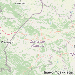
Map view of Ostoja Góry Słonne

Use this park location map to pinpoint Ostoja Góry Słonne in Poland, understand its exact geographic position, and read its mapped placement within the surrounding landscape more clearly.

Pigeon | © OpenStreetMap contributors

Location context for Ostoja Góry Słonne

Podkarpackie Voivodeship
Recorded earthquake history

Explore Historical Earthquake Records Associated with Ostoja Góry Słonne

Examine the verified seismic catalogue for Ostoja Góry Słonne to understand the history of recorded events near this protected area. MoriAtlas provides these records to support geographic research and detailed environmental context for the Polish Carpathian landscape.

Ostoja Góry Słonne Earthquake History

Catalogued events

1 event

Strongest magnitude

Magnitude 3.6

Most recent event

Jun 29, 1992

This history includes earthquakes recorded inside the park or within 50 km of its borders

Park atlas

Compare surrounding regional geography and connected protected landscapes

Other Parks and Protected Areas Near Ostoja Góry Słonne in the Carpathian Region

Browse other protected areas and forested uplands located near Ostoja Góry Słonne in southeastern Poland. Comparing adjacent regional geography helps reveal wider ecological patterns across the Carpathian mountain chain.
Nature reservePodkarpackie Voivodeship
Mapped location lies within the park boundary#1 closest

West

Dyrbek Nature Reserve: Protected Carpathian Beech Forests and Słonne Mountains Geography

A mountain forest refuge in the Podkarpackie Voivodeship

Dyrbek Nature Reserve functions as a critical forest conservation area, sheltering mature beech communities within the rugged topography of the Słonne Mountains. This site offers insight into the mesic forest ecosystems of the Eastern Carpathians, serving as a haven for sensitive raptors and forest birds that rely on undisturbed canopy cover in the southeastern Polish highlands.

Area
1.301 km²
Established
1996
Relief
Mountain
Climate
Temperate
Nature reservePodkarpackie Voivodeship
Park boundaries overlap#2 closest

North

Rzeka San Nature Reserve: Mapped Geographic Overview and Protected Riverine Corridor

Protected landscape geography in Podkarpackie Voivodeship

Rzeka San is a significant river-based nature reserve that defines a crucial ecological passage through southeastern Poland. By focusing on the aquatic and riparian habitats along the San River, this protected area provides vital support for diverse freshwater species. Its strategic position within the Podkarpackie Voivodeship and its integration with larger landscape parks showcase a complex, multi-layered approach to regional environmental conservation and riverine terrain management.

Area
13.75 km²
Established
2009
Scope
Terrestrial
Water
Water-dominated
Protected areaPodkarpackie Voivodeship
0.2 km away#3 closest

West

Sanisko w Bykowcach Protected Area: Riverine and Floodplain Landscape Mapping

Ecological terrain study of the Osława and San river confluence.

Sanisko w Bykowcach encompasses a dense cluster of Annex I habitats, including old river arms, riparian forests, and fresh meadows. This site demonstrates the interplay between river dynamics and land management in the Podkarpackie region, offering a clear view of wetland ecological transitions.

Area
0.798 km²
Established
2011
Relief
Upland
Scope
Terrestrial
National parkSubcarpathian Voivodeship
1.6 km away#4 closest

South

Bieszczady National Park: A Protected Landscape of the Eastern Carpathians

Explore mapped terrain, alpine meadows, and old-growth forests.

Discover Bieszczady National Park, a significant national park located in the Subcarpathian Voivodeship of Poland, within the Eastern Carpathian mountain range. This protected area is renowned for its vast expanses of old-growth beech forests, the characteristic połoniny alpine meadows, and its status as a UNESCO World Heritage Site, underscoring its global conservation importance. The park's wild character and dramatic mountain geography make it a key destination for atlas-driven exploration of protected landscapes.

Area
292.02 km²
Established
1973
IUCN
II
Relief
Mountain
A horizontal watercolor painting depicting a soft, layered landscape of green rolling hills and mountain ridges under a bright, clear sky.
National parkPodkarpackie Voivodeship
1.6 km away#5 closest

South

Bieszczadzki Park Narodowy: Geographic Atlas of Poland's High Carpathian Grasslands and Forests

Protected mountain terrain in the Podkarpackie Voivodeship

Bieszczadzki Park Narodowy represents one of Poland's most significant protected landscapes, encompassing the unique połoniny highland plateaus and extensive tracts of old-growth forest. This detailed overview traces the park boundaries, mapping the transitions between forested valleys and the treeless summits that characterize this distinctive Carpathian region.

Area
292.02 km²
Established
1973
Visitors
388K annual
Relief
Mountain
Protected landscapePodkarpackie Voivodeship
11 km away#6 closest

Southwest

Ciśniańsko-Wetliński Park Krajobrazowy: Geography and Protected Area Landscape Context

A vital Carpathian conservation corridor in Podkarpackie Voivodeship.

Spanning heavily forested peaks and deeply incised river gorges, Ciśniańsko-Wetliński Park Krajobrazowy functions as a core refuge for large carnivores and rare yew populations. Its distinct flysch geology and altitudinal vegetation sequences establish it as an essential component of the international Eastern Carpathians ecological network.

Area
514.61 km²
Established
1992
Relief
Mountain
Climate
Temperate
Protected areaPodkarpackie Voivodeship
12 km away#7 closest

West

Patria nad Odrzechową: A Detailed Geographic Study of Protected Polish Carpathian Forest Lands

Deciduous forest mosaic in the Bukowskie Foothills

Patria nad Odrzechową is a key protected area in Poland, renowned for its concentration of European-priority beech and oak-hornbeam forests. The site provides a compact, representative look at the transitional forest ecology of the Subcarpathian region, preserved within the larger Beskid Niski landscape framework. Explore the specific habitat boundaries and terrain features that define this essential woodland corridor.

Area
5.73 km²
Established
2011
Relief
Upland
Scope
Terrestrial
Nature reservePodkarpackie Voivodeship
16 km away#8 closest

Northwest

Wisłok Środkowy z Dopływami Protected Nature Reserve in the Podkarpackie Voivodeship

River corridor geography and riparian ecosystem analysis

Wisłok Środkowy z Dopływami serves as a crucial Natura 2000 site, safeguarding the middle course of the Wisłok River and the Stobnica tributary. This nature reserve provides essential habitat for various protected fish species and butterfly populations within a terrain shaped by the transition between the Jasielsko-Krośnieńska Basin and the Carpathian foothills. The area represents a significant riparian landscape, offering a window into the natural freshwater geography of southeastern Poland.

Area
10.646 km²
Established
2011
Relief
Upland
Scope
Terrestrial

Common questions about visiting, size, designation, and location context for Ostoja Góry Słonne

Ostoja Góry Słonne FAQs for park facts, access, geography, and protected area context

Find quick answers about Ostoja Góry Słonne, including protected-area facts, park geography, trail and visitor context, and how the park fits into its surrounding country and regional landscape.
MoriAtlas Explorer

Continue Your Protected Areas Search Across the Global Atlas

Deepen your exploration by continuing the structured search for national parks and protected areas worldwide. Utilize the comprehensive filtering capabilities to compare different conservation landscapes and refine your understanding of global park geography. Discover more about the distribution and characteristics of protected natural areas.

Global natural geography
