Mori Atlas logo
Protected areaOuadi Qadisha

Trace the mapped boundaries and regional terrain of this significant protected landscape.

Ouadi Qadisha Protected Area: Geographic Identity and Landscape Context in Lebanon

(Kadisha Valley)

Ouadi Qadisha represents a distinct protected area within Lebanon, offering users a point of entry for exploring its specific geographic identity. This page details the park's protected landscape context, helping you understand its mapped boundaries and its place within the broader natural geography of the Levant region. Engage with structured data that highlights the unique terrain and regional setting of Ouadi Qadisha for detailed atlas exploration.

UNESCO World Heritage SiteChristian MonasticismHistoric ValleyAncient CavesLebanese MountainsReligious Heritage

Ouadi Qadisha

Protected area

Park overview

Structured park overview, official facts, and landscape profile for Ouadi Qadisha

Ouadi Qadisha park facts, protected area profile, and essential visitor context

Review the core facts for Ouadi Qadisha, including designation, size, terrain, visitor scale, habitats, and operating context in one park-focused overview.

About Ouadi Qadisha

Ouadi Qadisha represents one of the most remarkable religious landscapes in the Middle East, where natural topography and human spiritual endeavor have created an inseparable cultural environment spanning more than two millennia. The valley's steep limestone cliffs and abundant caves provided ideal conditions for monastic life, offering isolation, contemplation, and protection from the outside world. Monks and hermits adapted caves and cliff faces into monastic cells, chapels, and entire monastery complexes, many of which remain active today. The valley supported both community-based cenobitic monasticism and individual eremitic traditions, creating a diverse spiritual landscape. Traditional villages including Bsharri, Ehden, Hawqa, and many others dot the valley floor and surrounding hills, their terraced fields and stone structures reflecting centuries of continuous human presence. The valley's cultural significance extends beyond its religious buildings to encompass the entire landscape of caves, terraces, water channels, and walking paths that connect monastic sites. Modern challenges include encroaching human settlement, illegal construction, and conservation concerns that have drawn warnings from UNESCO about potential future placement on the endangered list.

Quick facts and research context for Ouadi Qadisha

Ouadi Qadisha is a UNESCO World Heritage Site located in northern Lebanon, approximately 35 kilometers in length from its source in a cave below the Cedars of God forest to its confluence with the Nahr Abu Ali near Tripoli. The valley features steep cliffs with numerous caves at elevations exceeding 1,000 meters, many difficult of access. The most scenic section stretches roughly 20 kilometers between Bsharri, the hometown of poet Kahlil Gibran, and Tourza. The valley has been continuously inhabited by monastic communities since the early days of Christianity and contains multiple historic monasteries including Qannubin, Qozhaya, and Mar Sarkis. The surrounding region includes numerous traditional villages and is part of Lebanon's mountainous northern landscape.

Protection and recognition

Documenting the mixed protection scope and historical designation records of the valley

Ouadi Qadisha Protected Area Designation and Environmental Protection Status

Designated in 1998, the Ouadi Qadisha reserve features a mixed protection scope safeguarding both cultural and natural geographic dimensions. Comprehensive verification of historical designation parameters assists researchers in analyzing regional conservation boundaries and local environmental management records.

Protection details

Protection scope
Mixed
Designated year
1998
Transboundary protection
No
Park context

Deeper park guide and search-rich context for Ouadi Qadisha

Ouadi Qadisha history, landscape, wildlife, and travel context

Explore Ouadi Qadisha through its history, landscape character, ecosystems, wildlife, conservation priorities, cultural context, and seasonal travel timing in a structured park guide built for atlas discovery and search intent.

Why Ouadi Qadisha stands out

Ouadi Qadisha is best known as the 'Holy Valley,' one of the oldest and most significant centers of Christian monasticism in the Middle East. The valley is famous for its network of cave monasteries, cliff-side chapels, and terraced agricultural fields created by hermits over centuries. It is particularly renowned for the Qannubin Monastery, which served as the seat of the Maronite Patriarch for 500 years beginning in the 15th century, and the Monastery of Qozhaya, which housed the first printing press in the Middle East in 1610. The valley's association with the nearby ancient Cedars of God forest adds to its exceptional historical and religious significance.

Ouadi Qadisha history and protected-area timeline

The history of Ouadi Qadisha stretches back to the Palaeolithic period, when the valley's natural caves served as shelters and burial sites. Archaeological evidence from the Aassi Hauqqa cave near Hawqa indicates continuous use through Palaeolithic, Roman, and medieval periods. From the early days of Christianity, the valley attracted those seeking solitude and spiritual retreat, with Maronite monks establishing their center at Qannubin in the heart of the valley. The monastic communities faced significant challenges, including Mameluk campaigns in 1268 and 1283 led by Baibars and Qalaoun against the fortress-caves and monasteries. Despite these attacks, Qannubin became the seat of the Maronite Patriarch in the 15th century and retained this role for 500 years. The 17th century saw increased European interest in the valley, facilitated by the Maronite school's reputation and the 1584 founding of a Maronite college in Rome. The first printing press in the Middle East was established in 1585 at the Monastery of Qozhaya, producing its first book, the Book of Psalms in Syriac, in 1610. In 1998, the valley was inscribed as a UNESCO World Heritage Site in recognition of its extraordinary monastic heritage.

Ouadi Qadisha landscape and geographic character

Ouadi Qadisha is a dramatic limestone gorge carved by the Kadisha River, also known as Nahr Abu Ali downstream. The valley extends approximately 35 kilometers from its source in a cave below the Forest of the Cedars of God to its confluence near Tripoli. The valley sides consist of steep, often vertical cliffs containing numerous caves at elevations exceeding 1,000 meters, many extremely difficult to access. The most scenically impressive section spans roughly 20 kilometers between the town of Bsharri and Tourza, characterized by dramatic cliff faces, cascading streams, and lush vegetation in the valley floor. The surrounding landscape includes the ancient Cedars of God forest on the mountain above the valley, preserving living specimens of the legendary Cedrus libani. The terrain creates numerous microclimates and ecological niches, with the river providing water for terraced agriculture throughout the valley. The overall impression is of a deep, dramatic fissure in the mountainside, with human settlement and monastic structures nestled against the cliff walls and on ledges throughout the gorge.

Ouadi Qadisha ecosystems, habitats, and plant life

The ecological character of Ouadi Qadisha encompasses a transition from montane cedar forest at higher elevations through mixed deciduous woodland to the cultivated valley floor. The valley's limestone geology creates numerous caves and karst features that support specialized ecosystems. The Kadisha River and its tributaries provide aquatic habitats and water for agriculture throughout the valley. The nearby Forest of the Cedars of God, while a separate protected area, forms an integral part of the broader landscape context, preserving ancient Cedrus libani specimens including trees claimed to be over 3,000 years old. The valley's steep slopes and varied aspect create diverse microhabitats supporting Mediterranean vegetation communities, while the canyon walls provide nesting sites for birds of prey. The combination of protected forest above and the gorge's unique microclimate contributes to biodiversity in this mountainous region of Lebanon.

Ouadi Qadisha wildlife and species highlights

While detailed wildlife documentation is limited in the source material, Ouadi Qadisha's diverse habitats support various bird species associated with cliff faces and forested slopes. The valley's limestone walls provide nesting sites for raptors, while the river corridor and surrounding vegetation support other birdlife. The broader northern Lebanon mountains region is known for migratory bird routes and species diversity. The cave systems throughout the valley may contain specialized troglobitic species adapted to underground environments. The presence of the nearby Cedars of God forest indicates a broader ecological zone supporting species associated with old-growth forest and montane ecosystems.

Ouadi Qadisha conservation status and protection priorities

Ouadi Qadisha was inscribed as a UNESCO World Heritage Site in 1998 under cultural criteria (iii) and (iv), recognizing its importance as the site of some of the earliest Christian monastic settlements and its continued example of living Christian faith. However, the valley faces significant conservation challenges including encroachment from human settlement, illegal building construction, and inconsistent conservation activity. While not currently on UNESCO's endangered list, warnings have been issued that continued violations may lead to this status. The protection framework addresses both the remarkable archaeological and architectural heritage of the monasteries and cave dwellings, as well as the broader cultural landscape that includes traditional agricultural terraces and villages. Conservation efforts must balance the needs of living monastic communities and local residents with the preservation of historic structures and natural landscape values.

Ouadi Qadisha cultural meaning and human context

Ouadi Qadisha represents an exceptional example of the relationship between landscape and religious practice in the Middle East. The valley has been a continuous center of Christian monasticism since the early centuries of the faith, with the Maronite tradition particularly associated with the region. The caves and cliff faces were not merely shelters but were actively adapted into monastic architecture, with cells, chapels, and churches carved from rock or built against cliff walls. The valley supported both communal monastic life and individual hermit traditions, creating a distinctive religious culture. The presence of the first Middle Eastern printing press at Qozhaya in the early 17th century demonstrates the valley's historical role as a center of learning and cultural production. The valley remains home to active monastic communities, making it a living cultural landscape rather than a purely archaeological site. The traditional villages and agricultural terraces throughout the valley reflect centuries of human interaction with this challenging landscape.

Top sights and standout views in Ouadi Qadisha

The network of ancient cave monasteries representing one of Christianity's oldest monastic traditions; the Qannubin Monastery, seat of the Maronite Patriarch for 500 years; the Monastery of Qozhaya housing the first printing press in the Middle East; steep cliffs containing caves at elevations exceeding 1,000 meters; proximity to the Forest of the Cedars of God with trees claimed to be over 3,000 years old; the dramatic 20-kilometer scenic section between Bsharri and Tourza; UNESCO World Heritage status since 1998; the discovery of well-preserved Maronite mummies dating to around 1283 AD in the valley's caves.

Best time to visit Ouadi Qadisha

The valley can be visited throughout the year, though spring and early summer offer pleasant temperatures for hiking between monasteries and exploring the gorge. The winter months may bring snow in higher elevations and cooler conditions in the valley, while summer can be hot in the lower valley floor. The valley's monastic communities remain active year-round, so visitors interested in experiencing the living religious culture should be respectful of prayer times and monastic schedules. The dramatic landscape is particularly impressive after rainfall when streams cascade down the cliff faces, though some trails may be more challenging. Visitors interested in the historical and religious sites should allow sufficient time to explore the various monasteries and caves, many of which require moderate hiking to access.
Monthly climate preview

Track multi-year average temperature and precipitation patterns across the landscape.

Ouadi Qadisha Climate Normals and Long-Term Monthly Weather Rhythms

Historical monitoring data from 1991 through 2020 establishes a structured baseline of average temperature and precipitation metrics for Ouadi Qadisha. Examining the complete twelve-month record clarifies long-term meteorological variations at the designated reference coordinate.
Annual mean16 °C
6 °C25 °C
Jan
Feb
Mar10°
Apr14°
May18°
Jun22°
Jul25°
Aug25°
Sep22°
Oct18°
Nov12°
Dec
Warmest month
July

24.8 °C

Coolest month
January

6.1 °C

Wettest month
January

2.6 mm/day

Driest month
July

0 mm/day

Park location guide

Geography guide, regional context, and park location map for Ouadi Qadisha

Ouadi Qadisha park geography, regions, and map view in Lebanon

Understand where Ouadi Qadisha sits in Lebanon through a broader geographic reading of the surrounding landscape, nearby location context, and its mapped position within the national park landscape.

How Ouadi Qadisha fits into Lebanon

Lebanon is a unitary parliamentary republic under confessionalism with a population of over 5 million. Located on the Mediterranean coast at the crossroads of ancient trade routes, it has a diverse religious composition with Islam and Christianity as the main faiths. The country has historical roots dating to Phoenicia and has been ruled by Romans, Byzantines, Ottoman Empire, and France.

Wider geography shaping Ouadi Qadisha in Lebanon

Lebanon is located in the Levant region of West Asia on the eastern Mediterranean coast. It is bordered by Syria to the north and east, Israel to the south, and the Mediterranean Sea to the west. The country has a small territory of 10,452 square kilometres, with a narrow coastal plain and mountainous interior including the Lebanon Mountains.

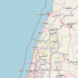
Map view of Ouadi Qadisha

Use this park location map to pinpoint Ouadi Qadisha in Lebanon, understand its exact geographic position, and read its mapped placement within the surrounding landscape more clearly.

Pigeon | © OpenStreetMap contributors
Park atlas

From Ouadi Qadisha's ancient monastic sites, explore other protected areas and national parks across Lebanon's unique mountain geography.

Discover Nearby National Parks and Protected Areas around Ouadi Qadisha

Explore a curated list of national parks and protected areas located near Ouadi Qadisha, the historic Holy Valley in Lebanon. This allows you to trace the regional spread of conservation efforts, compare diverse landscapes, and understand broader geographic connections across Lebanon's mountainous terrain and beyond.
Nature reserveLebanon
About 7.2 km away#1 closest

Northeast

Horsh Ehden Nature Reserve: Protected Nature Reserve within Lebanon's Regional Geography

Explore mapped protected land and natural terrain.

Horsh Ehden Nature Reserve is identified as a critical protected area within Lebanon. This page facilitates an atlas-style exploration of the reserve's specific geographic footprint, highlighting its mapped boundaries and the distinct natural terrain it preserves. Understanding Horsh Ehden Nature Reserve's role as a nature reserve contributes to a broader appreciation of protected landscapes and their regional context.

Area
17.4 km²
Established
1992
IUCN
Ib
Relief
Mountain
Nature reserveNorth Lebanon Governorate
About 8.6 km away#2 closest

Southwest

Tannourine Cedar Forest Nature Reserve: A Premier Protected Cedar Landscape in North Lebanon

Mapped geography of Lebanon's largest cedar forest.

Delve into the Tannourine Cedar Forest Nature Reserve, a protected area critically important for its extensive cedar groves within the North Lebanon Governorate. This nature reserve encompasses a complex mountain geography characterized by deep ravines, imposing cliffs, and secluded caves, providing a dramatic backdrop for its dominant cedar population. Users can explore the mapped boundaries and understand the regional landscape context of this ecologically significant coniferous forest, essential for Lebanon's natural atlas.

Area
1.955 km²
Established
1999
IUCN
IV
Relief
Mountain
Nature reserveBaalbek-Hermel Governorate
About 14 km away#3 closest

Southeast

Yammoune Nature Reserve: Mapped Geography and Protected Area Context in Lebanon

High altitude mountain lake and juniper forest landscapes

Yammoune Nature Reserve offers a comprehensive look at the high northern Beqaa Valley through its rare juniper-covered uplands and unique freshwater ecosystem. The reserve hosts the only habitat for Lebanon's endemic fish, set against a backdrop of ancient Roman ruins and active geological fault lines that define the regional mountain terrain.

Established
1998
Relief
Upland
Climate
Mediterranean
Access
Access unknown
Protected areaLebanon
About 25 km away#4 closest

West

Ras ash-Shaq'a: Protected Area, Coastal Cliffs, and Geography of Northern Lebanon

A prominent Mediterranean headland and wetland refuge in Lebanese coastal terrain.

Ras ash-Shaq'a stands as a massive cliff-bound promontory on the coast of Lebanon. This protected area offers a look at the interplay between limestone formations and the Mediterranean Sea, housing critical wetland habitats and historic pilgrimage sites that have shaped regional land use for centuries.

Established
1999
Climate
Mediterranean
Scope
Terrestrial
Water
Major water bodies
Nature reserveKeserwan District
About 27 km away#5 closest

Southwest

Jabal Moussa Biosphere Reserve: Lebanon's Protected Nature Reserve with Distinct Geographic Identity

Mapped protected landscape within Keserwan District's regional geography.

Jabal Moussa Biosphere Reserve represents a crucial protected area in Lebanon, defined by its unique natural landscape and mapped boundaries. Positioned within the Keserwan District, this nature reserve offers valuable insights for geographic exploration and understanding protected land distribution. Its inclusion in the MoriAtlas platform highlights its significance for regional conservation and atlas-style discovery of Lebanon's natural terrain.

Area
65 km²
Established
2009
Relief
Mountain
Climate
Mediterranean
Nature reserveLebanon
About 31 km away#6 closest

Northwest

Palm Islands Nature Reserve: A Protected Lebanese Nature Reserve with Critical Marine Habitats

Discover the island geography and mapped protected area.

Palm Islands Nature Reserve encompasses three flat, rocky limestone islands off the coast of northern Lebanon. This vital nature reserve, recognized internationally as a Ramsar site and Mediterranean Specially Protected Area, serves as a critical habitat for endangered green sea turtles and Mediterranean monk seals. Its unique coastal landscape and surrounding waters offer essential resting grounds for migratory birds, making it a significant point in the regional atlas of protected lands.

Area
4.2 km²
Established
1992
Relief
Lowland
Climate
Mediterranean
Biosphere reserveLebanon
About 59 km away#7 closest

South

Aammiq Wetland Biosphere Reserve: Mapping Lebanon's Crucial Freshwater Protected Landscape

Discover its geography, mapped terrain, and role as a biodiversity hotspot.

Aammiq Wetland is Lebanon's most significant freshwater protected area, recognized as a UNESCO Biosphere Reserve and Ramsar site. Its unique geography, characterized by extensive reedbeds and open pools fed by mountain snowmelt, makes it a vital stopover for countless migratory bird species traversing the Middle East. This protected landscape offers rich opportunities for atlas-style exploration, revealing the ecological importance of its mapped terrain and its role as a critical biodiversity hotspot.

Area
2.53 km²
Established
1999
IUCN
IV
Relief
Lowland
Nature reserveLebanon
About 66 km away#8 closest

South

Al Shouf Cedar Nature Reserve: A Protected Landscape in Lebanon's Geography

Explore its mapped natural terrain and protected boundaries.

Investigate Al Shouf Cedar Nature Reserve, a protected natural area situated within Lebanon. This page offers a detailed view of its protected landscape identity and geographic context, crucial for understanding its placement within the region's natural atlas. Examine the mapped terrain and park boundaries that distinguish this significant nature reserve.

Area
550 km²
Established
1996
Relief
Mountain
Climate
Temperate

Common questions about visiting, size, designation, and location context for Ouadi Qadisha

Ouadi Qadisha FAQs for park facts, access, geography, and protected area context

Find quick answers about Ouadi Qadisha, including protected-area facts, park geography, trail and visitor context, and how the park fits into its surrounding country and regional landscape.
MoriAtlas Explorer

Continue Your Protected Areas Search Across the Global Atlas

Deepen your exploration by continuing the structured search for national parks and protected areas worldwide. Utilize the comprehensive filtering capabilities to compare different conservation landscapes and refine your understanding of global park geography. Discover more about the distribution and characteristics of protected natural areas.

Global natural geography