
Lakes
Park geography
A comprehensive analysis of landscape boundaries, coastal terrain, and regional geography
Structured Geographic Profile of Pacific Rim National Park Reserve in British Columbia, Canada
Examine the detailed geographic characteristics of Pacific Rim National Park Reserve, a coastal and marine landscape spanning 511 square kilometers within British Columbia. This structured profile delineates the park's administrative context, complex perimeter, and varied terrain, which encompasses mountains, coniferous forests, wetlands, and extensive coastal features.
Related tags
Temperate RainforestCoastal IslandsMarine Protected AreaWest Coast TrailSea Kayaking
Coastal temperate rainforest and Pacific shoreline on Vancouver Island
Pacific Rim National Park Reserve
Pacific Rim National Park Reserve is a 511 square kilometre protected area located on the west coast of Vancouver Island in British Columbia, Canada. The park comprises three distinct units that showcase the rugged beauty of Canada's Pacific shoreline: the Long Beach area with its sweeping sand beaches and old-growth rainforest, the Broken Group Islands scattered throughout Barkley Sound, and the famed West Coast Trail. This national park reserve protects a remarkable diversity of ecosystems including temperate rainforest, coastal dunes, rocky shores, and marine environments. The region experiences one of the wettest climates in Canada, receiving over 3,500 millimetres of precipitation annually, which sustains the lush vegetation that characterizes the landscape. Pacific Rim represents the Pacific Coast Mountains natural region in the Parks Canada system and serves as one of three national parks with direct ocean access on Canada's west coast.
- Location
- Canada
- Park type
- National park
- Established
- 1970
- Area
- 511 km²
Location overview
A coastal, island, and marine protected area in British Columbia
Geography and Location of Pacific Rim National Park Reserve
Pacific Rim National Park Reserve is located on Vancouver Island within British Columbia, Canada. Certified records define the area as a coastal, island, and marine park without transboundary reach.
- Countries
- Canada
- Regions
- British Columbia, Vancouver Island
- Primary location
- British Columbia
- Geographic setting
- Coastal · Island · Marine
Boundary and coordinates
Interactive boundary geometry and derived spatial measurements
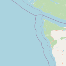
Pacific Rim National Park Reserve Boundary Map and Spatial Extent
Mapped park outlines provide visual spatial context for the protected terrain. Accompanying records detail calculated land and marine areas, coordinate limits, and geographic spans without legal survey claims.
- Boundary area
- 516.8 km²
- Boundary perimeter
- 420.2 km
- Northernmost point
- 49.123° N
- Southernmost point
- 48.5391° N
- Easternmost point
- 124.387° W
- Westernmost point
- 125.9078° W
- Geographic centre
- 48.8361° N, 125.1931° W
- North–south span
- 64.9 km
- East–west span
- 111.7 km
Elevation and terrain
Mountain relief metrics and recorded coastal and inland natural features
Pacific Rim National Park Reserve Terrain and Elevation Profile
Recorded elevation data outlines the mountain relief summary for this protected area. Linked feature cards document specific lakes, beaches, streams, and islands located within the boundaries.
- Minimum elevation
- 0 m
Selected named natural features
Beaches
Long Beach
Islands
Mence Island
Streams
150 Yard Creek
Streams
Orange Juice Creek
Beaches
South Beach
Environmental setting
Temperate mountain relief, dominant forest cover, and coastal water systems
Pacific Rim National Park Reserve Environmental Classifications and Setting
Recorded landscape features, habitat types, and seasonal classifications organize the physical setting of Pacific Rim National Park Reserve into broad interpretive categories. Stored environmental attributes link directly to related atlas destinations for structured geographic comparison.
- Relief
- Mountain
- Climate
- Temperate
- Water
- Water-dominated
- Forest cover
- Dense forest cover
- Seasonality
- Strongly seasonal
Landscape features
Mountains · Cliffs · Forest · Wetland · Lakes · Rivers · Waterfalls · Coast · Beach · Dunes · Islands · Reefs
Habitat types
Temperate coniferous forest · Wetland · Riverine habitat · Lacustrine habitat · Coastal habitat · Marine habitat · Dune habitat
Park atlas
Compare coastal protected landscapes, temperate rainforests, and marine environments across Vancouver Island.
Explore National Parks and Protected Areas Near Pacific Rim National Park Reserve
After exploring Pacific Rim National Park Reserve, continue your geographic discovery of Canada's west coast protected areas. Browse adjacent national parks and other significant conservation landscapes to trace their regional context, shared ecosystems, and unique characteristics on a broader scale.
Marine protected areaWashington
9.6 km away#1 closest
South

Olympic Coast National Marine Sanctuary: Mapping the Washington Outer Coast Marine Protected Area
Pacific Ocean canyons, shelf ecosystems, and coastal wilderness
Defined by its proximity to the Olympic Peninsula, this marine protected area spans a rugged stretch of the Pacific Ocean. The sanctuary encompasses significant seafloor features including the Nitinat and Quinault canyons, alongside dynamic upwelling zones that support diverse marine life and complex tidal habitats.
- Area
- 8,260 km²
- Established
- 1994
- IUCN
- IV
- Climate
- Temperate
Protected areaBritish Columbia
24 km away#2 closest
Northwest

Č̓icy̓i Conservancy: Protected Coastal Rainforest and Flores Island Geography
Coastal wilderness in the Alberni-Clayoquot region
Spanning over nine thousand hectares on Flores Island, Č̓icy̓i Conservancy preserves a substantial wilderness area characterized by dense coastal temperate rainforests, rocky headlands, and expansive intertidal zones. As a significant addition to the protected network of outer Vancouver Island, the area integrates diverse Pacific marine and forest ecosystems. The geography highlights the cultural and ecological continuity of the coastline.
- Area
- 92.69 km²
- Established
- 2024
- Access
- Access unknown
- Scope
- Terrestrial
National parkWashington
32 km away#3 closest
Southeast
Olympic National Park National Park: Geographic Atlas and Protected Landscape Discovery
Explore its unique Washington landscape and mapped protected areas.
Olympic National Park serves as a key protected area within Washington, offering rich opportunities for geographic exploration. This detail page provides essential context on its designation as a national park, its mapped boundaries, and its contribution to the regional geography. Understand the park's specific landscape character and its role within the atlas of protected lands, facilitating a structured approach to discovering its natural terrain and geographic significance.
- Area
- 3,733.8 km²
- Established
- 1938
- IUCN
- II
- Visitors
- 3.7M annual
Protected areaBritish Columbia
38 km away#4 closest
Northwest
Kiišḥniqʷus Conservancy: Coastal Wilderness and River Valley Geography in British Columbia
Protected coastal inlet and temperate rainforest terrain
Kiišḥniqʷus Conservancy protects a significant expanse of land between Sydney Inlet and Shelter Inlet on the outer coast of Vancouver Island. This area focuses on the Sydney River valley and the associated estuarine environments, forming a vital part of the regional wilderness corridor. The geography showcases the intersection of deep coastal fjords, dense coniferous forest, and historic cultural sites, providing an essential look at the natural and indigenous history of the region.
- Area
- 110.12 km²
- Established
- 2024
- Scope
- Terrestrial
- Water
- Major water bodies
Protected areaBritish Columbia
43 km away#5 closest
Northwest
Kʷuḥaa Conservancy: A Coastal Protected Area on Western Vancouver Island
Temperate rainforest, marine inlets, and cultural geography.
Kʷuḥaa Conservancy covers a rugged, forested stretch of the British Columbia coastline, focusing on the preservation of the Stewardson Inlet head. The area integrates coastal slopes with sheltered marine environments, providing a crucial addition to the regional network of protected lands. Explore the site's unique topographical features and its cultural significance within the Nuu-chah-nulth territory near Tofino.
- Area
- 19.16 km²
- Established
- 2024
- Relief
- Lowland
- Climate
- Temperate
Protected landscapeWashington
43 km away#6 closest
Southeast
Olympic National Forest: Atlas and Geographic Overview of Washington Protected Lands
Temperate rainforests, alpine ridges, and fjord shorelines
Olympic National Forest defines the outer reaches of the Olympic Mountains, featuring a massive expanse of old-growth conifers and high-precipitation temperate rainforests. This protected area connects diverse ecosystems ranging from the brackish waters of Hood Canal to rugged, snow-dusted subalpine ridges. Our detailed geographic mapping highlights the forest's role as a vital buffer and wilderness corridor within the broader Pacific Northwest landscape.
- Area
- 2,541.89 km²
- Established
- 1897
- Relief
- Mountain
- Climate
- Temperate

State or regional parkBritish Columbia
54 km away#7 closest
North
Little Qualicum Falls Provincial Park: Regional Protected Landscape and Atlas Geography
River canyon and mountain lake habitat in British Columbia
Explore the structured geography of Little Qualicum Falls Provincial Park, a protected area characterized by its sequence of dramatic river cascades and old-growth Douglas Fir stands. This entry maps the park's key natural features, including the Cameron Lake shoreline and the rugged canyon terrain of the Little Qualicum River.
- Area
- 4.4 km²
- Established
- 1940
- IUCN
- II
- Relief
- Mountain

State or regional parkBritish Columbia
About 55 km away#8 closest
North
MacMillan Provincial Park: Mapped Geography and Protected Forest Landscapes
Vancouver Island, British Columbia
Examine the mapped footprint of MacMillan Provincial Park, home to iconic old-growth Douglas fir trees and the Cameron River delta. This protected area serves as a biogeoclimatic transition zone, showcasing the rich, moisture-retentive coastal forest environment that defines this specific section of Vancouver Island.
- Area
- 3.01 km²
- Established
- 1947
- IUCN
- III
- Visitors
- 543.7K annual
MoriAtlas Explorer
Continue exploring the geography of Pacific Rim National Park Reserve and British Columbia
Deepen your understanding of Pacific Rim National Park Reserve by examining its specific geographic features and mapped protected area boundaries. This exploration extends to its regional context within British Columbia, offering a comprehensive view of Canada's conservation landscapes and their intricate placement in the global atlas.
Browse next
Global natural geography
Explore related park routes
Explore MoriAtlas Global ParksBrowse All MoriAtlas ParksGlobal Park Map DiscoveryMoriAtlas: Browse All CountriesBrowse All MoriAtlas ContinentsNational Park Environment AtlasGrand Canyon National Park AtlasYellowstone National Park AtlasYosemite National Park Atlas and GeographySerengeti National Park AtlasGalápagos National Park Protected LandscapeBanff National Park Geography and AtlasKruger National Park Atlas EntryUluṟu-Kata Tjuṯa National Park AtlasExplore Uluru-Kata Tjuta National Park GeographyPlitvice Lakes National Park AtlasFiordland National Park Protected LandscapeGreat Smoky Mountains National Park AtlasAfghanistan National Parks and Protected AreasAlbania National Parks and Protected AreasAlgeria National Parks and Protected AreasAmerican Samoa National Parks and Protected AreasAndorra National Parks and Protected AreasAngola National Parks and Protected AreasAntarctica National Parks and Protected AreasAntigua and Barbuda Park List