Mori Atlas logo
Wildlife reserveRed Buttes Wilderness

Explore the ancient metamorphic ridges and diverse botanical terrain spanning the California and Oregon border.

Red Buttes Wilderness: Mapping the Protected Landscapes and Geographic Identity of the Siskiyou Crest

Red Buttes Wilderness protects a geologically ancient stretch of the Siskiyou Mountains, characterized by iron-rich peaks, deep forested canyons, and high subalpine basins. This protected area serves as a vital geographic anchor within the Klamath Mountains Province, featuring unique serpentine plant communities and rare forest ecosystems. Visitors can trace the complex ridge-and-gully terrain across the crest that separates the Klamath and Rogue River drainages, revealing a landscape defined by its distinctive reddish-orange metamorphic rock formations.

wilderness areaKlamath MountainsSiskiyou Mountainsold-growth forestBrewer spruceserpentinite outcrops

Red Buttes Wilderness

Wildlife reserve

Park overview

Structured park overview, official facts, and landscape profile for Red Buttes Wilderness

Red Buttes Wilderness park facts, protected area profile, and essential visitor context

Review the core facts for Red Buttes Wilderness, including designation, size, terrain, visitor scale, habitats, and operating context in one park-focused overview.

About Red Buttes Wilderness

Red Buttes Wilderness is a congressionally designated wilderness area spanning the crest of the Siskiyou Mountains between southwestern Oregon and northwestern California. Although it covers nearly 20,000 acres in total, it feels like a compact, deeply forested high-country enclave, roughly 13 miles long and 6 miles wide, tucked between major river drainages.

The landscape is defined by steep canyons, broad forested ridges, and sharply rising summits at the very spine of the Klamath Mountains Province. Elevations climb from about 2,800 feet in Butte Fork Canyon to nearly 6,740 feet at the east summit of the Red Buttes, producing a vertical range big enough to support a succession of plant communities from low-elevation pine and Douglas-fir forests up to mountain hemlock and subalpine fir stands near the highest ridges.

Beyond its scenery, Red Buttes is valued as a refuge for old-growth forests and endemic plant communities, and as a connecting high-country corridor between the Rogue and Klamath river systems. Designated wilderness in 1984 and managed under the standards of the Wilderness Act of 1964, it remains a relatively quiet, lightly visited preserve in which natural processes are allowed to dominate over development and infrastructure.

Quick facts and research context for Red Buttes Wilderness

Red Buttes Wilderness is composed of nearly 20,000 acres of mountainous terrain within the Klamath and Rogue River–Siskiyou national forests. The bulk of the area lies in Siskiyou County, California, with a smaller portion extending into Josephine County, Oregon, straddling the state line along the Siskiyou Crest.

The protection status is IUCN category Ib, reflecting its designation as a congressionally protected wilderness administered by the U.S. Forest Service. The wilderness was established in 1984 and contains the headwaters of the Illinois River as well as major forks of the Applegate and Rogue River systems, tying it directly to the broader Klamath–Rogue watershed.

Protection and recognition

Documented terrestrial protection scope and international designation records

Red Buttes Wilderness Protection Status and Transboundary Area Overview

Red Buttes Wilderness maintains a documented terrestrial protection scope across shared regional boundaries without active international recognition sources. Structured records outline baseline conservation assignments and protected area management parameters for this designated landscape.

Protection details

Protection scope
Terrestrial
Transboundary protection
Yes
Park context

Deeper park guide and search-rich context for Red Buttes Wilderness

Red Buttes Wilderness history, landscape, wildlife, and travel context

Explore Red Buttes Wilderness through its history, landscape character, ecosystems, wildlife, conservation priorities, cultural context, and seasonal travel timing in a structured park guide built for atlas discovery and search intent.

Why Red Buttes Wilderness stands out

Red Buttes Wilderness is best known for occupying a remote and geologically ancient stretch of the Siskiyou Mountains, a range often described as among the oldest in the Pacific Northwest. The complex metamorphic rocks exposed here, including schist, quartzite, gneiss, and white marble, give the landscape much of its character. The wilderness is also recognized for its concentration of rare and endemic plant communities, particularly the unusual vegetation that grows on peridotite and serpentinite outcrops. These mineral-rich substrates support stands of Jeffrey pine, western white pine, and the regionally iconic Brewer spruce, alongside a range of species found nowhere else but the overlapping corner of southwestern Oregon and northwestern California.
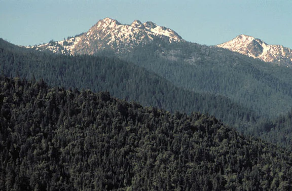
A wide view of jagged mountain peaks with patches of snow, surrounded by extensive evergreen coniferous forests in the Red Buttes Wilderness.
The distinctive peaks of the Red Buttes in the Siskiyou Crest, rising above dense evergreen forests.

Red Buttes Wilderness history and protected-area timeline

Human history along the Siskiyou Crest reaches back thousands of years. Native American groups are believed to have traveled and hunted in what is now the Red Buttes Wilderness for perhaps 8,000 years. In late prehistoric times the Dakubetede Indians of the Applegate Valley are thought to have used the area regularly, sharing it on occasion with neighboring peoples such as the Shasta, the Karuk, and the Takelma. They hunted deer, bighorn sheep, elk, and grizzly bear, and arrowheads, scrapers, and other stone tools from several millennia of use have been recovered within the wilderness.

The first Euro-American arrivals most likely came during the Siskiyou gold rush of the early 1850s. Prospecting, mining on a small scale, trapping, hunting, and livestock grazing brought locals into the mountains throughout the late 19th and early 20th centuries, leaving a faint imprint of human activity on an otherwise remote landscape. In the 1920s and 1930s the U.S. Forest Service built trails and a few cabins in the area to support administrative and recreational use.

During World War II the U.S. government pushed a narrow mining road from the Klamath River up to chromite deposits on the south slope of the Red Buttes, a relic of wartime mineral demand. In 1945 a single-engine airplane crashed in the wilderness, and a bronze plaque along the Butte Fork Trail commemorates three of the victims buried nearby. In 1984, Red Buttes was formally designated Wilderness through the California Wilderness Act of 1984 and the Oregon Wilderness Act of 1984, securing the protections of the Wilderness Act of 1964 for the area.

Red Buttes Wilderness landscape and geographic character

Red Buttes Wilderness is shaped by the Siskiyou Mountains, part of the broader Klamath Mountains Province that links southwestern Oregon and northwestern California. The terrain spans steep, forested canyons and high, often rocky ridges, and the wilderness includes the crest of the range itself, giving it a strongly mountainous, ridge-and-gully character.

The lowest point lies along Butte Fork Canyon near 2,800 feet, while summits along the crest rise to roughly 6,740 feet. This elevation gradient compresses a remarkable variety of terrain into a relatively small area: canyon-bottom streams, mid-slope forest benches, exposed ridgelines, and high subalpine basins. Small lakes and meadows sit in glacial basins at the higher elevations, the legacy of small ice age glaciers that once sculpted the Siskiyou basins.

The rocks beneath this landscape are among the oldest in the region. Sediments originally laid down on an ancient ocean floor were transformed over hundreds of millions of years into schist, quartzite, gneiss, and isolated outcrops of white marble. The distinctive reddish-orange color of the butte rock that gives the wilderness its name reflects elevated iron and magnesium content in these metamorphic formations, lending the crest a visual identity that remains striking seen from a distance.

Red Buttes Wilderness ecosystems, habitats, and plant life

Ecologically, Red Buttes sits at a transition zone where several distinct botanical worlds converge. At the lowest elevations, an old-growth mosaic of ponderosa pine, sugar pine, Douglas-fir, and incense-cedar forms a multilayered canopy, with an understory of Pacific madrone, canyon live oak, and chinquapin. Higher on the slopes, the forest composition shifts, giving way to mixed stands of white fir, Shasta red fir, and mountain hemlock, with knobcone pine common on drier, rocky ridges.

Perhaps the most distinctive ecological feature of the wilderness is its vegetation on peridotite and serpentinite outcrops, mineral-rich substrates that host a specialized community of Jeffrey pine, western white pine, and Brewer spruce. A small stand of subalpine fir has also been documented here. Species such as Brewer's spruce, Sadler oak, Siskiyou lewisia, and a suite of sclerophyllous shrubs are found almost exclusively in this overlapping region of southwestern Oregon and northwestern California, making the wilderness an important reservoir of regional botanical endemism.

The presence of lakes and wet meadows at the higher elevations adds a further layer to the ecological character, supporting moisture-loving plant communities and providing clean, quiet habitat for wildlife throughout the warmer months.

Red Buttes Wilderness wildlife and species highlights

Wildlife in Red Buttes Wilderness reflects the diversity of its elevation range and habitat types, from mixed old-growth forests to high meadows and rocky ridgelines. Black-tailed deer are among the most frequently encountered mammals, while American black bears, California Valley coyotes, ring-tailed cats, bobcats, and North American cougars also roam the area in smaller numbers.

The wilderness supports a wide array of small mammals, including members of the rodent and weasel families that occupy the dense understory and rocky slopes. In the skies and forest canopy above, eagles, hawks, falcons, northern goshawks, owls, Steller's jays, and ravens represent the more conspicuous birds of the area, contributing to a rich soundscape that changes with elevation and season.

The presence of large predators, intact old-growth habitat, and long-standing reports ranging from credible wildlife observations to the more sensational unsubstantiated Bigfoot sightings over the past century underscores the wilderness's reputation for remote and relatively undisturbed wildlife habitat on the Klamath–Siskiyou high country.

Red Buttes Wilderness conservation status and protection priorities

Red Buttes Wilderness plays a meaningful conservation role in protecting one of the most botanically distinctive areas within the Klamath Mountains Province. By safeguarding old-growth conifer forests, including low-elevation stands where ponderosa pine, sugar pine, Douglas-fir, and incense-cedar form complex canopies, the wilderness preserves mature forest structure that is increasingly rare across the broader region.

Its vegetation on peridotite and serpentinite outcrops, where Jeffrey pine, western white pine, and Brewer spruce coexist alongside numerous regional endemics, gives the wilderness a particular importance for botanical conservation. Species like Sadler oak, Siskiyou lewisia, and a suite of sclerophyllous shrubs found here exist only in the narrow overlap of southwestern Oregon and northwestern California, making the area a key refuge for genetic and ecological diversity that cannot easily be replaced elsewhere.

As congressionally designated wilderness managed under the Wilderness Act of 1964, the area is conserved primarily for the protection of its ecological and geological values rather than for resource extraction or development. Its position along the Siskiyou Crest, combined with its role as a headwaters area for the Illinois River and several Applegate and Rogue River forks, gives it added significance as a watershed-protecting reserve within the larger national forest landscape.

Red Buttes Wilderness cultural meaning and human context

Red Buttes Wilderness lies within a landscape that has supported human use for thousands of years. Native American groups, including the Dakubetede of the Applegate Valley, the Shasta, the Karuk, and the Takelma, appear to have shared the high country of the Siskiyou Crest as a hunting ground for animals like deer, bighorn sheep, elk, and grizzly bear. The recovery of arrowheads, scrapers, and other stone tools within the wilderness attests to long, continuous Indigenous presence in this part of the mountains.

The mid-19th century Siskiyou gold rush drew the first non-native prospectors into the area, followed by successive waves of trappers, hunters, livestock graziers, and miners, particularly in the late 19th and early 20th centuries. The early 20th-century construction of Forest Service trails and cabins, and the World War II-era mining road along the south slope of the Red Buttes, mark further human imprints on this otherwise remote terrain. Today, the wilderness is valued as a place where earlier traces of these varied uses sit quietly alongside an exceptional natural landscape, in keeping with its wilderness character.

Top sights and standout views in Red Buttes Wilderness

The Red Buttes themselves, an iron- and magnesium-rich outcrop whose reddish color gives the wilderness its name and forms a striking visual landmark along the Siskiyou Crest, stand among the area's most recognizable features. The wilderness's position at the spine of the Siskiyou Mountains, dividing the Rogue and Klamath drainages, gives it a particular geographic prominence within the larger Klamath–Siskiyou landscape.

Trail-side gems such as Azalea Lake and small meadows and ponds scattered among the glacial basins add to the area's appeal for backcountry visitors, as does the contrast between deep, old-growth forested canyons and exposed rocky ridges above. The wilderness is also notable for the unusually rich plant communities on its peridotite and serpentinite outcrops, where Brewer spruce and several regionally endemic shrubs and wildflowers find a stronghold nowhere else.

Best time to visit Red Buttes Wilderness

Like much of the Klamath–Siskiyou high country, Red Buttes Wilderness is best appreciated in summer and early autumn, when snow has receded from the higher elevations and trails through the crest are typically accessible. Summer brings warmer temperatures, blooming high-country meadows, and the best conditions for exploring lakes such as Azalea Lake and traversing the route along the Bigfoot Trail.

Spring and fall can also be rewarding, with cooler weather and fewer visitors in the backcountry, though snow can linger into late spring at the highest elevations and may return to high basins and ridges in late autumn. Winter generally transforms the wilderness into a snow-covered, less accessible landscape, making it a quieter, more specialized season primarily oriented toward experienced backcountry travelers. Across all seasons, conditions can vary sharply between the lower forested canyons and the exposed ridgeline, and visitors benefit from planning for changing weather in this transitional mountain environment.

Monthly climate preview

Track monthly temperature variations and precipitation averages across representative terrain

Red Buttes Wilderness Climate Normals, Annual Temperature and Precipitation Profiles

Representative coordinate records show measured long-term averages for monthly temperature and precipitation rhythms across the protected landscape. Detailed multi-month climate normals provide complete statistical breakdowns for professional geographic evaluation.
Annual mean9 °C
1 °C20 °C
Jan
Feb
Mar
Apr
May10°
Jun14°
Jul20°
Aug20°
Sep16°
Oct10°
Nov
Dec
Warmest month
July

19.6 °C

Coolest month
December

1.1 °C

Wettest month
December

7 mm/day

Driest month
August

0.3 mm/day

Park location guide

Geography guide, regional context, and park location map for Red Buttes Wilderness

Red Buttes Wilderness park geography, regions, and map view in United States of America

Understand where Red Buttes Wilderness sits in United States of America through a broader geographic reading of the surrounding landscape, nearby location context, and its mapped position within the national park landscape.

How Red Buttes Wilderness fits into United States of America

The United States of America is a federal presidential republic and one of the world's largest countries by area and population. It consists of 50 states across a vast territory spanning multiple time zones, with its capital in Washington, D.C. and largest city in New York City. The nation has a diverse economy, influential political system, and significant cultural and military presence globally.

Wider geography shaping Red Buttes Wilderness in United States of America

The United States occupies a vast territory in North America, bordered by Canada to the north and Mexico to the south. The 48 contiguous states stretch from the Atlantic to the Pacific Ocean, while Alaska occupies the northwestern region and Hawaii is an archipelago in the Pacific. The country encompasses diverse terrain including the Rocky Mountains, Appalachian Mountains, Great Plains, and extensive river systems.

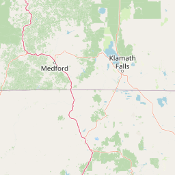
Map view of Red Buttes Wilderness

Use this park location map to pinpoint Red Buttes Wilderness in United States of America, understand its exact geographic position, and read its mapped placement within the surrounding landscape more clearly.

Pigeon | © OpenStreetMap contributors

Location context for Red Buttes Wilderness

CaliforniaOregon
Recorded earthquake history

Explore Historical Earthquake Records for Red Buttes Wilderness

Review recorded seismic activity in the vicinity of Red Buttes Wilderness through an organized historical catalogue. MoriAtlas provides these records to support geographic research and understanding of seismic events documented near this protected wilderness area.

Red Buttes Wilderness Earthquake History

Catalogued events

6 events

Strongest magnitude

Magnitude 3.6

Most recent event

Jun 20, 2022

This history includes earthquakes recorded inside the park or within 50 km of its borders

Explore protected area photography, rugged mountain terrain, and ancient geological scenery.

Red Buttes Wilderness Photos and Landscapes: Visualizing the Siskiyou Crest

Visual documentation reveals the rugged topography, ancient metamorphic rock formations, and dense old-growth forest habitats defining Red Buttes Wilderness. Examining these protected area photographs provides clear insight into the remote alpine geography and distinctive reddish mountain crests spanning the regional mountain range.

A wide view of jagged mountain peaks with patches of snow, surrounded by extensive evergreen coniferous forests in the Red Buttes Wilderness.

A calm, reflective mountain lake surrounded by a dense evergreen forest.

Park atlas

Compare regional mountain geography and connected wilderness areas across the Siskiyou Crest

Explore Other Parks Near Red Buttes Wilderness and Surrounding Protected Landscapes

Visitors exploring Red Buttes Wilderness can browse adjacent protected areas and mountain reserves across the Klamath region. Extending the geographic scope reveals shared botanical communities, rugged terrain profiles, and broader regional park distribution.
An artistic watercolor illustration showing a line of green evergreen trees in the foreground with hazy, distant mountains in the background against a light, neutral sky.
Protected landscapeOregon
Park boundaries overlap#1 closest

West

Rogue River, Siskiyou National Forest: Mapped Geography and Protected Area Overview

Tracing volcanic peaks and river-carved mountain terrain in Oregon

Spanning nearly 7,300 square kilometers, the Rogue River, Siskiyou National Forest acts as a crucial ecological anchor in the Pacific Northwest. This overview details its unique mountain geography, the extensive wilderness tracts within its boundaries, and the river systems that define its mountainous character.

Area
6,973.46 km²
Established
2004
Visitors
915K annual
Relief
Mountain
Watercolor painting of a peaceful river landscape, featuring rolling green hills, dense trees, and distant soft-toned mountains.
Protected areaCalifornia
20 km away#2 closest

Southwest

Six Rivers National Forest: Exploring Protected River Valleys and Mountain Terrain in California

A regional protected area spanning California river systems

Six Rivers National Forest defines much of the rugged landscape in northwestern California. Named for the six major river drainages within its borders, the area features a unique combination of coastal forests, deep river canyons, and high-country ridges that offer significant insight into the region's broader geographic and ecological character.

Area
3,875.2 km²
Established
1947
Relief
Mountain
Climate
Mediterranean
A horizontal watercolor illustration showing a winding river flowing through a lush green valley with rolling hills in the background.
Protected landscapeCalifornia
20 km away#3 closest

West

Smith River National Recreation Area: Mapping the Klamath Mountain Protected Landscape

Watershed geography and rugged mountain terrain in northwestern California

Located in the heart of the Klamath Mountains, Smith River National Recreation Area represents a critical protected watershed in northern California. The area is defined by its deep, forested canyons and the clean, wild waters of the Smith River, which serve as a primary link between coastal redwood ecosystems and mountainous inland terrain. Users can study the park boundaries and regional landscape characteristics that sustain this remote environment.

Area
1,235 km²
Established
1990
Relief
Mountain
Climate
Mediterranean
Protected landscapeCalifornia
25 km away#4 closest

South

Marble Mountain Wilderness: Exploring Protected Mountain Landscapes in Northern California

Klamath Mountains Wilderness and Alpine Geography

Spanning hundreds of thousands of acres, Marble Mountain Wilderness offers a dense concentration of subalpine fir, deep glacial lakes, and steep drainage basins. This northern California protected landscape provides an atlas of rugged ridges and marble-toned peaks that represent one of the most ecologically diverse backcountry areas in the region.

Area
978.3 km²
Established
1964
IUCN
Ib
Relief
Mountain
Wildlife reserveOregon
35 km away#5 closest

Northwest

Kalmiopsis Wilderness: Mapping the Protected Landscapes and Geology of Southwestern Oregon

Botanical richness and dramatic canyon terrain in the Klamath Mountains

Kalmiopsis Wilderness preserves a dramatic landscape of steep ridges and river-cut valleys across 180,000 acres in southwestern Oregon. Known for its distinct serpentine soils and high botanical diversity, the wilderness area offers a look at complex mountain ecology and significant Wild and Scenic River headwaters within the Rogue River-Siskiyou National Forest.

Area
727.44 km²
Established
1964
IUCN
Ib
Relief
Mountain
A watercolor painting of soft, layered mountain ridges and forests in muted green, yellow, and red tones, presented in a wide, horizontal format against a white background.
Protected landscapeCalifornia
About 48 km away#6 closest

South

Klamath National Forest; Protected Landscape Geography and Mapped Wilderness Boundaries

Diverse mountain terrain in Northern California

Klamath National Forest represents a significant protected area in Northern California, encompassing a vast, rugged landscape that bridges the Klamath Mountains and the Cascade Range. Its terrain is characterized by deeply incised river valleys, exposed rocky summits, and an intricate mosaic of coniferous forests. This geographic detail provides essential context on the forest's role as a major site for wilderness protection and ecological study in the Pacific Northwest.

Area
7,033 km²
Established
1905
Relief
Mountain
Climate
Temperate
National parkCalifornia
56 km away#7 closest

Southwest

Redwood National and State Parks: Protected Landscape Geography and Mapped Boundaries

Explore California's protected area atlas.

Gain a structured understanding of Redwood National and State Parks as a protected national park within the geographic context of California. This dedicated page focuses on its mapped boundaries and protected landscape identity, offering critical atlas-level insights for regional geography exploration and conservation land context. Discover how this protected area fits into the larger mapped terrain.

Area
562.88 km²
Established
1968
IUCN
V
Visitors
458.4K annual
A soft watercolor painting depicting a serene landscape with gentle green hills, a small forest, and a calm lake at sunrise or sunset.
Protected landscapeCalifornia
71 km away#8 closest

South

Shasta, Trinity National Forest: Mapping the Protected Landscapes of Northern California

Volcanic peaks, expansive reservoirs, and rugged mountain wilderness

Spanning over two million acres, Shasta, Trinity National Forest represents a major protected landscape in Northern California. The geography includes the iconic Mount Shasta volcano and the complex shoreline of Shasta Lake, while hosting expansive wilderness areas and diverse terrain ranging from oak-forested foothills to alpine meadows.

Area
8,942.87 km²
Established
1954
Relief
Mountain
Climate
Temperate

Common questions about visiting, size, designation, and location context for Red Buttes Wilderness

Red Buttes Wilderness FAQs for park facts, access, geography, and protected area context

Find quick answers about Red Buttes Wilderness, including protected-area facts, park geography, trail and visitor context, and how the park fits into its surrounding country and regional landscape.
MoriAtlas Explorer

Continue Your Protected Areas Search Across the Global Atlas

Deepen your exploration by continuing the structured search for national parks and protected areas worldwide. Utilize the comprehensive filtering capabilities to compare different conservation landscapes and refine your understanding of global park geography. Discover more about the distribution and characteristics of protected natural areas.

Global natural geography