Mori Atlas logo
Nature reserveRéserve naturelle régionale des cheires et grottes de Volvic

Examining the volcanic geography and subterranean ecosystems within the Chaîne des Puys

Réserve naturelle régionale des cheires et grottes de Volvic: A Volcanic Landscape and Protected Bat Habitat

Located on the slopes of the Puy de la Nugère in France, Réserve naturelle régionale des cheires et grottes de Volvic preserves a unique intersection of volcanic geology and cave ecology. This protected area features the rugged cheires lava flows alongside historic underground quarries that serve as essential hibernation sites for bat colonies. The reserve also functions as a critical zone for groundwater protection within the Auvergne volcanic region.

regional nature reservevolcanic landscapecheireslava flowsPuy de la NugèreChaîne des Puys

Réserve naturelle régionale des cheires et grottes de Volvic

Nature reserve

Park overview

Structured park overview, official facts, and landscape profile for Réserve naturelle régionale des cheires et grottes de Volvic

Réserve naturelle régionale des cheires et grottes de Volvic park facts, protected area profile, and essential visitor context

Review the core facts for Réserve naturelle régionale des cheires et grottes de Volvic, including designation, size, terrain, visitor scale, habitats, and operating context in one park-focused overview.

About Réserve naturelle régionale des cheires et grottes de Volvic

The Réserve naturelle régionale des cheires et grottes de Volvic is one of the newer regional nature reserves of Auvergne-Rhône-Alpes, formally established in 2014 within the Puy-de-Dôme department on the outskirts of the commune of Volvic. Although it is small in size, at roughly 61 hectares, the reserve gathers an unusually rich set of natural values into a compact territory by combining a volcanic landscape, historic underground quarries, and groundwater resources.

The surface landscape of the reserve belongs to the Coulées volcano system associated with the Puy de la Nugère, a Strombolian-type cone that produced extensive trachy-andésite lava flows in prehistoric times. Local tradition calls these rugged flows 'cheires,' a word describing the chaotic, clinker-like terrain of lava blocks that remains sparsely vegetated even today. Because this type of volcanic substrate resists weathering and is difficult to cultivate, it has retained a relatively wild character that fits well with nature protection goals.

Below ground, the reserve encompasses three former subterranean quarries that were excavated before the 19th century to extract the famous Volvic stone, a dense, hard lava rock widely used in historic regional architecture and monumental building across France. Once extraction declined, these mine galleries offered stable temperatures, high humidity, and protection from disturbance, conditions that make them ideal for hibernating bats. The reserve thus protects not only a piece of natural geology but also a centuries-old industrial and cultural landscape that has been ecologically reinterpreted in modern times.

Today the protected area brings this geology into active conservation management. The site is administered by the LPO Auvergne, an organization that combines its recognized expertise in bird protection with broader habitat and species work. Surface habitats include young forest and scattered meadows that sustain diverse plant communities, while the cave system shelters a regionally remarkable chiropteran population. Together these elements make the reserve a focused but representative example of how small, multi-purpose protected areas can be woven into the volcanic heritage of the Chaîne des Puys region.

Quick facts and research context for Réserve naturelle régionale des cheires et grottes de Volvic

The reserve is a regional nature reserve (Réserve naturelle régionale) classified by the Auvergne regional council on 23 September 2014 and formally created on 2 October 2014. It is listed under IUCN Category IV and recorded in the World Database on Protected Areas as WDPA site 555561893. The site is managed by LPO Auvergne and receives on the order of 100,000 visitors per year along its walking trails, though the bat-bearing cavities themselves are closed to public access.

Protection and recognition

Documented terrestrial protection scope, designation year, and official database records

Protection Status and Designation History for Réserve naturelle régionale des cheires et grottes de Volvic

Terrestrial protection data for Réserve naturelle régionale des cheires et grottes de Volvic details the established designation history and official WDPA records from 2014. Conservation parameters outline the documented scope without international recognition frameworks.

Protection details

Protection scope
Terrestrial
Designated year
2014
Transboundary protection
No
WDPA ID
555561893
Park context

Deeper park guide and search-rich context for Réserve naturelle régionale des cheires et grottes de Volvic

Réserve naturelle régionale des cheires et grottes de Volvic history, landscape, wildlife, and travel context

Explore Réserve naturelle régionale des cheires et grottes de Volvic through its history, landscape character, ecosystems, wildlife, conservation priorities, cultural context, and seasonal travel timing in a structured park guide built for atlas discovery and search intent.

Why Réserve naturelle régionale des cheires et grottes de Volvic stands out

The reserve is best known for combining two distinctive features of the Auvergne volcanic landscape: the rough cheires lava flows of the Puy de la Nugère, and a network of historic underground quarries that have become the most important hibernation roost for bats in all of Auvergne. It is also recognized for safeguarding key catchment areas that supply the Volvic natural mineral water, making geology, cave ecology, and hydrology tightly linked conservation concerns within a very compact area.

Réserve naturelle régionale des cheires et grottes de Volvic history and protected-area timeline

The history of the reserve begins not with nature protection but with stone quarrying. The trachy-andésite stone of the region, marketed throughout France as Pierre de Volvic, was extracted from underground quarries cut into the lava flows of the Puy de la Nugère, with major workings underway before the 19th century. Because the lava cooled around the galleries rather than collapsing, the quarries remained intact long after extraction slowed and gradually turned into stable cavities of archaeological, geological, and ultimately ecological interest.

Recognition of the site's natural and heritage value led to a coordinated protection effort in the early 2010s, culminating in a decision by the Auvergne regional council on 23 September 2014 to classify the area, with formal creation of the reserve on 2 October 2014. The LPO Auvergne was chosen as the managing organization, bringing its regional expertise in ornithology and species conservation to bear on a site where bat conservation was the most urgent ecological priority. Since then, the reserve has functioned as both a conservation site and an outdoor education resource, welcoming visitors on marked paths while keeping the bat caves themselves carefully closed to public access.

Réserve naturelle régionale des cheires et grottes de Volvic landscape and geographic character

The reserve's landscape is defined by the volcanic geology of the Chaîne des Puys. The Puy de la Nugère, a scoria and lava cone typical of the Massif Central, produced the trachy-andésite flows that the reserve protects. These flows, locally known as cheires, form a jagged terrain of dark volcanic rock blocks with thin soils, creating an open, harsh upper surface that contrasts sharply with the gentler farmland and woodland around Volvic.

The surface area combines rocky outcrops and cheires with patches of young forest and small natural meadows. The mineral substrate explains both the slow colonization by vegetation and the unusually rich bedrock scenery. Below this visible terrain, the underground dimension is just as important: three separate quarry systems tunnel through the lava flows, creating a series of stable subterranean cavities that today's visitors do not normally enter but that define the reserve's broader geological identity.

Réserve naturelle régionale des cheires et grottes de Volvic ecosystems, habitats, and plant life

Ecologically, the reserve protects a compact but layered set of habitats. On the surface, the cheires support open, sun-exposed pioneer vegetation and scattered young woodland, while the deeper pockets within the reserve include closed-canopy young forest, small meadows, and rocky microhabitats. The combination of volcanic soils, varied exposure, and protected status gives the site a botanical interest that goes beyond its more famous underground fauna.

Hydrologically, the reserve is tied to the catchment system of the Volvic natural mineral water, with the protected area encompassing parts of the infiltration and recharge zones that feed the famous springs at Volvic. This means the reserve is not only a biodiversity site but also a functional piece of regional water infrastructure, and disturbance or contamination at the surface can have direct implications for the quality of groundwater captured at depth. The ecological value of the reserve lies precisely in this overlap between volcanic geology, cave ecosystems, surface vegetation, and groundwater protection.

Réserve naturelle régionale des cheires et grottes de Volvic wildlife and species highlights

The single most important wildlife value of the reserve is its bat population. The three quarries together host around 500 individual bats from roughly fifteen species, of which about nine appear regularly. The dominant species include the greater mouse-eared bat (Myotis myotis), the lesser horseshoe bat, and the greater horseshoe bat. Less common but ecologically important species include the Mediterranean horseshoe bat and Geoffroy's bat, contributing to a chiropteran community of regional significance for hibernation.

Above ground, the reserve also supports a community of forest mammals such as the genet and the European wildcat, both of which depend on the mature and semi-mature woodland elements of the site. The bird community is similarly diverse for such a small protected area and includes woodland species such as the Eurasian treecreeper and the wood warbler, which together signal the value of the reserve's young but structurally varied forest cover. The combination of cave-dwelling bats, forest mammals, and breeding woodland birds gives the reserve a notably broad faunal profile despite its limited area.

Réserve naturelle régionale des cheires et grottes de Volvic conservation status and protection priorities

From a conservation standpoint, the reserve is significant less for its size than for the rarity of the assets it protects. The hibernation caves hold what is recognized as the most important bat hibernation site in Auvergne, with a species mix that includes protected taxa of European concern. Because the caves are physically closed to public access, the reserve offers bats a hibernation environment shielded from disturbance, an increasingly rare condition in densely populated European landscapes.

At the same time, the reserve contributes to the protection of a strategic groundwater resource. Volvic's mineral water is closely linked to regional identity and to the broader Chaîne des Puys ecosystem, and zonal protection of the recharge area is a fundamental part of how that watershed is managed. Combining strict bat conservation with watershed stewardship makes the reserve a small-scale example of integrated landscape protection in a volcanic region where surface and underground environments are tightly connected.

Réserve naturelle régionale des cheires et grottes de Volvic cultural meaning and human context

The cultural dimensions of the reserve are inseparable from the volcanic landscape. The name 'Volvic' is itself a brand of stone and of mineral water, and the quarrying of trachy-andésite before the 19th century gave the region durable architecture, including elements of many historic French monuments. The reserve's caves are therefore not only natural cavities but also a piece of the industrial heritage of central France.

Local terminology reinforces this identity. The word 'cheire,' used in the reserve's official name, is itself a regional Occitan-influenced term for the lava fields of the Chaîne des Puys and carries an identity tied to the Massif Central communities that have lived alongside these flows for centuries. The reserve thus preserves a small but meaningful cultural and emblematic piece of Auvergne's volcanic country, recognized not only for its wildlife but also as part of the heritage character of the Volvic area.

Top sights and standout views in Réserve naturelle régionale des cheires et grottes de Volvic

Key points of distinction for the reserve include the protected cheires of the Puy de la Nugère, the three historic underground quarries that now shelter Auvergne's principal bat hibernation colony, and the protected catchment feeding the well-known Volvic natural mineral water. With its young forest, scattered meadows, bat caves, and small surface area, the reserve is a compact example of how volcanic geology, cave biology, and hydrological protection can coexist in a single protected site in the Auvergne region.

Best time to visit Réserve naturelle régionale des cheires et grottes de Volvic

As a small protected area with walking trails and closed bat caves, the reserve is most rewarding in spring and summer when the young forest, scattered meadows, and woodland bird community are most active. Spring brings breeding forest birds such as the wood warbler and Eurasian treecreeper into song, while summer offers the best conditions for appreciating the open cheires landscape and the contrast between rugged volcanic terrain and greener surrounding countryside. Autumn is particularly atmospheric for experiencing the volcanic scenery in more muted light. Because the underground bat-bearing cavities are not open to the public, the surface experience changes relatively little across seasons, but wildlife viewing is generally stronger from late spring through early autumn.

Monthly climate preview

Long-term representative monthly temperature and precipitation rhythm

Réserve naturelle régionale des cheires et grottes de Volvic Climate Normals

Representative coordinate records show average temperatures ranging from below freezing to warm summer highs alongside steady monthly precipitation throughout the year. Examining the full twelve-month profile provides complete historical averages for detailed climate analysis.
Annual mean10 °C
2 °C20 °C
Jan
Feb
Mar
Apr
May13°
Jun17°
Jul20°
Aug20°
Sep15°
Oct11°
Nov
Dec
Warmest month
August

19.9 °C

Coolest month
January

1.9 °C

Wettest month
May

2.5 mm/day

Driest month
February

1.3 mm/day

Park location guide

Geography guide, regional context, and park location map for Réserve naturelle régionale des cheires et grottes de Volvic

Réserve naturelle régionale des cheires et grottes de Volvic park geography, regions, and map view in France

Understand where Réserve naturelle régionale des cheires et grottes de Volvic sits in France through a broader geographic reading of the surrounding landscape, nearby location context, and its mapped position within the national park landscape.

How Réserve naturelle régionale des cheires et grottes de Volvic fits into France

France is a unitary semi-presidential republic and one of the world's largest economies. It borders Belgium, Luxembourg, Germany, Switzerland, Italy, Monaco, Andorra, and Spain, with a maritime border to the United Kingdom. The country is known for its cultural influence, art, cuisine, and political history spanning centuries.

Wider geography shaping Réserve naturelle régionale des cheires et grottes de Volvic in France

France is located in Western Europe. Metropolitan France extends from the Rhine to the Atlantic Ocean and from the Mediterranean Sea to the English Channel and North Sea. The country borders Belgium, Luxembourg, Germany, Switzerland, Italy, Monaco, Andorra, Spain, and has a maritime border with the United Kingdom.

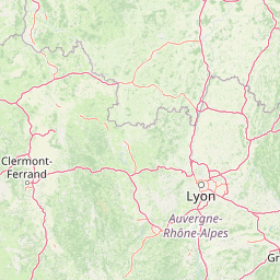
Map view of Réserve naturelle régionale des cheires et grottes de Volvic

Use this park location map to pinpoint Réserve naturelle régionale des cheires et grottes de Volvic in France, understand its exact geographic position, and read its mapped placement within the surrounding landscape more clearly.

Pigeon | © OpenStreetMap contributors

Location context for Réserve naturelle régionale des cheires et grottes de Volvic

Puy-de-Dôme
Recorded earthquake history

View Historical Earthquake Records for Réserve naturelle régionale des cheires et grottes de Volvic

Access a structured collection of recorded seismic events associated with this protected landscape. MoriAtlas provides historical event data including magnitude, depth, and epicentre distance, allowing for a clearer understanding of the seismic context surrounding the Réserve naturelle régionale des cheires et grottes de Volvic.

Volvic Nature Reserve Earthquake History

Catalogued events

23 events

Strongest magnitude

Magnitude 3.8

Most recent event

Sep 10, 2008

This history includes earthquakes recorded inside the park or within 50 km of its borders

Park atlas

Compare nearby volcanic terrain, lava flows, and regional protected landscapes

Other Protected Areas Near Réserve naturelle régionale des cheires et grottes de Volvic

Browsing other protected areas near Réserve naturelle régionale des cheires et grottes de Volvic reveals connected volcanic geology and regional conservation zones. Comparing these surrounding landscapes expands geographic context across the broader Massif Central terrain.
A soft watercolor painting of a wide, rolling landscape with green hills, pale mountain silhouettes in the background, and a faint reddish-brown foreground, presented on a white background.
Natural monumentAuvergne-Rhône-Alpes
Park boundaries overlap#1 closest

South

Chaîne des Puys - faille de Limagne: Mapping Volcanic and Tectonic Protected Landscapes

Geological exploration of the Auvergne-Rhône-Alpes volcanic chain

Spanning a rhythmic skyline of roughly eighty volcanoes, the Chaîne des Puys - faille de Limagne represents a premier site for studying continental rifting and volcanic landforms. This protected monument offers a clear view into the interplay between the ancient mountain basement, the massive Limagne fault, and the resulting volcanic edifices that define the regional identity of the Auvergne-Rhône-Alpes area.

Area
242.23 km²
Established
2018
Relief
Mountain
Climate
Temperate
Nature reserveAuvergne-Rhône-Alpes
About 24 km away#2 closest

Southeast

Réserve naturelle régionale du Puy de Marmant: Volcanic Geography and Protected Terrain

Regional nature reserve in the Auvergne-Rhône-Alpes landscape.

This protected site preserves a prominent volcanic hill and its surrounding dry grasslands within the Limagne basin. The reserve serves as an ecologically significant island, maintaining specialized thermophilous plants and rare geological formations composed of basalt and peperite. It remains an essential reference for understanding the volcanic heritage and unique botanical diversity of the Puy-de-Dôme department.

Area
0.203 km²
Established
1985
IUCN
IV
Relief
Upland
A soft watercolor painting depicting rolling green hills and distant faint mountains under a light sky.
Nature reservePuy-de-Dôme
About 51 km away#3 closest

South

Réserve naturelle nationale du rocher de la Jaquette Protected Area and Volcanic Landscape

Explore rocky cliffs and rare entomological habitats in the Puy-de-Dôme region.

Situated on the flanks of a volcanic outcrop above the Rentières valley, this nature reserve protects a diverse habitat mosaic within the Massif Central. The site provides essential breeding grounds for protected raptors and represents one of the most significant insect sites in central France, offering a clear view into regional volcanic ecology and mountain-valley geography.

Area
0.362 km²
Established
1976
IUCN
IV
Relief
Mountain
A soft, horizontal watercolor painting showing a meandering river winding through lush green riverbanks, with distant rolling hills against a white background.
Nature reserveAllier
58 km away#4 closest

North

Réserve naturelle nationale du val d'Allier Protected Area and River Corridor Map

Alluvial landscape and floodplain geography in central France

The Réserve naturelle nationale du val d'Allier encompasses a mosaic of gravel bars, islands, and side channels shaped by natural river dynamism. This protected expanse showcases a complete riparian forest sequence, providing a rare example of a largely untamed river floodplain preserved for its ongoing geomorphic activity.

Area
14.5 km²
Established
1994
IUCN
IV
Relief
Lowland
A soft watercolor painting of a rolling landscape with green fields, distant purple hills, and patches of yellow and pink vegetation.
Nature reserveAuvergne-Rhône-Alpes
65 km away#5 closest

East

Réserve naturelle régionale des Jasseries de Colleigne Protected Area and Landscape Atlas

High-altitude moorlands and glacial geography in the Monts du Forez

This regional nature reserve provides a critical look at the Hautes Chaumes du Forez, an upland plateau in the Massif Central characterized by open grasslands and peat bogs. The site serves as a vital case study for the conservation of rare montane habitats maintained through traditional pastoral farming practices. Map the glacial Chorsin valley and explore the diverse botanical landscape contained within these protected high-altitude boundaries.

Area
2.85 km²
Established
1985
IUCN
IV
Relief
Mountain
Watercolor painting of a soft, hazy mountain landscape with rolling green fields and a distant forest, set against a light, warm, pale background.
Nature reserveAuvergne-Rhône-Alpes
74 km away#6 closest

South

Réserve naturelle régionale des tourbières du Jolan et de la Gazelle: Geographic Overview

A vital wetland protected area in the Auvergne volcanic highlands.

Located in the Cantal department, the Réserve naturelle régionale des tourbières du Jolan et de la Gazelle features a unique collection of peatland habitats, trembling mires, and acidic grasslands. This area sits within the broader volcanic terrain of the Parc naturel régional des Volcans d'Auvergne, offering a protected catchment for diverse marshland flora and fauna.

Area
1.558 km²
Established
2018
IUCN
IV
Relief
Highland
Nature reserveAuvergne-Rhône-Alpes
About 77 km away#7 closest

Northwest

Espace naturel sensible de la Vauvre Protected Wetland Reserve and Geographic Landscape

Mapping wetland conservation in the Allier department

Covering 46 hectares of reclaimed terrain, this protected nature reserve provides a critical sanctuary for birds and wetland species. The site functions as a documented mosaic of ponds and damp grasslands, offering a clear example of localized ecological restoration within the broader context of the Cher valley geography.

Area
0.46 km²
Established
1996
IUCN
IV
Relief
Lowland
A horizontal watercolor illustration depicting a soft landscape with rolling hills, a body of water in the foreground, and pine trees on the right side.
Nature reserveNouvelle-Aquitaine
About 80 km away#8 closest

West

Réserve naturelle régionale de la haute vallée de la Vézère: Protected Highland Geography

Wetland ecosystems of the Corrèze and Plateau de Millevaches.

Representing a vital network of peatland and bog systems, this nature reserve in the Nouvelle-Aquitaine region preserves essential highland habitats. Its scattered parcels illustrate the complex wetland geography of the Massif Central, offering a focused look at how protected boundaries safeguard specialized ecosystems within the upper Vézère river catchment area.

Area
1.963 km²
Established
2015
IUCN
IV
Relief
Lowland

Common questions about visiting, size, designation, and location context for Réserve naturelle régionale des cheires et grottes de Volvic

Réserve naturelle régionale des cheires et grottes de Volvic FAQs for park facts, access, geography, and protected area context

Find quick answers about Réserve naturelle régionale des cheires et grottes de Volvic, including protected-area facts, park geography, trail and visitor context, and how the park fits into its surrounding country and regional landscape.
MoriAtlas Explorer

Continue Your Protected Areas Search Across the Global Atlas

Deepen your exploration by continuing the structured search for national parks and protected areas worldwide. Utilize the comprehensive filtering capabilities to compare different conservation landscapes and refine your understanding of global park geography. Discover more about the distribution and characteristics of protected natural areas.

Global natural geography